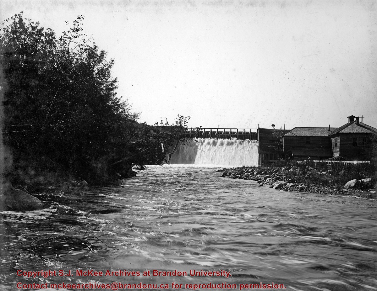
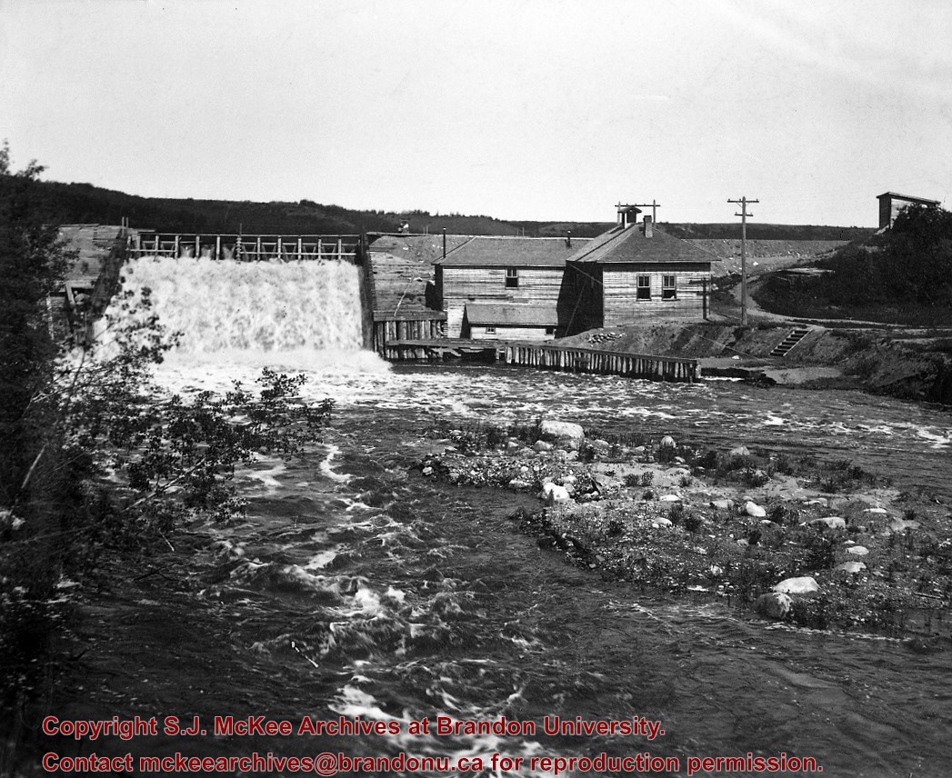
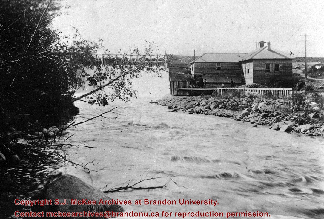
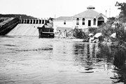
Situated in the R.M. of Whitehead on the Little Saskatchewan River, the 10 Mile Dam was a 14 kilometer transmission line that supplied the city of Brandon with power. The Brandon Electric Light Company built the dam in 1900 and it is considered Manitoba's first hydroelectic power generating station. The dam spanned approximately 80 meters and was constructed from timber and reinforced with clay and stone. The station was decommissioned in 1924.
Scope and Content
Photograph shows 10 Mile Dam, also known as the Brandon Dam or Minnedosa River Hydro Plant.
Notes
Writing on the back of the photograph reads: "10 mile dam". Biographical information obtained from Manitoba Historical Society.
Postcard shows the 100 block of 10th Street facing north. The CPR train station can be seen at the end of 10th Street. The sign for the Rex Cafe is visible on the west side of 10th Street. On the east side of 10th Street, billboards for Campbell & Campbell furniture are visible as well as signs for Pianos and the Orpheum Theatre. Motorists and cyclists share the road. Street car tracks run the length of 10th Street.
Notes
Back of postcard reads: Morning reflection of Brandon's skyline on the Assiniboine River, photo by Sandy Black, printed in Brandno, Manitoba, Canada by Leech Printing Ltd.
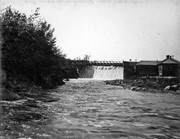
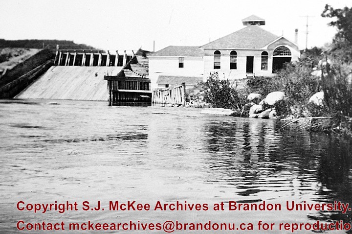
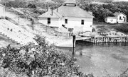
Situated in the R.M. of Whitehead on the Little Saskatchewan River, the 10 Mile Dam was a 14 kilometer transmission line that supplied the city of Brandon with power. The Brandon Electric Light Company built the dam in 1900 and it is considered Manitoba's first hydroelectic power generating station. The dam spanned approximately 80 meters and was constructed from timber and reinforced with clay and stone. The station was decommissioned in 1924.
Scope and Content
Photograph shows 10 Mile Dam, also known as the Brandon Dam or Minnedosa River Hydro Plant. The dam's timber construction is quite evident in the picture.
Notes
Writing on the back of the photograph reads: McGuinness (Manitoba Hydro), on Little Saskatchewan.
Kirkham's Bridge was built in 1906, to replace an earlier wooden bridge. The bridge was used until 1981, when it was purchased by the Town of Birtle and moved to a newsite. A former railway pridge was installed in its place.
Scope and Content
Photograph shows Kirkham's Bridge, a steel truss bridge that spanned the Little Saskatchewan River in the Municipality of Riverdale.
Notes
Identification of the bridge provided by Ken Storie (2023). Additional information taken from the Manitoba Historical Society website.
The Medicine Hat Exhibition and Stampede Parade Day was held on Thursday, July 19, 1962, at 9:30 a.m. The local newspaper reported that approximately 24,000 people were in attendance to see parade marshall Rod Ashburner leading 175 entries consisting of 90 floats, 75 horses, and 10 bands. There were 19 parade categories eligible for $12,000 in prize money and included: junior and senior cowboys and cowgirls; fancy and Shetland ponies; sulky class open; comic, commercial, industrial and organizational floats; decorated cars; special ranch class; 4-H Clubs; and a non-competitive class.
The parade route started at Second St. and Allowance Ave., from Second St. to Ash Ave., north on Ash to First St. SE., from First St. S.E. to Fourth Ave., south to Second St. to South Railway St., south on South Railway St. to Third St., with a finish at McLeod Trail. A route map was published in the Medicine Hat News the day before the parade.
Aerial photographs of the parade were taken by Medicine Hat News photographer Howard Heid (1930-2005) from the private helicopter of John Bourn. Bourn was a pilot from Woodville, Wisconsin, who chartered his four-seater helicopter for sight-seers at exhibitions and stampedes across the county.
(Sources: Pat Currie, "Let 'Er Go!," Medicine Hat News, 19 July 1962,1; Harald Gunderson, "'Eye in the Sky' Best Parade View," Medicine Hat News, 19 July 1962,1; "Parade Starts at 9:30 Sharp," 18 July 1962)
Scope and Content
Photograph shows an aerial view of the Medicine Hat Exhibition and Stampede Parade route with a focus west of the railway allowance, showing First Street SE, Second Street SE, and Third Street SE.
Notes
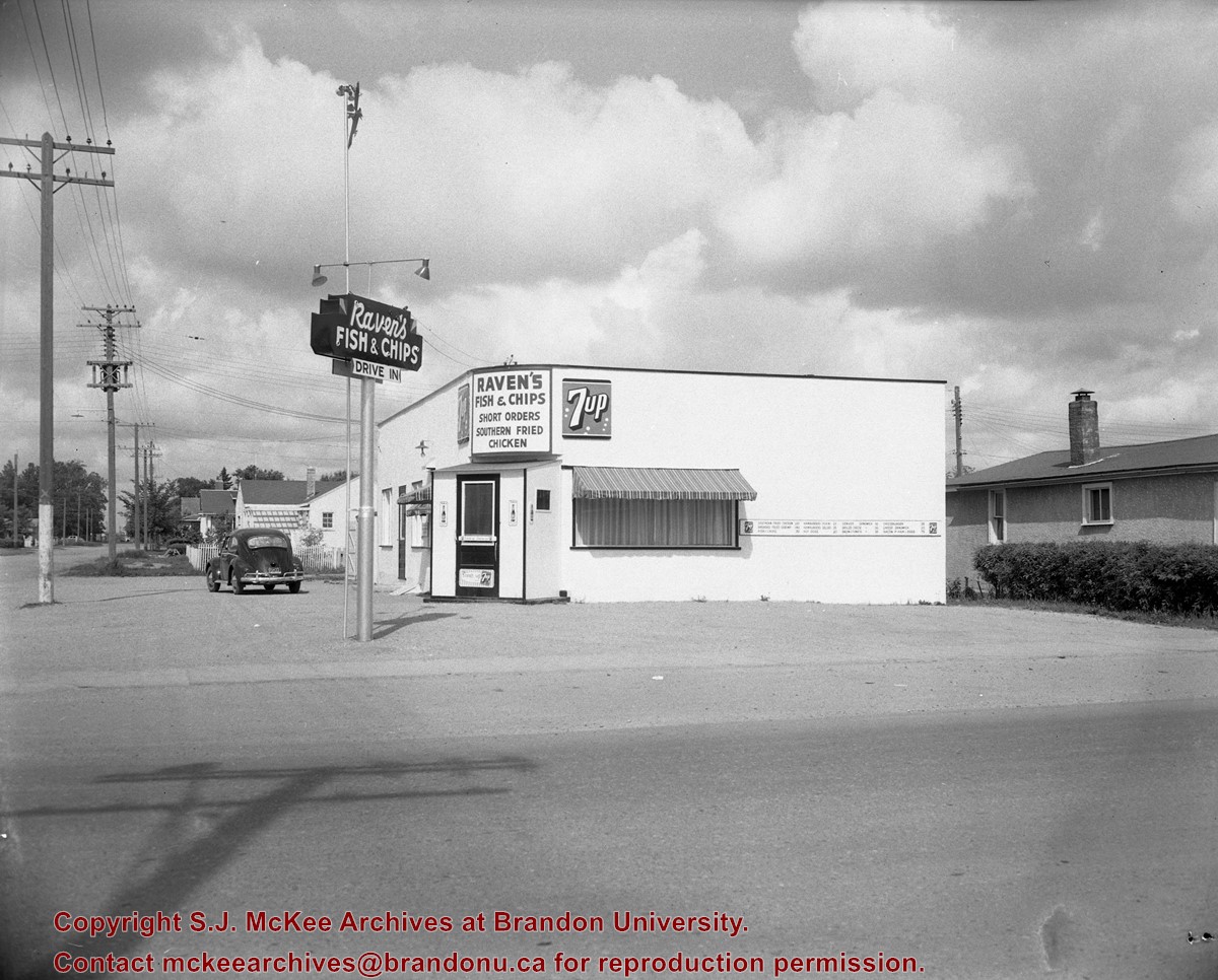
This photograph shows the neighbourhood before rezoning and commercial development.
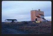
Operated as Pool A, this wooden grain elevator was built by Manitoba Pool Elevators between 1983 and 1984. It was closed by 2007 and demolished by 2008.
Custodial History
Slide was in the possession of John Everitt before its donation to the SJ McKee Archives in 2007.
Scope and Content
Item is an image of the new Manitoba Pool Elevator at Brandon, MB, under construction. The elevator was located at highways #1 and #10.
The SJ McKee Archives is the copyright holder for the John Everitt collection and as such is providing access to the John Everitt slide collection for educational and research purposes only. To publish, copy or otherwise use these images, written permission must be obtained from the SJ McKee Archives. Any issues arising from the use of an item is the responsibility of the persons desiring to use the item, as is the securing of any necessary permissions for use.
For history/bio information see the collection level description of the Lawrence Stuckey collection.
Custodial History
For custodial history see the collection level description of the Lawrence Stuckey collection.
Scope and Content
Series consists of slides created from photographs taken by Lawrence Stuckey during his travels throughout Manitoba, other parts of Canada and the United States. Although Lawrence and his wife Mavis travelled for pleasure, their destinations were often chosen deliberately to enable Lawrence to explore and photograph specific landscapes, flora and fauna.
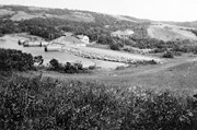
Located about 10 miles west of Brandon on the Little Saskatchewan River, this dam was the first hydroelectric generating station in operation in western Canada. It began supplying power to the city in 1901. This power source, which could not operate in winter, was supplemented by the steam plant on 10th St. By about 1920 the steam plant had been greatly expanded and the hydroelectric plant closed. The old dam was washed out due to a thunder storm in 1948.
Custodial History
For custodial history see the collection level description of the Lawrence Stuckey collection.
Scope and Content
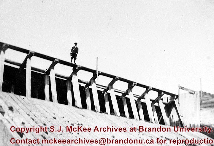
Original Hydroelectric Dam belonging to Brandon Light & Power Co.
Located about 10 miles west of Brandon on the Little Saskatchewan River, this dam was the first hydroelectric generating station in operation in western Canada. It began supplying power to the city in 1901. This power source, which could not operate in winter, was supplemented by the steam plant on 10th St. By about 1920 the steam plant had been greatly expanded and the hydroelectric plant closed. The old dam was washed out due to a thunder storm in 1948.
Custodial History
For custodial history see the collection level description of the Lawrence Stuckey collection.
Scope and Content
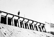
Original Hydroelectric Dam belonging to Brandon Light & Power Co.
Located about 10 miles west of Brandon on the Little Saskatchewan River, this dam was the first hydroelectric generating station in operation in western Canada. It began supplying power to the city in 1901. This power source, which could not operate in winter, was supplemented by the steam plant on 10th St. By about 1920 the steam plant had been greatly expanded and the hydroelectric plant closed. The old dam was washed out due to a thunder storm in 1948.
Custodial History
For custodial history see the collection level description of the Lawrence Stuckey collection.
Scope and Content
Original Hydroelectric Dam belonging to Brandon Light & Power Co.
Notes
[Mr. Stuckey put two negatives (with two views each) in one envelope, numbering each view J3b through J3e. We have separated them.]
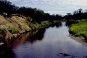
The Snye was a former channel (oxbow lake) of the Assiniboine River. It was located south of the Assiniboine between about 14th and 24th Streets, and during high water in the spring it carried overflow. For many years it was used as a log storage area for Hanbury's Mill. I remember there being bridges over it at 18th & 22nd Streets. It was dammed with a one way flipper valve at 14th Street that allowed water to flow out to the river, but prevented river water backing into it. Water within the Snye became stagnant in summer and formed a breeding area for mosquitoes. It was deemed a health hazard and the river was gradually filled in. LAS.
Custodial History
For custodial history see the collection level description of the Lawrence Stuckey collection.
Scope and Content
Snye River
Notes
[This negative was produced using a previous published image. P.E. 22/07/09]
Additional historical information provided by the Fred McGuinness collection (20-2009).


