Skip header and navigation

Revise Search

20 records – page 1 of 1.

Part Of
RG 11 Lawrence Stuckey fonds
Description Level
Item
GMD
graphic
Date Range
1967
Accession Number
1-2002
Part Of
RG 11 Lawrence Stuckey fonds
Creator
L.A. Stuckey
Description Level
Item
Series Number
3.1
Item Number
1-2002.3.1DE4a
Accession Number
1-2002
GMD
graphic
Date Range
1967
Physical Description
2 1/2" x 2 1/2"
Material Details
Negative
History / Biographical
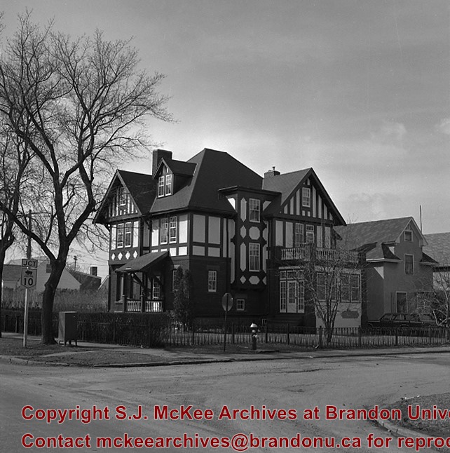
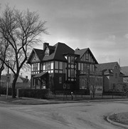
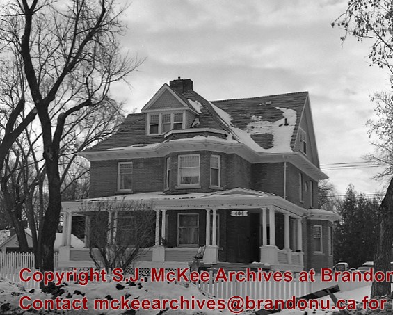
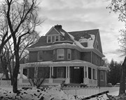
"Maley House was constructed in 1912 by Henry F. Maley, founder and owner of the Brandon Brewery Company. The house was purchased by Dr. McDiarmid, whose family occupied the home for the next sixty years. It is currently used as a bed and breakfast establishment" (Manitoba Culture, Heritage, Tourism and Sport). Maley House is listed as Manitoba Municipal Heritage Site No. 80.
Custodial History
For custodial history see the collection level description of the Lawrence Stuckey collection.
Scope and Content
[Maley House]; Elizabethan style
Notes
Located at 16th St. & Victoria Ave.
[Mr. Stuckey put two negatives in the same envelop, numbering them DE4a and DE4b. We have separated them.]
Name Access
Maley House
Subject Access
houses
Brandon private homes
Manitoba Municipal Heritage Sites
Repro Restriction
The McKee Archives is the copyright holder for the Stuckey materials.
Location Copy
1-2002.3.9.60
Storage Location
Lawrence Stuckey collection
Images
Show Less
Part Of
RG 11 Lawrence Stuckey fonds
Description Level
Item
GMD
graphic
Date Range
March 30, 1980
Accession Number
1-2002
Part Of
RG 11 Lawrence Stuckey fonds
Creator
L.A. Stuckey
Description Level
Item
Series Number
3.1
Item Number
1-2002.3.1DE7
Accession Number
1-2002
GMD
graphic
Date Range
March 30, 1980
Physical Description
2 1/2" x 2 1/2"
Material Details
Negative
History / Biographical
Built 1893. Owner Hughes & Co.
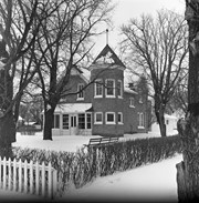
"Built in 1892 by Bell Brothers Construction, Lorne Terrace is a typical terrace house - a facility that combined several addresses in what would appear to be a very large house" (Manitoba Culture, Heritage, Tourism and Sport). It is currently listed as Manitoba Municipal Heritage Site No. 197.
Custodial History
For custodial history see the collection level description of the Lawrence Stuckey collection.
Scope and Content
Lorne Terrace
Notes
Located N. side 1100 block Lorne Ave.
Name Access
Lorne Terrace
Subject Access
houses
Brandon private homes
Manitoba Municipal Heritage Sites
Repro Restriction
The McKee Archives is the copyright holder for the Stuckey materials.
Storage Location
Lawrence Stuckey collection
Images
Show Less
Part Of
RG 11 Lawrence Stuckey fonds
Description Level
Item
GMD
graphic
Date Range
January 29, 1989
Accession Number
1-2002
Part Of
RG 11 Lawrence Stuckey fonds
Creator
L.A. Stuckey
Description Level
Item
Series Number
3.1
Item Number
1-2002.3.1DE19
Accession Number
1-2002
GMD
graphic
Date Range
January 29, 1989
Physical Description
2 1/2" x 2 1/2"
Material Details
Negative
History / Biographical
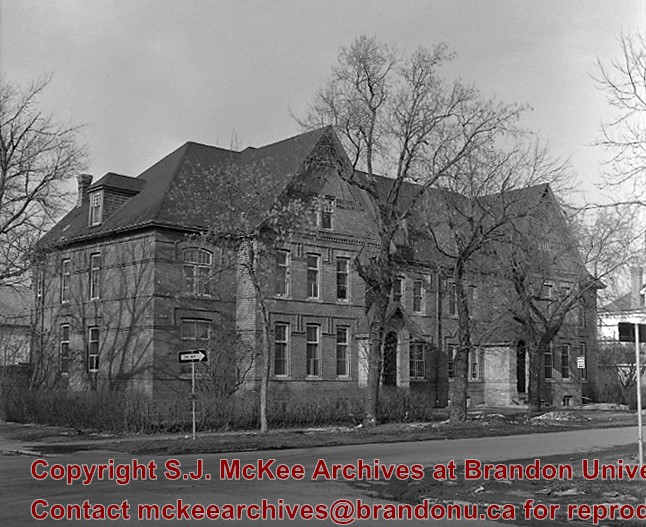
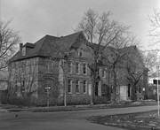
"Christie House was built in 1905 for Ernest Lisle Christie, founder of the huge stationary and school supply business that still bears his name. Christie and his family lived here until 1934, and the house was occupied by other family members until 1966. The house was designed by Brandon architect W.A. Elliott and was constructed by the local firm of G.C. Taylor" (Manitoba Culture, Heritage, Tourism and Sport). Christie House is listed as Manitoba Municipal Heritage Site No. 20.
Custodial History
For custodial history see the collection level description of the Lawrence Stuckey collection.
Scope and Content
Christie House
Notes
Located at 404 13th Street
Name Access
Christie House
Subject Access
houses
Brandon private homes
Manitoba Municipal Heritage Sites
Repro Restriction
The McKee Archives is the copyright holder for the Stuckey materials.
Storage Location
Lawrence Stuckey collection
Images
Show Less

18th International Rally - Wally Byam Caravan Club International

http://archives.brandonu.ca/en/permalink/descriptions10195
Part Of
RG 12 Brandon and Area Photograph Collection
Description Level
Item
GMD
graphic
Date Range
1975
Part Of
RG 12 Brandon and Area Photograph Collection
Description Level
Item
Series Number
6
Item Number
BAPC 6.1
GMD
graphic
Date Range
1975
Publication
Printed by Leech Printing Ltd., Brandon, MB
Physical Description
8.5" x 11" (b/w)
Scope and Content
Aerial photograph of the 18th International Rally of the Wally Byam Caravan Club International held in Brandon, MB at the Keystone Centre.
Name Access
Wally Byam Caravan Club International
Keystone Centre
Subject Access
touring
aerial photographs
Storage Location
BAPC photograph drawer
Images
Show Less

Old mansion, new district museum, Virden, Manitoba

http://archives.brandonu.ca/en/permalink/descriptions10365
Part Of
RG 11 Lawrence Stuckey fonds
Description Level
Item
GMD
graphic
Date Range
January 8, 1979
Accession Number
1-2002
Part Of
RG 11 Lawrence Stuckey fonds
Creator
L.A. Stuckey
Description Level
Item
Series Number
3.3
Item Number
1-2002.3.3.CPR[39]
Accession Number
1-2002
GMD
graphic
Date Range
January 8, 1979
Physical Description
2" x 2" (b/w)
Material Details
Negative
Custodial History
For custodial history see the collection level description of the Lawrence Stuckey collection.
Scope and Content
Image of an old mansion, new district museum, at Virden, Manitoba, taken along the CPR Broadview substation rail lines.
Name Access
Virden, Manitoba
CPR Broadview substation
Subject Access
railways
historic sites
Repro Restriction
The McKee Archives is the copyright holder of the Stuckey materials.
Storage Location
Lawrence Stuckey collection
Images
Show Less

Casselman survey - James Graham writing notes

http://archives.brandonu.ca/en/permalink/descriptions10736
Part Of
RG 7 Beverley Nicholson fonds
Description Level
Item
GMD
graphic
Date Range
2003
Accession Number
1-2010
Part Of
RG 7 Beverley Nicholson fonds
Description Level
Item
Series Number
1.1.5
Item Number
1.1.5.3
Accession Number
1-2010
GMD
graphic
Date Range
2003
Physical Description
1200 x 900 (847 KB )
Material Details
JPEG
Name Access
Casselman survey - photographs
Subject Access
Archaeology Crepeele locale Casselman survey
Images
Show Less

Casselman survey - group on sand dune

http://archives.brandonu.ca/en/permalink/descriptions10737
Part Of
RG 7 Beverley Nicholson fonds
Description Level
Item
GMD
graphic
Date Range
2003
Accession Number
1-2010
Part Of
RG 7 Beverley Nicholson fonds
Description Level
Item
Series Number
1.1.5
Item Number
1.1.5.2
Accession Number
1-2010
GMD
graphic
Date Range
2003
Physical Description
2000 x 1500 (1752 KB )
Material Details
JPEG
Name Access
Casselman survey - photographs
Subject Access
Archaeology Crepeele locale Casselman survey
Images
Show Less

Casselman survey - Lisa Sonneburg and Jolana Bishop

http://archives.brandonu.ca/en/permalink/descriptions10962
Part Of
RG 7 Beverley Nicholson fonds
Description Level
Item
GMD
graphic
Date Range
2003
Accession Number
1-2010
Part Of
RG 7 Beverley Nicholson fonds
Description Level
Item
Series Number
1.1.5
Item Number
1.1.5.4
Accession Number
1-2010
GMD
graphic
Date Range
2003
Physical Description
2000 x 500 (2598 KB )
Material Details
JPEG
Scope and Content
Lisa Sonneburg and Jolana Bishop during the Casselman survey
Name Access
Casselman survey - Lisa Sonneburg and Jolana Bishop
Subject Access
Crepeele locale Casselman survey Casselman survey - photographs
Images
Show Less

Casselman survey - Lisa Sonnenburg, Mike Evans and James Graham

http://archives.brandonu.ca/en/permalink/descriptions10963
Part Of
RG 7 Beverley Nicholson fonds
Description Level
Item
GMD
graphic
Date Range
2003
Accession Number
1-2010
Part Of
RG 7 Beverley Nicholson fonds
Description Level
Item
Series Number
1.1.5
Item Number
1.1.5.5
Accession Number
1-2010
GMD
graphic
Date Range
2003
Physical Description
1200 x 900 (759 KB )
Material Details
JPEG
Scope and Content
Lisa Sonnenburg, Mike Evans and James Graham at the Casselman survey
Name Access
Casselman survey - Lisa Sonnenburg, Mike Evans and James Graham
Subject Access
Archaeology Crepeele locale Casselman survey Casselman survey - photographs
Images
Show Less

Casselman survey - Mike Evans and James Graham

http://archives.brandonu.ca/en/permalink/descriptions10964
Part Of
RG 7 Beverley Nicholson fonds
Description Level
Item
GMD
graphic
Date Range
2003
Accession Number
1-2010
Part Of
RG 7 Beverley Nicholson fonds
Description Level
Item
Series Number
1.1.5
Item Number
1.1.5.6
Accession Number
1-2010
GMD
graphic
Date Range
2003
Physical Description
1200 x 900 (835KB )
Material Details
JPEG
Scope and Content
Mike Evans and James Graham during the Casselman survey
Name Access
Casselman survey - Mike Evans and James Graham
Subject Access
Archaeology Crepeele locale Casselman survey Casselman survey - photographs
Images
Show Less

Casselman survey - Sarah Graham and Mike Evans

http://archives.brandonu.ca/en/permalink/descriptions10967
Part Of
RG 7 Beverley Nicholson fonds
Description Level
Item
GMD
graphic
Date Range
2003
Accession Number
1-2010
Part Of
RG 7 Beverley Nicholson fonds
Description Level
Item
Series Number
1.1.5
Item Number
1.1.5.7
Accession Number
1-2010
GMD
graphic
Date Range
2003
Physical Description
1200 x 900 (933KB )
Material Details
JPEG
Scope and Content
Sarah Graham and Mike Evans surveying at Casselman
Name Access
Casselman survey - Sarah Graham and Mike Evans
Subject Access
Archaeology Crepeele locale Casselman survey Casselman survey - photographs
Images
Show Less

Crepeele site 2003 - Bev Nicholson and James Graham surveying

http://archives.brandonu.ca/en/permalink/descriptions10968
Part Of
RG 7 Beverley Nicholson fonds
Description Level
Item
GMD
graphic
Date Range
2003
Accession Number
1-2010
Part Of
RG 7 Beverley Nicholson fonds
Description Level
Item
Series Number
1.2.1.5
Item Number
1.2.1.5.1
Accession Number
1-2010
GMD
graphic
Date Range
2003
Physical Description
432x324 (221KB )
Material Details
JPEG
Scope and Content
Bev Nicholson and James Graham surveying at the Crepeele site 2003.
Name Access
Crepeele site 2003 - Bev Nicholson and James Graham surveying
Subject Access
Archaeology Crepeele locale Crepeele site DiMe-29 Crepeele site 2003 - photographs
Images
Show Less

Casselman survey - ceramic rim sherd

http://archives.brandonu.ca/en/permalink/descriptions10972
Part Of
RG 7 Beverley Nicholson fonds
Description Level
Item
GMD
graphic
Date Range
2003
Accession Number
1-2010
Part Of
RG 7 Beverley Nicholson fonds
Description Level
Item
Series Number
1.1.5
Item Number
1.1.5.9
Accession Number
1-2010
GMD
graphic
Date Range
2003
Physical Description
1200 x 900 (363KB )
Material Details
JPEG
Scope and Content
Cord-wrapped stick impressions on ceramic rim sherd.
Name Access
Casselman survey - ceramic rim sherd
Subject Access
Crepeele locale Casselman survey Casselman survey - photograph
Images
Show Less

Casselman survey - lithic bifaces

http://archives.brandonu.ca/en/permalink/descriptions10973
Part Of
RG 7 Beverley Nicholson fonds
Description Level
Item
GMD
graphic
Date Range
2003
Accession Number
1-2010
Part Of
RG 7 Beverley Nicholson fonds
Description Level
Item
Series Number
1.1.5
Item Number
1.1.5.10
Accession Number
1-2010
GMD
graphic
Date Range
2003
Physical Description
2000 x 1333 (525KB )
Material Details
JPEG
Scope and Content
Lithic bifaces (stone tools) from Casselman survey
Name Access
Casselman survey - photographs
Subject Access
Archaeology Crepeele locale Casselman survey
Images
Show Less

Casselman survey - lithic side-notched points

http://archives.brandonu.ca/en/permalink/descriptions10974
Part Of
RG 7 Beverley Nicholson fonds
Description Level
Item
GMD
graphic
Date Range
2003
Accession Number
1-2010
Part Of
RG 7 Beverley Nicholson fonds
Description Level
Item
Series Number
1.1.5
Item Number
1.1.5.11
Accession Number
1-2010
GMD
graphic
Date Range
2003
Physical Description
1200 x 900 (422KB )
Material Details
JPEG
Scope and Content
Lithic side-notched points from Casselman survey
Name Access
Casselman survey - photographs
Subject Access
Archaeology Crepeele locale Casselman survey
Images
Show Less

Casselman survey - Bev Nicholson leading a group through the Crepeele locale

http://archives.brandonu.ca/en/permalink/descriptions10979
Part Of
RG 7 Beverley Nicholson fonds
Description Level
Item
GMD
graphic
Date Range
2003
Accession Number
1-2010
Part Of
RG 7 Beverley Nicholson fonds
Description Level
Item
Series Number
1.1.5
Item Number
1.1.5.1
Accession Number
1-2010
GMD
graphic
Date Range
2003
Physical Description
2500 x 1875 (3233 KB )
Material Details
JPEG
Scope and Content
Bev Nicholson leading a group through the Crepeele locale during the Casselman survey
Name Access
Casselman survey - Bev Nicholson leading a group through the Crepeele locale
Subject Access
Archaeology Crepeele locale Casselman survey Casselman survey - photographs
Images
Show Less

Aerial view - Brandon University campus

http://archives.brandonu.ca/en/permalink/descriptions7989
Part Of
Brandon University Photograph collection
Description Level
Item
GMD
graphic
Date Range
c. 2000
Part Of
Brandon University Photograph collection
Creator
Photograph commissioned by Brandon University and taken by Yourview Aerial Scenics Ltd.
Description Level
Item
Series Number
2.1
Item Number
BUPC 2.1.55
GMD
graphic
Date Range
c. 2000
Physical Description
6" x 4" (colour)
Scope and Content
View is southwest from approximatley 16th Street between Princess and Rosser Avenues. Photograph shows the Brandon University campus, as well as surrounding residential blocks, including Flemming, J.R. Reid and Vincent Massey schools.
Subject Access
aerial photographs
campus photographs
campus buildings
Brandon streets
Images
Show Less

Aerial view - Brandon University campus

http://archives.brandonu.ca/en/permalink/descriptions7990
Part Of
Brandon University Photograph collection
Description Level
Item
GMD
graphic
Date Range
c. 2000
Part Of
Brandon University Photograph collection
Creator
Photograph commissioned by Brandon University and taken by Yourview Aerial Scenics Ltd.
Description Level
Item
Series Number
2.1
Item Number
BUPC 2.1.56
GMD
graphic
Date Range
c. 2000
Physical Description
6" x 4" (colour)
Scope and Content
View is west southwest from approximatley 16th Street between Princess and Lorne Avenues. Photograph shows the Brandon University campus, as well as surrounding residential blocks between 16th and 23rd Streets, Princess and Louise Avenues..
Subject Access
aerial photographs
campus photographs
campus buildings
Brandon streets
Images
Show Less

Aerial view - Brandon University campus

http://archives.brandonu.ca/en/permalink/descriptions7991
Part Of
Brandon University Photograph collection
Description Level
Item
GMD
graphic
Date Range
c. 2000
Part Of
Brandon University Photograph collection
Creator
Photograph commissioned by Brandon University and taken by Yourview Aerial Scenics Ltd.
Description Level
Item
Series Number
2.1
Item Number
BUPC 2.1.57
GMD
graphic
Date Range
c. 2000
Physical Description
6" x 4" (colour)
Scope and Content
View is west from approximatley 17th Street between Lorne and Louise Avenues. Photograph shows a portion of the Brandon University campus (excluding the Education Building and anything north of it), as well as surrounding residential blocks from approximatley 17th Street to 22nd Street.
Subject Access
aerial photographs
campus photographs
campus buildings
Brandon streets
Images
Show Less

Aerial view - Brandon University campus

http://archives.brandonu.ca/en/permalink/descriptions7992
Part Of
Brandon University Photograph collection
Description Level
Item
GMD
graphic
Date Range
c. 1990
Part Of
Brandon University Photograph collection
Description Level
Item
Series Number
2.1
Item Number
BUPC 2.1.58
GMD
graphic
Date Range
c. 1990
Physical Description
5" x 3.5" (colour)
Scope and Content
View is west northwest from approximatley 16th Street and Louise Avenue. Photograph shows the Brandon University campus, prior to the Library Extension, and a large portion of the city to the west of the campus.
Subject Access
aerial photographs
campus photographs
campus buildings
Brandon streets
Images
Show Less

20 records – page 1 of 1.