Skip header and navigation

Revise Search

20 records – page 1 of 1.

Modern school geography and atlas : authorized by the councils of Public Instruction for the provinces of Ontario, Quebec, New Brunswick and Prince Edward Island

http://archives.brandonu.ca/en/permalink/specialcollections980
Part Of
MG 2 2.15 George E Thorman Collection
Description Level
Item
Date Range
1879
Part Of
MG 2 2.15 George E Thorman Collection
Collection
George E Thorman School Textbook Collection
Description Level
Item
Item Number
Archives 11-999-12-340
Item Number Range
Archives 11-999-12-340
Start Date
1879
Date Range
1879
Publication
Toronto : James Campbell and Son
Physical Description
87 p., [33] leaves of plates : ill., col. maps, ; 22 cm
Subject Access
Atlases
Canadian
Geography Text-books 1870-1945
Storage Location
Box 12 - Geography
Storage Range
Box 12 - Geography
Show Less

An advanced history of Great Britain from the earliest times to the death of Edward VII

http://archives.brandonu.ca/en/permalink/specialcollections1071
Part Of
MG 2 2.15 George E Thorman Collection
Description Level
Item
Date Range
1912
Part Of
MG 2 2.15 George E Thorman Collection
Collection
George E Thorman School Textbook Collection
Creator
Tout, T. F. (Thomas Frederick), 1855-1929
Description Level
Item
Item Number
Archives 11-999-16-441
Item Number Range
Archives 11-999-16-441
Responsibility
by T. F. Tout
Start Date
1912
Date Range
1912
Publication
London : Longmans, Green
Publisher Series
Longmans' historical Series for schools ; Book III
Physical Description
xlii, 767 p. : ill. (maps, plans) ; 19 cm
Subject Access
Great Britain History
Storage Location
Box 16 - History
Storage Range
Box 16 - History
Show Less
Part Of
RG 4 Manitoba Pool Elevator fonds
Description Level
Item
Date Range
1975
Part Of
RG 4 Manitoba Pool Elevator fonds
Collection
Manitoba Pool Elevator Library Collection
Creator
United States. Dept. of Agriculture
Description Level
Item
Item Number
S 21.A35 1975
Archives 14-11-8
Item Number Range
S 21.A35 1975
Archives 14-11-8
Standard number
System Control Number 76209619
Responsibility
U.S. Department of Agriculture
Start Date
1975
Date Range
1975
Publication
Washington, D.C. : United State Government Printing Office
Publisher Series
Yearbook of agriculture ; 1975
Physical Description
xxxviii, 362 p. : ill. (some col.) ; 24 cm
Notes
Includes index
Subject Access
Agricultural research United States
Food research United States
Agricultural experiment stations United States
Agriculture United States
Storage Location
Box 11 - Agriculture II (Archives copy)
Storage Range
Box 11 - Agriculture II (Archives copy)
Show Less

Untitled (Man drawing)

http://archives.brandonu.ca/en/permalink/artworks926
Artist
Pimentel, Frank
Collection
Dunlands Restaurant
Date
1987
Accession Number
317
Title Variation
Man drawing
Artist
Pimentel, Frank
Collection
Dunlands Restaurant
Date
1987
Dimensions
31 X 31 cm
Size Overall
52.5 X 51.5 cm
Medium
Ektacolor photograph
Condition
good
Primary Support
paper
Secondary Support
mat, plexiglass, backing board; frame - metal
Accession Number
317
Show Less

City Hall and Prince Edward Hotel

http://archives.brandonu.ca/en/permalink/descriptions6426
Part Of
Alf Fowler collection
Description Level
Item
GMD
graphic
Date Range
ca. 1911
Accession Number
6-1999
Part Of
Alf Fowler collection
Creator
Davidson & Gowen
Description Level
Item
Item Number
6-1999.1
Accession Number
6-1999
GMD
graphic
Date Range
ca. 1911
Physical Description
9.5" x 7.25" (b/w)
Custodial History
See fonds level description of the Alf Fowler collection for custodial history.
Scope and Content
Photo was taken from the west side of 8th Street looking west. City Hall is in the foreground with the Prince Edward Hotel in the background.
Storage Range
RG 5 Western Manitoba Manuscript collection - photograph storage drawer
Images
Show Less

Grand Stand drawing

http://archives.brandonu.ca/en/permalink/descriptions6485
Part Of
Alf Fowler collection
Description Level
Item
GMD
graphic
Date Range
ca. 1911
Accession Number
6-1999
Part Of
Alf Fowler collection
Creator
Davidson & Gowen
Description Level
Item
Item Number
6-1999.60
Accession Number
6-1999
GMD
graphic
Date Range
ca. 1911
Physical Description
9.25" x 5" (b/w)
Custodial History
See fonds level description of the Alf Fowler collection for custodial history.
Scope and Content
Drawing of the (proposed?) Grand Stand for The Western Agricultural & Arts Association by Shillinglaw & Marshall, architects, Brandon.
Storage Range
RG 5 Western Manitoba Manuscript collection - photograph storage drawer
Images
Show Less
Part Of
Alf Fowler collection
Description Level
Item
GMD
graphic
Date Range
ca. 1911
Accession Number
6-1999
Part Of
Alf Fowler collection
Creator
Davidson & Gowen
Description Level
Item
Item Number
6-1999.73
Accession Number
6-1999
GMD
graphic
Date Range
ca. 1911
Physical Description
9.25" x 7" (b/w)
History / Biographical
The Beaubier Hotel is located at 205 8th Street.
Custodial History
See fonds level description of the Alf Fowler collection for custodial history.
Scope and Content
Photo shows the Beaubier Hotel. The view is looking southeast.
Storage Range
RG 5 Western Manitoba Manuscript collection - photograph storage drawer
Images
Show Less
Part Of
Alf Fowler collection
Description Level
Item
GMD
graphic
Date Range
ca. 1911
Accession Number
6-1999
Part Of
Alf Fowler collection
Creator
Davidson & Gowen
Description Level
Item
Item Number
6-1999.74
Accession Number
6-1999
GMD
graphic
Date Range
ca. 1911
Physical Description
9.25" x 7.25" (b/w)
History / Biographical
The King Edward Hotel was located at 916 Pacific Avenue.
Custodial History
See fonds level description of the Alf Fowler collection for custodial history.
Scope and Content
Photo shows the King Edward Hotel.
Storage Range
RG 5 Western Manitoba Manuscript collection - photograph storage drawer
Images
Show Less
Part Of
Alf Fowler collection
Description Level
Item
Accession Number
6-1999
Part Of
Alf Fowler collection
Description Level
Item
Item Number
6-1999.75
Accession Number
6-1999
Physical Description
9.25" x 7.25" (b/w)
Storage Range
RG 5 Western Manitoba Manuscript collection - photograph storage drawer
Images
Show Less

Prince Edward Hotel

http://archives.brandonu.ca/en/permalink/descriptions6500
Part Of
Alf Fowler collection
Description Level
Item
GMD
graphic
Date Range
ca. 1911
Accession Number
6-1999
Part Of
Alf Fowler collection
Creator
Davidson & Gowen
Description Level
Item
Item Number
6-1999.76
Accession Number
6-1999
GMD
graphic
Date Range
ca. 1911
Physical Description
9.5" x 7.25" (b/w)
History / Biographical
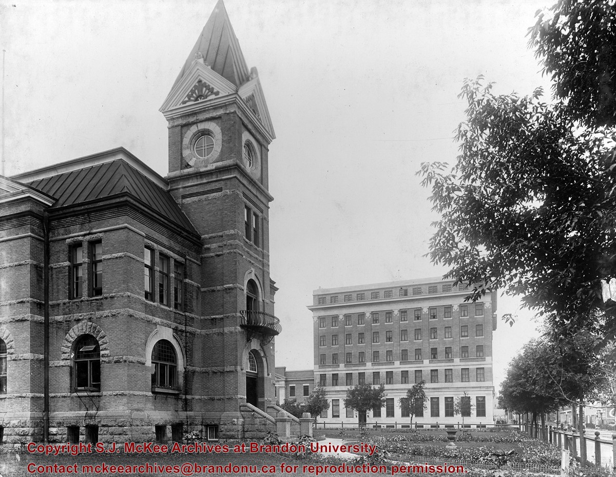
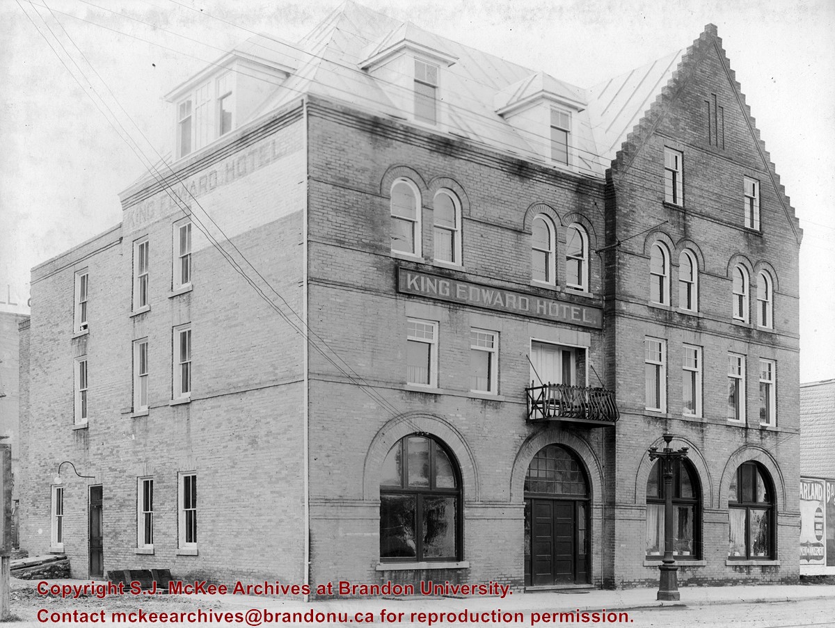
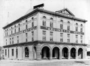
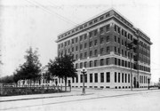
The Prince Edward Hotel was located on the south side of Princess Avenue between 9th and 10th Streets. Completed in 1912, the Prince Eddy opened with a charity ball on June 1, 1912. The site, occupied by the Salvation Army Barracks, was purchased in 1907 by the Canadian Northern Railway, later part of the Canadian National Railway. Designed by Winnipeg architects Pratt & Ross, the Prince Eddy was a six storey brick structure built of reinforced concrete, with walls of Tyndall limestone and Roman brick. Connected to the hotel on the south was the railway terminus, which housed offices and waiting rooms. Both the hotel and station were demolished in 1980.
Custodial History
See fonds level description of the Alf Fowler collection for custodial history.
Scope and Content
Photo shows the Prince Edward Hotel. The view is southwest.
Notes
History/Bio information taken from the Assiniboine Historical Society's Brandon: An Architectural Walking Tour pamphlet (1982).
Storage Range
RG 5 Western Manitoba Manuscript collection - photograph storage drawer
Images
Show Less
Part Of
Alf Fowler collection
Description Level
Item
Accession Number
6-1999
Part Of
Alf Fowler collection
Description Level
Item
Item Number
6-1999.77
Accession Number
6-1999
Physical Description
9" x 7.25" (b/w)
Storage Range
RG 5 Western Manitoba Manuscript collection - photograph storage drawer
Images
Show Less

Aerial view - Brandon University campus

http://archives.brandonu.ca/en/permalink/descriptions7989
Part Of
Brandon University Photograph collection
Description Level
Item
GMD
graphic
Date Range
c. 2000
Part Of
Brandon University Photograph collection
Creator
Photograph commissioned by Brandon University and taken by Yourview Aerial Scenics Ltd.
Description Level
Item
Series Number
2.1
Item Number
BUPC 2.1.55
GMD
graphic
Date Range
c. 2000
Physical Description
6" x 4" (colour)
Scope and Content
View is southwest from approximatley 16th Street between Princess and Rosser Avenues. Photograph shows the Brandon University campus, as well as surrounding residential blocks, including Flemming, J.R. Reid and Vincent Massey schools.
Subject Access
aerial photographs
campus photographs
campus buildings
Brandon streets
Images
Show Less

Aerial view - Brandon University campus

http://archives.brandonu.ca/en/permalink/descriptions7990
Part Of
Brandon University Photograph collection
Description Level
Item
GMD
graphic
Date Range
c. 2000
Part Of
Brandon University Photograph collection
Creator
Photograph commissioned by Brandon University and taken by Yourview Aerial Scenics Ltd.
Description Level
Item
Series Number
2.1
Item Number
BUPC 2.1.56
GMD
graphic
Date Range
c. 2000
Physical Description
6" x 4" (colour)
Scope and Content
View is west southwest from approximatley 16th Street between Princess and Lorne Avenues. Photograph shows the Brandon University campus, as well as surrounding residential blocks between 16th and 23rd Streets, Princess and Louise Avenues..
Subject Access
aerial photographs
campus photographs
campus buildings
Brandon streets
Images
Show Less

Aerial view - Brandon University campus

http://archives.brandonu.ca/en/permalink/descriptions7991
Part Of
Brandon University Photograph collection
Description Level
Item
GMD
graphic
Date Range
c. 2000
Part Of
Brandon University Photograph collection
Creator
Photograph commissioned by Brandon University and taken by Yourview Aerial Scenics Ltd.
Description Level
Item
Series Number
2.1
Item Number
BUPC 2.1.57
GMD
graphic
Date Range
c. 2000
Physical Description
6" x 4" (colour)
Scope and Content
View is west from approximatley 17th Street between Lorne and Louise Avenues. Photograph shows a portion of the Brandon University campus (excluding the Education Building and anything north of it), as well as surrounding residential blocks from approximatley 17th Street to 22nd Street.
Subject Access
aerial photographs
campus photographs
campus buildings
Brandon streets
Images
Show Less

Aerial view - Brandon University campus

http://archives.brandonu.ca/en/permalink/descriptions7992
Part Of
Brandon University Photograph collection
Description Level
Item
GMD
graphic
Date Range
c. 1990
Part Of
Brandon University Photograph collection
Description Level
Item
Series Number
2.1
Item Number
BUPC 2.1.58
GMD
graphic
Date Range
c. 1990
Physical Description
5" x 3.5" (colour)
Scope and Content
View is west northwest from approximatley 16th Street and Louise Avenue. Photograph shows the Brandon University campus, prior to the Library Extension, and a large portion of the city to the west of the campus.
Subject Access
aerial photographs
campus photographs
campus buildings
Brandon streets
Images
Show Less

Aerial view - Brandon University campus

http://archives.brandonu.ca/en/permalink/descriptions7993
Part Of
Brandon University Photograph collection
Description Level
Item
GMD
graphic
Date Range
c. 1990
Part Of
Brandon University Photograph collection
Description Level
Item
Series Number
2.1
Item Number
BUPC 2.1.59
GMD
graphic
Date Range
c. 1990
Physical Description
5" x 3.5" (colour)
Scope and Content
View is northwest from approximatley 16th Street and Louise Avenue. Photograph shows the Brandon University campus, prior to the Library Extension, and a large portion of the city to the west of the campus.
Subject Access
aerial photographs
campus photographs
campus buildings
Brandon streets
Show Less
Part Of
Brandon University Photograph collection
Description Level
Item
GMD
graphic
Date Range
c. 1985
Part Of
Brandon University Photograph collection
Description Level
Item
Series Number
2.1
Item Number
BUPC 2.1.60
GMD
graphic
Date Range
c. 1985
Physical Description
5" x 3.5" (colour)
Scope and Content
Photograph shows the removal of one of the houses formerly located on 20th Street between Louise and Princess Avenues. The houses on those blocks were removed to create parking lots for the University. A Fed Zavislak Ltd. Well Drilling & Trucking pickup truck is visible at the curb.
Subject Access
campus photographs
Brandon streets
Images
Show Less
Part Of
Brandon University Photograph collection
Description Level
Item
GMD
graphic
Date Range
c. 1985
Part Of
Brandon University Photograph collection
Description Level
Item
Series Number
2.1
Item Number
BUPC 2.1.61
GMD
graphic
Date Range
c. 1985
Physical Description
5" x 3.5" (colour)
Scope and Content
Photograph shows the removal of one of the houses formerly located on 20th Street between Louise and Princess Avenues. The houses on those blocks were removed to create parking lots for the University.
Subject Access
campus photographs
Brandon streets
Images
Show Less

Brandon University campus construction

http://archives.brandonu.ca/en/permalink/descriptions8005
Part Of
Brandon University Photograph collection
Description Level
Item
GMD
graphic
Date Range
c. 1996
Part Of
Brandon University Photograph collection
Creator
Photographer: Sandy Black
Description Level
Item
Series Number
2.1
Item Number
BUPC 2.1.71
GMD
graphic
Date Range
c. 1996
Physical Description
4" x 6" (colour)
Scope and Content
View is northeast probably from the roof of McMaster Hall. Photograph shows the construction of the new roof on Clark Hall and the Brandon College Building. A portion of the east side of the 000 and 100 blocks of 18th Street, as well as the corner of 18th Street and Rosser Avenue are visible in the upper left hand corner. This includes the "Downtown Brandon" sign.
Subject Access
campus photographs
campus buildings
campus construction
Brandon streets
Images
Show Less

Brandon University campus construction

http://archives.brandonu.ca/en/permalink/descriptions8006
Part Of
Brandon University Photograph collection
Description Level
Item
GMD
graphic
Date Range
c. 1996
Part Of
Brandon University Photograph collection
Creator
Photographer: Sandy Black
Description Level
Item
Series Number
2.1
Item Number
BUPC 2.1.72
GMD
graphic
Date Range
c. 1996
Physical Description
6" x 4" (colour)
Scope and Content
View is north northeast probably from the roof of McMaster Hall. Photograph shows the construction of the new roof on Clark Hall and the Brandon College Building, as well as the construction of the extension to Clark Hall and the skywalk. Portions of the city as far north as the Assiniboine River are also visible.
Subject Access
campus photographs
campus buildings
campus construction
Brandon streets
Images
Show Less

20 records – page 1 of 1.