Skip header and navigation

Revise Search

20 records – page 1 of 1.

Brandon Normal School spring class

http://archives.brandonu.ca/en/permalink/descriptions13617
Part Of
Brandon and Area Photograph Collection
Description Level
Item
GMD
electronic records
Date Range
Spring 1912
Accession Number
4-2014
Part Of
Brandon and Area Photograph Collection
Creator
Photographer: Clark J. Smith
Description Level
Item
Series Number
4
Item Number
BAPC 4.34
Accession Number
4-2014
GMD
electronic records
Date Range
Spring 1912
Physical Description
5849 KB
Material Details
JPG
Custodial History
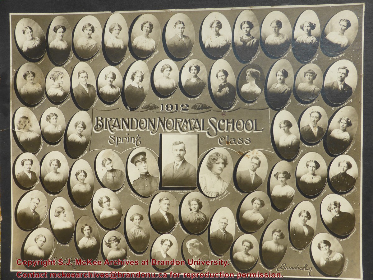
The original photograph remains in the custody of the donor, who scanned the digital copy and sent it to the McKee Archives in 2014. The donor's paternal grandmother graduated from Brandon Normal School in the Spring of 1912.
Scope and Content
Portrait of the students of Brandon Normal School Spring 1912 class.
Name Access
Brandon Normal School
Subject Access
Education
class portraits
secondary education
Location Original
Original physical copy remains with the donor.
Storage Location
T:\Library\Archives\Shared.02\photos\BAPC\BAPC_4_34.jpg
Images
Show Less

Brandon Normal School fall term 1917

http://archives.brandonu.ca/en/permalink/descriptions13652
Part Of
Brandon and Area Photograph Collection
Description Level
Item
GMD
graphic
Date Range
1917
Accession Number
3-2015
Part Of
Brandon and Area Photograph Collection
Creator
Photographer: Davidson Studio
Description Level
Item
Series Number
4
Item Number
BAPC 4.35
Accession Number
3-2015
GMD
graphic
Date Range
1917
Physical Description
12.5" x 9.5" (b/w)
Material Details
On matting
Physical Condition
Some staining in upper right quadrant.
Scope and Content
Composite portrait of the Brandon Normal School Fall Term 1917 class. B.J. Hales, Principal, W. Beer, Vice-Principal, M. Reid, Asst. Teacher, M. Yeomans, Drill Instructor.
Notes
Part of the Chapman Museum collection.
Name Access
Brandon Normal School
M. DeWitt
A. McCormack
L. Morden
S. Field
W. Maguire
S. Billinski
T. Bilous
E. Stoddart
E. Riddell
V. Carrick
M. Kelly
M. Hill
E. Rowley
E. Abey
F. Blair
B. Maxfield
C. Crawford
S. Kozak
J. Thomson
R. Wallace
M. Abey
V. Glover
S. Strath
D. Hill
A. Tycki
R. McCallum
E. Charters
B.J. Hales
W. Beer
D. Aldis
H. Henwood
L. Brad
M. Gillis
B. Sanford
E. Fowler
E. Krog
I. Lindsay
E. Dick
E. Hall
E. McIntyre
G. Tilley
M. Reid
M. Yeomans
A. Jones
D. Flewitt
E. Rutherford
B. Rose
M. Berlet
M. Scharff
H. Hall
F. Morden
D. McGillivray
N. Parsnage
B. Robins
V. Sandercock
D. Horton
A. Hrudka
J. Chriptyk
H. Tanner
K. Averill
E. Radomski
M. Saranchuk
M. Babcok
Subject Access
Education
class portraits
secondary education
Storage Location
BAPC oversize storage drawer 2
Show Less

Aerial view: Brandon College looking west

http://archives.brandonu.ca/en/permalink/descriptions595
Part Of
Aerial views and campus photographs
Description Level
Item
GMD
graphic
Date Range
c. spring 1963
Part Of
Aerial views and campus photographs
Description Level
Item
Series Number
2.1
Item Number
2.1.3
GMD
graphic
Date Range
c. spring 1963
Physical Description
10" x 8" (b/w)
Scope and Content
View is west to McDiarmid Drive from approximately 16th Street between Princess and Louise Avenues. Photograph shows: Brandon College, Fleming School, Coronation Park, and West End Community Centre.
Images
Show Less

Aerial view: Brandon College Steam Plant

http://archives.brandonu.ca/en/permalink/descriptions596
Part Of
Aerial views and campus photographs
Description Level
Item
GMD
graphic
Date Range
c. spring 1963
Part Of
Aerial views and campus photographs
Description Level
Item
Series Number
2.1
Item Number
2.1.4
GMD
graphic
Date Range
c. spring 1963
Physical Description
10" x 8" (b/w)
Scope and Content
View is northwest from the corner of 18th Street and Louise Avenue. Photograph shows the Brandon College campus, the Steam Plant and Kinsmen Stadium. Flora Cowan Hall is under construction.
Images
Show Less

Aerial view: Brandon College and downtown east

http://archives.brandonu.ca/en/permalink/descriptions597
Part Of
Aerial views and campus photographs
Description Level
Item
GMD
graphic
Date Range
c. spring 1963
Part Of
Aerial views and campus photographs
Description Level
Item
Series Number
2.1
Item Number
2.1.5
GMD
graphic
Date Range
c. spring 1963
Physical Description
10" x 8" (b/w)
Scope and Content
View is east southeast from approximately 22nd Street between Princess and Louise Avenues. Photograph shows: Brandon College, Stanley Park, Park School, Prince Edward Hotel, First Baptist Church, First Presbyterian Church, Wheat City Arena, First Church United, St. Paul's, Central United Church.
Images
Show Less

Aerial view: Brandon College and downtown core

http://archives.brandonu.ca/en/permalink/descriptions598
Part Of
Aerial views and campus photographs
Description Level
Item
GMD
graphic
Date Range
c. spring 1963
Part Of
Aerial views and campus photographs
Description Level
Item
Series Number
2.1
Item Number
2.1.6
GMD
graphic
Date Range
c. spring 1963
Physical Description
10" x 8" (b/w)
Scope and Content
View is southeast from 21st Street and Princess Avenue. Photograph shows: Brandon College, Wheat City Arena, Armories, Reform (Knox) Church, Alexander School, Knox United Church, Kinsmen Playground, Kinsmen Stadium.
Images
Show Less

Aerial view: Brandon College looking northwest

http://archives.brandonu.ca/en/permalink/descriptions599
Part Of
Aerial views and campus photographs
Description Level
Item
GMD
graphic
Date Range
late 1960s
Part Of
Aerial views and campus photographs
Description Level
Item
Series Number
2.1
Item Number
2.1.7
GMD
graphic
Date Range
late 1960s
Physical Description
5" x 4" (b/w)
Scope and Content
Brandon College. Looking north west over the valley after 1963 Music Building opening, but before trees were moved to the quadrangle.
Images
Show Less

Aerial view: Brandon College and Original Music Building

http://archives.brandonu.ca/en/permalink/descriptions603
Part Of
Aerial views and campus photographs
Description Level
Item
GMD
graphic
Date Range
c. 1965
Part Of
Aerial views and campus photographs
Description Level
Item
Series Number
2.1
Item Number
2.1.10
GMD
graphic
Date Range
c. 1965
Physical Description
5" x 4" (b/w)
Scope and Content
View is west southwest from 17th Street and Princess Avenue. Photograph shows: Clark Hall, A.E. McKenzie Building and original Music Building.
Images
Show Less

Aerial view: Brandon College tree planting

http://archives.brandonu.ca/en/permalink/descriptions604
Part Of
Aerial views and campus photographs
Description Level
Item
GMD
graphic
Date Range
c. 1964
Part Of
Aerial views and campus photographs
Description Level
Item
Series Number
2.1
Item Number
2.1.11
GMD
graphic
Date Range
c. 1964
Physical Description
5" x 4" (b/w)
Scope and Content
View is east northeast from approximately 22nd Street between Lorne and Louise Avenues. Photograph shows: Brandon College (before planting of trees in quadrangle and before the Education Building), McKenzie Seeds, Prince Edward Hotel, Central United (St. Paul's) Church, St. Augustine's Church.
Images
Show Less

Aerial view: Brandon University campus

http://archives.brandonu.ca/en/permalink/descriptions605
Part Of
Aerial views and campus photographs
Description Level
Item
GMD
graphic
Date Range
c. 1969
Part Of
Aerial views and campus photographs
Description Level
Item
Series Number
2.1
Item Number
2.1.12
GMD
graphic
Date Range
c. 1969
Physical Description
3.5" x 3.5" (b/w)
Scope and Content
View is northeast. Brandon University campus and some of the surrounding residential areas.
Images
Show Less

Aerial view: Brandon College Building

http://archives.brandonu.ca/en/permalink/descriptions606
Part Of
Aerial views and campus photographs
Description Level
Item
GMD
graphic
Date Range
c. 1988
Part Of
Aerial views and campus photographs
Description Level
Item
Series Number
2.1
Item Number
2.1.13
GMD
graphic
Date Range
c. 1988
Physical Description
3.5" x 5" (colour)
Scope and Content
View is north northeast. Photograph shows the Brandon College Building in the foreground with the Education Building and North Hill in the background. Photo was taken from the roof of McMaster Hall.
Images
Show Less

Aerial view: Brandon University campus

http://archives.brandonu.ca/en/permalink/descriptions607
Part Of
Aerial views and campus photographs
Description Level
Item
GMD
graphic
Date Range
c. 1970
Part Of
Aerial views and campus photographs
Description Level
Item
Series Number
2.1
Item Number
2.1.14
GMD
graphic
Date Range
c. 1970
Physical Description
5" x 3" (b/w)
Scope and Content
View is north northwest from the roof of Flora Cowan Hall (?). Photograph shows: the J.R.C. Evans Lecture Theatre, the A.E. McKenzie Building and the Western Manitoba Centennial Auditorium as well as a number of houses on 20th Street.
Images
Show Less

Aerial view: Brandon University campus covered in snow

http://archives.brandonu.ca/en/permalink/descriptions613
Part Of
Aerial views and campus photographs
Description Level
Item
GMD
graphic
Date Range
c. 1970s
Part Of
Aerial views and campus photographs
Description Level
Item
Series Number
2.1
Item Number
2.1.22
GMD
graphic
Date Range
c. 1970s
Physical Description
5" x 3.5" (b/w)
Physical Condition
Photograph is slightly overexposed.
Scope and Content
View is north northwest from the John R. Brodie Science Center (?). Photograph shows: Citizens' Science Building, Brandon College Building and Clark Hall, the Education Building and the driveway running in front of the buildings.
Images
Show Less

Aerial view: Brandon College campus from north

http://archives.brandonu.ca/en/permalink/descriptions615
Part Of
Aerial views and campus photographs
Description Level
Item
GMD
graphic
Date Range
c. 1963
Part Of
Aerial views and campus photographs
Description Level
Item
Series Number
2.1
Item Number
2.1.23
GMD
graphic
Date Range
c. 1963
Physical Description
5" x 4" (b/w)
Scope and Content
View is north, taken from approximatley 19th Street and Rosser Avenue. Photograph shows: Clark Hall, the A.E. McKenzie Building, the J.R.C. Evans Lecture Theatre, H-Huts, Darrach Hall and Flora Cowan Hall, as well as a number of homes in the area.
Images
Show Less

Aerial view: Brandon College campus looking northwest

http://archives.brandonu.ca/en/permalink/descriptions616
Part Of
Aerial views and campus photographs
Description Level
Item
GMD
graphic
Date Range
c. 1963
Part Of
Aerial views and campus photographs
Description Level
Item
Series Number
2.1
Item Number
2.1.24
GMD
graphic
Date Range
c. 1963
Physical Description
5" x 4" (b/w)
Scope and Content
View is northwest from approximately the corner of 18th Street and Louise Avenue. Photograph shows the Brandon College campus after the completion of Flora Cowan Hall.
Notes
BUPC 2.1.20 is a larger version of this photograph.
Images
Show Less

Aerial view: Brandon College looking east

http://archives.brandonu.ca/en/permalink/descriptions617
Part Of
Aerial views and campus photographs
Description Level
Item
GMD
graphic
Date Range
c. 1963
Part Of
Aerial views and campus photographs
Description Level
Item
Series Number
2.1
Item Number
2.1.25
GMD
graphic
Date Range
c. 1963
Physical Description
5" x 4" (b/w)
Scope and Content
View is east from approximatley 22nd Street between Lorne and Louise Avenues. Photograph shows: Darrach Hall, Flora Cowan Hall and the Citizens' Science Building, as well as a number of homes in the area.
Images
Show Less

Aerial view: Brandon University campus

http://archives.brandonu.ca/en/permalink/descriptions618
Part Of
Aerial views and campus photographs
Description Level
Item
GMD
graphic
Date Range
c. 1969
Part Of
Aerial views and campus photographs
Description Level
Item
Series Number
2.1
Item Number
2.1.26
GMD
graphic
Date Range
c. 1969
Physical Description
3.5" x 3.5" (b/w)
Scope and Content
Taken from an airplane, photograph is looking northwest from approximatley 15th Street and Louise Avenue. Shown are a number of residential blocks, the Brandon University campus, the railroad tracks and the Assiniboine River to approximatley 34th Street.
Images
Show Less

Aerial view: Brandon University campus

http://archives.brandonu.ca/en/permalink/descriptions619
Part Of
Aerial views and campus photographs
Description Level
Item
GMD
graphic
Date Range
c. 1969
Part Of
Aerial views and campus photographs
Description Level
Item
Series Number
2.1
Item Number
2.1.27
GMD
graphic
Date Range
c. 1969
Physical Description
3.5" x 3.5" (b/w)
Scope and Content
Taken from an airplane, photograph is looking north northwest from almost right above the Brandon University campus.
Images
Show Less

Aerial view: Brandon University campus

http://archives.brandonu.ca/en/permalink/descriptions620
Part Of
Aerial views and campus photographs
Description Level
Item
GMD
graphic
Date Range
c. 1969
Part Of
Aerial views and campus photographs
Description Level
Item
Series Number
2.1
Item Number
2.1.28
GMD
graphic
Date Range
c. 1969
Physical Description
3.5" x 3.5" (b/w)
Scope and Content
Taken from an airplane, photograph is looking north from approximately Louise Avenue between 18th and 20th Streets.
Notes
Photograph is slightly out of focus.
Show Less

Aerial view: Brandon College campus and Kinsmen Park

http://archives.brandonu.ca/en/permalink/descriptions621
Part Of
Aerial views and campus photographs
Description Level
Item
GMD
graphic
Date Range
c. 1962
Part Of
Aerial views and campus photographs
Description Level
Item
Series Number
2.1
Item Number
2.1.19
GMD
graphic
Date Range
c. 1962
Physical Description
10" x 8" (b/w)
Physical Condition
The bottom right hand corner has been torn off. Both portions of the photograph are stored together.
Scope and Content
View is northwest from approximately 17th Street and Victoria Avenue. Photograph shows: the Brandon College campus and the Kinsmen Park and baseball diamond. Taken during construction of Flora Cowan Hall but before the Gymnasium was built.
Images
Show Less

20 records – page 1 of 1.