Skip header and navigation

Revise Search

20 records – page 1 of 1.

Aerial view - Brandon University campus

http://archives.brandonu.ca/en/permalink/descriptions7989
Part Of
Brandon University Photograph collection
Description Level
Item
GMD
graphic
Date Range
c. 2000
Part Of
Brandon University Photograph collection
Creator
Photograph commissioned by Brandon University and taken by Yourview Aerial Scenics Ltd.
Description Level
Item
Series Number
2.1
Item Number
BUPC 2.1.55
GMD
graphic
Date Range
c. 2000
Physical Description
6" x 4" (colour)
Scope and Content
View is southwest from approximatley 16th Street between Princess and Rosser Avenues. Photograph shows the Brandon University campus, as well as surrounding residential blocks, including Flemming, J.R. Reid and Vincent Massey schools.
Subject Access
aerial photographs
campus photographs
campus buildings
Brandon streets
Images
Show Less

Aerial view - Brandon University campus

http://archives.brandonu.ca/en/permalink/descriptions7990
Part Of
Brandon University Photograph collection
Description Level
Item
GMD
graphic
Date Range
c. 2000
Part Of
Brandon University Photograph collection
Creator
Photograph commissioned by Brandon University and taken by Yourview Aerial Scenics Ltd.
Description Level
Item
Series Number
2.1
Item Number
BUPC 2.1.56
GMD
graphic
Date Range
c. 2000
Physical Description
6" x 4" (colour)
Scope and Content
View is west southwest from approximatley 16th Street between Princess and Lorne Avenues. Photograph shows the Brandon University campus, as well as surrounding residential blocks between 16th and 23rd Streets, Princess and Louise Avenues..
Subject Access
aerial photographs
campus photographs
campus buildings
Brandon streets
Images
Show Less

Aerial view - Brandon University campus

http://archives.brandonu.ca/en/permalink/descriptions7991
Part Of
Brandon University Photograph collection
Description Level
Item
GMD
graphic
Date Range
c. 2000
Part Of
Brandon University Photograph collection
Creator
Photograph commissioned by Brandon University and taken by Yourview Aerial Scenics Ltd.
Description Level
Item
Series Number
2.1
Item Number
BUPC 2.1.57
GMD
graphic
Date Range
c. 2000
Physical Description
6" x 4" (colour)
Scope and Content
View is west from approximatley 17th Street between Lorne and Louise Avenues. Photograph shows a portion of the Brandon University campus (excluding the Education Building and anything north of it), as well as surrounding residential blocks from approximatley 17th Street to 22nd Street.
Subject Access
aerial photographs
campus photographs
campus buildings
Brandon streets
Images
Show Less

Aerial view - Brandon University campus

http://archives.brandonu.ca/en/permalink/descriptions7992
Part Of
Brandon University Photograph collection
Description Level
Item
GMD
graphic
Date Range
c. 1990
Part Of
Brandon University Photograph collection
Description Level
Item
Series Number
2.1
Item Number
BUPC 2.1.58
GMD
graphic
Date Range
c. 1990
Physical Description
5" x 3.5" (colour)
Scope and Content
View is west northwest from approximatley 16th Street and Louise Avenue. Photograph shows the Brandon University campus, prior to the Library Extension, and a large portion of the city to the west of the campus.
Subject Access
aerial photographs
campus photographs
campus buildings
Brandon streets
Images
Show Less

Aerial view - Brandon University campus

http://archives.brandonu.ca/en/permalink/descriptions7993
Part Of
Brandon University Photograph collection
Description Level
Item
GMD
graphic
Date Range
c. 1990
Part Of
Brandon University Photograph collection
Description Level
Item
Series Number
2.1
Item Number
BUPC 2.1.59
GMD
graphic
Date Range
c. 1990
Physical Description
5" x 3.5" (colour)
Scope and Content
View is northwest from approximatley 16th Street and Louise Avenue. Photograph shows the Brandon University campus, prior to the Library Extension, and a large portion of the city to the west of the campus.
Subject Access
aerial photographs
campus photographs
campus buildings
Brandon streets
Show Less
Part Of
Brandon University Photograph collection
Description Level
Item
GMD
graphic
Date Range
c. 1985
Part Of
Brandon University Photograph collection
Description Level
Item
Series Number
2.1
Item Number
BUPC 2.1.60
GMD
graphic
Date Range
c. 1985
Physical Description
5" x 3.5" (colour)
Scope and Content
Photograph shows the removal of one of the houses formerly located on 20th Street between Louise and Princess Avenues. The houses on those blocks were removed to create parking lots for the University. A Fed Zavislak Ltd. Well Drilling & Trucking pickup truck is visible at the curb.
Subject Access
campus photographs
Brandon streets
Images
Show Less
Part Of
Brandon University Photograph collection
Description Level
Item
GMD
graphic
Date Range
c. 1985
Part Of
Brandon University Photograph collection
Description Level
Item
Series Number
2.1
Item Number
BUPC 2.1.61
GMD
graphic
Date Range
c. 1985
Physical Description
5" x 3.5" (colour)
Scope and Content
Photograph shows the removal of one of the houses formerly located on 20th Street between Louise and Princess Avenues. The houses on those blocks were removed to create parking lots for the University.
Subject Access
campus photographs
Brandon streets
Images
Show Less

Brandon University campus construction

http://archives.brandonu.ca/en/permalink/descriptions8005
Part Of
Brandon University Photograph collection
Description Level
Item
GMD
graphic
Date Range
c. 1996
Part Of
Brandon University Photograph collection
Creator
Photographer: Sandy Black
Description Level
Item
Series Number
2.1
Item Number
BUPC 2.1.71
GMD
graphic
Date Range
c. 1996
Physical Description
4" x 6" (colour)
Scope and Content
View is northeast probably from the roof of McMaster Hall. Photograph shows the construction of the new roof on Clark Hall and the Brandon College Building. A portion of the east side of the 000 and 100 blocks of 18th Street, as well as the corner of 18th Street and Rosser Avenue are visible in the upper left hand corner. This includes the "Downtown Brandon" sign.
Subject Access
campus photographs
campus buildings
campus construction
Brandon streets
Images
Show Less

Brandon University campus construction

http://archives.brandonu.ca/en/permalink/descriptions8006
Part Of
Brandon University Photograph collection
Description Level
Item
GMD
graphic
Date Range
c. 1996
Part Of
Brandon University Photograph collection
Creator
Photographer: Sandy Black
Description Level
Item
Series Number
2.1
Item Number
BUPC 2.1.72
GMD
graphic
Date Range
c. 1996
Physical Description
6" x 4" (colour)
Scope and Content
View is north northeast probably from the roof of McMaster Hall. Photograph shows the construction of the new roof on Clark Hall and the Brandon College Building, as well as the construction of the extension to Clark Hall and the skywalk. Portions of the city as far north as the Assiniboine River are also visible.
Subject Access
campus photographs
campus buildings
campus construction
Brandon streets
Images
Show Less

Brandon University campus construction

http://archives.brandonu.ca/en/permalink/descriptions8016
Part Of
Brandon University Photograph collection
Description Level
Item
GMD
graphic
Date Range
c. 1996
Part Of
Brandon University Photograph collection
Creator
Photographer: Sandy Black
Description Level
Item
Series Number
2.1
Item Number
BUPC 2.1.82
GMD
graphic
Date Range
c. 1996
Physical Description
4" x 6" (colour)
Scope and Content
View is northeast from the Brandon College Building. Photograph shows the inside of the Brandon College Building after it had been gutted and then partially rebuilt. The exterior fascade of the west side of the building can be clearly seen in this photograph. A number of houses on the east side of 200 block of 18th Street are also visible, as is the stone fence on Princess Avenue and the flag pole on the front lawn.
Subject Access
campus photographs
campus construction
Brandon streets
Images
Show Less

Brandon University campus construction

http://archives.brandonu.ca/en/permalink/descriptions8018
Part Of
Brandon University Photograph collection
Description Level
Item
GMD
graphic
Date Range
c. 1996
Part Of
Brandon University Photograph collection
Description Level
Item
Series Number
2.1
Item Number
BUPC 2.1.84
GMD
graphic
Date Range
c. 1996
Physical Description
6" x 4" (colour)
Scope and Content
View is north northeast from the roof of McMaster Hall. Photograph shows the campus under construction during the renovation of the Brandon College Building and Clark Hall. The photograph was taken in late fall after the roof had been removed from the buildings but before the construction of the extension of Clark Hall. Construction materials litter the courtyard and driveway. The view looking north extends to The North Hill - a number of residential blocks, particularly to the northeast of 18th Street are visible. Buildings include the International Harvester Building and Kin Village.
Subject Access
campus photographs
campus buildings
campus construction
Brandon streets
Images
Show Less

Brandon University campus construction

http://archives.brandonu.ca/en/permalink/descriptions8020
Part Of
Brandon University Photograph collection
Description Level
Item
GMD
graphic
Date Range
c. 1996
Part Of
Brandon University Photograph collection
Creator
Photographer: Sandy Black
Description Level
Item
Series Number
2.1
Item Number
BUPC 2.1.86
GMD
graphic
Date Range
c. 1996
Physical Description
6" x 4" (colour)
Scope and Content
View is north northeast probably from the roof of McMaster Hall. Photograph shows the construction of the new roof on Clark Hall and the Brandon College Building, as well as the construction of the extension to Clark Hall and the skywalk. The view looking north extends to The North Hill - a number of residential blocks, particularly to the northeast of 18th Street are visible. Buildings include the International Harvester Building and Kin Village.
Subject Access
campus photographs
campus buildings
campus construction
Brandon streets
Images
Show Less

Margaret Menzies collection

http://archives.brandonu.ca/en/permalink/descriptions12723
Part Of
MG 4 Brandon University Students
Description Level
Collection
GMD
multiple media
Date Range
1959-2007; predominant 1983-2001
Accession Number
13-2012
Part Of
MG 4 Brandon University Students
Description Level
Collection
Accession Number
13-2012
GMD
multiple media
Date Range
1959-2007; predominant 1983-2001
Physical Description
18 cm textual records
1 photograph
History / Biographical
Margaret Menzies was born on July 30th, 1920, at a family farm located in Oakburn, Manitoba. She grew up on the family farm and attended school in both Oakburn and Shoal Lake. She married Donald Menzies on June 4th, 1941. Together they had four children. In 1959, the family moved to Brandon, Manitoba, where they lived for the rest of their lives. Margaret Menzies was a longtime and active member of the International Toastmistress Club (ITC), and was also involved in the Consumers Association of Canada, Seniors for Seniors, as well as being a member of the Liberal Party of Canada and the Central United Church. Menzies did not graduate from high school in her early years, but managed to continue her education and receive a bachelor of arts degree from Brandon University at the age of 70. Margaret Menzies passed away on June 9th, 2012.
Custodial History
Records in the collection were brought to the S.J McKee Archives on July 13, 2012, by Gerald Brown, on behalf of the family of Margaret Menzies.
Scope and Content
Collection contains of two scrapbooks created by Margaret Menzies. The scrapbooks contain various cards, itinerary's, and other documents associated with Menzies' membership in the International Toastmistress Club. The items in the scrapbooks date from the mid 1980's to the late 1990's. Also included in the collection are four local history books. The first is a 100 year history of the town of Oakburn, Manitoba, from 1870 to 1970, published during celebrations of Manitoba's centenniary in 1970. Next is a book about the history of the town of Shoal Lake, Manitoba, which was published in 1959 on the 50th anniversary of the founding of the town of Shoal Lake in 1909. The last two books are the first and second volumes of Ripples on the Lake, which cover the history of the Shoal Lake municipality from 1884. The first volume covers the first 100 years of the history of the Shoal Lake region, being published in 1984. The second volume was published in 2007, covering the history of Shoal Lake since 1984, as well as including new information that was not published in the 1984 version of the book. Finally, the collection contains one photograph of Margaret Menzies receiving her bachelor of arts degree from Peter Hordern, dean of arts of Brandon University.
Notes
Biographical information provided by obituary entry in the Brandon Sun, June 16, 2012. Description by Tyler Warren (October 2012).
Name Access
Shoal Lake
Oakburn
International Toastmistress Club
Urban Acres Toastmistress Club
Subject Access
women's organizations
public relations
Leadership
communication
local histories
Storage Range
2012 accessions
Related Material
International Toastmistress Club-Land O' Lakes Region fonds (15-2002)
Show Less

Doreen Rouse Pachel, Yorkton

http://archives.brandonu.ca/en/permalink/descriptions14241
Part Of
Joseph H. Hughes collection
Description Level
Item
GMD
graphic
Date Range
c.1950
Accession Number
3-1997
Part Of
Joseph H. Hughes collection
Description Level
Item
Series Number
3-1997.1
Item Number
3-1997.1.50
Accession Number
3-1997
Other Numbers
Hughes #52
GMD
graphic
Date Range
c.1950
Physical Description
3.5" x 2.5" (b/w)
Physical Condition
Writing on front of photograph
Scope and Content
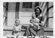
Photograph shows a young woman sitting on a porch step holding a baby. A toddler sits on the step to her right.
Notes
Writing on the front of photograph reads: Doreen Rouse Pachel, Yorkton. Writing on the back of photograph reads: Doreen Rouse Pachel with (Billy & Murray)
Name Access
Doreen Rouse Pachel
Subject Access
family portraits
children
women
Storage Location
RG 5 photograph storage drawer
Images
Show Less

Parade on 10th Street

http://archives.brandonu.ca/en/permalink/descriptions14253
Part Of
Joseph H. Hughes collection
Description Level
Item
GMD
graphic
Date Range
1924
Accession Number
3-1997
Part Of
Joseph H. Hughes collection
Creator
Photographer: C.J. Smith
Description Level
Item
Series Number
3-1997.1
Item Number
3-1997.1.62
Accession Number
3-1997
Other Numbers
Hughes #63
GMD
graphic
Date Range
1924
Physical Description
7.5" x 9.5" (b/w)
Material Details
on matting
Physical Condition
Mat is scuffed
History / Biographical
The Brandon Daily Sun (26 May 1924, 16) reported the annual church parade of Brandon Lodge 173 Sons of England was held on Sunday, May 25, 1924. The Brandon City Band lead the parade with H.J. Barter, P.P., serving as parade marshal. Over 100 members paraded to St. Mary's Church. Representatives from a variety of lodges participated, including Alexander, Neepawa, Souris, Wawanesa, and Lodge Carpenter Juveniles.
Scope and Content
Photograph shows a parade travelling southwards on 10th Street between Rosser and Princess Avenues. A mounted rider wearing white appears to be leading the parade. A car draped with American and British flags follows. A band follows the vehicle. Individuals wearing white hats walk up the street. Business visible on the west side (100-block) of 10th Street include: Doig, Rankin, & Robertson, Limited; Bowling Alley, Billiards; Olympia Cafe Candies. The second storey on the Hughes Building has not been erected. The Alexandra Block, Strathcona Block, Olympia Block are visible. A large Union Jack flys from the Canadian Pacific Station. Vehicles are diagonally parked on both sides of 10th Street.
Notes
Back of photograph is stamped: Hughes & Co. Ltd., 1009 Princess Ave., Brandon, Man. Date for photograph obtained from licence plates.
Name Access
Doig, Rankin & Robertson
Olympia Cafe
Hughes Building
Alexandra Block
Strathcona Block
10th Street
Subject Access
parades
Brandon business buildings & facilities before 1940
cafes
street scenes
Storage Location
Hughes oversize drawer
Images
Show Less

Hughes & Co. Lumber, founding members

http://archives.brandonu.ca/en/permalink/descriptions14254
Part Of
Joseph H. Hughes collection
Description Level
Item
GMD
graphic
Date Range
[1900s]
Accession Number
3-1997
Part Of
Joseph H. Hughes collection
Description Level
Item
Series Number
3-1997.1
Item Number
3-1997.1.63
Accession Number
3-1997
Other Numbers
Hughes #56
GMD
graphic
Date Range
[1900s]
Physical Description
9.5" x 7.5" (b/w)
Material Details
on matting
Physical Condition
Mat is water stained.
Scope and Content
Photograph shows a group of 10 men wearing heavy coats posing in front of Hughes & Co. Lumber located at 152 10th Street.
Notes
Back of photograph is stamped: Hughes & Co. Ltd., 1009 Princess Ave., Brandon, Man. Writing on the back of the photograph reads: Founders of Hughes
Name Access
Hughes & Co. Lumber
Subject Access
Brandon business buildings & facilities before 1940
street scenes
portraits
Storage Location
Hughes oversize drawer
Images
Show Less

Strathcona Block, H.Lamontagne & Co.

http://archives.brandonu.ca/en/permalink/descriptions14255
Part Of
Joseph H. Hughes collection
Description Level
Item
GMD
graphic
Date Range
1905
Accession Number
3-1997
Part Of
Joseph H. Hughes collection
Creator
Photographer: Frank Gowen, Brandon
Description Level
Item
Series Number
3-1997.1
Item Number
3-1997.1.64
Accession Number
3-1997
Other Numbers
Hughes #64
GMD
graphic
Date Range
1905
Physical Description
7.5" x 9.5" (b/w)
Material Details
on matting
Physical Condition
Mat is water stained, emulsive side is stained
Scope and Content
Photograph shows the recently constructed Strathcona Block. H. Lamontagne & Co. Ltd., Wholesale, occupies the ground floor. Scaffolding is suspended from the north side of the building. Buildings have yet to be erected to the north and south sides of the Strathcona Block.
Notes
Back of photograph is stamped: Hughes & Co. Ltd., 1009 Princess Ave., Brandon, Man.
Name Access
Strathcona Block
H. Lamontange & Co.
Subject Access
Brandon business buildings & facilities before 1940
street scenes
portraits
Storage Location
Hughes oversize drawer
Images
Show Less

Wheat City Business College Hockey Club

http://archives.brandonu.ca/en/permalink/descriptions14267
Part Of
Joseph H. Hughes collection
Description Level
Item
GMD
graphic
Date Range
1912
Accession Number
3-1997
Part Of
Joseph H. Hughes collection
Description Level
Item
Series Number
3-1997.1
Item Number
3-1997.1.69
Accession Number
3-1997
Other Numbers
Hughes #67
GMD
graphic
Date Range
1912
Physical Description
9.25" x 7.25" (b/w)
Material Details
on matting
Physical Condition
Photograph is water stained
Scope and Content
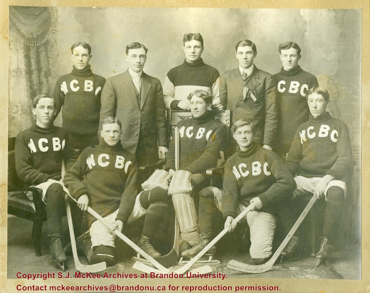
Photograph shows a group of 10 men, eight whom are wearing sweaters with the letters WCBC appliqued across the chest. The goalie is seated in a wodden chair and wears his goalie pads and skates. The four other players in the front row are also wearing skates and have their hockey sticks.
Notes
Writing on the front of the photograph mat reads: Wheat City Business College Hockey Club, 1912
Name Access
Wheat City Business College
Subject Access
portraits
Hockey
sports people & activities
team sports
team photos
Storage Location
Hughes oversize drawer
Images
Show Less

Aerial view: Brandon College

http://archives.brandonu.ca/en/permalink/descriptions594
Part Of
Brandon University Photograph collection
Description Level
Item
GMD
graphic
Date Range
[fall 1964?]
Part Of
Brandon University Photograph collection
Description Level
Item
Series Number
2.1
Item Number
BUPC 2.1.2
GMD
graphic
Date Range
[fall 1964?]
Physical Description
5" x 4" (b/w)
Scope and Content
Brandon College looking south from 19th Street. Photograph was taken after Flora Cowan Hall was built but before construction of the Education Building.
Subject Access
aerial photographs
campus photographs
campus buildings
Brandon streets
Images
Show Less

Aerial view - Brandon College looking southwest

http://archives.brandonu.ca/en/permalink/descriptions601
Part Of
Brandon University Photograph collection
Description Level
Item
GMD
graphic
Date Range
[1963-1966]
Part Of
Brandon University Photograph collection
Description Level
Item
Series Number
2.1
Item Number
BUPC 2.1.8
GMD
graphic
Date Range
[1963-1966]
Physical Description
5" x 4" (b/w)
Scope and Content
Image shows the Brandon College campus from 17th Street looking southwest. The photo was taken after the completion of the original Music Building in 1963, but construction of the Education Building. Also visible are a number of properties on the 200 block of 18th Street and the 200 block of 20th Street.
Subject Access
aerial photographs
campus photographs
campus buildings
Brandon streets
Images
Show Less

20 records – page 1 of 1.