Introduction
Information on archaeological materials in this locale first came to the attention of Dr. Nicholson through Doug Jackson, a local artifact collector from Souris. Doug had observed archaeological materials that included bone, ceramics and lithic material that had been exposed by municipal road building activity, northwest of Lauder Manitoba
Environment
The Makotchi-Ded Dontipi locale is located among stabilized sand dunes in the Lauder Sandhills in Southwestern Manitoba, northwest of the village of Lauder. The area is a mosaic of medium grass prairie and copses of aspen poplar and aspen-oak, together with intermittent sedge grass marshes and small ponds. These wetlands are bordered with balsam poplar, water birch, willows and red osier dogwood.
The well-drained upland forest also contains saskatoon, chokecherry, wild current, hazelnut bushes and occasional wild plums. Lowland areas have nannyberries and high-bush cranberry. Wild strawberries grow in lightly shaded areas along trail margins and in open patches in aspen forest.
History of Excavations
The Makotchi-Ded Dontipi locale is a virtual "island" of forest and marshlands in a vast expanse of mixed grass prairie. This archaeologically and environmentally rich area was given the Dakota name Makotchi-Ded Dontipi, meaning "the place where we live".
Summation
Prior to European settlement, the area was a rich environment for hunter-gatherer people. Archaeological investigations from 1992 to 2002 have revealed numerous sites within the locale. Some of these sites have been extensively excavated while others have been identified or tested.
Seven sites that have been identified in this locale range in age from the historic through protohistoric periods and extend into the middle precontact period. The major sites are the initial Middle Missouri Duthie site, the late precontact Jackson, Bradshaw sites and the protohistoric Twin Fawns, Schuddemat and Hollow B sites. The multi-component Vera site includes historic Métis, late precontact Vickers Focus, and middle precontact Besant, Pelican Lake, McKean Complex and Oxbow occupations. Over 230 units were excavated as well as numerous test pits and several extensive surveys.
Scope and Content
Scope and Content
The Series has been divided into seven sub-series, including (1) Duthie site (2) Jackson site (3) Twin Fawns site (4) Vera site (5) Schuddemat site (6) Bradshaw site (7) Hollow B site.
The Duthie site is the first site identified in the Makotchi-Ded Dontipi locale. It was reported to Dr. Bev Nicholson by Doug Jackson, a local collector who had observed archaeological materials that had been exposed during the construction of Maple Hill Road northwest of Lauder. The site is named after the landowner, Randy Duthie.
The initial inspection of the exposed materials indicated that the eastern half of the site had been severely impacted by raising a road grade using an elevating grader. However, an undetermined amount of the site remained to the west, flanked by a low sand dune. Testing and preliminary excavations were conducted in 1992-93. In 1994 a field school added to the excavated sample. The undisturbed portion of the site, west of Maple Hill Road was situated at the base of a low sand dune and had an aspen and willow forest cover. The water table was approximately one meter below surface at the time of excavation. A rising water table has since prevented further excavations.
Two dates on bone collagen were obtained during excavations. These were 880+/-80 B.P. (Beta 62705) and 970+/-40 B.P. cal. 1030 A.D. (TO 13366). These dates are consistent with an Initial Middle Missouri cultural assignment. The site occupation is identified by the distinctive ceramics found there. Ceramics at the Duthie Site are tool impressed with incising and lip modeling with fabric impressions on most vessels. Jill Taylor analysed the ceramics from the site for a Specialist thesis, Brandon University (1994) and a Masters of Arts degree from the University of Saskatchewan. (Taylor 1995).
Analysis of residue from Duthie site pottery by Matthew Boyd recovered corn (Zea mays) phytoliths and bean (Phaseolus sp.) starch grains indicating consumption of these domesticates at the Duthie site. (Boyd 2006)
The occupation of this site indicates a migration of people from the south who were well acquainted with horticultural farming. These people had previously migrated to South Dakota following river valleys into the central plains from the eastern woodlands during late Hopewell times. It appears that they later migrated well to the north into southern Manitoba but there is no evidence that they remained there for more than a single year.
Boyd, M., C. Surette and B.A. Nicholson. 2006 Archaeobotanical Evidence of Prehistoric Maize (Zea mays) Consumption at the Northern Edge of the Great Plains. Journal of Archaeological Science 33: 1129-1140.
Taylor, J. 1994 An analysis of the ceramics recovered during 1992 and 1993 at the Precontact Duthie Site (DiMe-16). Specialist thesis, Brandon University.
Scope and Content
The Series has been divided into seven sub-series, including (1) Duthie site (2) Jackson site (3) Twin Fawns site (4) Vera site (5) Schuddemat site (6) Bradshaw site (7) Hollow B site.
Field journals have been scanned in multi-page PDF files.
History / Biographical
The Crepeele site was excavated in 2003 as Crepeele 3. Standard archaeological methods were used to excavate the units. Excavation units were initially numbered as units 10, 11, 12 & 13. These numbers have been changed on the catalogue to XU 110 – 113, due to duplication in 2005. Corresponding documents have been changed to reflect the amended excavation unit numbers, however the field journals may contain the initial numbers.
Scope and Content
Record of daily observations at the site including: excavation methods, items recovered, features, local environment and weather.
This record group was artifically created in January 2007 by Tom Mitchell and Christy Henry of the McKee Archives.
Scope and Content
The record group consists of various fonds and collections concerned with the political, cultural, social, and educational life of western Manitoba. See the Subject Access field for a list of titles.
Brandon University 77th convocation AM (May 28, 1988)
88-BUC-80A
Time: 62:00
tape end - Pres. and Chancellor standing (back to camera) ready to greet class of 38/48 - audio applause to fade - video 10 to 15 sec. overlap
Storage Location
Brandon University photograph collection
Series 13: Videos
Related Material
Morris Predinchuck series (convocation photographs) in the Brandon University photograph collection.
Joseph Henry Hughes was born in London, Ontario on April 14, 1857, son of Joseph C. Hughes and Jane McAndless. His family farmed in Middlesex County until they retired to Brandon, MB. Huges received his education in Middlesex County then went on to attend the Toronto Normal School in 1874. He tuaght for only a short time in 1875 before going into business as a general merchant in Iderton, Ontario.
Hughes moved to Brandon, MB in 1882 and from 1882 to 1906 was engaged in the lumber business with yards in Rat Portage and Brandon and later with mils on Rainy River. His buisness partner was T.H. Patrick from 1882-1896. T.T. Atkinson was a partner in the business from 1882 until early 1888, running the company's lumber camp in the Rainy River Valley. Atkinson was replaced by a Mr. Kennedy in 1888. After disposing of the mills in 1901, Hughes & Company operated as a lumber dealer until 1908 when the lumber business was sold to Rat Portage Lumber Co., whose operations in Brandon were located on 10th Street between Rosser and Princess Avenues.
Thereafter, Hughes & Company focused on real estate, owning most of the property between 10th and 11th Streets, Rosser and Princess Avenues. The company built rental property and residences in Brandon, including the Strathcona Block on 10th Street and Hughes (Lorne) Terrace on Lorne Avenue. During this period Hughes & Company was also involved in insurance and farming, buying farmland in south eastern Saskatchewan and Manitoba for lease and sale.
Hughes was a city alderman for four years, dedicating himself mostly towards improvements to the city pertaining to electrical generation, water supply and the development of the streetcar franchise. In 1911, he resigned from City Council to stand as a successful candidate for mayor. He held this position for only one year, 1913-1914. During this period Hughes, along with other prominent citizens, set up the Patriotic Fund to help look after the dependents of those going off to fight in World War I. Hughes served as chairman of the project until his death in late 1917.
In addition to his role as a prominent city businessman, Hughes was also deeply involved in the First Methodist Church, and a member of the Independent Order of OddFellows (I.O.O.F.) and the Masonic Lodge.
Joseph Henry Hughes was survived by his wife Anna Maria Hughes, whom he married in 1993, and their daughters: Alma and May (Mrs. Wilfred C. Hughes and Mrs. Charles Leemnnis) and Ruth, and their sons Percy and Harley.
Upon J.H. Hughes' death in 1917, management of the company was taken over by Willard C. Hughes, who died in 1964. Following his death the company was administered on behalf of Alma Hughes by Barry Hughes, a Winnipeg lawyer and distant relative. The company remained active in real estate and property managment, as well as farming and oil, until the early 1990s when following the death of Alma Hughes and her daughter Anna, the company was liquidated.
Custodial History
The records in the Joseph H. Hughes fonds were held in two locations prior to their donation to the McKee Archives. Family related records, including paintings by Anna Hughes, music scores, photographs and various parchments, were stored at the family residence, Lorne Terrace (133-137 Lorne Avenue Brandon, MB). The balance of the records, being the records of Hughes & Co. as the firm came to be known, were stored on the fourth floor of the Alexander Block, also known as the Hughes Block, on the west side of 10th Street just south of Princess Avenue. In the early 1990s a decision was taken by Barry Hughes, who had succeeded Willard Hughes as the President of the company, to sell Hughes & Co. Hughes directed Joe Perry, the Brandon manager of Hughes & Co. to donate the records of the Hughes family and Hughes & Co. to Brandon Univeristy. Perry supervised the transfer of the records from Lorne Terrace and the Alexander Block to Brandon University. Initially the records were located in the Physical Plant H-Hut, they were then transfered to the Brandon University Steam Plant. The family records were transfered to the Archives in 1997, while the company records remained in the Steam Plant until January 2007 when some of the records were transfered to the Archives. The remaineder of the records were moved to a storage facility on 20th Street.
Scope and Content
The Joseph H. Hughes collection is divided into three series, including: (1) Photographs; (2) Edwardian music sheets; and (3) Hughes & Co. business records.
Notes
CAIN No. 202617. The Brandon Sun, August 6th, 1917 contains a report on the death of J.H. Hughes.
The Brandon Art Club was founded in November 1907, and operated in an art studio on the top floor of the Brandon College Women's Residence. The club appears to have been the creation of Miss. H. Hancock, who became the Director of the Department of Art at Brandon College c. 1907. The club moved to larger facilities made available at the First Methodist Church; the organization remained there until sometime during the Great War when the club relocated to St. Paul's Presbyterian Church and then in 1921, to the Prince Edward Hotel. The club's first public art exhibitions were held at the Prince Edward Hotel. Art classes were held for the first time in 1928. In 1968, the Brandon Art Club merged with the Allied Arts Center, which had been formed in 1959. The Allied Arts Center was located at 1036 Louise Avenue. In April 1984, the Allied Arts Center was moved to new facilities at the Arts Center of Western Manitoba located at 638 Princess Avenue. In 1989, it was renamed the Art Gallery of Southwestern Manitoba, and began to function as a "professional, regional art gallery." The Art Gallery of Southwestern Manitoba relocated to 2-710 Rosser Ave. c. 2001.
Custodial History
These records were created at different times between 1907 and 1993, and remained in the possession of the administration of the above mentioned organizations until May 2001, when they where donated to the McKee Archives.
Scope and Content
Fonds contains administrative records, minutes, personal files, correspondence, newsletters, photographs, summaries of collections and exhibits, scrapbooks, programs, submitted papers, and other miscellaneous records. All are a record of the growth and evolution of the Art Club, its administration, and of the art community in Brandon.
The A.E. McKenzie Company fonds (RG 3 MG 1, 1.3) located in the McKee Archives contains some records, primarily correspondence and minutes, relating to the Brandon Allied Arts Council.
Field journals have been scanned in multi-page PDF files. Artifact catalogues are PDF files in spreadsheet format. Photographs are in jpeg format.
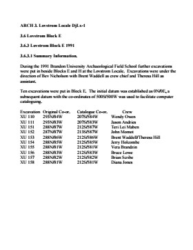
History / Biographical
Excavations took place in block E in 1987 and 1988 with 21 units opened. Ten further units were excavated in 1991 as part of the Brandon University Archaeological Field School, directed by Dr. Nicholson with Brett Waddell as crew chief and Theresa Hill as field assistant.
In 1991 a hearth was identified in Block E as well as a cluster of spoil dirt piles believed to represent material from a pit feature identified in the 1988 excavations. The pit feature is believed to be related to the recovery of clay that may have been used to build ceramic vessels.
Stratigraphic evidence of distinct activity areas at successive depths and radiocarbon dates indicate at least three occupations (380 BP, 700 BP and 860 B P). Three identified activity clusters occur stratigraphically, supporting these dated occupations.
Large numbers of lithics were recovered, forming an assemblage dominated by SRC and KRF with lesser amounts of porcellanite and quartzite. The upper occupation contained some Tongue River Silicified Sediment (TRSS). Eight Prairie Side-Notched points were recovered as well as a lunate biface and an end scraper. Fragments from a grey soapstone tube were also recovered.
Scope and Content
Sub-sub-sub series contains: Summary information of field methology, number and co-ordinates of excavations, personnel and their staff position; Field journals are daily records of recoveries, features and activities at the site; Site records include excavation level and unit summaries, feature sheets, profiles; sample records and maps; Artifact catalogues are lists and identifications of all artifacts recovered; Photographs are of excavation units, features, the landscape and personnel.
Field journals have been scanned in multi-page PDF files. Artifact catalogues are PDF files in spreadsheet format. Photographs are in jpeg format.
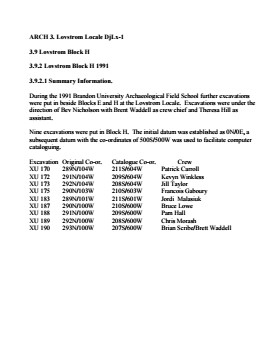
History / Biographical
Large scale excavations of two block sites took place in 1988 under the direction of Bev Nicholson with Brett Waddell as crew chief and Theresa Hill as assistant. Block E consisted of 10 additional excavation units.
Scope and Content
Sub-sub-sub series contains: Summary information of field methology, number and co-ordinates of excavations, personnel and their staff position.
Field journals have been scanned in multi-page PDF files. Artifact catalogues are PDF files in spreadsheet format. Photographs are in jpeg format.
History / Biographical
Based on the recoveries at the Block H in 1988, further excavations took place in 1991. Nine excavation units were opened next to the previous excavations. Another 250 ceramic sherds were recovered in 1991. Nine vessels have been identified based on rim sherds. Vickers Focus and Woodland vessels have been identified and two vessels similar to Scattered Village Complex were recovered.
The lithic material assemblage is intermediate primarily KRF followed by local cherts. Two features, a hearth and a curvilinear arrangement of rock were recovered during the 1991 excavations.
The high numbers of ceramic fragments suggests a habitation area, rather than hunting or butchering behavior. However, the separation of occupations at the site is difficult to establish and there may be different uses of the site by successive occupations.
Scope and Content
Sub-sub-sub series contains: Summary information of field methology, number and co-ordinates of excavations, personnel and their staff position; Field journals are daily records of recoveries, features and activities at the site; Site records include excavation level and unit summaries, feature sheets, profiles; sample records and maps; Artifact catalogues are lists and identifications of all artifacts recovered; Photographs are of excavation units, features, the landscape and personnel.
Field journals have been scanned in multi-page PDF files. Artifact catalogues are PDF files in spreadsheet format. Photographs are in jpeg format.
History / Biographical
Large scale excavations of two block sites took place in 1988 under the direction of Bev Nicholson with Brett Waddell as crew chief and Theresa Hill as assistant. Block H consisted of nine additional excavation units.
Scope and Content
Sub-sub-sub series contains: Summary information of field methology, number and co-ordinates of excavations, personnel and their staff position.
Margaret Menzies was born on July 30th, 1920, at a family farm located in Oakburn, Manitoba. She grew up on the family farm and attended school in both Oakburn and Shoal Lake. She married Donald Menzies on June 4th, 1941. Together they had four children. In 1959, the family moved to Brandon, Manitoba, where they lived for the rest of their lives.
Margaret Menzies was a longtime and active member of the International Toastmistress Club (ITC), and was also involved in the Consumers Association of Canada, Seniors for Seniors, as well as being a member of the Liberal Party of Canada and the Central United Church. Menzies did not graduate from high school in her early years, but managed to continue her education and receive a bachelor of arts degree from Brandon University at the age of 70.
Margaret Menzies passed away on June 9th, 2012.
Custodial History
Records in the collection were brought to the S.J McKee Archives on July 13, 2012, by Gerald Brown, on behalf of the family of Margaret Menzies.
Scope and Content
Collection contains of two scrapbooks created by Margaret Menzies. The scrapbooks contain various cards, itinerary's, and other documents associated with Menzies' membership in the International Toastmistress Club. The items in the scrapbooks date from the mid 1980's to the late 1990's.
Also included in the collection are four local history books. The first is a 100 year history of the town of Oakburn, Manitoba, from 1870 to 1970, published during celebrations of Manitoba's centenniary in 1970. Next is a book about the history of the town of Shoal Lake, Manitoba, which was published in 1959 on the 50th anniversary of the founding of the town of Shoal Lake in 1909. The last two books are the first and second volumes of Ripples on the Lake, which cover the history of the Shoal Lake municipality from 1884. The first volume covers the first 100 years of the history of the Shoal Lake region, being published in 1984. The second volume was published in 2007, covering the history of Shoal Lake since 1984, as well as including new information that was not published in the 1984 version of the book.
Finally, the collection contains one photograph of Margaret Menzies receiving her bachelor of arts degree from Peter Hordern, dean of arts of Brandon University.
Notes
Biographical information provided by obituary entry in the Brandon Sun, June 16, 2012. Description by Tyler Warren (October 2012).
Cover of Young School minute book is moderately damaged, but pages are in good condition with only minor water damage and a few ripped pages.
History / Biographical
Dorothy Cox (nee Frost) moved from Elm Creek to Justice in 1946 to work as a schoolteacher. In 1948, she married Laval Cox and together they had four children: Larry, Herd, Rosalie and Heather.
In 1949, Dorothy and Laval purchased Gibb Gillespie's PSV business and began hauling grain, cattle and agricultural equipment. Dorothy went back to teaching in 1959, first at Justice and then Elton Collegiate. After retiring from teaching in 1978, Dorothy started a greenhouse, which operated for 21 years.
All six members of the Cox family were active in community events and organizations. Dorothy was involved in establishing the baby band in 1951; her sons Larry and Herb were members. Along with Laval, Dorothy was a leader of the Cubs in 1955-1956 and again in 1958-1959. Laval was the leader of the local hockey club in 1958, and of a bible study group in 1960. Larry, Herb and Rosalie were avid skaters in 1960-64. Heather and Rosalie were enrolled in senior grades of Sunday school in 1970.
Custodial History
Records were collected by Dorothy Cox, a resident of Justice, over a number of years. She donated them to the McKee Archives on April 4, 2012.
Scope and Content
Collection consists of records related to the history of the Justice district. It includes a history of the Justice Church (1910-1970); minute and expense books for the Justice Hockey Club (1949-1966); a minute and expense book for Young Protestant School (1884-1898); a copy of the Justice 100th Anniversary community history (2009); and four color photographs of Justice Church.
Notes
History/Bio information taken from the content of the collection. Description by James Heaman (2012).
Field journals have been scanned in multi-page PDF files. Artifact catalogues are PDF files in spreadsheet format. Photographs are in jpeg format.
History / Biographical
Directed by Dr. Nicholson and with Ian Kuijt as crew chief, fourteen additional units were excavated in Block E in 1988. Stratigraphic evidence of distinct activity areas at successive depths and radiocarbon dates indicate at least three occupations (380 BP, 700 BP and 860 B P).
Three identified activity clusters occur stratigraphically, supporting these dated occupations. A clear distinction between Blackduck and Vickers Focus ceramics is evident in this Block. Sixteen small side-notched and un-notched points were recovered in this excavation series as well as numerous unifacial scrapers. Fragments from a grey soapstone tube were also recovered.
Scope and Content
Sub-sub-sub series contains: Summary information of field methology, number and co-ordinates of excavations, personnel and their staff position; Field journals are daily records of recoveries, features and activities at the site; Site records include excavation level and unit summaries, feature sheets, profiles; sample records and maps; Artifact catalogues are lists and identifications of all artifacts recovered; Photographs are of excavation units, features, the landscape and personnel.
Field journals have been scanned in multi-page PDF files. Artifact catalogues are PDF files in spreadsheet format. Photographs are in jpeg format.
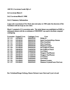
History / Biographical
Large scale excavations of four block sites took place in 1988 under the direction of Bev Nicholson with Ian Kuijt as crew chief. Block E consisted of 14 additional excavation units.
Scope and Content
Sub-sub-sub series contains: Summary information of field methology, number and co-ordinates of excavations, personnel and their staff position.
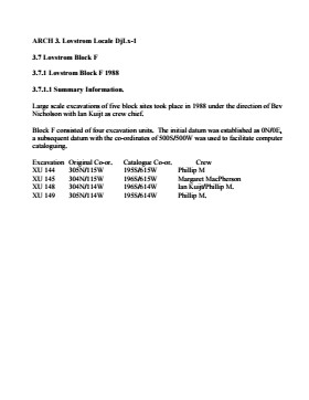
In 1988 four 1m2 units were excavated in this Block F. The forest cover is identical to that of Block E, with an open oak forest with a light understory of saskatoon, hazelnut, poison ivy and sarsaparilla.
Underneath the litter mat (Ah) is a shallow, 15-20 cm “A” horizon of dark grey/brown silty loam with a high representation of pebble size clasts. The glacial clays, encountered at 20 cm below surface, consist of a matrix of light tan sandy clays containing rounded pebble to cobble size rocks.
The recoveries from this block consisted of a few ceramics, including Vickers Focus rim sherds, four lithic tools and a number of small bison bone fragments. There was no discernible cultural stratigraphy in the four 1m2 units and the limited deposits of bone, ceramics and lithics were dispersed randomly throughout the 25 cm of cultural matrix. The lithic materials frequencies were similar to those in Block E with local cherts and KRF being the most abundant categories. A small amount of fire-cracked rock and a few large identifiable bison bones were recovered – all distributed randomly with little evidence for any pattern of clustering.
No RC dates.
Scope and Content
Sub-sub-sub series contains: Summary information of field methology, number and co-ordinates of excavations, personnel and their staff position; Field journals are daily records of recoveries, features and activities at the site; Site records include excavation level and unit summaries, feature sheets, profiles; sample records and maps; Artifact catalogues are lists and identifications of all artifacts recovered; Photographs are of excavation units, features, the landscape and personnel.
Field journals have been scanned in multi-page PDF files. Artifact catalogues are PDF files in spreadsheet format. Photographs are in jpeg format.
History / Biographical
Large scale excavations of four block sites took place in 1988 under the direction of Bev Nicholson with Ian Kuijt as crew chief. Block F consisted of 4 excavation units.
Scope and Content
Sub-sub-sub series contains: Summary information of field methology, number and co-ordinates of excavations, personnel and their staff position.
In 1988 four units were excavated in Block G. The vegetation is similar to other areas in the locale with an open oak forest with a light understory of saskatoon, hazelnut, poison ivy and sarsaparilla.
Excavations recovered artifacts between 0 cm – 15 cm b.s. The cultural deposits are very shallow and it is quite possible that what appears to be a single occupation may in fact represent multiple occupation compressed deposits as a result of deflation or the lack of sedimentation in this raised area. This latter view is supported by the ceramics which appear to be a mixture of Blackduck and Vickers Focus wares.
The frequency and distribution of cultural material from block G contrasts with that of other sites in the locale. While the diagnostic materials are similar, the nature of the background debris and the associated lithic assemblage suggests that this area was utilized for a different set of activities.
Unlike Blocks E and H, there is very little in the way of ceramics, fire-cracked rock or bison bone, yet a significant amount of lithic debitage and six Plains/Prairie Side-notched projectile points were recovered. No unifaces or scrapers were recovered. This may be an area where activities such as manufacture and hafting of projectile points; hunting activities, butchering and refuse disposal took place.
No RC dates were taken.
Scope and Content
Sub-sub-sub series contains: Summary information of field methology, number and co-ordinates of excavations, personnel and their staff position; Field journals are daily records of recoveries, features and activities at the site; Site records include excavation level and unit summaries, feature sheets, profiles; sample records and maps; Artifact catalogues are lists and identifications of all artifacts recovered; Photographs are of excavation units, features, the landscape and personnel.
Field journals have been scanned in multi-page PDF files. Artifact catalogues are PDF files in spreadsheet format. Photographs are in jpeg format.
History / Biographical
Large scale excavations of four block sites took place in 1988 under the direction of Bev Nicholson with Ian Kuijt as crew chief. Block G consisted of 4 excavation units.
Scope and Content
Sub-sub-sub series contains: Summary information of field methology, number and co-ordinates of excavations, personnel and their staff position.
The vegetation in block H is similar to other areas in the locale with an open oak forest with a light understory of saskatoon, hazelnut, poison ivy and sarsaparilla.
The excavations of the eight 1m2 units in 1988 resulted in the recovery of over 650 ceramic fragments including 20 rim sherds from at least four vessels, a grooved maul, fire-cracked rock, lithic debitage and a reworked Avonlea projectile point. A large amount of bison bone, including a number of axial elements and a fragmented skull were also recovered.
Based on the 1988 recoveries at the site further excavations took place in 1991. Nine excavation units were opened next to the previous excavations. Another 250 ceramic sherds were recovered in 1991. Nine vessels have been identified based on rim sherds. Vickers Focus and Woodland vessels have been identified and two vessels similar to Scattered Village Complex were recovered.
The lithic material assemblage is intermediate between Blocks G and E with KRF being the most frequent material category followed by local cherts.
Two features, a hearth and a curvilinear arrangement of rock were recovered. The high numbers of ceramic fragments suggests a habitation area, rather than hunting or butchering behavior. However, the separation of occupations at the site is difficult to establish and there may be different uses of the site by successive occupations.
Radiocarbon dates from this block indicate two occupations separated in time by some 300 years. XU 181 – 405/110 BP and XU 184 – 780/110 BP.
Scope and Content
Sub-series has been divided into sub sub series including: Lovstrom Block H 1988 and Lovstrom Block H 1991.