Skip header and navigation

Revise Search

23 records – page 1 of 2.

Part Of
RG 11 Lawrence Stuckey fonds
Description Level
Item
GMD
graphic
Date Range
[ca. 1912]
Accession Number
1-2002
Part Of
RG 11 Lawrence Stuckey fonds
Description Level
Item
Series Number
3.1
Item Number
1-2002.3.1N5
Accession Number
1-2002
GMD
graphic
Date Range
[ca. 1912]
Physical Description
3 1/2" x 5"
Material Details
Negative
Custodial History
For custodial history see the collection level description of the Lawrence Stuckey collection.
Scope and Content
Stanley Park from old PC.
Notes
Shows bandstand
[By "PC" Mr. Stuckey likely meant to indicate Park School (built 1904, demolished 1978). Park School was, at the time the photo was taken, located directly across Lorne Avenue from Stanley Park. P.E. 22/07/09]
Name Access
Stanley Park
Subject Access
parks
Brandon Miscellaneous History
Repro Restriction
The McKee Archives is the copyright holder for the Stuckey materials.
Storage Location
Lawrence Stuckey collection
Images
Show Less

John Indian's Bush

http://archives.brandonu.ca/en/permalink/descriptions9869
Part Of
RG 11 Lawrence Stuckey fonds
Description Level
Item
GMD
graphic
Date Range
July 18, 1978
Accession Number
1-2002
Part Of
RG 11 Lawrence Stuckey fonds
Creator
L.A. Stuckey
Description Level
Item
Series Number
3.1
Item Number
1-2002.3.1NA4(1)
Accession Number
1-2002
GMD
graphic
Date Range
July 18, 1978
Physical Description
2 1/2" x 2 1/2"
Material Details
Negative
History / Biographical
This wedge-shaped tract of woodland was located west of 34th Street on the south side of the Canadian Pacific Railway. It was formerly owned by the Great Northern Railway, and was acquired by the CPR when the GN line was abandoned in 1936. In 1978 Marathon Realty (CPR) sold this 7 acre property to a developer who planned to build condominiums. However this residential development was objected to for two reasons: [The proposed location] was home to many species of flora & fauna, and it was too close to the CPR mainline. Local residents took out a petition against the development. [Mr. Stuckey] wrote a letter to the editor of the Brandon Sun, [expressing the] attitudes of CPR officials, and read a statement to the Provincial Planning Board suggesting development be refused and the area become an undeveloped park. These efforts would prove successful - see file on same.
Custodial History
For custodial history see the collection level description of the Lawrence Stuckey collection.
Scope and Content
John Indian's Bush (also known as Bang's Bush)
Notes
Additional historical information provided by the Fred McGuinness collection (20-2009). Stuckey's letter to the editor appears in the July 22, 1978 issue of The Brandon Sun.
Name Access
John Indian's Bush
Bang's Bush
Subject Access
parks
Brandon Miscellaneous History
Repro Restriction
The McKee Archives is the copyright holder for the Stuckey materials.
Storage Location
Lawrence Stuckey collection
Arrangement
[Mr. Stuckey had put two negatives in the same envelope. They are now separated as NA4(1) and NA4(2).]
Images
Show Less

John Indian's Bush

http://archives.brandonu.ca/en/permalink/descriptions9870
Part Of
RG 11 Lawrence Stuckey fonds
Description Level
Item
GMD
graphic
Date Range
July 18, 1978
Accession Number
1-2002
Part Of
RG 11 Lawrence Stuckey fonds
Creator
L.A. Stuckey
Description Level
Item
Series Number
3.1
Item Number
1-2002.3.1NA4(2)
Accession Number
1-2002
GMD
graphic
Date Range
July 18, 1978
Physical Description
2 1/2" x 2 1/2"
Material Details
Negative
History / Biographical
This wedge-shaped tract of woodland was located west of 34th Street on the south side of the Canadian Pacific Railway. It was formerly owned by the Great Northern Railway, and was acquired by the CPR when the GN line was abandoned in 1936. In 1978 Marathon Realty (CPR) sold this 7 acre property to a developer who planned to build condominiums. However this residential development was objected to for two reasons: [The proposed location] was home to many species of flora & fauna, and it was too close to the CPR mainline. Local residents took out a petition against the development. [Mr. Stuckey] wrote a letter to the editor of the Brandon Sun, [expressed the] attitudes of CPR officials, and read a statement to the provincial planning board suggesting development be refused and the area become an undeveloped park. These efforts would prove successful - see file on same.
Custodial History
For custodial history see the collection level description of the Lawrence Stuckey collection.
Scope and Content
John Indian's Bush (also known as Bang's Bush).
Notes
Additional historical information provided by the Fred McGuinness collection (20-2009). Stuckey's letter to the editor appears in the July 22, 1978 issue of The Brandon Sun.
Name Access
John Indian's Bush
Bang's Bush
Subject Access
parks
Brandon Miscellaneous History
Repro Restriction
The McKee Archives is the copyright holder for the Stuckey materials.
Storage Location
Lawrence Stuckey collection
Arrangement
[Mr. Stuckey had put two negatives in the same envelope. They are now separated as NA4(1) and NA4(2).]
Images
Show Less

Lorne Avenue in winter

http://archives.brandonu.ca/en/permalink/descriptions10114
Part Of
RG 12 Brandon and Area Photograph Collection
Description Level
Item
GMD
graphic
Date Range
c. 1905
Part Of
RG 12 Brandon and Area Photograph Collection
Description Level
Item
Series Number
2
Item Number
BAPC 2.1
GMD
graphic
Date Range
c. 1905
Physical Description
4" x 6" (b/w)
Scope and Content
Photograph is looking east down Lorne Avenue from Brandon College.
Name Access
Lorne Avenue
18th Street
Park School
Subject Access
cityscapes
winter
Storage Location
BAPC photograph drawer
Images
Show Less

Lorne Avenue in summer

http://archives.brandonu.ca/en/permalink/descriptions10115
Part Of
RG 12 Brandon and Area Photograph Collection
Description Level
Item
GMD
graphic
Date Range
c. 1905
Part Of
RG 12 Brandon and Area Photograph Collection
Description Level
Item
Series Number
2
Item Number
BAPC 2.2
GMD
graphic
Date Range
c. 1905
Physical Description
4" x 6" (b/w)
Scope and Content
Photograph is looking east down Lorne Avenue from Brandon College.
Name Access
Lorne Avenue
18th Street
Park School
Subject Access
cityscapes
Storage Location
BAPC photograph drawer
Images
Show Less

Funeral procession on Lorne Avenue

http://archives.brandonu.ca/en/permalink/descriptions10116
Part Of
RG 12 Brandon and Area Photograph Collection
Description Level
Item
GMD
graphic
Date Range
c. 1905
Part Of
RG 12 Brandon and Area Photograph Collection
Description Level
Item
Series Number
2
Item Number
BAPC 2.3
GMD
graphic
Date Range
c. 1905
Physical Description
4" x 6" (b/w)
Scope and Content
Photograph shows a funeral procession travelling west on Lorne Avenue and turning south onto 18th Street in Brandon. The photograph was taken from Brandon College.
Name Access
Lorne Avenue
18th Street
Park School
Subject Access
cityscapes
funerals
Storage Location
BAPC photograph drawer
Images
Show Less

World War I soldiers march down Rosser Avenue

http://archives.brandonu.ca/en/permalink/descriptions10125
Part Of
RG 12 Brandon and Area Photograph Collection
Description Level
Item
GMD
graphic
Date Range
c. 1914
Accession Number
24-1999
Part Of
RG 12 Brandon and Area Photograph Collection
Description Level
Item
Series Number
2
Item Number
BAPC 2.12
Accession Number
24-1999
GMD
graphic
Date Range
c. 1914
Physical Description
7.5" x 9.5" (b/w)
Physical Condition
There are two burn holes and many areas where the emulsion layer is gone.
History / Biographical
John A. McDonald's was a men's and boyswear store in operation for several decades at 841 Rosser Avenue, Brandon, MB.
Scope and Content
Photograph of soldiers marching west on Rosser Avenue.
Name Access
John A. McDonald's
Diamond Hall
W.E. Crawford
The Patricia
World War I
First World War
Great War
Rosser Avenue
Subject Access
public ceremonies
armed forces
military personnel
parades
downtown
cityscapes
Storage Location
BAPC photograph drawer
Images
Show Less

HRH the Duke of Connaught visits Brandon

http://archives.brandonu.ca/en/permalink/descriptions10126
Part Of
RG 12 Brandon and Area Photograph Collection
Description Level
Item
GMD
graphic
Date Range
October 24, 1912
Accession Number
1-2000
Part Of
RG 12 Brandon and Area Photograph Collection
Description Level
Item
Series Number
2
Item Number
BAPC 2.13
Accession Number
1-2000
GMD
graphic
Date Range
October 24, 1912
Physical Description
7.5" x 9.5" (b/w)
Material Details
On matting
Scope and Content
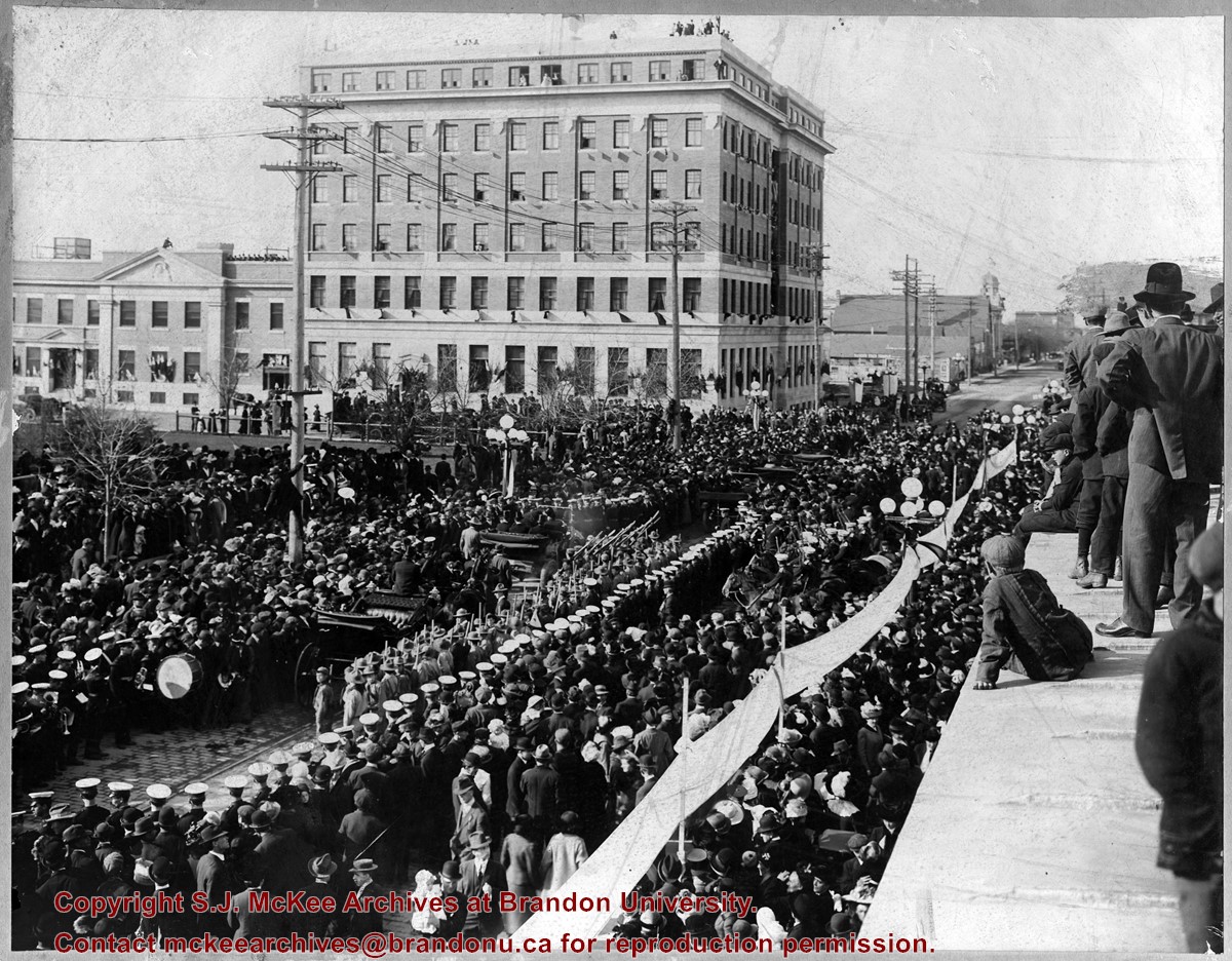
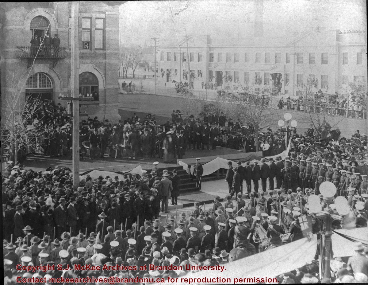
Photograph shows a public reception for the Governor General of Canada, HRH the Duke of Connaught during a visit to Brandon, MB. The reception was held on Princess Avenue at City Hall. The photograph is looking southwest from the north side of Princess Avenue. The building in the background is the recently constructed Prince Edward Hotel.
Name Access
Governor General of Canada
HRH the Duke of Connaught
Princess Avenue
Prince Edward Hotel
9th Street
Subject Access
public ceremonies
downtown
cityscapes
Imperialism
royalty
Storage Location
BAPC oversize storage drawer
Images
Show Less

Thompson's Groceries and Confectionary - exterior

http://archives.brandonu.ca/en/permalink/descriptions10133
Part Of
RG 12 Brandon and Area Photograph Collection
Description Level
Item
GMD
graphic
Date Range
c. 1925
Part Of
RG 12 Brandon and Area Photograph Collection
Description Level
Item
Series Number
2
Item Number
BAPC 2.21
GMD
graphic
Date Range
c. 1925
Physical Description
8" x 10" (b/w)
History / Biographical
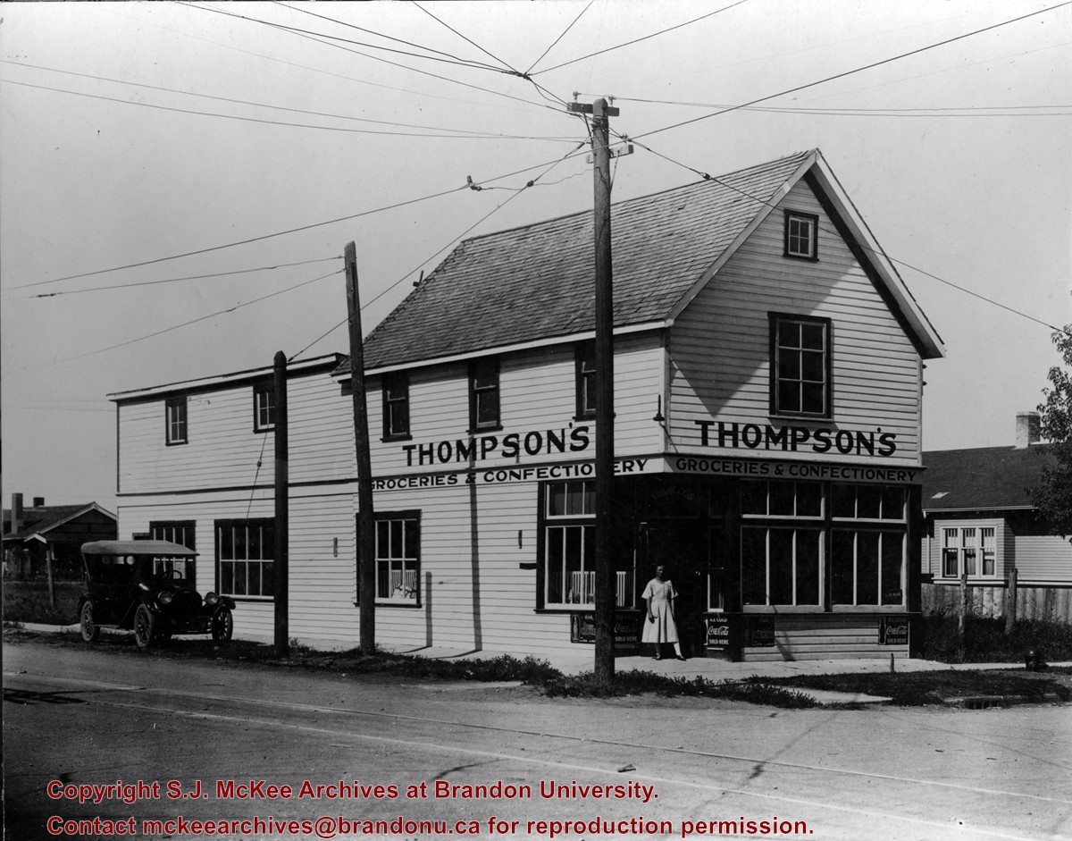
Thompson's Groceries and Confectionary was established in 1923 by Arthur Thompson (b. 1881 - d. May14, 1957) at 764 13th Street. From approximately 1925-1927, the store was operated by Alexander Thompson at 762 13th Street. The fate of the store from 1929-1935 is unclear. In 1929, Alexander Thompson was a grocer at 748 7th Street and in 1931 a Mrs. A Thompson was a grocer at 802 14th Street. There were two Thompson grocery and confectionary businesses in Brandon in 1933: Thompson's Confectionary at 745 13th Street and Thompson & Co. at 702 12th Street. In 1935, Arthur Thompson appears to have either taken over one of the earlier businesses or reopened his own grocery in its original location at 762 13th Street. He operated his store at this location into the mid-1950s. At some point following Thompson's death the building was bought by Frank Fitzpatrick and used for his upholstery store.
Custodial History
Donated by Frank Fitzpatrick.
Scope and Content
Photograph is looking northwest at the extrior of Thompson's Grocieries and Confectionary.
Notes
History/Bio information taken from Henderson's Directories (1917-1955) for Brandon, MB.
Name Access
Thompson's Groceries and Confectionary
13th Street
College Avenue
Subject Access
grocery stores
cityscapes
businesses
stores
Storage Location
BAPC photograph drawer
Images
Show Less

HRH the Duke of Connaught visits Brandon

http://archives.brandonu.ca/en/permalink/descriptions10135
Part Of
RG 12 Brandon and Area Photograph Collection
Description Level
Item
GMD
graphic
Date Range
October 24, 1912
Accession Number
32-2006
Part Of
RG 12 Brandon and Area Photograph Collection
Description Level
Item
Series Number
2
Item Number
BAPC 2.23
Accession Number
32-2006
GMD
graphic
Date Range
October 24, 1912
Physical Description
8" x 10" (b/w)
Physical Condition
There is staining from the top left corner towards the centre of the image.
Custodial History
Jack Stothard purchased the image at a yard sale, location unknown. He donated it to the Archives in 2006.
Scope and Content
Photograph of a public reception for the Governor General of Canada, HRH the Duke of Connaught. The reception was held in fromt of the Brandon City Hall, which was located at 9th Street and Princess Avenue. The photograph is looking south southeast. A portion of the recently constructed Prince Edward Hotel is visible in the background.
Name Access
Governor General of Canada
HRH the Duke of Connaught
Princess Avenue
Prince Edward Hotel
9th Street
City Hall
Subject Access
public ceremonies
downtown
cityscapes
Imperialism
royalty
Storage Location
BAPC photograph drawer
Images
Show Less

Daly 18th Street overpass

http://archives.brandonu.ca/en/permalink/descriptions10139
Part Of
RG 12 Brandon and Area Photograph Collection
Description Level
Item
GMD
graphic
Date Range
[after 1963]
Part Of
RG 12 Brandon and Area Photograph Collection
Description Level
Item
Series Number
2
Item Number
BAPC 2.27
GMD
graphic
Date Range
[after 1963]
Physical Description
5" x 3.5" (b/w)
History / Biographical
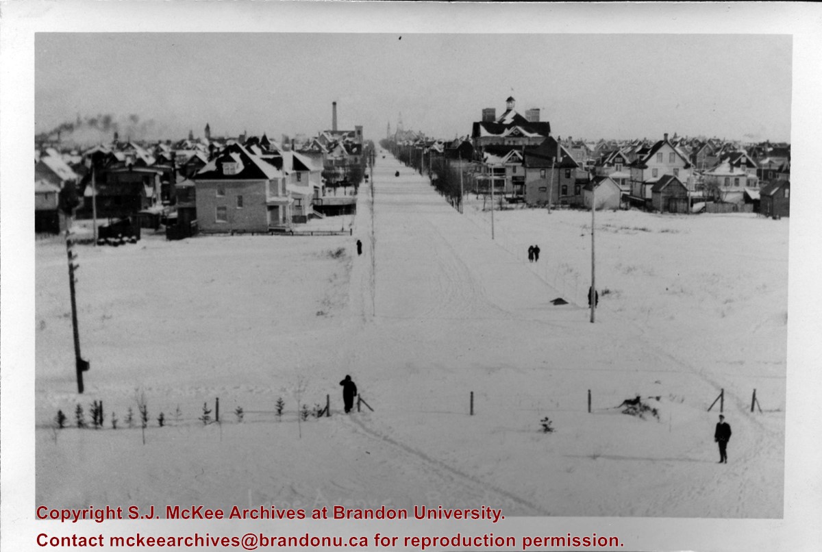
The overpass is named for Brandon's first mayor, Thomas Mayne Daly, and the street on which the overpass is located. The overpass opened in October 1963.
Scope and Content
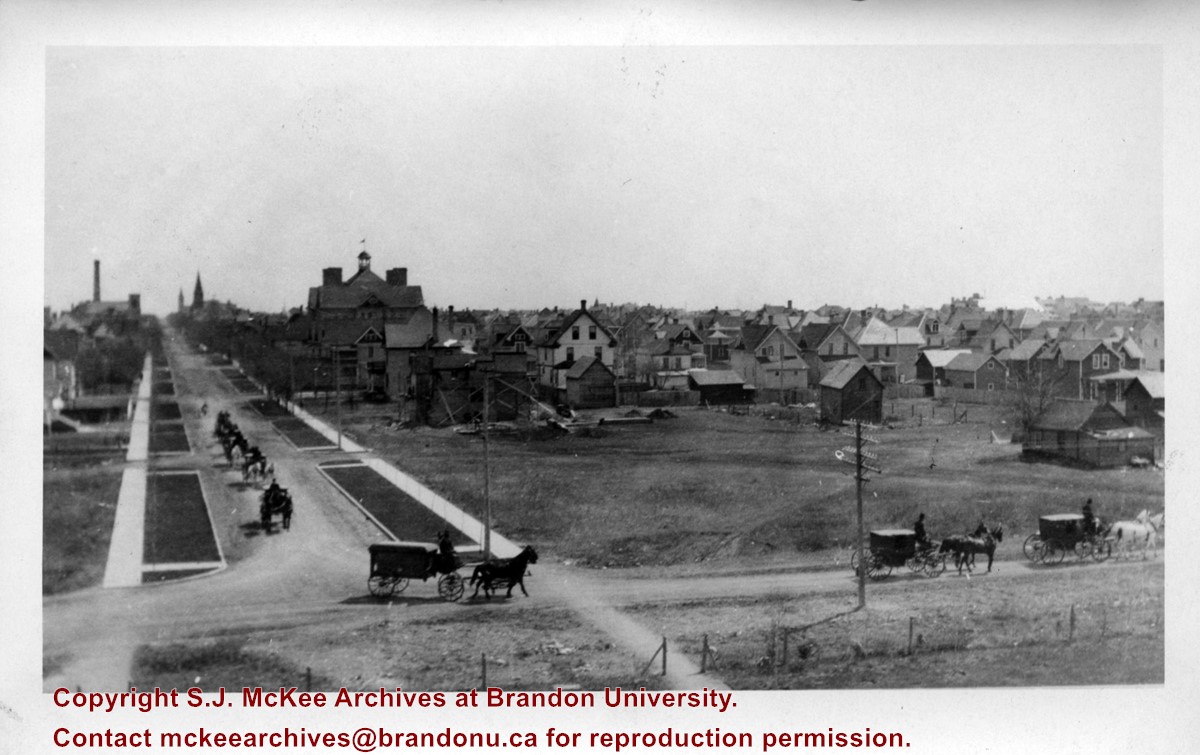
Photograph is an aerial view of the Daly 18th Street Overpass (18th Street Bridge). Visible are a number of commercial and residential buildings in the north end of Brandon, MB. The view is northeast, probably taken from the roof of the old steam plant north of 20th Street and Rosser Avenue.
Name Access
Daly 18th Street Overpass
18th Street Bridge
Kane Equipment Ltd.
International Harvester Company of Canada
Pacific Avenue
Subject Access
northend
bridges
manmade geographic features
cityscapes
Storage Location
BAPC photograph drawer
Images
Show Less

Aerial view: Brandon University campus

http://archives.brandonu.ca/en/permalink/descriptions2576
Part Of
Brandon University Photograph Collection
Description Level
Item
GMD
graphic
Date Range
September 21, 1999
Part Of
Brandon University Photograph Collection
Description Level
Item
Series Number
9
Item Number
BUPC 9.36
GMD
graphic
Date Range
September 21, 1999
Physical Description
11" x 14" (colour)
History / Biographical
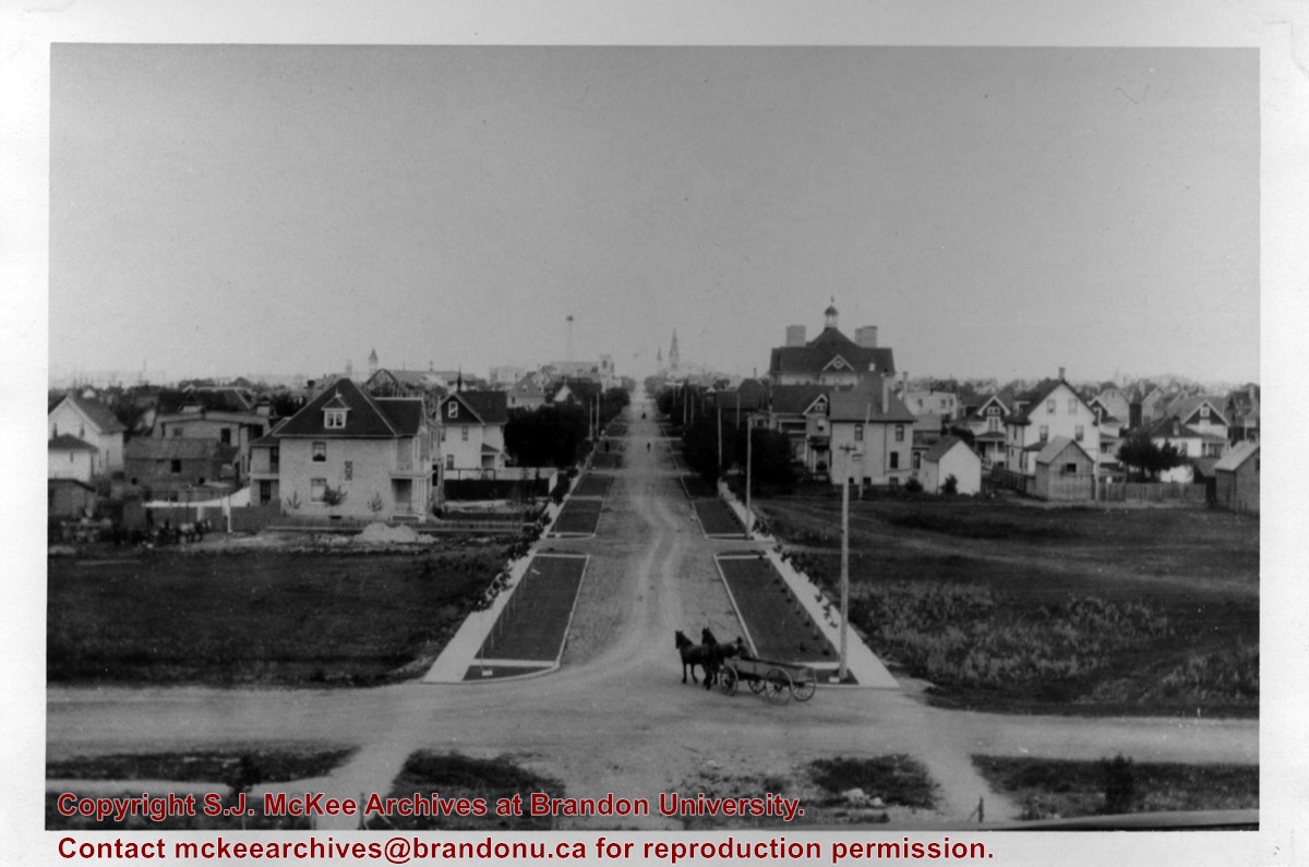
The photograph was taken for the Centennial of Brandon College/University.
Scope and Content
Aerial photograph taken looking southwest from approximately the northeast corner of Princess Avenue and 17th Street. The entire campus, as well as a number of residential streets are visible.
Notes
Negative is located with the photograph
Subject Access
campus buildings
aerial photographs
aerial photography
aerial views
cityscapes
Storage Range
Oversized drawer 4
Images
Show Less

Park School postcard

http://archives.brandonu.ca/en/permalink/descriptions13745
Part Of
Fred McGuinness collection
Description Level
Item
GMD
graphic
Date Range
1910
Accession Number
20-2009
Part Of
Fred McGuinness collection
Creator
Published for Christie's Book Store, Brandon
Description Level
Item
Series Number
McG 9
Item Number
20-2009.56
Accession Number
20-2009
GMD
graphic
Date Range
1910
Physical Description
5.5" x 3.5" (colour)
Material Details
postcard
Physical Condition
Postcard edges are worn
Custodial History
Donated to Fred McGuinness by Mrs. Marian Gray of Brandon, September 13, 1978.
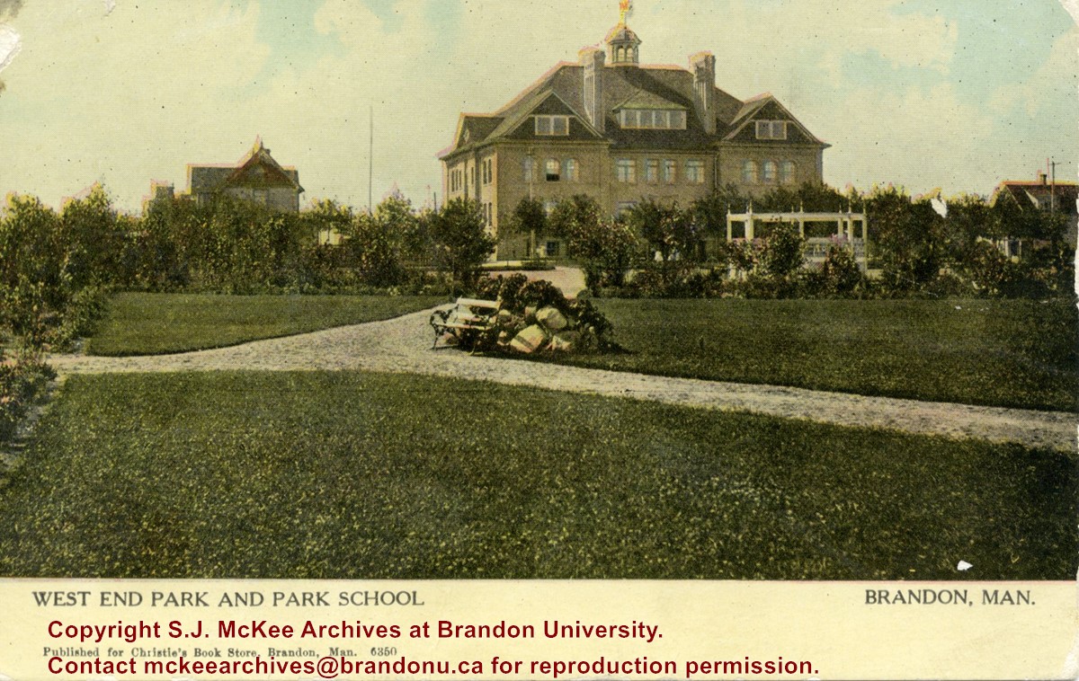
Scope and Content
Postcard shows the West End Park (also known as Stanley Park) and Park School. The school was situated on the southwest corner of Lorne Avenue. A couple of residences surround the school. Walking paths, a park bench, and a gazebo/grandstand can be seen in the park.
Notes
Front of postcard reads: Published for Christie's Book Store, Brandon, Man., 6350. Back of postcard reads: Canadian Souvenir Post Card, Warwick Brothers & Rutter, Limited, Printers, Toronto. The postcard is addressed to Miss Isabella Heastwell of Broderick, Saskatchewan, and is dated July 14, 1910.
Name Access
Park School
West End Park
Lorne Avenue
Stanley Park
Subject Access
postcards
schools
parks
Storage Location
RG 5 photograph storage drawer 2 (hanging photos)
Images
Show Less

International Peace Garden grand opening 1932

http://archives.brandonu.ca/en/permalink/descriptions13774
Part Of
Fred McGuinness collection
Description Level
Item
GMD
graphic
Date Range
1932
Accession Number
20-2009
Part Of
Fred McGuinness collection
Description Level
Item
Series Number
McG 9
Item Number
20-2009.85
Accession Number
20-2009
GMD
graphic
Date Range
1932
Physical Description
5.75" x 3.5" (b/w)
History / Biographical
The International Peace Garden is situated on the international border between Manitoba and North Dakota, adjacent to the Canadian Border Services Boissevain port of entry and the U.S. Customs and Border Protection Agency's Dunseith port of entry. The dedication for the International Peace Garden was held on July 14, 1932. It was estimated that 50,000 people were in attendance on opening day. The park is 9.5-square kilometers or 3.54-square miles.
Custodial History
Pictures were sent to Fred McGuinness in 1970 from E.M. Bergson of Brandon.
Scope and Content
Photograph shows large crowds surrounding a stone cairn draped in American and Union Jack flags. According to the International Peace Garden website, the pictured cairn was built from stones gathered from Manitoba and North Dakota. The crowds gathered for the 1932 dedication of the International Peace Garden.
Notes
The back of the photograph is stamped: Enameloid Velox Print by the Jul 27 1932, Chicago Postal Photo Supplies, Regina, Sask.
Name Access
International Peace Garden
North Dakota
Subject Access
gardens
parks
monuments
Storage Location
RG 5 photograph storage drawer 2 (hanging photos)
Images
Show Less

International Peace Garden grand opening 1932

http://archives.brandonu.ca/en/permalink/descriptions13775
Part Of
Fred McGuinness collection
Description Level
Item
GMD
graphic
Date Range
1932
Accession Number
20-2009
Part Of
Fred McGuinness collection
Description Level
Item
Series Number
McG 9
Item Number
20-2009.86
Accession Number
20-2009
GMD
graphic
Date Range
1932
Physical Description
5.75" x 3.5" (b/w)
History / Biographical
The International Peace Garden is situated on the international border between Manitoba and North Dakota, adjacent to the Canadian Border Services Boissevain port of entry and the U.S. Customs and Border Protection Agency's Dunseith port of entry. The dedication for the International Peace Garden was held on July 14, 1932. It was estimated that 50,000 people were in attendance on opening day. The park is 9.5-square kilometers or 3.54-square miles.
Custodial History
Pictures were sent to Fred McGuinness in 1970 from E.M. Bergson of Brandon.
Scope and Content
Photograph shows large crowds surrounding a stone cairn draped in American and Union Jack flags. According to the International Peace Garden website, the pictured cairn was built from stones gathered from Manitoba and North Dakota. The crowds gathered for the 1932 dedication of the International Peace Garden.
Notes
The back of the photograph is stamped: Enameloid Velox Print by the Jul 27 1932, Chicago Postal Photo Supplies, Regina, Sask.
Name Access
International Peace Garden
North Dakota
Subject Access
gardens
parks
monuments
Storage Location
RG 5 photograph storage drawer 2 (hanging photos)
Images
Show Less

International Peace Garden grand opening 1932

http://archives.brandonu.ca/en/permalink/descriptions13776
Part Of
Fred McGuinness collection
Description Level
Item
GMD
graphic
Date Range
1932
Accession Number
20-2009
Part Of
Fred McGuinness collection
Description Level
Item
Series Number
McG 9
Item Number
20-2009.87
Accession Number
20-2009
GMD
graphic
Date Range
1932
Physical Description
5.75" x 3.5" (b/w)
History / Biographical
The International Peace Garden is situated on the international border between Manitoba and North Dakota, adjacent to the Canadian Border Services Boissevain port of entry and the U.S. Customs and Border Protection Agency's Dunseith port of entry. The dedication for the International Peace Garden was held on July 14, 1932. It was estimated that 50,000 people were in attendance on opening day. The park is 9.5-square kilometers or 3.54-square miles.
Custodial History
Pictures were sent to Fred McGuinness in 1970 from E.M. Bergson of Brandon.
Scope and Content
Photograph shows the crowded parking lot at the International Peace Garden's 1932 dedication ceremony. People mill amongst the automobiles and tents can be seen in the background.
Notes
The back of the photograph is stamped: Enameloid Velox Print by the Jul 27 1932, Chicago Postal Photo Supplies, Regina, Sask.
Name Access
International Peace Garden
North Dakota
Subject Access
gardens
parks
Transportation
automobiles
Storage Location
RG 5 photograph storage drawer 2 (hanging photos)
Images
Show Less
Part Of
Fred McGuinness collection
Description Level
Item
GMD
graphic
Date Range
1980s
Accession Number
20-2009
Part Of
Fred McGuinness collection
Description Level
Item
Series Number
McG 9
Item Number
20-2009.109
Accession Number
20-2009
GMD
graphic
Date Range
1980s
Physical Description
4.5" x 6" (b/w)
Material Details
reproduction
History / Biographical
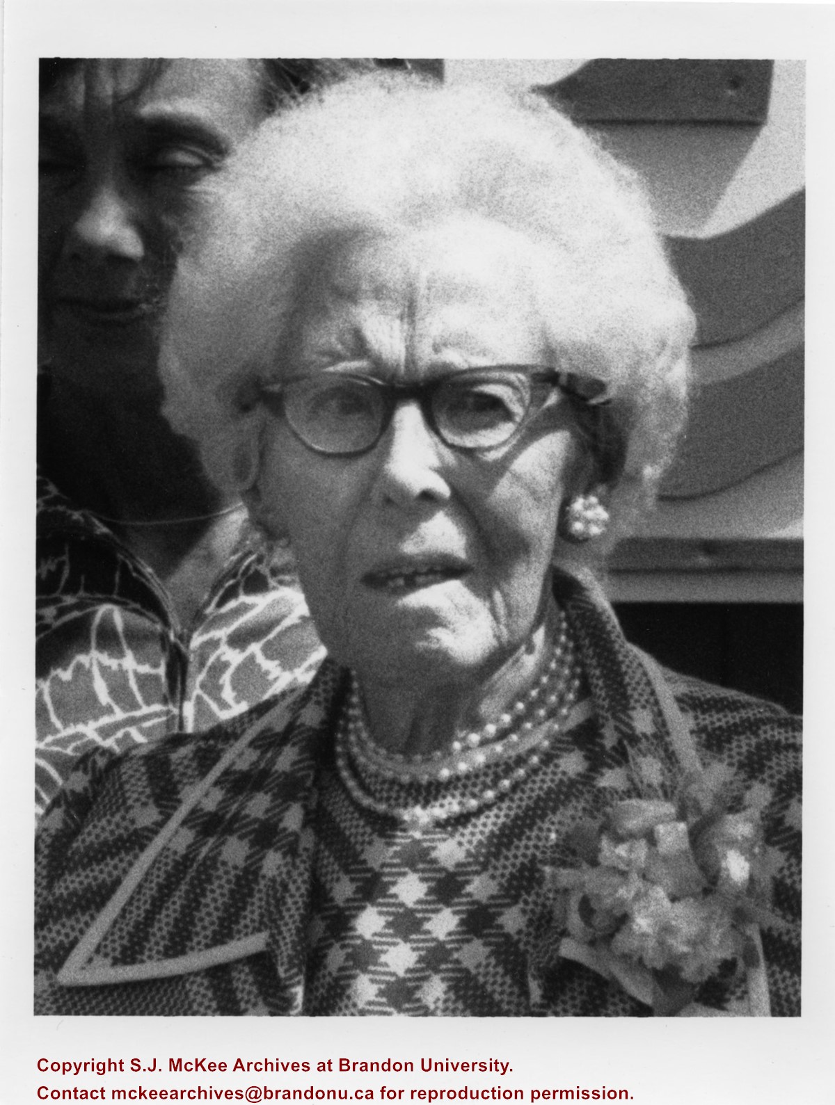
Eleanor Kidd Park (est. 1977) is situated on 18th Street North, on the south side of the Assiniboine River, and east of the Thompson twinned bridge. The park was the former site of an animal shelter overseen by Eleanor Kidd. Adjacent to the park are the Eleanor Kidd Gardens, which contains performance and fountain plazas. The sites have been subjected to heavy flooding from 2011 to 2015. Eleanor Maud Kidd (nee Death) (b.05 Aug 1881, d. 11 July 1978) was born in London, England. She trained as a nurse/midwife at the Liverpool Children's Hospital and worked as a private nurse for affluent families in Italy. She immigrated to Canada in 1913 and lived in Portage la Prairie where she worked as a public health nurse. She ultimately settled in Brandon where she married barber William Wesley Kidd (1873-1951) on November 24, 1921. Mrs. Kidd is credited with incorporating the Brandon SPCA/Humane Society in 1947. She died in Brandon, Manitoba, and is interred in the Brandon Municipal Cemetery. (sources: Brandon Sun 12 July 1978; Brandon Sun 13 July 1978; Manitoba Vital Statistics)
Custodial History
Photograph courtesy of Dirk Aberson
Scope and Content
Photograph is a close-up of Eleanor Kidd posing in front of the Elanor Kidd Park sign.
Notes
Writing on the back of the photograph reads: #136
Name Access
Eleanor Kidd
Brandon Humane Society
Subject Access
parks
Storage Location
RG 5 photograph storage drawer 2 (hanging photos)
Arrangement
Photograph originally in McG 20-2009 #1 File 15
Images
Show Less

George Porterfield in buggy

http://archives.brandonu.ca/en/permalink/descriptions14007
Part Of
Fred McGuinness collection
Description Level
Item
GMD
graphic
Date Range
[19--]
Accession Number
1-2015
Part Of
Fred McGuinness collection
Description Level
Item
Series Number
McG 9
Item Number
1-2015.77
Accession Number
1-2015
GMD
graphic
Date Range
[19--]
Physical Description
5" x 3.5" (b/w)
Material Details
reproduction
Custodial History
Photograph given to Fred McGuinness by Helen Turner
Scope and Content
Photograph shows a man - George Porterfield - dressed in a three-piece and hat sitting at the reins of a horse drawn buggy. The buggy appears to be parked on Lorne Avenue beside the bandstand at Stanely Park.
Notes
Note attached to the back of the photograph reads: This George Porterfield, who lived on a farm 4.9.19. Delivered eggs, cream & milk in Brandon by this method in the early 1920. Maybe he was out courting Mary, he looks pretty dressed up.
Name Access
George Porterfield
Stanley Park
Subject Access
Transportation
buggies
street scenes
parks
residential streets
Storage Location
RG 5 photograph storage drawer 2 (hanging photos)
Arrangement
McG 1.2 file 20
Images
Show Less

Fred McGuinness in convertible

http://archives.brandonu.ca/en/permalink/descriptions14176
Part Of
Fred McGuinness collection
Description Level
Item
GMD
graphic
Date Range
[1955-1965]
Accession Number
1-2015
Part Of
Fred McGuinness collection
Description Level
Item
Series Number
McG 9
Item Number
1-2015.245
Accession Number
1-2015
GMD
graphic
Date Range
[1955-1965]
Physical Description
7" x 5" (colour)
Scope and Content
Photograph shows Fred McGuinness in a white convertible with red interior overlooking the city of Medicine Hat.
Name Access
Frederick George McGuinness
Fred McGuinness
Medicine Hat
Subject Access
automobiles
cars
cityscapes
Storage Location
RG 5 photograph storage drawer 2 (hanging photos)
Arrangement
BR #3 30-personal
Images
Show Less

Downtown of Brandon - 10th Street looking north

http://archives.brandonu.ca/en/permalink/descriptions11701
Part Of
CKX fonds
Description Level
Item
GMD
graphic
Date Range
after 1954
Accession Number
11-2010
Part Of
CKX fonds
Creator
CKX
Description Level
Item
Item Number
11-2010.B139a
Accession Number
11-2010
GMD
graphic
Date Range
after 1954
Physical Description
2.25" x 2.25" (b/w)
Material Details
Negative
Custodial History
See fonds level of the CKX records for custodial history.
Scope and Content
Image of 10th Street looking north from Princess Avenue.
Name Access
CKX Television
Brandon, Manitoba
Subject Access
cityscapes
Storage Location
CKX fonds - 2010 accessions
Images
Show Less

23 records – page 1 of 2.