Photographs have been glued to a backing board that has warped over time
History / Biographical
John Dickson (b. 17 Mar 1854, Scotland; d.15 April 1926, Brandon) was considered one of Brandon’s pioneer dentists. Dickson immigrated to Canada in 1857, where he lived in Hamilton, Ontario, for a number of years. Dickson then came to Manitoba and operated a grocery in Chater before he studied dentistry, graduating from the University of Minnesota in 1886. Dickson settled in Brandon where he married Anna Louise Harrison on 28 December 1891.
The couple had four children: Mrs. Irving Cross [Mary Louise, b.20 Dec 1892, Brandon; d. 22 Oct 1981, Saratoga, NY]; Dr. John Harrison Dickson [b. 26 Aug 1894, Brandon; d. 17 June 1956, Killarney]; Dr. Stanley Rodgers Dickson [b. 18 Feb 1896, Brandon; d. 25 July 1963, Brandon]; and Mrs. Emile Baldeschweiler [Isobel Marion Coates, b. 13 Nov 1900, Brandon; d.?] of New York.
Sources: “Pioneer Dentist of Brandon in Dr. John Dickson,” Brandon Daily Sun 16 Apr 1926 and Manitoba Vital Statistics database.
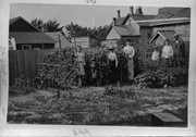
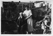
Scope and Content
Photograph is a family in a garden plot in a residential area. Four children, two women, and a man are standing amongst sweet peas. Out buildings of other properties can be seen. Possibly standing from left to right are members of the Dickson family: Mary, Isobel, John Harrison, Annie Louise (wife), Stanley Rodgers, Mrs. Harrison (mother-in-law), and John (husband).
Notes
Writing on the front of the photograph matting reads: 289. Page appears to be from a photo album.
Photographs have been glued to a backing board that has warped over time
History / Biographical
John Dickson (b. 17 Mar 1854, Scotland; d.15 April 1926, Brandon) was considered one of Brandon’s pioneer dentists. Dickson immigrated to Canada in 1857, where he lived in Hamilton, Ontario, for a number of years. Dickson then came to Manitoba and operated a grocery in Chater before he studied dentistry, graduating from the University of Minnesota in 1886. Dickson settled in Brandon where he married Anna Louise Harrison on 28 December 1891. (Source: “Pioneer Dentist of Brandon in Dr. John Dickson,” Brandon Daily Sun 16 Apr 1926)
The couple had four children: Mrs. Irving Cross [Mary Louise, b.20 Dec 1892, Brandon; d. 22 Oct 1981, Saratoga, NY]; Dr. John Harrison Dickson [b. 26 Aug 1894, Brandon; d. 17 June 1956, Killarney]; Dr. Stanley Rodgers Dickson [b. 18 Feb 1896, Brandon; d. 25 July 1963, Brandon]; and Mrs. Emile Baldeschweiler [Isobel Marion Coates, b. 13 Nov 1900, Brandon; d.?] of New York. (Source: Manitoba Vital Statistics database)
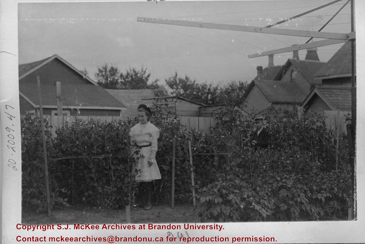
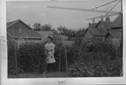
Scope and Content
Photograph is of a girl and a boy standing amongst sweet peas in a backyard garden. A clothes line is visible in the foreground. The children, Mary and Stanley, are possibly those of Brandon dentist John Dickson.
Notes
Writing on the front of the photograph matting reads: 291. Page appears to be from a photo album.
The International Peace Garden is situated on the international border between Manitoba and North Dakota, adjacent to the Canadian Border Services Boissevain port of entry and the U.S. Customs and Border Protection Agency's Dunseith port of entry. The dedication for the International Peace Garden was held on July 14, 1932. It was estimated that 50,000 people were in attendance on opening day. The park is 9.5-square kilometers or 3.54-square miles.
Custodial History
Pictures were sent to Fred McGuinness in 1970 from E.M. Bergson of Brandon.
Scope and Content
Photograph shows large crowds surrounding a stone cairn draped in American and Union Jack flags. According to the International Peace Garden website, the pictured cairn was built from stones gathered from Manitoba and North Dakota. The crowds gathered for the 1932 dedication of the International Peace Garden.
Notes
The back of the photograph is stamped: Enameloid Velox Print by the Jul 27 1932, Chicago Postal Photo Supplies, Regina, Sask.
The International Peace Garden is situated on the international border between Manitoba and North Dakota, adjacent to the Canadian Border Services Boissevain port of entry and the U.S. Customs and Border Protection Agency's Dunseith port of entry. The dedication for the International Peace Garden was held on July 14, 1932. It was estimated that 50,000 people were in attendance on opening day. The park is 9.5-square kilometers or 3.54-square miles.
Custodial History
Pictures were sent to Fred McGuinness in 1970 from E.M. Bergson of Brandon.
Scope and Content
Photograph shows the crowded parking lot at the International Peace Garden's 1932 dedication ceremony. People mill amongst the automobiles and tents can be seen in the background.
Notes
The back of the photograph is stamped: Enameloid Velox Print by the Jul 27 1932, Chicago Postal Photo Supplies, Regina, Sask.
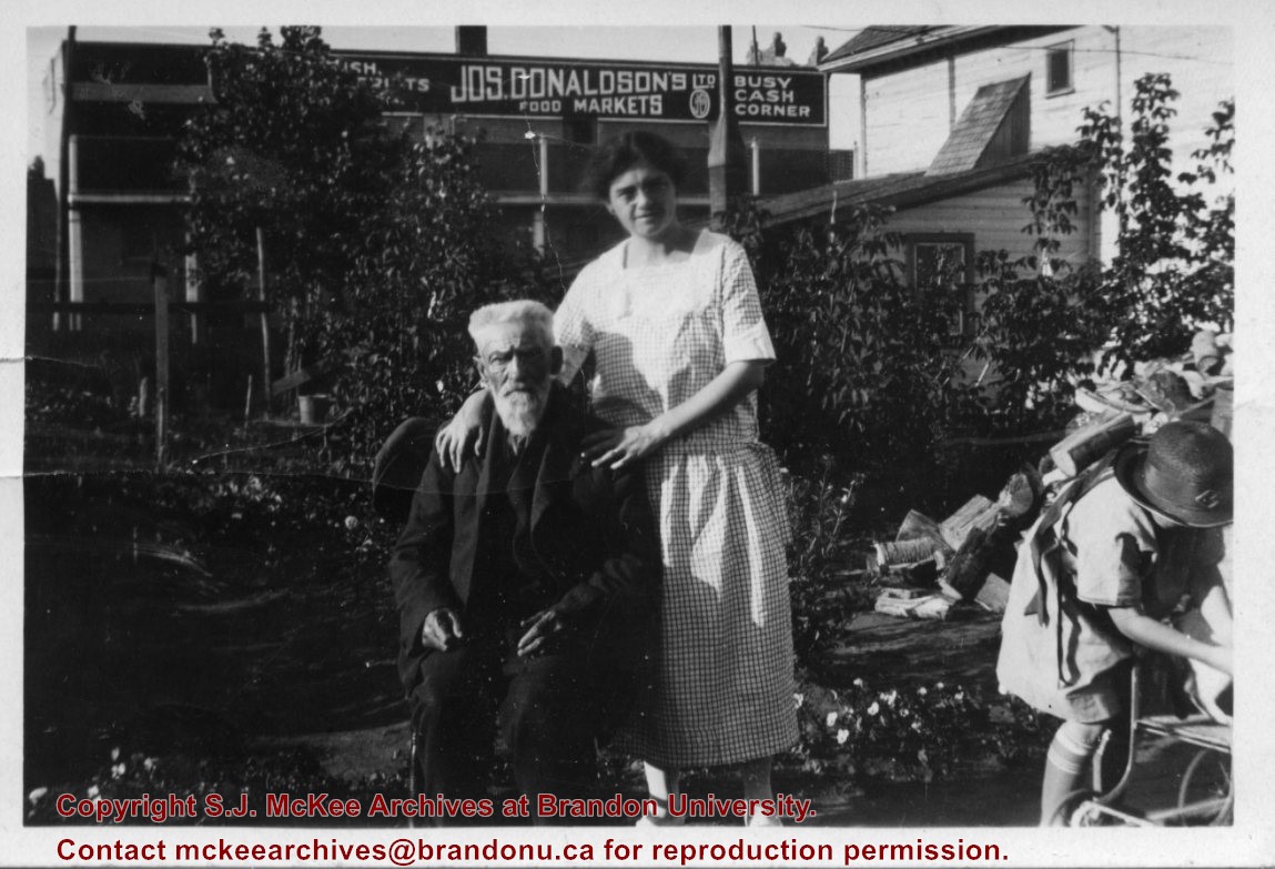
Joseph Donaldson's Ltd. Food Market appears in the Henderson's Brandon City Directory from 1906 to 1929. Donaldson's main meat/butcher shop was located at 813 Rosser Avenue. A second branch was opened by 1914 at 228 Rosser Avenue but relocated to 654 Tenth Street by 1917. The branch relocated by 1921 to 662 Tenth Street where it remained until ca.1929. This address was referred to as the "Busy Corner" in the Henderson's Directory. In 1931, butcher Ted Hill appears to have taken over the Donaldson's establishments.
Scope and Content
Photograph shows George Pope sitting in a backyard. Standing next to him is Isabella Louise McGuinness (Pope). A young girl, perhaps Ruth McGuinness, is standing over a stroller. A wood pile and garden plants can be seen in the backyard. An advertisement for Joseph Donaldson's Ltd Food Markets can be seen on a business beside the residence.
Notes
Writing on the back of the photograph reads: This is mum her uncle George Pope who came to Brandon in 1880 (I think) in the back yard of 708-10th Street. It looked like Ruth in the lower right corner. I was interested in the Donaldson advertising.
According to the Canadian Old-time Radio Alliance website, the Happy Gang radio show was established by Bert Pearl for the CBC in 1937. The show remained on the air until 1959. Colgate Palmolive was the radio show's first sponsor. Other sponsors included Carnation Milk, Mills' Flower, and Red Rose.
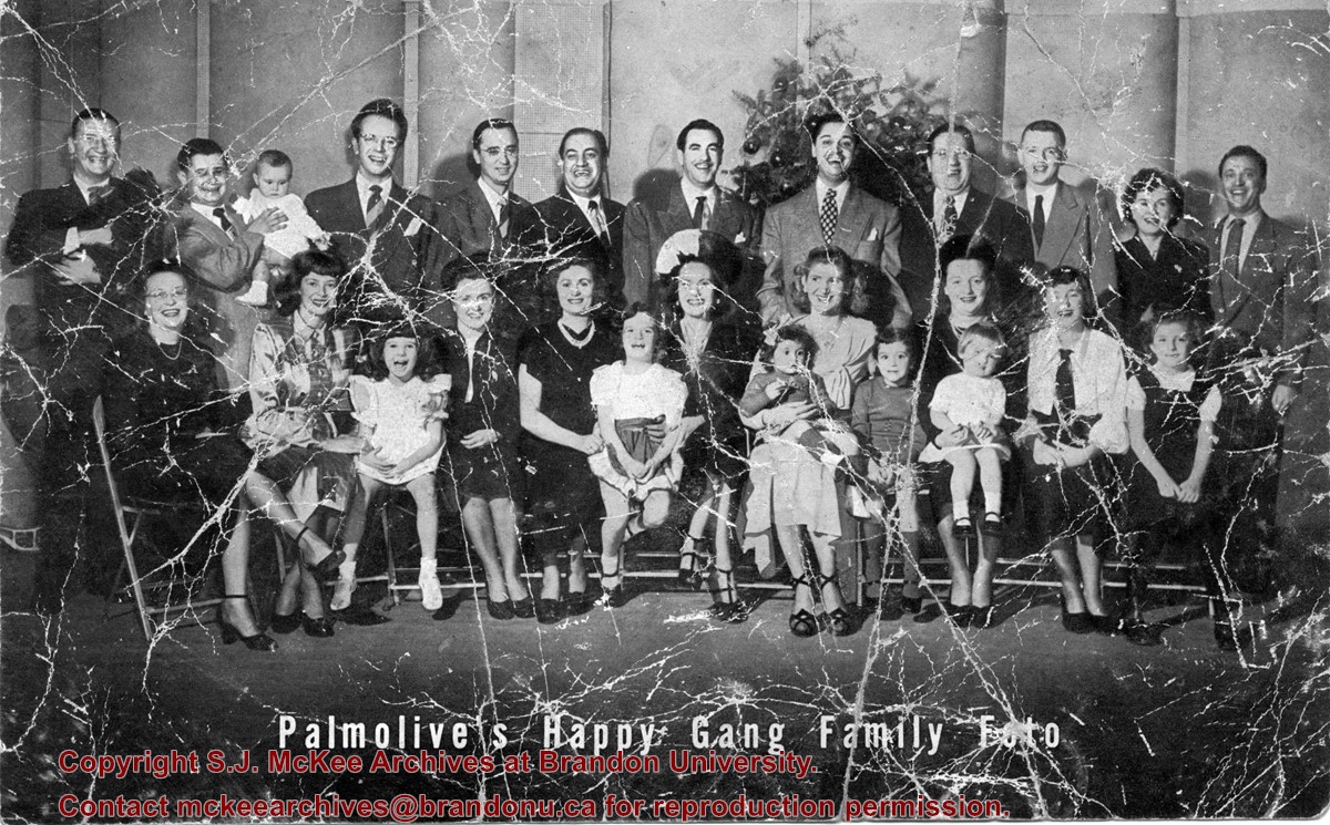
Custodial History
Photograph sent to Fred McGuinness from Lillie S. Wilkins of Killarney, MB
Scope and Content
Photograph shows a group portrait of the "The Happy Gang" family. The promotional photograph was produced for the 143rd anniversary of the Colgate-Palmolive company.
Notes
Members of the Happy Gang are identified on the back of the photograph along with "a message" from Bert Pearl, the M.C. for the Happy Gang. Date of photograph determined from Colgate-Palmolive company history.
The Medicine Hat Exhibition and Stampede Parade Day was held on Thursday, July 19, 1962, at 9:30 a.m. The local newspaper reported that approximately 24,000 people were in attendance to see parade marshall Rod Ashburner leading 175 entries consisting of 90 floats, 75 horses, and 10 bands. There were 19 parade categories eligible for $12,000 in prize money and included: junior and senior cowboys and cowgirls; fancy and Shetland ponies; sulky class open; comic, commercial, industrial and organizational floats; decorated cars; special ranch class; 4-H Clubs; and a non-competitive class.
The parade route started at Second St. and Allowance Ave., from Second St. to Ash Ave., north on Ash to First St. SE., from First St. S.E. to Fourth Ave., south to Second St. to South Railway St., south on South Railway St. to Third St., with a finish at McLeod Trail. A route map was published in the Medicine Hat News the day before the parade.
Aerial photographs of the parade were taken by Medicine Hat News photographer Howard Heid (1930-2005) from the private helicopter of John Bourn. Bourn was a pilot from Woodville, Wisconsin, who chartered his four-seater helicopter for sight-seers at exhibitions and stampedes across the county.
(Sources: Pat Currie, "Let 'Er Go!," Medicine Hat News, 19 July 1962,1; Harald Gunderson, "'Eye in the Sky' Best Parade View," Medicine Hat News, 19 July 1962,1; "Parade Starts at 9:30 Sharp," 18 July 1962)
Scope and Content
Photograph shows an aerial view of the Medicine Hat Exhibition and Stampede Parade route, with a focus on Second Street SE. A residential area showing homes with extensive backyard gardens can be seen. The South Saskatchewan River can be see on the right of the photograph.
Notes
This photograph shows the neighbourhood before rezoning and commercial development.
The Medicine Hat Exhibition and Stampede Parade Day was held on Thursday, July 19, 1962, at 9:30 a.m. The local newspaper reported that approximately 24,000 people were in attendance to see parade marshall Rod Ashburner leading 175 entries consisting of 90 floats, 75 horses, and 10 bands. There were 19 parade categories eligible for $12,000 in prize money and included: junior and senior cowboys and cowgirls; fancy and Shetland ponies; sulky class open; comic, commercial, industrial and organizational floats; decorated cars; special ranch class; 4-H Clubs; and a non-competitive class.
The parade route started at Second St. and Allowance Ave., from Second St. to Ash Ave., north on Ash to First St. SE., from First St. S.E. to Fourth Ave., south to Second St. to South Railway St., south on South Railway St. to Third St., with a finish at McLeod Trail. A route map was published in the Medicine Hat News the day before the parade.
Aerial photographs of the parade were taken by Medicine Hat News photographer Howard Heid (1930-2005) from the private helicopter of John Bourn. Bourn was a pilot from Woodville, Wisconsin, who chartered his four-seater helicopter for sight-seers at exhibitions and stampedes across the county.
(Sources: Pat Currie, "Let 'Er Go!," Medicine Hat News, 19 July 1962,1; Harald Gunderson, "'Eye in the Sky' Best Parade View," Medicine Hat News, 19 July 1962,1; "Parade Starts at 9:30 Sharp," 18 July 1962)
Scope and Content
Photograph shows an aerial view of the Medicine Hat Exhibition and Stampede Parade route with a focus on the First Street SE and Ash Street. A residential area showing homes with extensive backyard gardens can be seen.
Notes
This photograph shows the neighbourhood before rezoning and commercial development.
The Medicine Hat Exhibition and Stampede Parade Day was held on Thursday, July 19, 1962, at 9:30 a.m. The local newspaper reported that approximately 24,000 people were in attendance to see parade marshall Rod Ashburner leading 175 entries consisting of 90 floats, 75 horses, and 10 bands. There were 19 parade categories eligible for $12,000 in prize money and included: junior and senior cowboys and cowgirls; fancy and Shetland ponies; sulky class open; comic, commercial, industrial and organizational floats; decorated cars; special ranch class; 4-H Clubs; and a non-competitive class.
The parade route started at Second St. and Allowance Ave., from Second St. to Ash Ave., north on Ash to First St. SE., from First St. S.E. to Fourth Ave., south to Second St. to South Railway St., south on South Railway St. to Third St., with a finish at McLeod Trail. A route map was published in the Medicine Hat News the day before the parade.
Aerial photographs of the parade were taken by Medicine Hat News photographer Howard Heid (1930-2005) from the private helicopter of John Bourn. Bourn was a pilot from Woodville, Wisconsin, who chartered his four-seater helicopter for sight-seers at exhibitions and stampedes across the county.
(Sources: Pat Currie, "Let 'Er Go!," Medicine Hat News, 19 July 1962,1; Harald Gunderson, "'Eye in the Sky' Best Parade View," Medicine Hat News, 19 July 1962,1; "Parade Starts at 9:30 Sharp," 18 July 1962)
Scope and Content
Photograph shows an aerial view of the Medicine Hat Exhibition and Stampede Parade route with a focus on the First Street SE and and the South Railway Street merge. A number of gas stations and garages are visible along this route and include Texaco, Shell, Ford, and B/A. The Fraternal Order of Eagles lodge is also visible.
Notes
This photograph shows the neighbourhood before rezoning and commercial development.
The Medicine Hat Exhibition and Stampede Parade Day was held on Thursday, July 19, 1962, at 9:30 a.m. The local newspaper reported that approximately 24,000 people were in attendance to see parade marshall Rod Ashburner leading 175 entries consisting of 90 floats, 75 horses, and 10 bands. There were 19 parade categories eligible for $12,000 in prize money and included: junior and senior cowboys and cowgirls; fancy and Shetland ponies; sulky class open; comic, commercial, industrial and organizational floats; decorated cars; special ranch class; 4-H Clubs; and a non-competitive class.
The parade route started at Second St. and Allowance Ave., from Second St. to Ash Ave., north on Ash to First St. SE., from First St. S.E. to Fourth Ave., south to Second St. to South Railway St., south on South Railway St. to Third St., with a finish at McLeod Trail. A route map was published in the Medicine Hat News the day before the parade.
Aerial photographs of the parade were taken by Medicine Hat News photographer Howard Heid (1930-2005) from the private helicopter of John Bourn. Bourn was a pilot from Woodville, Wisconsin, who chartered his four-seater helicopter for sight-seers at exhibitions and stampedes across the county.
(Sources: Pat Currie, "Let 'Er Go!," Medicine Hat News, 19 July 1962,1; Harald Gunderson, "'Eye in the Sky' Best Parade View," Medicine Hat News, 19 July 1962,1; "Parade Starts at 9:30 Sharp," 18 July 1962)
Scope and Content
Photograph shows an aerial view of the Medicine Hat Exhibition and Stampede Parade route with a focus on the First Street SE and Ash Street. A residential area showing homes with extensive backyard gardens can be seen.
Notes
This photograph shows the neighbourhood before rezoning and commercial development.
The Medicine Hat Exhibition and Stampede Parade Day was held on Thursday, July 19, 1962, at 9:30 a.m. The local newspaper reported that approximately 24,000 people were in attendance to see parade marshall Rod Ashburner leading 175 entries consisting of 90 floats, 75 horses, and 10 bands. There were 19 parade categories eligible for $12,000 in prize money and included: junior and senior cowboys and cowgirls; fancy and Shetland ponies; sulky class open; comic, commercial, industrial and organizational floats; decorated cars; special ranch class; 4-H Clubs; and a non-competitive class.
The parade route started at Second St. and Allowance Ave., from Second St. to Ash Ave., north on Ash to First St. SE., from First St. S.E. to Fourth Ave., south to Second St. to South Railway St., south on South Railway St. to Third St., with a finish at McLeod Trail. A route map was published in the Medicine Hat News the day before the parade.
Aerial photographs of the parade were taken by Medicine Hat News photographer Howard Heid (1930-2005) from the private helicopter of John Bourn. Bourn was a pilot from Woodville, Wisconsin, who chartered his four-seater helicopter for sight-seers at exhibitions and stampedes across the county.
(Sources: Pat Currie, "Let 'Er Go!," Medicine Hat News, 19 July 1962,1; Harald Gunderson, "'Eye in the Sky' Best Parade View," Medicine Hat News, 19 July 1962,1; "Parade Starts at 9:30 Sharp," 18 July 1962)
Scope and Content
Photograph shows an aerial view of the Medicine Hat Exhibition and Stampede Parade route with a focus west of the railway allowance, showing First Street SE, Second Street SE, and Third Street SE.
Notes
This photograph shows the neighbourhood before rezoning and commercial development.
The Medicine Hat Exhibition and Stampede Parade Day was held on Thursday, July 19, 1962, at 9:30 a.m. The local newspaper reported that approximately 24,000 people were in attendance to see parade marshall Rod Ashburner leading 175 entries consisting of 90 floats, 75 horses, and 10 bands. There were 19 parade categories eligible for $12,000 in prize money and included: junior and senior cowboys and cowgirls; fancy and Shetland ponies; sulky class open; comic, commercial, industrial and organizational floats; decorated cars; special ranch class; 4-H Clubs; and a non-competitive class.
The parade route started at Second St. and Allowance Ave., from Second St. to Ash Ave., north on Ash to First St. SE., from First St. S.E. to Fourth Ave., south to Second St. to South Railway St., south on South Railway St. to Third St., with a finish at McLeod Trail. A route map was published in the Medicine Hat News the day before the parade.
Aerial photographs of the parade were taken by Medicine Hat News photographer Howard Heid (1930-2005) from the private helicopter of John Bourn. Bourn was a pilot from Woodville, Wisconsin, who chartered his four-seater helicopter for sight-seers at exhibitions and stampedes across the county.
(Sources: Pat Currie, "Let 'Er Go!," Medicine Hat News, 19 July 1962,1; Harald Gunderson, "'Eye in the Sky' Best Parade View," Medicine Hat News, 19 July 1962,1; "Parade Starts at 9:30 Sharp," 18 July 1962)
Scope and Content
Photograph shows an aerial view of possibly 8th Street NW and Tweed Avenue NW. A Safeway grocery store, park and residential area are visible. Many of hte homes appear to have gardens.
Notes
This photograph shows the neighbourhood before rezoning and commercial development.
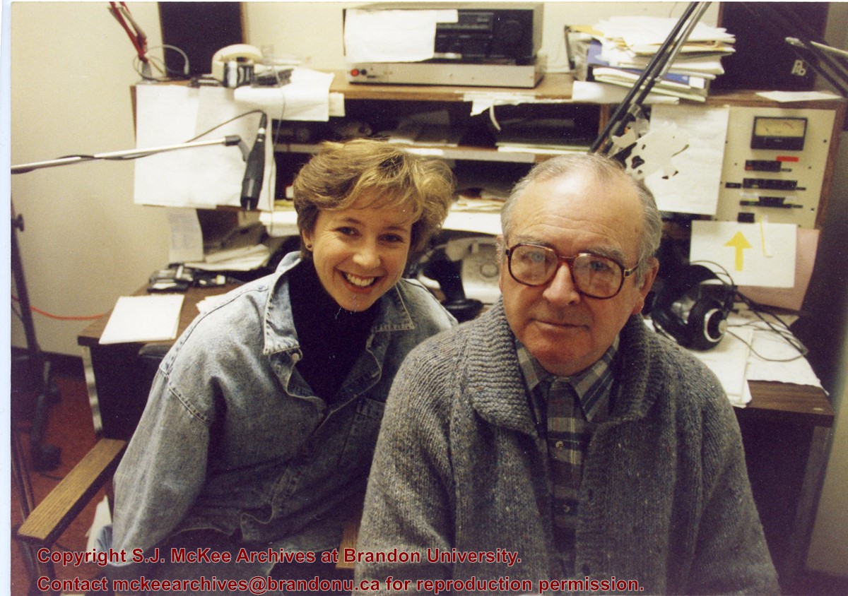
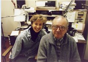
Photograph was sent to Fred McGuinness from Shirley
Scope and Content
Photograph shows Fred McGuinness seated in a recording room with a female colleague. Microphones and recording equipment can be seen on a desk behind the pair.
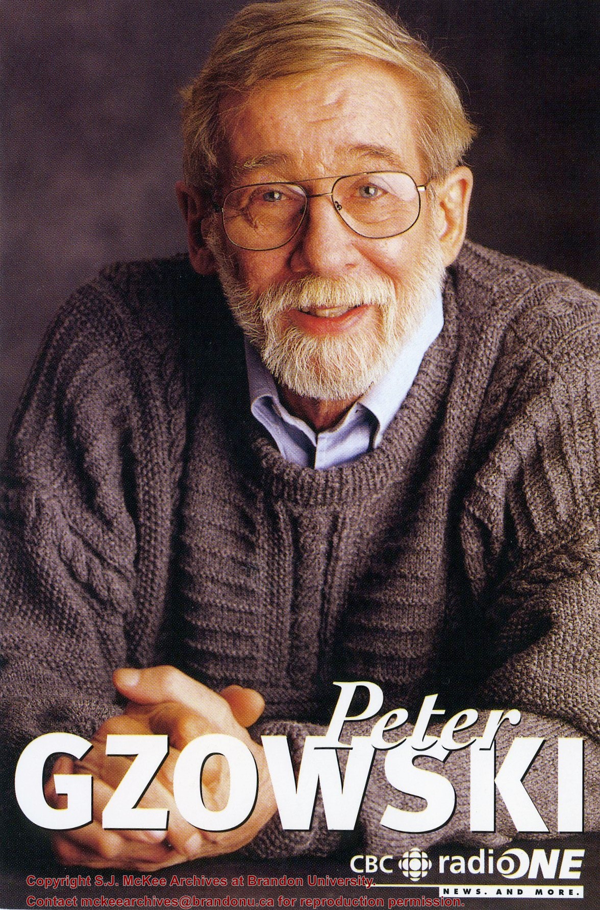
Photograph shows a promotional shot of CBC Radio host Peter Gzowki for CBC Radio One.
Notes
Writing on the back of the postcard reads: Baron! Dear Fred - okay, okay so the photos aren't great...these are your copies anyways! How you are well - Love Shelley (the Countess)
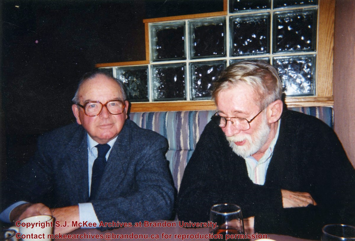
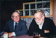
After the cancellation of McGuinness’ CBC Radio broadcast “Neighborly News from the Prairies” that he hosted from 1980 to 1983, McGuinness continued working with the CBC. He was popularly known for his work as the prairie essayist for CBC Radio’s Morningside with Peter Gzowski, a position he held for 17 years.
Scope and Content
Photograph shows Fred McGuinness (left) and Peter Gzowki (right) having coffee in a restaurant.
Notes
Writing on the back of the postcard reads: Baron! Dear Fred - okay, okay so the photos aren't great...these are your copies anyways! How you are well - Love Shelley (the Countess)
Manitoba Pool Elevators was quick to realize the usefulness of the radio medium as a educational and promotional tool. It was also often used to defend the Pool and the co-operative movement in general on programs such as Farm Radio Forum. See fonds level description of RG 4 for complete history/bio of MPE.
Scope and Content
Sub-series MPE B.10 consists of textual radio broadcast transcriptions. The records include transcriptions from 1930 until 1971. Radio broadcasts are on a wide variety of topics, including argicultural science, the grain market and general economy of Canada and the world, government acts and legislation that affected the producer, co-operatives and the co-operative movement, rural life, young people, WWII, Manitoba, and the Manitoba Pool Elevators.
/17-2011_8.jpg?width=1200&404=no-img.jpg&watermark=wmk)
/17-2011_8.jpg?width=180&404=no-img.jpg)
/17-2011_10.jpg?width=1200&404=no-img.jpg&watermark=wmk)
/17-2011_10.jpg?width=180&404=no-img.jpg)
/17-2011_11.jpg?width=1200&404=no-img.jpg&watermark=wmk)
/17-2011_11.jpg?width=180&404=no-img.jpg)


%2f17-2011_8.jpg%3fmaxheight%3d1000%26maxwidth%3d1000%26watermark%3dwmk&description=Brandon+Indian+School+farm)
%2f17-2011_10.jpg%3fmaxheight%3d1000%26maxwidth%3d1000%26watermark%3dwmk&description=Brandon+Indian+School+garden+boys)
%2f17-2011_11.jpg%3fmaxheight%3d1000%26maxwidth%3d1000%26watermark%3dwmk&description=Brandon+Indian+School+garden+boys)