Gerry Beaubier was born in Wainwright, Alberta to Beatty and Babe Beaubier. He completed his high school in Saskatoon, before receiving a BSc in Geography from Brandon University.
Before attending university Gerry served in the army as a special reserve, while working as a night clerk at the Bessbourough Hotel in Saskatoon. His post-graduate career consisted primarily of work for Canada Agriculture, under the PFRA Branch (Prairie Farm Rehabilitation Administration). Later he would work as an Executive Manager, helping develop forage and range management programs for several post secondary schools, including, Assiniboine Community College, as well as schools in Red Deer, Lethbridge, and Saskatoon.
Gerry Beaubier married Joyce Abercrombie, of Saskatoon. Together they had two sons: Neil and Dean. Neil, an Account Advisor for the Royal Bank, was born in Regina, and currently works in Swift Current. Dean was born in Swift Current, received his PhD in Education and currently lives in Forrest working at Elton Collegiate.
The Beaubiers, who were originally from Ireland, emigrated to the Canadian West, making Gerry part of the fourth generation of his family to call the region home. His great-grandfather, along with his grandfather and great uncle were amongst the first one hundred settlers in Brandon. Together they first built the Beaubier House, a boarding house for early settlers and travellers. After it burnt down they began construction on the Beaubier Hotel, which stood at the corner of 8th Street and Princess Avenue in Brandon until August 17th, 2008. His grandfather, David Wilson Beaubier, continued to build and operate hotels throughout the prairies, including the Empire Hotels (of Brandon and Saskatoon) and The Park (Moose Jaw).
David Wilson Beaubier served as a secretary of the Orange Lodge of Manitoba. As an Orange Lodge Colonel, he worked with other Orange Lodge members, to recruit throughout the prairies for the purpose of World War One. For his efforts , David was promoted to Leftenant Colonel, and later Captain of the 99th Manitoba Rangers. David's sons (Gerry’s father, at University of Manitoba, and uncle at McGill), were both working towards undergraduate degrees when war broke out in 1914, and each would leave school to join their father at Camp Hughes.
Custodial History
Gerry Beaubier collected these photos primarily in the years 2000-2011, largely
from family and friends who knew of his interest in the topic. They were donated to the S.J. Mckee Archives in 2011.
Scope and Content
Collection consists of digital photographs of those who trained for battle in World War I at Camp Hughes and in Brandon, Manitoba. It also includes a digital copy of the cover of the Nominal Roll of Officers, Non-Commissioned Officers and Men, who departed from Brandon in 1917.
The photos, taken primarily at Camp Hughes, are of a number of battalions, including the 34th, 100th, 108th, 181st and 214th. The photo, PT in England, is a postcard sent home from Beaty Beaubier. The Massey Harris building seen on the right side of, WW1 B parade0001, was used to house troops throughout the war. The man standing alone at the front of the parade in, 181 Parade, is David Wilson Beaubier.
Notes
Information for the biographical and custodial histories was provided by Gerry Beaubier on September 25, 2013. Description by Dustin Lane (October 2013).
Situated in the R.M. of Whitehead on the Little Saskatchewan River, the 10 Mile Dam was a 14 kilometer transmission line that supplied the city of Brandon with power. The Brandon Electric Light Company built the dam in 1900 and it is considered Manitoba's first hydroelectic power generating station. The dam spanned approximately 80 meters and was constructed from timber and reinforced with clay and stone. The station was decommissioned in 1924.
Scope and Content
Photograph shows 10 Mile Dam, also known as the Brandon Dam or Minnedosa River Hydro Plant.
Notes
Writing on the back of the photograph reads: "10 mile dam". Biographical information obtained from Manitoba Historical Society.
Situated in the R.M. of Whitehead on the Little Saskatchewan River, the 10 Mile Dam was a 14 kilometer transmission line that supplied the city of Brandon with power. The Brandon Electric Light Company built the dam in 1900 and it is considered Manitoba's first hydroelectic power generating station. The dam spanned approximately 80 meters and was constructed from timber and reinforced with clay and stone. The station was decommissioned in 1924.
Alonzo Archibald Rowe (b. 1862, London, ON; d. 22 Oct 1951, Brandon). The Rowes were considered Brandon area pioneers. Alonzo’s father, Alonzo L. Rowe, came to Brandon with his family in 1881, where the family had a furniture and undertaker business on the west side of 10th Street between Rosser and Princess Avenues. In 1885, the family began farming west of Brandon and Alonzo Archibald served as a councilor and then a reeve in the R.M. of Whitehead. He returned to Brandon in 1907 and served with the Brandon Police Department until 1910, when he returned to farming, this time in Arrow River. A.A. Rowe returned to Brandon in 1915 to work as a Provincial Licenses Inspector, a position he held until 1938. (Source: Obituary, Brandon Daily Sun 22 Oct 1951)
Custodial History
Photograph was in possession of Mrs. Ruby Miles, who passed the image on to Fred McGuinness. McGuinness makes reference to Mrs. Miles and this photograph in his Sunbeams column (Source: F.A. Rosser, "Another interesting chat with a daughter of the plains," Brandon Sun 18 Aug 1981).
Scope and Content
Photograph shows four fishermen at 10 Mile Dam, also known as the Brandon Dam or Minnedosa River Hydro Plant. The fishermen in the photo are identified as George H. Rowe and his father A.A. Rowe, Dr. Wilfred Bigelow, and Al Collins.
Notes
Writing on the back of the photograph reads: at Brandon Dam, [right to left] son and father - George H. ROWE, Mr. A.A. ROWE, Dr. BIGELOW, Al COLLINS (dam?, 1906?, George born March 1897); Jerrett's Photo-Services, May 7 1938.
Left hand corner of mat is bent. Mock-up instructions are written in pencil at the bottom right hand corner. Portions of the photograph itself are marked with pen.
History / Biographical
The Queen's Hotel was located on the corner of Rosser Avenue and Tenth Street (Steen & Boyce, 1882. Brandon, Manitoba, Canada and Her Industries. Steen & Boyce Publishers Printers & Binders, 81.). Therefore this photo appears to display Rosser Avenue looking east. P.E. 11/06/09
Scope and Content
Photograph shows early Rosser Avenue under construction between 9th Street and 10th Street in the 1880s. Buildings that line the avenue are wood framed and there are wooden boardwalks in front of a few structures. On the north side of Rosser Avenue signs for Fortier & Bucke Commision Agents and Transit House (Hotel) can be seen. On the south side of Rosser Avenue, the Queen's Hotel and Robinson Brothers and Company groceries and dry goods store are open for business. A family appears to be standing on the stoop at the dry goods store. A boy is lounging in the entryway of the Queen's Hotel. A man is standing on a wooden plank that extends across the dirt road of Rosser Avenue between the dry goods store and the commission agents' shop.
Postcard shows the 100 block of 10th Street facing north. The CPR train station can be seen at the end of 10th Street. The sign for the Rex Cafe is visible on the west side of 10th Street. On the east side of 10th Street, billboards for Campbell & Campbell furniture are visible as well as signs for Pianos and the Orpheum Theatre. Motorists and cyclists share the road. Street car tracks run the length of 10th Street.
Notes
Back of postcard reads: Morning reflection of Brandon's skyline on the Assiniboine River, photo by Sandy Black, printed in Brandno, Manitoba, Canada by Leech Printing Ltd.
Photograph mat is bent. Emulsion problems with image.
Scope and Content
Photograph shows Rosser Avenue in its incipient stages. Canvas tents are mixed amongst wooden structures. The James Smart Hardware store, Winter & O'Neail Groceries & Provisions, and the law office of F.G.A. Henderson in the Molesworth Block can be seen on the north side of Rosser Avenue. A street sign designating 6th Street can be seen below the Winter & O'Neail sign. A horse and buggie is traveling down the dirt track that is Rosser Avenue. Groups of men can be seen congregating outside some of the local businesses.
Notes
Front of photograph reads: Rosser Avenue, Brandon 1882-1883, from east of Six Street. Back of photograph is stamped: I. Bennetto & Co., Photographers, Opposite Post-Office, Winnipeg, Man.
Corners of photograph mat are bent. Picture is cracked.
Scope and Content
Photograph shows an early view of Brandon's 6th Street in the 1880s. The Winter & O'Neail Groceries & Provisions and James Smart Hardware storefronts have been photographed. A street sign designating 6th Street can be seen below the Winter & O'Neail sign. A horse and cart is parked in front of the grocery store. A number of men wearing hats and jackets are standing along the boardwalk while posing for the picture. Lumber/timber saws are displayed in teh windows of the hardware store.
Notes
Front of photograph reads: 6th Street, Brandon, Manitoba, 1881-1882, Entrance [to Winter & O'Neail] corner of Rosser Ave & 6th Street.
Situated in the R.M. of Whitehead on the Little Saskatchewan River, the 10 Mile Dam was a 14 kilometer transmission line that supplied the city of Brandon with power. The Brandon Electric Light Company built the dam in 1900 and it is considered Manitoba's first hydroelectic power generating station. The dam spanned approximately 80 meters and was constructed from timber and reinforced with clay and stone. The station was decommissioned in 1924.
Scope and Content
Photograph shows 10 Mile Dam, also known as the Brandon Dam or Minnedosa River Hydro Plant. The dam's timber construction is quite evident in the picture.
Notes
Writing on the back of the photograph reads: McGuinness (Manitoba Hydro), on Little Saskatchewan.
Photograph shows the 800 block of Rosser Avenue facing west. On the south side of Rosser Avenue the Nation Block, Christie's Bookstore, and Reesor's Clock can be seen. A number of horse and buggies/carriages are travelling along Rosser Avenue.
Kirkham's Bridge was built in 1906, to replace an earlier wooden bridge. The bridge was used until 1981, when it was purchased by the Town of Birtle and moved to a newsite. A former railway pridge was installed in its place.
Scope and Content
Photograph shows Kirkham's Bridge, a steel truss bridge that spanned the Little Saskatchewan River in the Municipality of Riverdale.
Notes
Identification of the bridge provided by Ken Storie (2023). Additional information taken from the Manitoba Historical Society website.
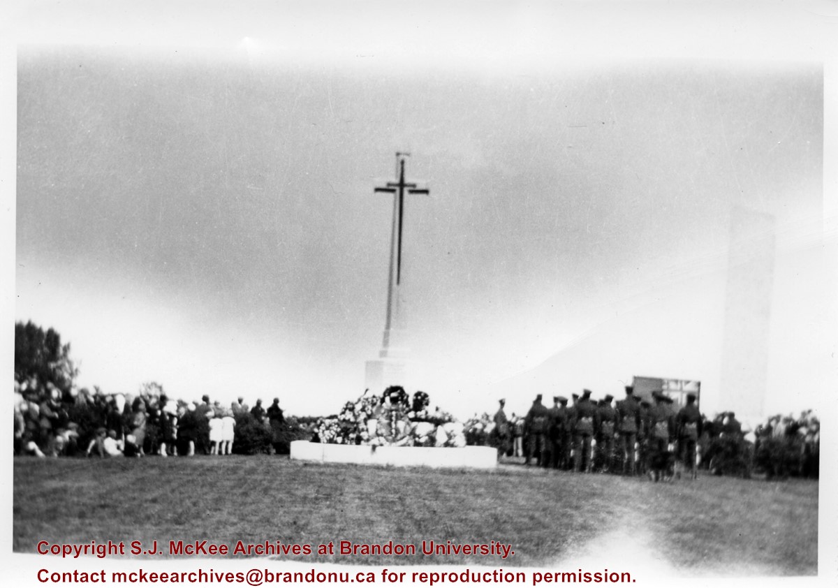
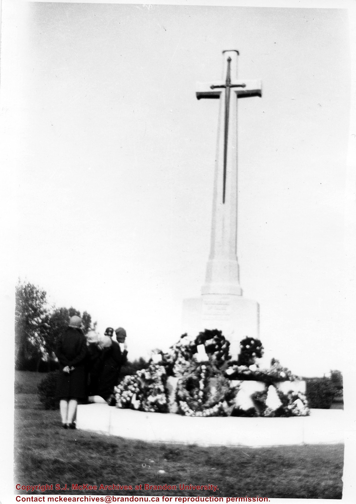
According to Veterans' Affairs Canada, there are 25 Crosses of Sacrifice in North America. The crosses were designed by the Canadian War Graves Commission's (CWGC) architect Sir Reginald Bloomfield, who designed a stone cross affixed with a bronze symbolic sword. The CWGC granted the Brandon Municipal Cemetery permission to privately erect the Cross of Sacrifice in its cemetery in exchange for maintaining the war graves in its cemetery.
The Brandon Great War Veterans Association erected the Cross of Sacrifice in the Brandon Municipal Cemetery in 1924 after a 10-day public fundraising campaign. At the time the Brandon Daily Sun reported that the Veterans Association required $5,000 to pay for the cross and the campaign ultimately raised $7,500. The memorial was initially dedicated to the local citizens who died as a result of the First World War.
Custodial History
Donated to Fred McGuinness by G. Baldock in 1971
Scope and Content
Photograph is of a memorial service at the Cross of Sacrifice in the Brandon Municipal Cemetery. Members of the public are standing to the north of the cross, while soldiers and veterans stand to the south. A number of wreaths have been placed at the base of the monument.
Notes
Writing on the back of the photograph reads: 5 prints. Dedication of the war memorial. around 1926-1927-28. I was scout master under Comissioner Harry Booth. P.E.H.
According to Veterans' Affairs Canada, there are 25 Crosses of Sacrifice in North America. The crosses were designed by the Canadian War Graves Commission's (CWGC) architect Sir Reginald Bloomfield, who designed a stone cross affixed with a bronze symbolic sword. The CWGC granted the Brandon Municipal Cemetery permission to privately erect the Cross of Sacrifice in its cemetery in exchange for maintaining the war graves in its cemetery.
The Brandon Great War Veterans Association erected the Cross of Sacrifice in the Brandon Municipal Cemetery in 1924 after a 10-day public fundraising campaign. At the time the Brandon Daily Sun reported that the Veterans Association required $5,000 to pay for the cross and the campaign ultimately raised $7,500. The memorial was initially dedicated to the local citizens who died as a result of the First World War.
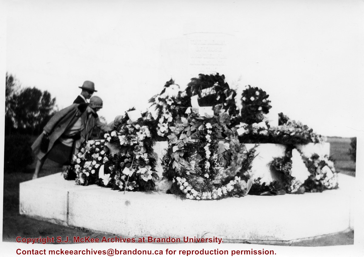
Private Frank Barker (#33281) died on 27 June 1918. A member of the Canadian Army Medical Corps, Pte. Barker was on the Llandovery Castle Hospital Ship when it was torpedoed.
Custodial History
Donated to Fred McGuinness by G. Baldock in 1971
Scope and Content
Photograph is of a close-up of a number of wreaths laid at the base of the Cross of Sacrifice in the Brandon Municipal Cemetery during a memorial service.
Notes
Writing on the back of the photograph reads: Winnifred Barker places wreath in memory of Frank Barker (my uncle) 1st Field Ambulance, many decorations including the "Mons Star," lost on the Hospital Ship Landovery Castle, 1918. - G. Baldock 1971 -
According to Veterans' Affairs Canada, there are 25 Crosses of Sacrifice in North America. The crosses were designed by the Canadian War Graves Commission's (CWGC) architect Sir Reginald Bloomfield, who designed a stone cross affixed with a bronze symbolic sword. The CWGC granted the Brandon Municipal Cemetery permission to privately erect the Cross of Sacrifice in its cemetery in exchange for maintaining the war graves in its cemetery.
The Brandon Great War Veterans Association erected the Cross of Sacrifice in the Brandon Municipal Cemetery in 1924 after a 10-day public fundraising campaign. At the time the Brandon Daily Sun reported that the Veterans Association required $5,000 to pay for the cross and the campaign ultimately raised $7,500. The memorial was initially dedicated to the local citizens who died as a result of the First World War.
Custodial History
Donated to Fred McGuinness by G. Baldock in 1971
Scope and Content
Photograph is of a group of people examining wreaths that have been laid at the base of the Cross of Sacrifice in the Brandon Municipal Cemetery during a memorial service.
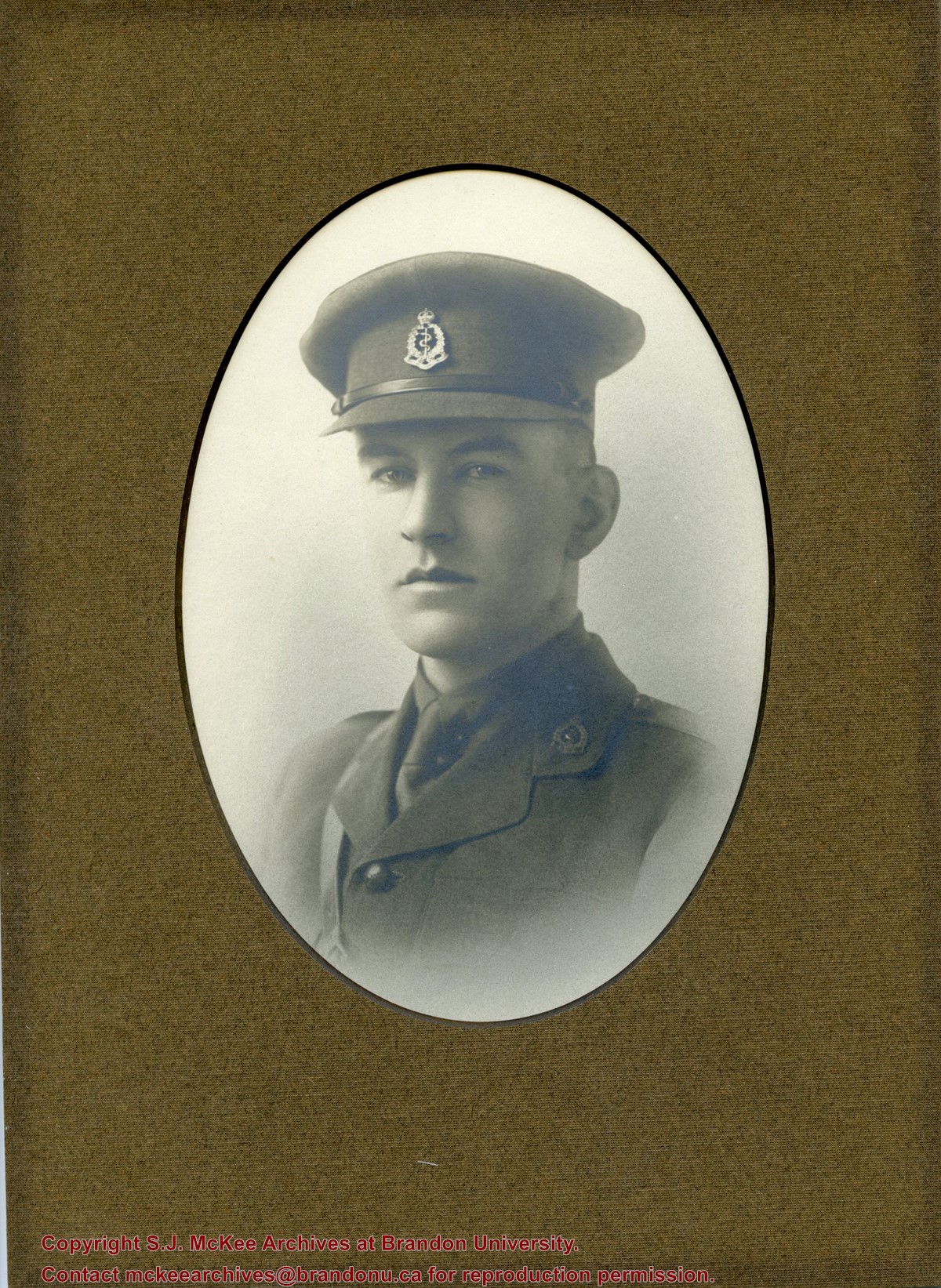
Frederick Gallagher McGUINNESS (b. 1891 – d. 23 May 1968) was born in Ottawa, Ontario. While in Brandon, he was a student (1911) and secretary of Boys’ Work for the YMCA in 1913. He moved to Winnipeg where he graduated from the Manitoba Medical College in 1917. On 3 December 1917, Lieutenant F.G. McGuinness enlisted with the Canadian Army Medical Corps in Winnipeg. He served in France with the Royal Army Medical Corps and was a Medical Officer attached with the Ninth Royal Irish Fusiliers. Lt. McGuiness survived the war and returned to Winnipeg where he married Myrtle Eva White in Winnipeg on 12 September 1922. They would have a son Jim “Jimmy” and a daughter Elizabeth (Shannon). Dr. McGuinness practiced in Obstetrics and Gynecology and taught at the University of Manitoba’s Medical School from 1923 onwards. He was instrumental in helping his nephew, Frederick George McGuinness return to school after he was injured in the Second World War. Dr. McGuinness died in Winnipeg at the Deer Lodge Hospital following a lengthy illness.
Scope and Content
Photograph shows a WWI portrait of Frederick Gallagher McGuinness (Fred McGuinness' uncle) in a Canadian Army Medical Corps (CAMC) officer's uniform.
Photograph shows a crowded and muddy Brandon street. A military parade consisting of a band and mounted cavalry fill the street. A banner extends across the street reading: Brandon Heartily Wecomes Her Returning Heros.
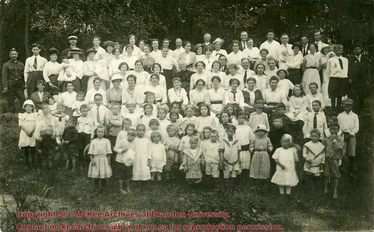
Photograph was given to Fred McGuinness by Linda Bilkoski (nee Lepard) of Lac du Bonnet, MB.
Scope and Content
Photograph shows a large group of men, women and children posing in a park. A man in a WWI Canadian uniform is standing in the back row, left-hand side.
Notes
Writing on the back of the photograph reads: Methodist Mission Sunday School Picnic taken in the Assiboine [sic.] Park. 1st 1915. 1915. Mr. Hugh Connolly Minister, Mr. Fred Denstedt, Teacher. Miss Hornbrook, Bible Class teacher. Mr. John Davies, Choir Leader. Mrs. Foreman in the center in dark dress the oldest member & four babies. Mrs. E. Harden, 33-10th Street N., City.


