Foxing on matting and photograph, primarily along edges of photograph
Custodial History
Mona McKinnon (nee Corkish) gave photograph to Colleen McGuinness who, in turn, gave it to her father, Fred McGuinness in 2007.
Scope and Content
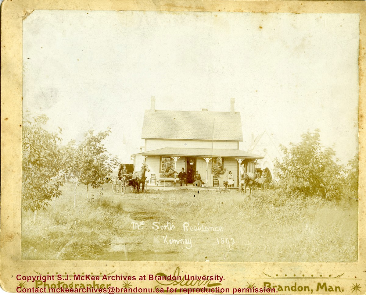
Photograph shows Mrs. Scott's residence in Kemnay, Manitoba. Members of the family along with two horse-drawn buggies are clearly visible along the front of the house. A possbile church appears to the right of the house in the background.
Notes
Writing on the back of the photograph reads: Margaret Brown Scott, Mother in law to, Frank McGee Sr.
Photographs have been glued to a backing board that has warped over time
History / Biographical
Photograph of possible Dakota from Sioux Valley in Brandon for the summer fair.
Scope and Content
Photograph shows street view of north side of Rosser Avenue, primarily the 700 block. Businesses visible in the Fleming Block include: Lowes Brothers Clothing, Robert Hall [Insurance Broker], Manitoba Farmers Hedge and Wire Fence Company. Businesses visible in the Beaubier Block include the Empire Hotel. Businesses east of the Empire Hotel are grocer A.M. Percival and the Brandon Hardware Company. A number of Aboriginal peoples are driving horse and buggies west along Rosser Avenue as spectators look on.
Notes
Writing on the front of the photograph matting reads: 294 July 1906. One photograph (20-2009.10) is glued below and two others are glued on the reverse side. Page appears to be from a photo album.
Photographs have been glued to a backing board that has warped over time
History / Biographical
Photograph of possible Dakota from Sioux Valley in Brandon for the summer fair.
Scope and Content
Photograph shows street view of north side of Rosser Avenue, primarily the 700 block. Businesses visible in the Fleming Block include: Lowes Brothers Clothing, Robert Hall [Insurance Broker], Manitoba Farmers Hedge and Wire Fence Company. Businesses visible in the Beaubier Block include the Empire Hotel. Businesses east of the Empire Hotel are grocer A.M. Percival and the Brandon Hardware Company. A number of Aboriginal peoples are travelling on horseback west along Rosser Avenue as spectators look on.
Notes
Writing on the front of the photograph matting reads: 293. One photograph (20-2009.9) is glued above and two others are glued on the reverse side. Page appears to be from a photo album.
Photographs have been glued to a backing board that has warped over time
History / Biographical
Photograph of possible Dakota from Sioux Valley in Brandon for the summer fair.
Scope and Content
Photograph shows street view of north side of Rosser Avenue, primarily the 700 block. Businesses visible in the Fleming Block include: Lowes Brothers Clothing, Robert Hall [Insurance Broker], Manitoba Farmers Hedge and Wire Fence Company. Businesses visible in the Beaubier Block include the Empire Hotel. Businesses east of the Empire Hotel are grocer A.M. Percival and the Brandon Hardware Company. A number of Aboriginal peoples are driving horse and carriages west along Rosser Avenue as spectators look on.
Notes
Writing on the front of the photograph matting reads: 295 July 1906. One photograph (20-2009.11) is glued above and two others are glued on the reverse side. Page appears to be from a photo album.
Situated in the R.M. of Whitehead on the Little Saskatchewan River, the 10 Mile Dam was a 14 kilometer transmission line that supplied the city of Brandon with power. The Brandon Electric Light Company built the dam in 1900 and it is considered Manitoba's first hydroelectic power generating station. The dam spanned approximately 80 meters and was constructed from timber and reinforced with clay and stone. The station was decommissioned in 1924.
Scope and Content
Photograph shows 10 Mile Dam, also known as the Brandon Dam or Minnedosa River Hydro Plant.
Notes
Writing on the back of the photograph reads: "10 mile dam". Biographical information obtained from Manitoba Historical Society.
Situated in the R.M. of Whitehead on the Little Saskatchewan River, the 10 Mile Dam was a 14 kilometer transmission line that supplied the city of Brandon with power. The Brandon Electric Light Company built the dam in 1900 and it is considered Manitoba's first hydroelectic power generating station. The dam spanned approximately 80 meters and was constructed from timber and reinforced with clay and stone. The station was decommissioned in 1924.
Alonzo Archibald Rowe (b. 1862, London, ON; d. 22 Oct 1951, Brandon). The Rowes were considered Brandon area pioneers. Alonzo’s father, Alonzo L. Rowe, came to Brandon with his family in 1881, where the family had a furniture and undertaker business on the west side of 10th Street between Rosser and Princess Avenues. In 1885, the family began farming west of Brandon and Alonzo Archibald served as a councilor and then a reeve in the R.M. of Whitehead. He returned to Brandon in 1907 and served with the Brandon Police Department until 1910, when he returned to farming, this time in Arrow River. A.A. Rowe returned to Brandon in 1915 to work as a Provincial Licenses Inspector, a position he held until 1938. (Source: Obituary, Brandon Daily Sun 22 Oct 1951)
Custodial History
Photograph was in possession of Mrs. Ruby Miles, who passed the image on to Fred McGuinness. McGuinness makes reference to Mrs. Miles and this photograph in his Sunbeams column (Source: F.A. Rosser, "Another interesting chat with a daughter of the plains," Brandon Sun 18 Aug 1981).
Scope and Content
Photograph shows four fishermen at 10 Mile Dam, also known as the Brandon Dam or Minnedosa River Hydro Plant. The fishermen in the photo are identified as George H. Rowe and his father A.A. Rowe, Dr. Wilfred Bigelow, and Al Collins.
Notes
Writing on the back of the photograph reads: at Brandon Dam, [right to left] son and father - George H. ROWE, Mr. A.A. ROWE, Dr. BIGELOW, Al COLLINS (dam?, 1906?, George born March 1897); Jerrett's Photo-Services, May 7 1938.
Photographs have been glued to a backing board that has warped over time
History / Biographical
Photograph of possible Dakota from Sioux Valley in Brandon for the summer fair.
Scope and Content
Photograph shows street view of north side of Rosser Avenue, primarily the 700 block. Businesses visible in the Beaubier Block include the Empire Hotel. Businesses east of the Empire Hotel are grocer A.M. Percival, the Brandon Hardware Company, and the Arlington Hotel. A number of Aboriginal peoples are driving horse and buggies east along Rosser Avenue as large numbers of spectators look on.
Notes
Writing on the front of the photograph matting reads: 298. One photograph (20-2009.79) is glued above, another (20-2009.81) adjacent. One other is glued on the reverse side. Page appears to be from a photo album.
Postcard shows the 100 block of 10th Street facing north. The CPR train station can be seen at the end of 10th Street. The sign for the Rex Cafe is visible on the west side of 10th Street. On the east side of 10th Street, billboards for Campbell & Campbell furniture are visible as well as signs for Pianos and the Orpheum Theatre. Motorists and cyclists share the road. Street car tracks run the length of 10th Street.
Notes
Back of postcard reads: Morning reflection of Brandon's skyline on the Assiniboine River, photo by Sandy Black, printed in Brandno, Manitoba, Canada by Leech Printing Ltd.
Situated in the R.M. of Whitehead on the Little Saskatchewan River, the 10 Mile Dam was a 14 kilometer transmission line that supplied the city of Brandon with power. The Brandon Electric Light Company built the dam in 1900 and it is considered Manitoba's first hydroelectic power generating station. The dam spanned approximately 80 meters and was constructed from timber and reinforced with clay and stone. The station was decommissioned in 1924.
Scope and Content
Photograph shows 10 Mile Dam, also known as the Brandon Dam or Minnedosa River Hydro Plant. The dam's timber construction is quite evident in the picture.
Notes
Writing on the back of the photograph reads: McGuinness (Manitoba Hydro), on Little Saskatchewan.
Kirkham's Bridge was built in 1906, to replace an earlier wooden bridge. The bridge was used until 1981, when it was purchased by the Town of Birtle and moved to a newsite. A former railway pridge was installed in its place.
Scope and Content
Photograph shows Kirkham's Bridge, a steel truss bridge that spanned the Little Saskatchewan River in the Municipality of Riverdale.
Notes
Identification of the bridge provided by Ken Storie (2023). Additional information taken from the Manitoba Historical Society website.
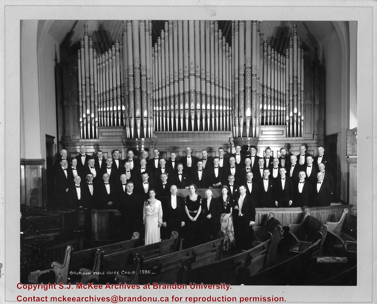
According to Henderson's 1935 Brandon City Directory, the First United Church was located on the corner of 8th Street and Lorne Avenue. The minister at the time was Reverend John H. Garden.
Scope and Content
Photograph shows the Brandon Male Voice Choir dressed in tuxedos and posing before the First United Church's pipe organ. A minister (possibly Rev. John H. Garden) and three women in formal attire are standing in the front row.
Notes
Writing on the back of the photograph reads: return to Bob Hoffman, Box #1, Brandon, R7A 5Y6
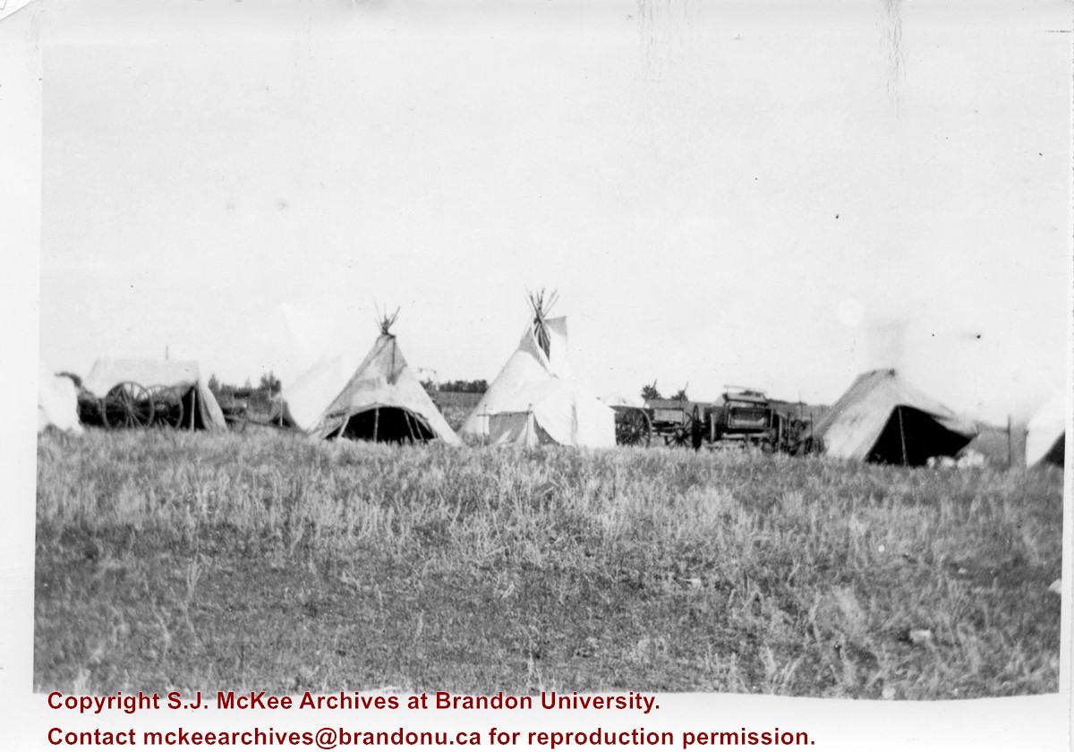
Photograph shows the Aboriginal camp site at the Brandon Fair. Pictured are wagon carts, tipis, and canvas tents.
Notes
Writing on back of photograph reads: 6 prints [20-2009.145 to 20-2009.150]. Indians at the Brandon Fair. Camping off 18th St. back of fair grounds. 1923
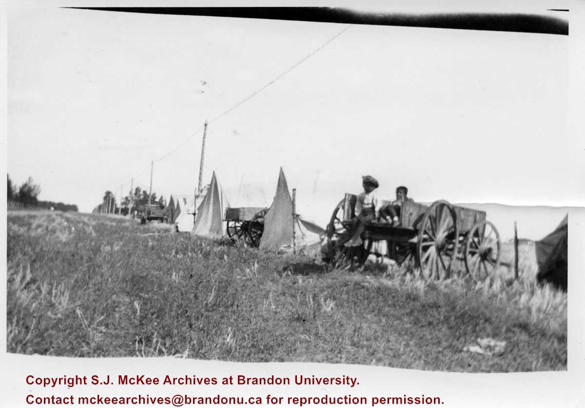
Photograph shows the Aboriginal camp site at the Brandon Fair. Pictured are wagon carts and canvas tents. Two children can be seen sitting in a wagon.
Notes
Writing on back of photograph reads: 6 prints [20-2009.145 to 20-2009.150]. Indians at the Brandon Fair. Camping off 18th St. back of fair grounds. 1923
Photograph shows a group of Aboriginal peoples sitting near a fair building. Several members are dressed in regalia.
Notes
Writing on back of photograph reads: 6 prints [20-2009.145 to 20-2009.150]. Indians at the Brandon Fair. Camping off 18th St. back of fair grounds. 1923
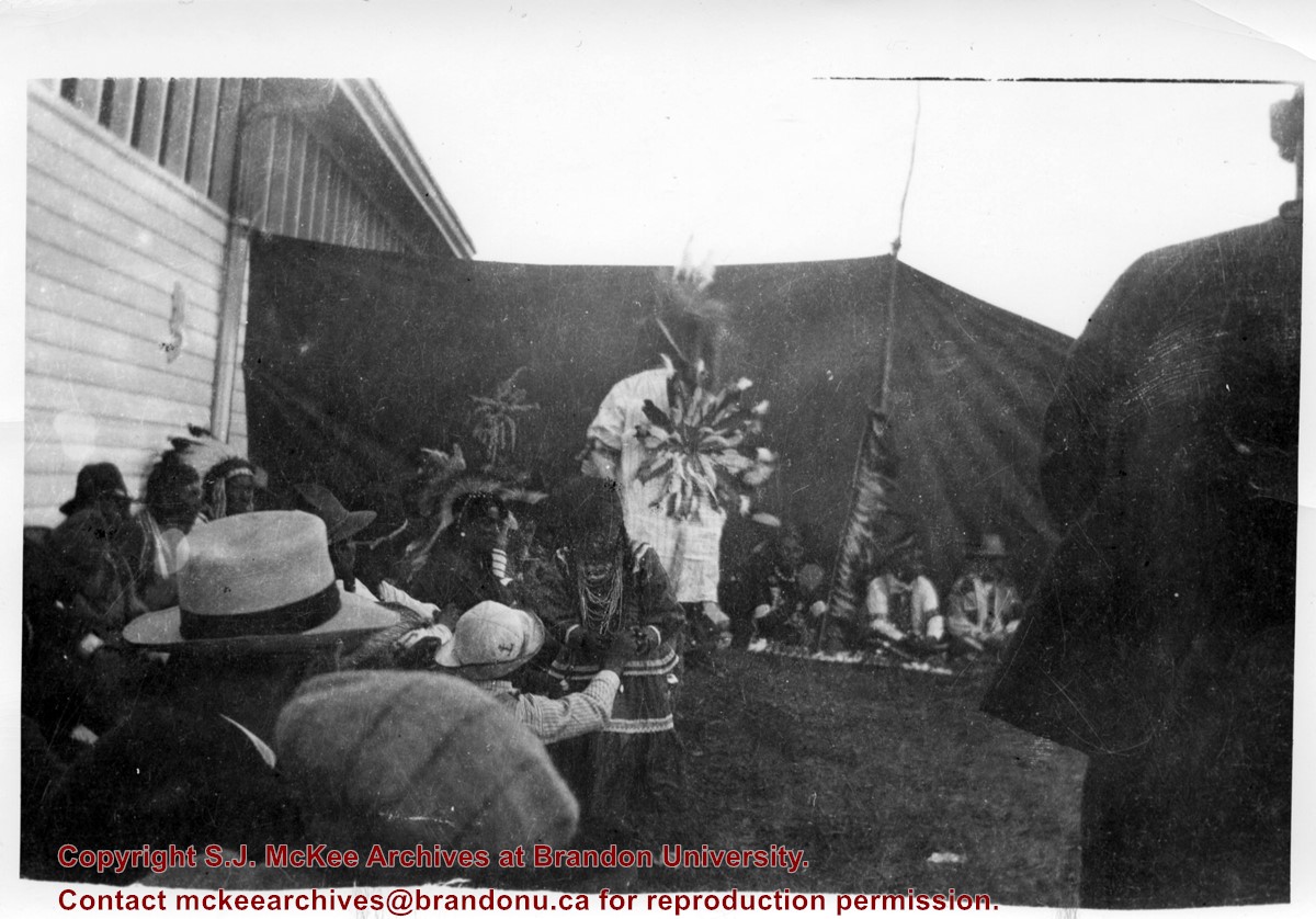
Photograph shows a group of Aboriginal peoples standing in a circle surrounding a group in traditional regalia. An American flag is visible in the foreground.
Notes
Writing on back of photograph reads: 6 prints [20-2009.145 to 20-2009.150]. Indians at the Brandon Fair. Camping off 18th St. back of fair grounds. 1923
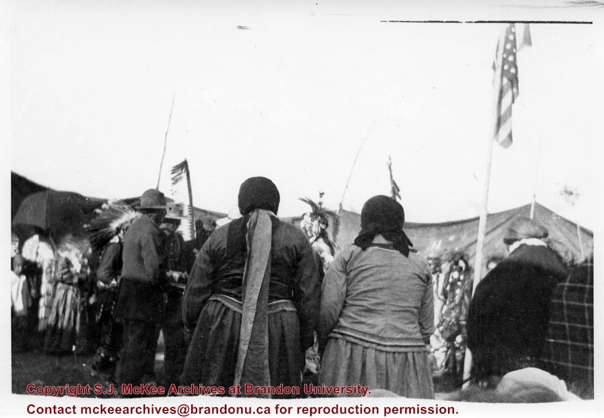
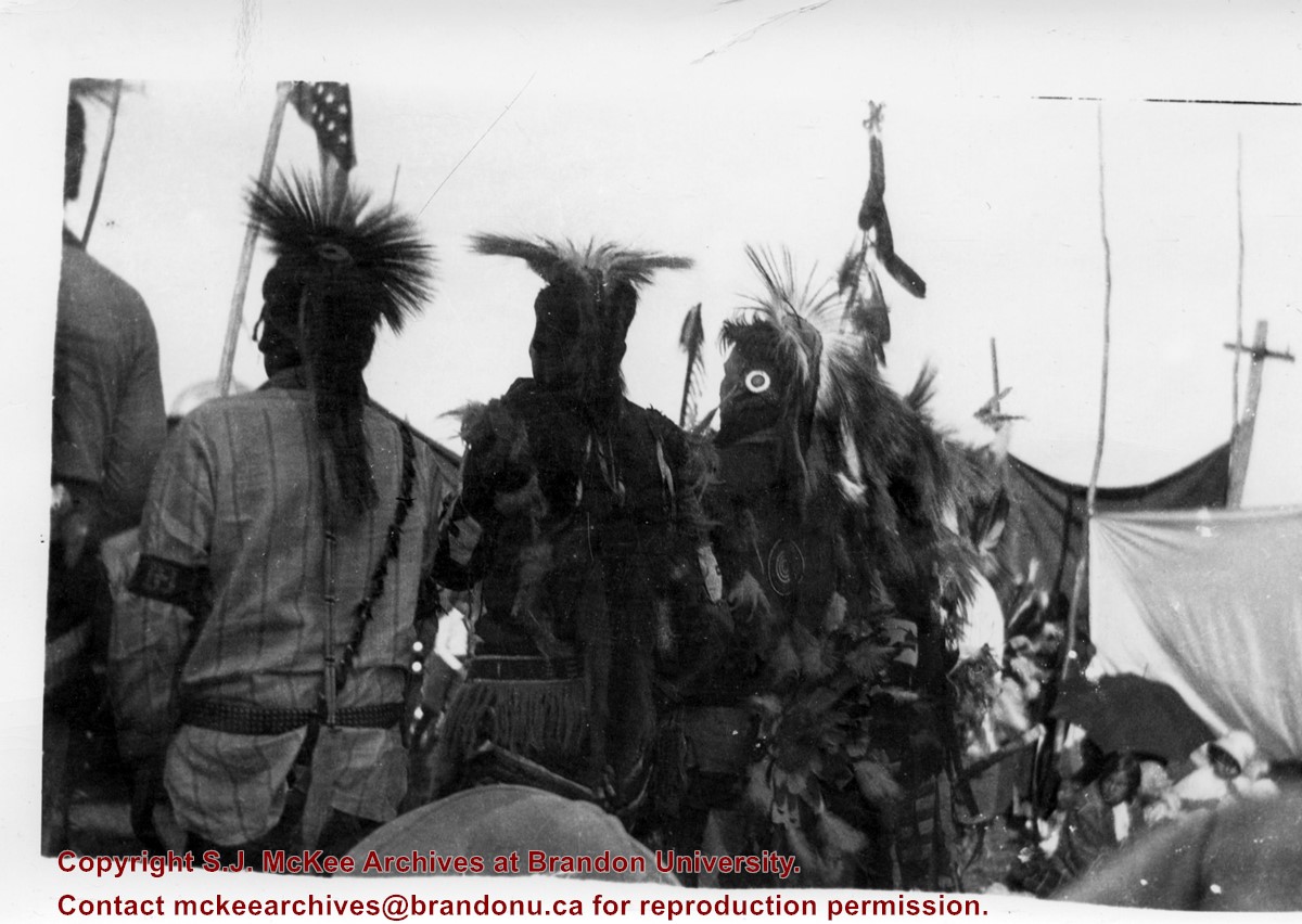
Photograph shows the backside of a group Aboriginal peoples dressed in traditional regalia. An American flag is visible in the background
Notes
Writing on back of photograph reads: 6 prints [20-2009.145 to 20-2009.150]. Indians at the Brandon Fair. Camping off 18th St. back of fair grounds. 1923
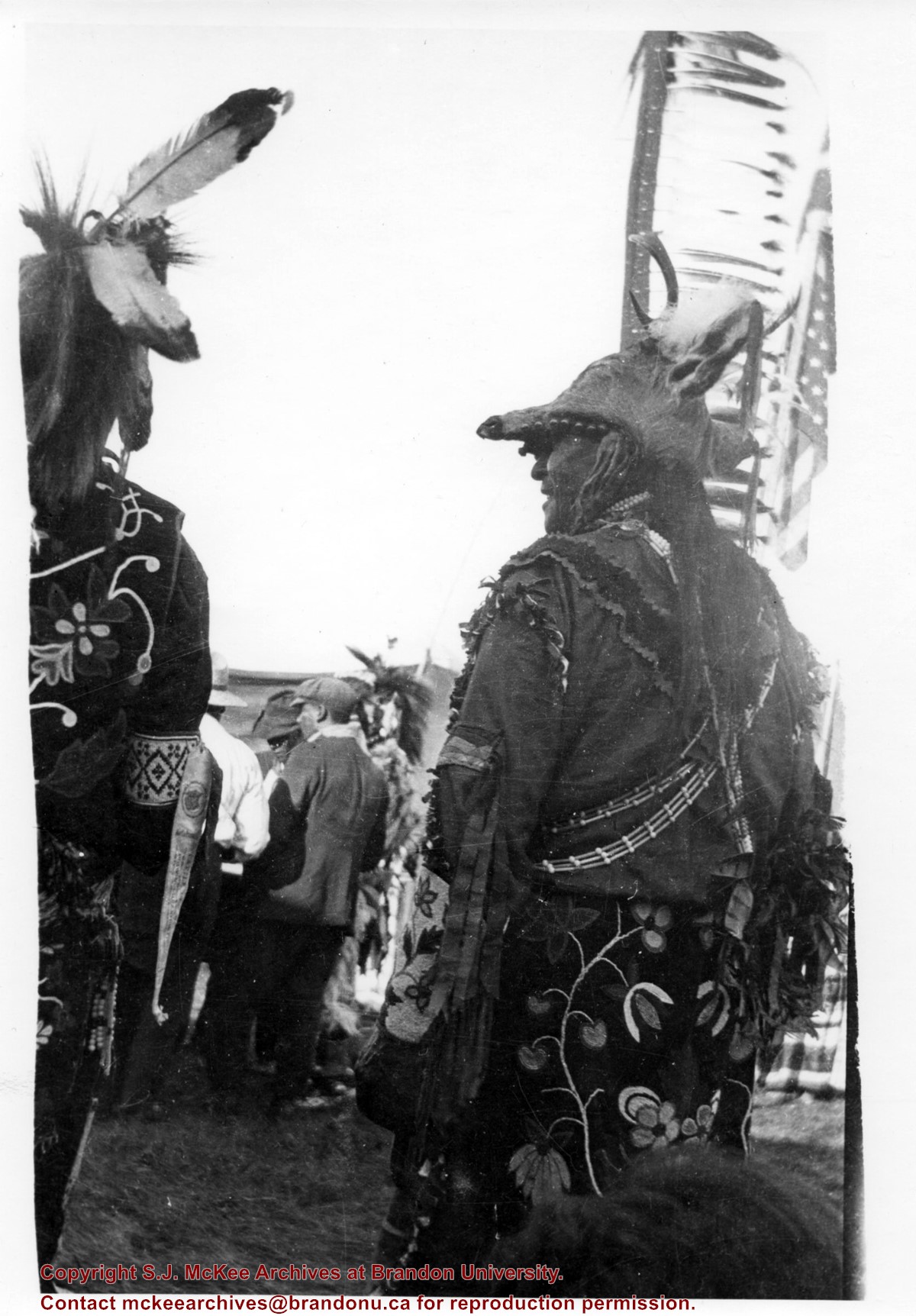
Photograph shows the backside of a pair of Aboriginal men dressed in traditional regalia. Both are wearing beaded clothing and one is wearing a deer head headdress. An American flag is visible in the background
Notes
Writing on back of photograph reads: 6 prints [20-2009.145 to 20-2009.150]. Indians at the Brandon Fair. Camping off 18th St. back of fair grounds. 1923
Photograph shows exterior views of five Brandon churches: Baptist Church, Presbyterian Church, St. Matthew's Church, Catholic Church and Monastery, and Methodist Church.
Notes
Part of "Christie's Brandon Series of Six Colored Picture Postcards of Brandon, Manitoba, The Crown Series, Published by Christie's Bookstore, Brandon, Man." [note: missing sixth postcard]. Writing on the front of the photograph reads: Baptist Church, Presbyterian Church Brandon Man., St. Matthew's Church, Catholic Church and Monastery, Methodist Church.
Photograph shows two separate views. One is of the main entrance of (Old) City Hall on Princess Avenue. The other view shows the ediface of the YMCA building as well as the adjacent St. Paul's United and First United Churches on 8th Street.
Notes
Part of "Souvenir of Brandon, Manitoba, Canada [viewbook], Printed by Photogelatine Engraving Co. Limited, Ottawa." Dates obtained from the Burchill's Music Store Henderson's Brandon City Directory listings (1927-1929). Writing on the front of the photograph reads: City Hall - Brandon, Man; YMCA, St. Paul's United & First Church United, Brandon, Man.
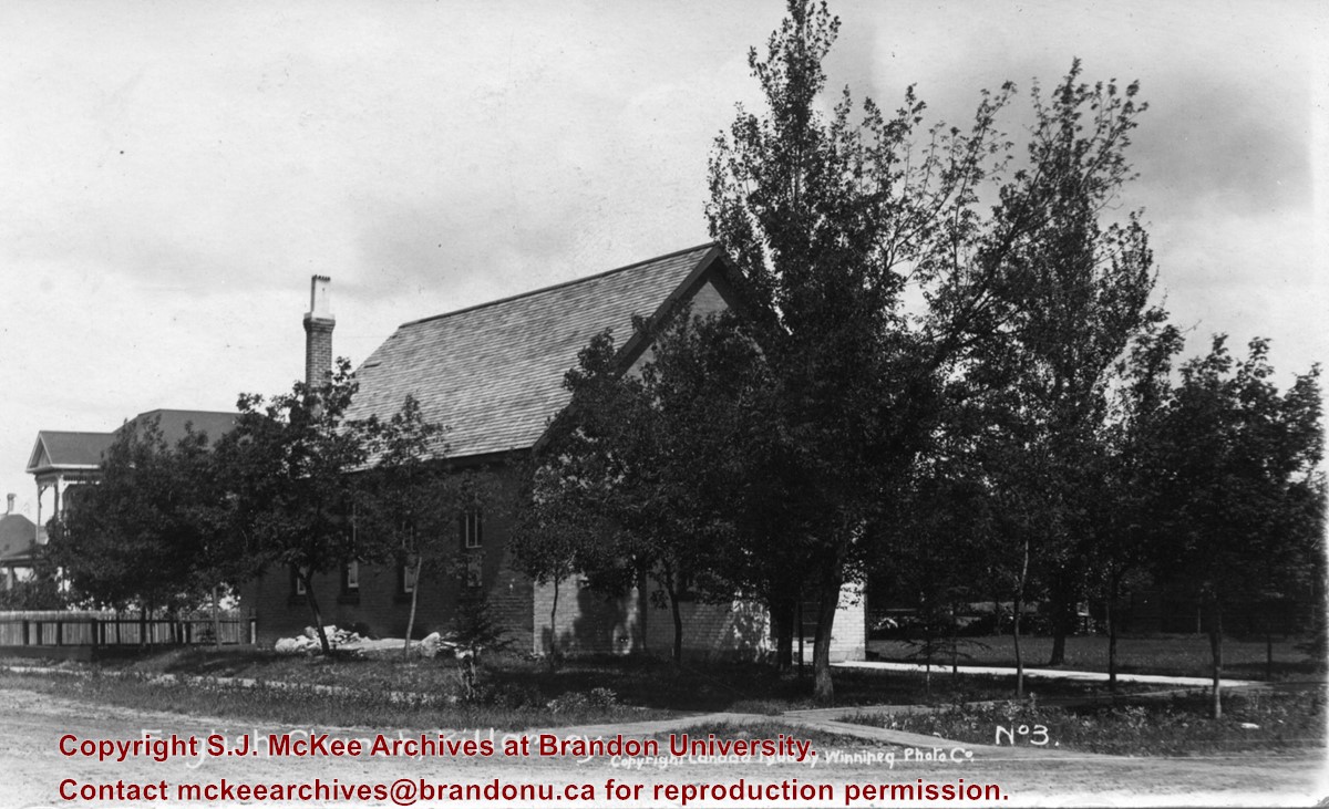
Photograph shows the English Church in Killarney, Manitoba. The entrance to the brick structure is obscured by trees.
Notes
Writing on the front of the postcard reads: English Church, Killarney, Copyright Canada 1908 by Winnipeg Photo Companty, No. 3. Writing on the back of the postcard reads: Photo Post Card by Winnipeg Photo Co., Napinka, Man. The postcard is addressed to Miss Annie Pope of 638 Pacific Avenue, Brandon. A green one cent King George stamp is postmarked Killarney Manitoba 22 July 1908.


