Skip header and navigation

Revise Search

85 records – page 1 of 5.

Ward Watson collection

http://archives.brandonu.ca/en/permalink/descriptions4821
Part Of
RG 5 Western Manitoba Manuscript Collection
Description Level
Collection
GMD
textual records
Date Range
1935-1938
Accession Number
36-1997
Part Of
RG 5 Western Manitoba Manuscript Collection
Description Level
Collection
Accession Number
36-1997
GMD
textual records
Date Range
1935-1938
Physical Description
2 cm
History / Biographical
Ward Watson was born in Brandon, Manitoba and attended Brandon Collegiate Institute in the late 1930's. In 1937, he was chosen out of the student body to attend the Coronation of King George VI in London, England. Watson graduated from the University of Manitoba in 1942. Until his retirement, Watson was an executive with Cargill Grain Company.
Custodial History
This collection was accessioned by the McKee Archives in 1997. Prior custodial history is unknown.
Scope and Content
Collection contains yearbooks from Brandon Collegiate Institute - "The New Era" - for the years 1935 to 1938. The yearbooks include enrollment lists, pictures of classes and sports teams, short essays, editorial gossip, and local advertisments.
Notes
CAIN No. 202630
Subject Access
Brandon Collegiate
The New Era
Brandon
Coronation
high school
Storage Location
1997 accessions
Storage Range
1997 accessions
Show Less
Part Of
Brandon University Photograph collection
Description Level
Item
GMD
graphic
Date Range
c. 1985
Part Of
Brandon University Photograph collection
Description Level
Item
Series Number
2.1
Item Number
BUPC 2.1.60
GMD
graphic
Date Range
c. 1985
Physical Description
5" x 3.5" (colour)
Scope and Content
Photograph shows the removal of one of the houses formerly located on 20th Street between Louise and Princess Avenues. The houses on those blocks were removed to create parking lots for the University. A Fed Zavislak Ltd. Well Drilling & Trucking pickup truck is visible at the curb.
Subject Access
campus photographs
Brandon streets
Images
Show Less
Part Of
Brandon University Photograph collection
Description Level
Item
GMD
graphic
Date Range
c. 1985
Part Of
Brandon University Photograph collection
Description Level
Item
Series Number
2.1
Item Number
BUPC 2.1.61
GMD
graphic
Date Range
c. 1985
Physical Description
5" x 3.5" (colour)
Scope and Content
Photograph shows the removal of one of the houses formerly located on 20th Street between Louise and Princess Avenues. The houses on those blocks were removed to create parking lots for the University.
Subject Access
campus photographs
Brandon streets
Images
Show Less

Aerial view: Brandon College campus

http://archives.brandonu.ca/en/permalink/descriptions8272
Part Of
Aerial views and campus photographs
Description Level
Item
GMD
graphic
Date Range
c. 1964
Part Of
Aerial views and campus photographs
Description Level
Item
Series Number
2.1
Item Number
2.1.1
GMD
graphic
Date Range
c. 1964
Physical Description
4" x 5" (b/w)
Scope and Content
Photograph is looking northwest from approximately the southeast corner of 18th Street and Louise Avenue.
Name Access
Flora Cowan Residence
Subject Access
Aerial views Brandon College
Images
Show Less

Art Gallery of Southwestern Manitoba fonds

http://archives.brandonu.ca/en/permalink/descriptions4857
Part Of
RG 5 Western Manitoba Manuscript Collection
Description Level
Collection
GMD
multiple media
Date Range
1904-1993; predominant 1960-1970
Accession Number
2-1998; 3-2001
Part Of
RG 5 Western Manitoba Manuscript Collection
Description Level
Collection
Accession Number
2-1998; 3-2001
GMD
multiple media
Date Range
1904-1993; predominant 1960-1970
Physical Description
1.2 m
History / Biographical
The Brandon Art Club was founded in November 1907, and operated in an art studio on the top floor of the Brandon College Women's Residence. The club appears to have been the creation of Miss. H. Hancock, who became the Director of the Department of Art at Brandon College c. 1907. The club moved to larger facilities made available at the First Methodist Church; the organization remained there until sometime during the Great War when the club relocated to St. Paul's Presbyterian Church and then in 1921, to the Prince Edward Hotel. The club's first public art exhibitions were held at the Prince Edward Hotel. Art classes were held for the first time in 1928. In 1968, the Brandon Art Club merged with the Allied Arts Center, which had been formed in 1959. The Allied Arts Center was located at 1036 Louise Avenue. In April 1984, the Allied Arts Center was moved to new facilities at the Arts Center of Western Manitoba located at 638 Princess Avenue. In 1989, it was renamed the Art Gallery of Southwestern Manitoba, and began to function as a "professional, regional art gallery." The Art Gallery of Southwestern Manitoba relocated to 2-710 Rosser Ave. c. 2001.
Custodial History
These records were created at different times between 1907 and 1993, and remained in the possession of the administration of the above mentioned organizations until May 2001, when they where donated to the McKee Archives.
Scope and Content
Fonds contains administrative records, minutes, personal files, correspondence, newsletters, photographs, summaries of collections and exhibits, scrapbooks, programs, submitted papers, and other miscellaneous records. All are a record of the growth and evolution of the Art Club, its administration, and of the art community in Brandon.
Notes
CAIN No. 202584
Subject Access
H. Hancock
Brandon Allied Arts Council
Art Gallery of Southwestern Manitoba
Brandon College
Storage Location
1998 accessions
Storage Range
1998 accessions
Related Material
The A.E. McKenzie Company fonds (RG 3 MG 1, 1.3) located in the McKee Archives contains some records, primarily correspondence and minutes, relating to the Brandon Allied Arts Council.
Show Less

Manitoba Genealogical Society fonds

http://archives.brandonu.ca/en/permalink/descriptions4814
Part Of
RG 5 Western Manitoba Manuscript Collection
Description Level
Collection
GMD
textual records
Date Range
c.1880 to c.1980
Accession Number
9-1998
Part Of
RG 5 Western Manitoba Manuscript Collection
Description Level
Collection
Accession Number
9-1998
GMD
textual records
Date Range
c.1880 to c.1980
Physical Description
30 cm
History / Biographical
The Southwest Branch of the Manitoba Genealogical Society was established in 1978. The Branch was formed following a meeting with members of the Manitoba Genealogical Association formed in 1977. The organization was created to assist individuals interested in doing genealogical research through the provision of genealogical data and archival resources. Since its creation the Southwest Branch has also issued a newletter and published a series of cenusus summaries based on the 1901 Canadian census.
Custodial History
These records were donated to the McKee archives in 1990 by J.D. Wall on behalf of the Southwest Branch of the Manitoba Genealogical Society.
Scope and Content
Fonds includes transcripts of the records transcribed from cemetery headstones located in cemeteries throughout southwestern Manitoba. Each transcript includes details about the cemetery records and all details including names, dates, and inscriptions from each headstone. The collection includes a "Cemetery Transcript List" detailing those cemeteries for which transcripts exist. Transcripts include those for the following cemeteries: Alexander, Birdtail Sioux Indian Reserve, Blenheim Church, Glencoe, Boissevain, Brandon, Brandon Hills Church Cemetery, Brookdale, Carberry District, Coultervale, Elgin, Elkhorn, Humesville, Lauder, Kerfoot (Gregg Cemetery), Icelandic Gravesite (Tilston), History of Kingsley Cemetery near Somerset, Madford Cemetery, Old Medora Cemetery, Melgund, Millford Cemetery, Noble Cemetery, Methven , Millord Cemetery, Roseville Anglican Church Cemetery, St. Savior's Anglican Church, St. George's Anglican Church, Rounthwaite, Souris (Glenwood Cemetery), Skalholt, Wellwood, Woodville (Lund, Kola, Bennett, Two Creeks), Patterson (near Nesbitt), Sparling (near Justice), Tilston (near Sinclair), Royal Canadian Air Force Memorial (20 miles north of Rivers).
Notes
CAIN No. 202662
Subject Access
cemetary records
Genealogy
Brandon
Manitoba
Storage Location
1998 accessions
Storage Range
1998 accessions
Show Less

Brandon University campus construction

http://archives.brandonu.ca/en/permalink/descriptions8016
Part Of
Brandon University Photograph collection
Description Level
Item
GMD
graphic
Date Range
c. 1996
Part Of
Brandon University Photograph collection
Creator
Photographer: Sandy Black
Description Level
Item
Series Number
2.1
Item Number
BUPC 2.1.82
GMD
graphic
Date Range
c. 1996
Physical Description
4" x 6" (colour)
Scope and Content
View is northeast from the Brandon College Building. Photograph shows the inside of the Brandon College Building after it had been gutted and then partially rebuilt. The exterior fascade of the west side of the building can be clearly seen in this photograph. A number of houses on the east side of 200 block of 18th Street are also visible, as is the stone fence on Princess Avenue and the flag pole on the front lawn.
Subject Access
campus photographs
campus construction
Brandon streets
Images
Show Less

Northeast corner 10th Street and Princess Avenue, Brandon, Manitoba (1)

http://archives.brandonu.ca/en/permalink/descriptions8372
Part Of
Joseph H. Hughes collection
Description Level
Item
GMD
graphic
Date Range
1962
Accession Number
3-1997
Part Of
Joseph H. Hughes collection
Description Level
Item
Series Number
3-1997.1
Item Number
3-1997.1.3
Accession Number
3-1997
GMD
graphic
Date Range
1962
Physical Description
8" x 10" (b/w)
Physical Condition
good
Scope and Content
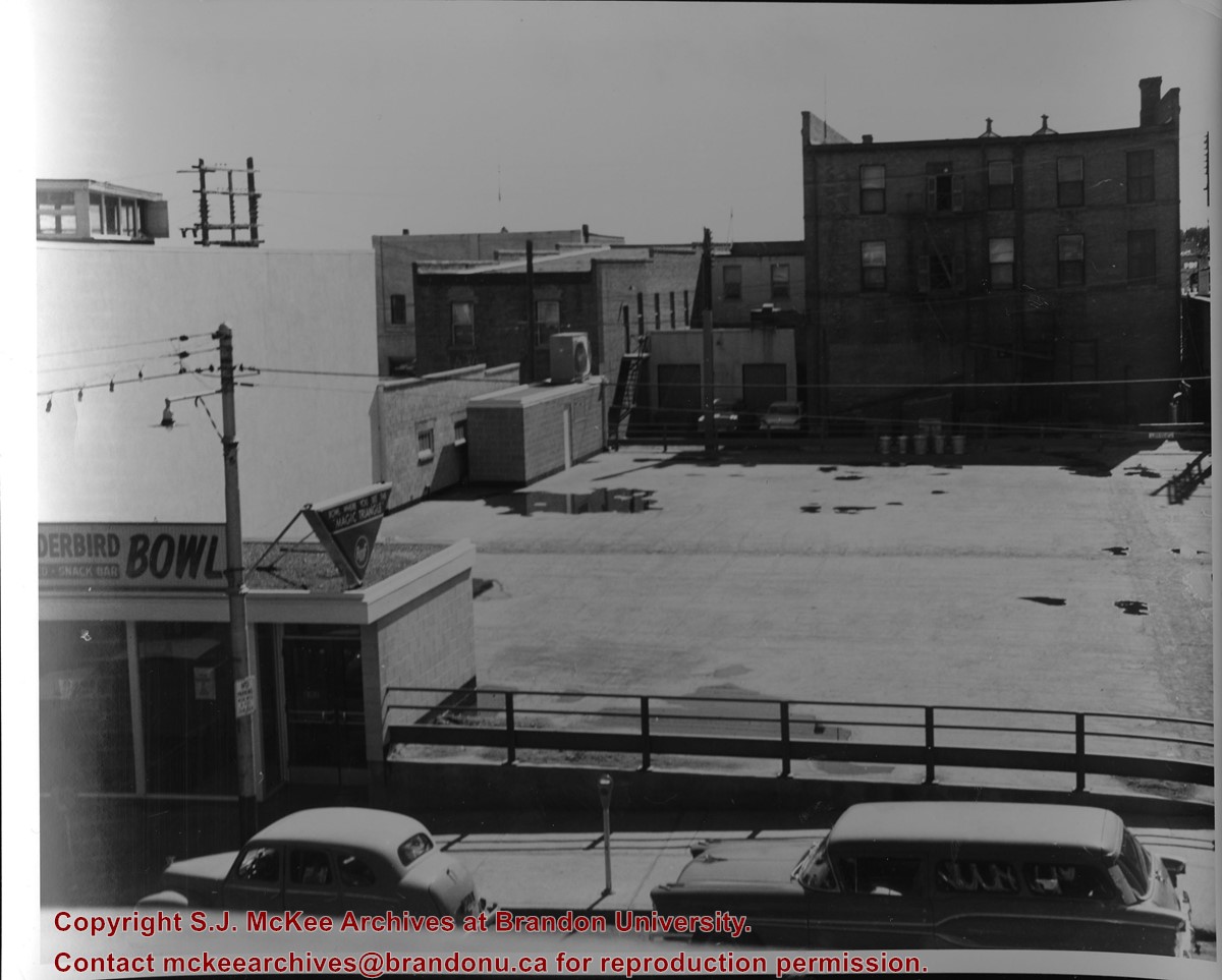
Photograph of an northeast corner 10th Street and Princess Avenue and the rear of buildings facing 200 block on 9th Street. The business in foreground is Thunderbird Bowl. The rear of the Brandon Inn is in the background.
Notes
Photograph dated from "Tara's Bulba," the movie playing at the Strand Theatre and similiar vehicles captured in the photograph.
Name Access
Thunderbird Bowl
10th Street
Subject Access
Brandon business buildings & facilities after 1940
bowling
Storage Location
RG 5 photograph storage drawer
Images
Show Less

Northeast corner 10th Street and Princess Avenue, Brandon, Manitoba (2)

http://archives.brandonu.ca/en/permalink/descriptions8374
Part Of
Joseph H. Hughes collection
Description Level
Item
GMD
graphic
Date Range
1962
Accession Number
3-1997
Part Of
Joseph H. Hughes collection
Description Level
Item
Series Number
3-1997.1
Item Number
3-1997.1.4
Accession Number
3-1997
GMD
graphic
Date Range
1962
Physical Description
8" x 10" (b/w)
Physical Condition
good
Scope and Content
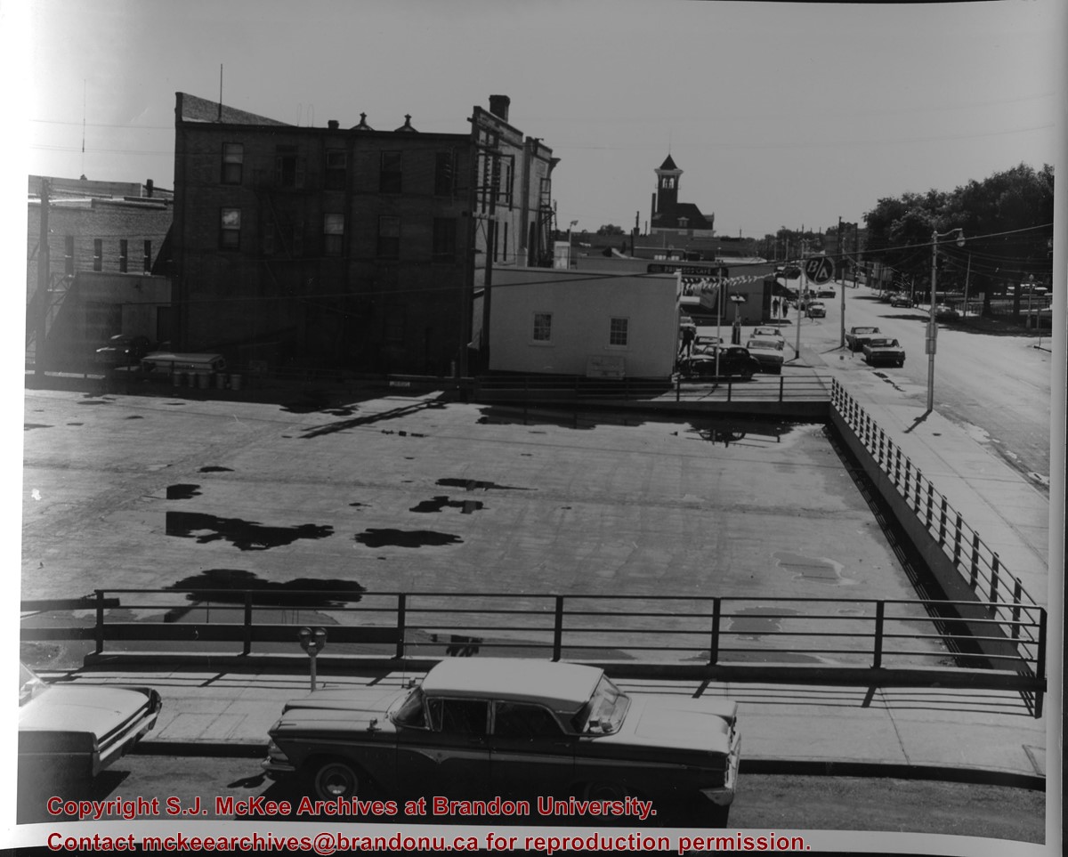
Photograph shows a view of downtown Brandon from the northeast corner of 10th Street and Princess Avenue. Thunderbird Bowl is in the foreground. Painted advertisements on the sides of buildings include: The Mitrou's Cafe and Tea Room and Brandon Musical Supply Ltd. Vehicles parked on 10th Street are facing north.
Notes
Photograph dated from "Tara's Bulba," the movie playing at the Strand Theatre and similiar vehicles captured in the photograph.
Name Access
Thunderbird Bowl
Mitrou Building
Brandon Musical Supply Ltd.
10th Street
Subject Access
downtowns
Brandon business buildings & facilities after 1940
Storage Location
RG 5 photograph storage drawer
Images
Show Less

Aerial view - Brandon University campus

http://archives.brandonu.ca/en/permalink/descriptions7989
Part Of
Brandon University Photograph collection
Description Level
Item
GMD
graphic
Date Range
c. 2000
Part Of
Brandon University Photograph collection
Creator
Photograph commissioned by Brandon University and taken by Yourview Aerial Scenics Ltd.
Description Level
Item
Series Number
2.1
Item Number
BUPC 2.1.55
GMD
graphic
Date Range
c. 2000
Physical Description
6" x 4" (colour)
Scope and Content
View is southwest from approximatley 16th Street between Princess and Rosser Avenues. Photograph shows the Brandon University campus, as well as surrounding residential blocks, including Flemming, J.R. Reid and Vincent Massey schools.
Subject Access
aerial photographs
campus photographs
campus buildings
Brandon streets
Images
Show Less

Aerial view - Brandon University campus

http://archives.brandonu.ca/en/permalink/descriptions7990
Part Of
Brandon University Photograph collection
Description Level
Item
GMD
graphic
Date Range
c. 2000
Part Of
Brandon University Photograph collection
Creator
Photograph commissioned by Brandon University and taken by Yourview Aerial Scenics Ltd.
Description Level
Item
Series Number
2.1
Item Number
BUPC 2.1.56
GMD
graphic
Date Range
c. 2000
Physical Description
6" x 4" (colour)
Scope and Content
View is west southwest from approximatley 16th Street between Princess and Lorne Avenues. Photograph shows the Brandon University campus, as well as surrounding residential blocks between 16th and 23rd Streets, Princess and Louise Avenues..
Subject Access
aerial photographs
campus photographs
campus buildings
Brandon streets
Images
Show Less

Aerial view - Brandon University campus

http://archives.brandonu.ca/en/permalink/descriptions7991
Part Of
Brandon University Photograph collection
Description Level
Item
GMD
graphic
Date Range
c. 2000
Part Of
Brandon University Photograph collection
Creator
Photograph commissioned by Brandon University and taken by Yourview Aerial Scenics Ltd.
Description Level
Item
Series Number
2.1
Item Number
BUPC 2.1.57
GMD
graphic
Date Range
c. 2000
Physical Description
6" x 4" (colour)
Scope and Content
View is west from approximatley 17th Street between Lorne and Louise Avenues. Photograph shows a portion of the Brandon University campus (excluding the Education Building and anything north of it), as well as surrounding residential blocks from approximatley 17th Street to 22nd Street.
Subject Access
aerial photographs
campus photographs
campus buildings
Brandon streets
Images
Show Less

Aerial view - Brandon University campus

http://archives.brandonu.ca/en/permalink/descriptions7992
Part Of
Brandon University Photograph collection
Description Level
Item
GMD
graphic
Date Range
c. 1990
Part Of
Brandon University Photograph collection
Description Level
Item
Series Number
2.1
Item Number
BUPC 2.1.58
GMD
graphic
Date Range
c. 1990
Physical Description
5" x 3.5" (colour)
Scope and Content
View is west northwest from approximatley 16th Street and Louise Avenue. Photograph shows the Brandon University campus, prior to the Library Extension, and a large portion of the city to the west of the campus.
Subject Access
aerial photographs
campus photographs
campus buildings
Brandon streets
Images
Show Less

Aerial view - Brandon University campus

http://archives.brandonu.ca/en/permalink/descriptions7993
Part Of
Brandon University Photograph collection
Description Level
Item
GMD
graphic
Date Range
c. 1990
Part Of
Brandon University Photograph collection
Description Level
Item
Series Number
2.1
Item Number
BUPC 2.1.59
GMD
graphic
Date Range
c. 1990
Physical Description
5" x 3.5" (colour)
Scope and Content
View is northwest from approximatley 16th Street and Louise Avenue. Photograph shows the Brandon University campus, prior to the Library Extension, and a large portion of the city to the west of the campus.
Subject Access
aerial photographs
campus photographs
campus buildings
Brandon streets
Show Less

Brandon University campus construction

http://archives.brandonu.ca/en/permalink/descriptions8005
Part Of
Brandon University Photograph collection
Description Level
Item
GMD
graphic
Date Range
c. 1996
Part Of
Brandon University Photograph collection
Creator
Photographer: Sandy Black
Description Level
Item
Series Number
2.1
Item Number
BUPC 2.1.71
GMD
graphic
Date Range
c. 1996
Physical Description
4" x 6" (colour)
Scope and Content
View is northeast probably from the roof of McMaster Hall. Photograph shows the construction of the new roof on Clark Hall and the Brandon College Building. A portion of the east side of the 000 and 100 blocks of 18th Street, as well as the corner of 18th Street and Rosser Avenue are visible in the upper left hand corner. This includes the "Downtown Brandon" sign.
Subject Access
campus photographs
campus buildings
campus construction
Brandon streets
Images
Show Less

Brandon University campus construction

http://archives.brandonu.ca/en/permalink/descriptions8006
Part Of
Brandon University Photograph collection
Description Level
Item
GMD
graphic
Date Range
c. 1996
Part Of
Brandon University Photograph collection
Creator
Photographer: Sandy Black
Description Level
Item
Series Number
2.1
Item Number
BUPC 2.1.72
GMD
graphic
Date Range
c. 1996
Physical Description
6" x 4" (colour)
Scope and Content
View is north northeast probably from the roof of McMaster Hall. Photograph shows the construction of the new roof on Clark Hall and the Brandon College Building, as well as the construction of the extension to Clark Hall and the skywalk. Portions of the city as far north as the Assiniboine River are also visible.
Subject Access
campus photographs
campus buildings
campus construction
Brandon streets
Images
Show Less

Brandon University campus construction

http://archives.brandonu.ca/en/permalink/descriptions8018
Part Of
Brandon University Photograph collection
Description Level
Item
GMD
graphic
Date Range
c. 1996
Part Of
Brandon University Photograph collection
Description Level
Item
Series Number
2.1
Item Number
BUPC 2.1.84
GMD
graphic
Date Range
c. 1996
Physical Description
6" x 4" (colour)
Scope and Content
View is north northeast from the roof of McMaster Hall. Photograph shows the campus under construction during the renovation of the Brandon College Building and Clark Hall. The photograph was taken in late fall after the roof had been removed from the buildings but before the construction of the extension of Clark Hall. Construction materials litter the courtyard and driveway. The view looking north extends to The North Hill - a number of residential blocks, particularly to the northeast of 18th Street are visible. Buildings include the International Harvester Building and Kin Village.
Subject Access
campus photographs
campus buildings
campus construction
Brandon streets
Images
Show Less

Brandon University campus construction

http://archives.brandonu.ca/en/permalink/descriptions8020
Part Of
Brandon University Photograph collection
Description Level
Item
GMD
graphic
Date Range
c. 1996
Part Of
Brandon University Photograph collection
Creator
Photographer: Sandy Black
Description Level
Item
Series Number
2.1
Item Number
BUPC 2.1.86
GMD
graphic
Date Range
c. 1996
Physical Description
6" x 4" (colour)
Scope and Content
View is north northeast probably from the roof of McMaster Hall. Photograph shows the construction of the new roof on Clark Hall and the Brandon College Building, as well as the construction of the extension to Clark Hall and the skywalk. The view looking north extends to The North Hill - a number of residential blocks, particularly to the northeast of 18th Street are visible. Buildings include the International Harvester Building and Kin Village.
Subject Access
campus photographs
campus buildings
campus construction
Brandon streets
Images
Show Less

Northeast corner 10th Street and Princess Avenue, Brandon, Manitoba (3)

http://archives.brandonu.ca/en/permalink/descriptions8375
Part Of
Joseph H. Hughes collection
Description Level
Item
GMD
graphic
Date Range
1962
Accession Number
3-1997
Part Of
Joseph H. Hughes collection
Description Level
Item
Series Number
3-1997.1
Item Number
3-1997.1.5
Accession Number
3-1997
GMD
graphic
Date Range
1962
Physical Description
8" x 10" (b/w)
Physical Condition
good
Scope and Content
Photograph shows the northeast corner of 10th Street and Princess Avenue facing east. In the background the following Brandon businesses can be seen: back of the Brandon Inn, B/A gas station, The Princess Cafe, and the Central Fire Hall.
Notes
Photograph dated from "Tara's Bulba," the movie playing at the Strand Theatre and similiar vehicles captured in the photograph.
Name Access
Princess Cafe
Central Fire Station
B/A Service Station
Princess Avenue
Subject Access
street scenes
Brandon business buildings & facilities after 1940
Storage Location
RG 5 photograph storage drawer
Images
Show Less

Strand Theatre, Brandon, Manitoba

http://archives.brandonu.ca/en/permalink/descriptions8378
Part Of
Joseph H. Hughes collection
Description Level
Item
GMD
graphic
Date Range
1959
Accession Number
3-1997
Part Of
Joseph H. Hughes collection
Description Level
Item
Series Number
3-1997.1
Item Number
3-1997.1.7
Accession Number
3-1997
GMD
graphic
Date Range
1959
Physical Description
8" x 10" (b/w)
Physical Condition
good
Scope and Content
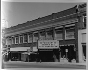
Photograph shows the east side of 10th Street, Brandon, Manitoba. The Strand Theatre marquee shows "Gidget" starring Sandra Dee and Cliff Robertson. Other businesses in the Strand Block include: Ted Heming Jewellers, Waddell's, and Metropolitan Life.
Notes
Photograph dated from "Gidget," the movie playing at the Strand Theatre
Name Access
Strand Theatre
Ted Heming Jewellers
Waddell's
Metropolitan Life
Subject Access
street scenes
Brandon business buildings & facilities after 1940
Storage Location
RG 5 photograph storage drawer
Images
Show Less

85 records – page 1 of 5.