Situated in the R.M. of Whitehead on the Little Saskatchewan River, the 10 Mile Dam was a 14 kilometer transmission line that supplied the city of Brandon with power. The Brandon Electric Light Company built the dam in 1900 and it is considered Manitoba's first hydroelectic power generating station. The dam spanned approximately 80 meters and was constructed from timber and reinforced with clay and stone. The station was decommissioned in 1924.
Scope and Content
Photograph shows 10 Mile Dam, also known as the Brandon Dam or Minnedosa River Hydro Plant.
Notes
Writing on the back of the photograph reads: "10 mile dam". Biographical information obtained from Manitoba Historical Society.
Situated in the R.M. of Whitehead on the Little Saskatchewan River, the 10 Mile Dam was a 14 kilometer transmission line that supplied the city of Brandon with power. The Brandon Electric Light Company built the dam in 1900 and it is considered Manitoba's first hydroelectic power generating station. The dam spanned approximately 80 meters and was constructed from timber and reinforced with clay and stone. The station was decommissioned in 1924.
Alonzo Archibald Rowe (b. 1862, London, ON; d. 22 Oct 1951, Brandon). The Rowes were considered Brandon area pioneers. Alonzo’s father, Alonzo L. Rowe, came to Brandon with his family in 1881, where the family had a furniture and undertaker business on the west side of 10th Street between Rosser and Princess Avenues. In 1885, the family began farming west of Brandon and Alonzo Archibald served as a councilor and then a reeve in the R.M. of Whitehead. He returned to Brandon in 1907 and served with the Brandon Police Department until 1910, when he returned to farming, this time in Arrow River. A.A. Rowe returned to Brandon in 1915 to work as a Provincial Licenses Inspector, a position he held until 1938. (Source: Obituary, Brandon Daily Sun 22 Oct 1951)
Custodial History
Photograph was in possession of Mrs. Ruby Miles, who passed the image on to Fred McGuinness. McGuinness makes reference to Mrs. Miles and this photograph in his Sunbeams column (Source: F.A. Rosser, "Another interesting chat with a daughter of the plains," Brandon Sun 18 Aug 1981).
Scope and Content
Photograph shows four fishermen at 10 Mile Dam, also known as the Brandon Dam or Minnedosa River Hydro Plant. The fishermen in the photo are identified as George H. Rowe and his father A.A. Rowe, Dr. Wilfred Bigelow, and Al Collins.
Notes
Writing on the back of the photograph reads: at Brandon Dam, [right to left] son and father - George H. ROWE, Mr. A.A. ROWE, Dr. BIGELOW, Al COLLINS (dam?, 1906?, George born March 1897); Jerrett's Photo-Services, May 7 1938.
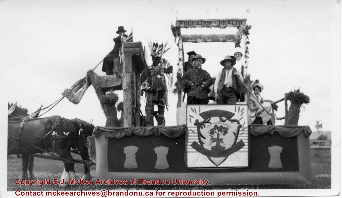
Photograph shows the City of Brandon parade float pulled by two clydesdale horses. The parade is in honour of the diamond anniversary of Canada's Confederation. The float is decorated with wheat sheaves, the city's coat of arms, and the words "education" and "health" adorn a pergola or arbour in the centre of the float. Seven people are on the float and appear to be in costume. An Aboriginal man is dressed in full regalia, one man appears to be in academic robes, another dressed as a farmer. One woman appears to be dressed like a nurse while another may be wearing a pioneer costume.
Notes
Writing on the back of the photograph reads: Brandon City's foat in 1927, Celebrating 60 years of Confederation, The lady in white is Miss Ann Carnahan who was on the city staff for a number of years and now resides in Victoria. She is my husbands [sic.] sister.
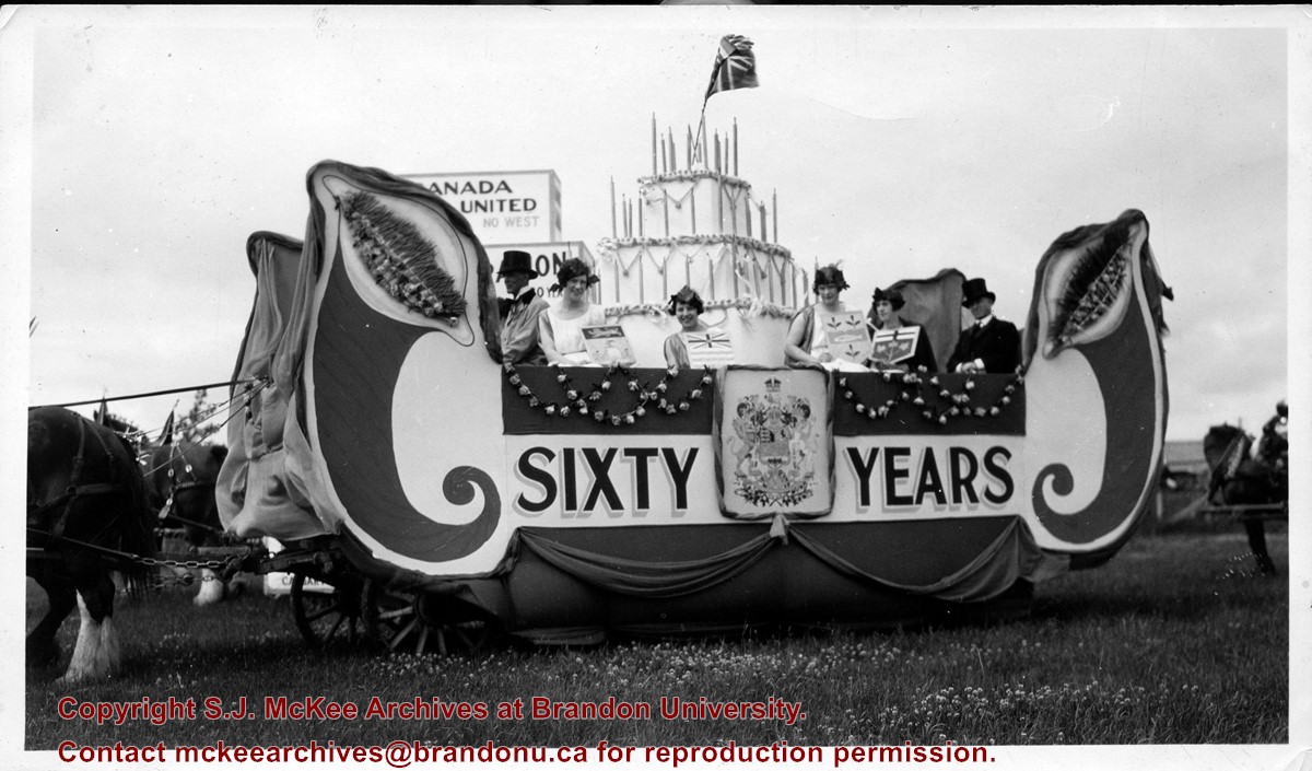
Photograph shows the Mental Hospital parade float pulled by two clydesdale horses. The parade is in honour of the diamond anniversary of Canada's Confederation. The side of the float is decorated with Canada's coat of arms and the words "Sixty Years." In the centre of the float is a three-tiered birthday cake with a Union Jack affixed to its top. Four women are draped in toga-like gowns and each are holding provincial (small) coat of arms for New Brunswick, British Columbia, Nova Scotia, and Ontario. Two men can be seen wearing top hats and coats.
Notes
Writing on the back of the photograph reads: Mental Hospital foat in 1927.
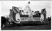
Photograph shows the Timothy Eaton Company's parade float pulled by two clydesdale horses. The parade is in honour of the diamond anniversary of Canada's Confederation. The side of the float reads: Canada's Power in the Affairs of the World. A large globe is strapped to the back of the float and the provincial coat of arms for Prince Edward Island, British Columbia, Nova Scotia, New Brunswick, Quebec, and the Dominion of Canada line the side. The Canadian Red Ensign is mounted at the front of the float.
Notes
Writing on the back of the photograph reads: T. Eaton Co. float, 1927, 60th Anniversary of, Confederation.
According to the Manitoba Historical Society, the Volunteer Monument was unveiled at Winnipeg's Old City Hall on September 28, 1886. The monument commemorated the soldiers of 90th Winnipeg Rifles (also known as the "Little Black Devils") who were killed during the 1885 North West Rebellion. In 1968, the monument was moved to the east side of Main Street, between the Centennial Concert Hall and the Manitoba Museum.
Scope and Content
Photograph shows a parade marching south along Main Street in front of the Volunteer Monument on Winnipeg's Old City Hall grounds (1886-1962). The parade was in honour of Queen Victoria's Diamond Jubilee that was held June 22, 1899. Businesses visible on the west (left) side of Main Street include: the Great Northern Railway Line, Gurney Stove & Range Co., Sherman House, The Arlington Hotel, Hurtley & Co., Central Drug Hall, Inman Optical Co. On the east side of Main Street, the Conferation Life Block is draped with bunting and a large ensign flag is flying from its tower. Specators line the streets and can be seen on roof tops and leaning from windows.
Notes
The front of the photograph reads: Jublee [sic.] Procession June 22/99 Winnipeg
Postcard shows the 100 block of 10th Street facing north. The CPR train station can be seen at the end of 10th Street. The sign for the Rex Cafe is visible on the west side of 10th Street. On the east side of 10th Street, billboards for Campbell & Campbell furniture are visible as well as signs for Pianos and the Orpheum Theatre. Motorists and cyclists share the road. Street car tracks run the length of 10th Street.
Notes
Back of postcard reads: Morning reflection of Brandon's skyline on the Assiniboine River, photo by Sandy Black, printed in Brandno, Manitoba, Canada by Leech Printing Ltd.
Situated in the R.M. of Whitehead on the Little Saskatchewan River, the 10 Mile Dam was a 14 kilometer transmission line that supplied the city of Brandon with power. The Brandon Electric Light Company built the dam in 1900 and it is considered Manitoba's first hydroelectic power generating station. The dam spanned approximately 80 meters and was constructed from timber and reinforced with clay and stone. The station was decommissioned in 1924.
Scope and Content
Photograph shows 10 Mile Dam, also known as the Brandon Dam or Minnedosa River Hydro Plant. The dam's timber construction is quite evident in the picture.
Notes
Writing on the back of the photograph reads: McGuinness (Manitoba Hydro), on Little Saskatchewan.
Kirkham's Bridge was built in 1906, to replace an earlier wooden bridge. The bridge was used until 1981, when it was purchased by the Town of Birtle and moved to a newsite. A former railway pridge was installed in its place.
Scope and Content
Photograph shows Kirkham's Bridge, a steel truss bridge that spanned the Little Saskatchewan River in the Municipality of Riverdale.
Notes
Identification of the bridge provided by Ken Storie (2023). Additional information taken from the Manitoba Historical Society website.
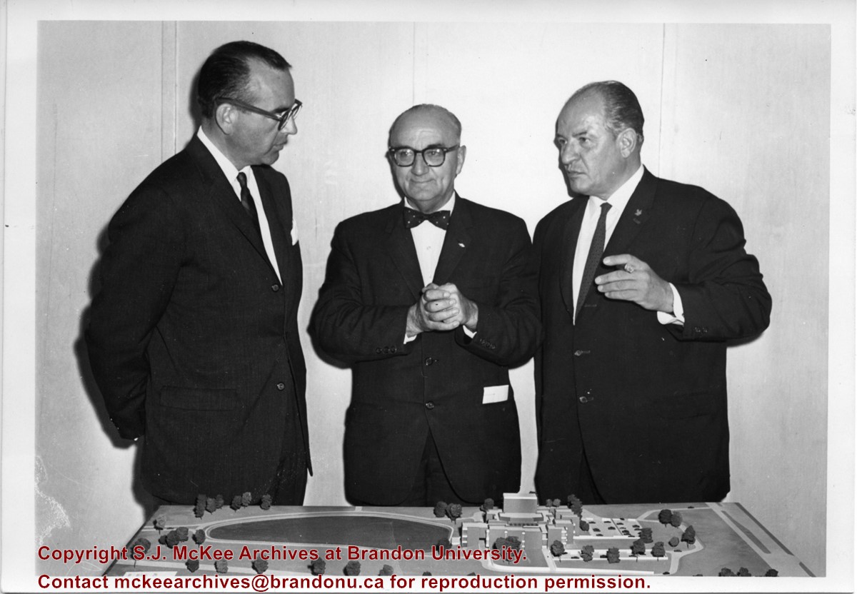
Photograph shows Fred McGuinness standing with Newfoundland Premier Joey Smallwood (centre) and the Centennial Commissioner John Fisher (right). The men are standing before an architectural model.
Notes
Writing on the back of the photograph reads: On tour of Newfoundland as member, board of directors Canadian Centennial Commission, McG, Premier Smallwood, & John Fisher, Centennial Commissioner, 1965
Fleming School, located at 2320 Louise Avenue, Brandon, MB, was a part of the Brandon School Division from its creation in 1914 until its closure in 2005. The school was named to commemorate the life of pioneer Dr. Alexander Fleming. Fleming, who was a Scottish born immigrant, came to Brandon in 1881, where he worked as Brandon's first medical doctor and pharmacist. He also held the role of chairman for the Brandon School Board. Fleming died in Brandon on November 26, 1897.
Rapid population growth in the City of Brandon in the early part of the 20th century resulted in a need for additional school buildings; Fleming School was among the schools established during this period. Designed by W.H. Shillinglaw, the structure was constructed out of concrete, wood and brick, and included a basement. When the school first opened, it was composed of six classrooms; after two renovations in 1953 and 1962, the school expanded with more classrooms and a gymnasium. At the time of its closure, Fleming School could accommodate seven classes, covering grades kindergarten to grade six.
Around 2004, the Brandon School Division decided to close Fleming Elementary School. Prior to the closure a celebration was held on January 14, 2005, to honour the school's 90th Anniversary. Following the school's official closing, students were reallocated to Earl Oxford Elementary School (540 18th Street). Some of the former staff found work in other schools within the Division, while Craig Manson, the last principal of Fleming School, became principle of Green Acres Elementary School.
The building formerly used as Fleming Elementary School became a high school for the Sioux Valley Dakota Nation in late 2006. The Band bought the building in late 2010.
Custodial History
Records were collected and created by Fleming School staff and administration, many for the 90th anniversary and closing of the school. Craig Manson, the last principal of Fleming School, gave the records to David Wilson, who donated them to the S.J. McKee Archives in 2015.
Scope and Content
Collection consists of records that document the history of Fleming School. Many of the records were created and gathered specifically by Craig Manson and others for the school's 90th anniversary; on November 19, 2006 an ad written by Grant Hamilton was placed in the Brandon Sun with Jean Pickard asking for potential archives from Fleming School to be donated by contacting Keith Heide at the Brandon School Division. The archives were to be used in a display on education in Brandon to be located in the Town Centre in June 2007. Other records were collected and created by the school's staff and administration to document the activities and student of their school.
Textual records include newspaper clippings, staff and administration lists (1914-2005), programs, calendars, correspondence, anecdotes, as well as records related to the events surrounding the 90th anniversary and the closure of the school. The 90th anniversary celebration materials include Craig Manson's speech and agenda, the lyrics to the school song, and a list of people in attendance. The newspaper clippings, with capture the experiences of Fleming students, are evidence of the staff's interest in the lives of their current and former students.
Also included in the textual records is in depth genealogical research for the Fleming family. The research includes birth and death dates, photographs of grave sites and residences of Fleming family members, as well as some correspondence around the school's 90th anniversary. The photographs in the album include both originals and photocopies.
Photographs in the collection, like the newspaper clippings, document the activities and events of Fleming School, its students and staff. They include candid's from the classroom, various ceremonies (including the 90th anniversary), and the celebration of holidays (especially Halloween). There are also a number of class and staff portraits.
The collection also includes audio visual materials. The VHS recording entitled "Fleming School 90th Birthday Tea," runs approximately 75 minutes and was videoed by Ian Carkener. The DVD, which runs 42 minutes, was created by the staff and students for the 90th anniversary celebration. It has three components: "Through the Decades" shows students re-enacting school scenes from earlier decades; "Students at Work and Play," shows the 2004-2005 students in their classroom environment during holiday celebrations, school ceremonies and working on assignments; and "Reflections," which includes a slide show of photographs of Fleming School throughout the years set to music.
Finally, the collection includes four artifacts: one 90th anniversary celebration balloon with an image of the school building and the its years of operation printed on it; a school magnet with the school phone number and an image of the brick school building; and two pins. The first pin is circular with a black background and gold details including the school's name, three silhouettes and three maple leaves. The second pin appears to have a hornet or bee emblem with the number 72.
Notes
History/bio information was taken from the records, as well as the Manitoba Historical Society's website (Alexander Fleming, Fleming School - accessed on September 30, 2016), the Brandon School Division website (Fleming School - accessed on September 30, 2016) and Grant Hamilton's article "Gathering school archives while they can" (Brandon Sun, November 19, 2006). Description by Megan Treloar (September 2016) and Christy Henry.
John C. Cousins was the son of Thomas Cousins (b. August 17, 1882 in Truro, Nova Scotia - d. March 5, 1914) and Mary Margaret Craig (b. April 14, 1824 - d. April 25, 1903). He married Eunice Eliza Nixon from London Township, County of Middlesex, Ontario. Together they had three children: Eunice M., Eric O. and Kathleen. J.C. Cousins was Reeve of the Rural Municipality of Daly from 1905 to 1910 and Assessor for the Town of Rivers from 1931-1938.
Custodial History
Record was accessioned in 2007 by the McKee Archives. Prior custodial history unknown.
Scope and Content
This document is a rambling memoir of John C. Cousins' recollections of life in the Rural Municipality of Daly from the settlement era in the early 1880s, through to the 1940s. He touches on various themes, including: his family history; the activities of the R.M. of Daly and his role as Reeve; the history of school districts in the municipality (lists names of first teachers and early students); the history of churches in the municipality; tragedies in the municipality; lists members of the Council of the municipality for the years 1885-1946; and the devastating impact of the Spanish Influenza on Aboriginal people in the municipality.
In addition, the memoir includes documentary records, such as minutes and copies of letters. There are also many photographs of both events and individuals (virtually all of the photographs are labelled and names are provided). The memoir goes beyond a simple recounting of facts. Cousins is discursive and thoughtful, often making references to developments happening in other parts of North America and Canada. There is also a link to the Maritimes, from which his family originated.
For history/bio information see the collection level description of the Lawrence Stuckey collection.
Custodial History
For custodial history see the collection level description of the Lawrence Stuckey collection.
Scope and Content
Series consists of slides created from photographs taken by Lawrence Stuckey during his travels throughout Manitoba, other parts of Canada and the United States. Although Lawrence and his wife Mavis travelled for pleasure, their destinations were often chosen deliberately to enable Lawrence to explore and photograph specific landscapes, flora and fauna.
The Snye was a former channel (oxbow lake) of the Assiniboine River. It was located south of the Assiniboine between about 14th and 24th Streets, and during high water in the spring it carried overflow. For many years it was used as a log storage area for Hanbury's Mill. I remember there being bridges over it at 18th & 22nd Streets. It was dammed with a one way flipper valve at 14th Street that allowed water to flow out to the river, but prevented river water backing into it. Water within the Snye became stagnant in summer and formed a breeding area for mosquitoes. It was deemed a health hazard and the river was gradually filled in. LAS.
Custodial History
For custodial history see the collection level description of the Lawrence Stuckey collection.
Scope and Content
Snye River
Notes
[This negative was produced using a previous published image. P.E. 22/07/09]
Additional historical information provided by the Fred McGuinness collection (20-2009).
Erected by the village of Wawanesa, the memorial is dedicated to the local citizens who died as a result of the First and Second World Wars. It was unveiled on November 11, 1921.
Scope and Content
Photograph shows the dedication of a war memorial in the village of Wawanesa, MB. The memorial is located near the bank of the Souris River. The photograph was taken from Wawanesa Mutual. The street on the left is 4th Street.
Notes
History/Bio information taken from the Canadian National Defense website.


