Photograph shows the Brandon Wheat Market along Pacific Avenue on November 30, 1885. Farmers can be seen driving wagon teams loaded with bags of grain in line on Pacific Avenue from 10 Street to at least 7th Street. On the north side of Pacific Avenue the CPR Land Office and grain elevators are pictured. On the south side of Pacific Avenue, the general merchant/hardware store Bower, Blackburn, Mundell & Porter is situated on the corner of Pacific Avenue and 10th Street. A 10th Street sign is affixed to the merchants' store. On the east side of the general store, Edie House, the Grand View Hotel, and a Farmers' boarding and lodging house can be seen. Most of the buildings appear to be woodframed except for the Grand View, which is constructed of brick. Sidewalks appear to be in place on the south side of Pacific and snow dusts the streets. A baby swathed in winter clothing sits in a pram/baby carriage in front of the general store.
Notes
Writing on the front of the photograph reads: Novemeber 30th, 1885, Brandon Wheat Market
The 1901 Canadian Census places the Lehigh family near Brockville, Ontario, where Everett E. Lehigh (b. 19 May 1881) was farming with his widowed father Solon (b. 20 Aug 1849) and younger sister, Edna (b. 08 Feb 1884). The findagrave.com genealogical website identifies a Mary Wickware as marrying Everett E. Lehigh in Alqonquin, Ontario, on 04 April 1905.
E.E. Lehigh appears in the Henderson's Brandon City Directories in 1919. By 1923, he was Vice-President of Motors Ltd., which had its shop on 151-7th Street. By 1925, Lehigh had taken over the garage, renaming it Lehigh Motors, which became the sole agent for McLaughlin Motor Cars. By 1927, Lehigh Motors had opened a second branch on 12th Street and Princess Avenue, which was formerly the Brandon Auto Garage. Lehigh had become the exclusive dealer for McLaughlin-Buick, Pontiac, and Oldsmobile motor cars.
It appears Lehigh moved his business, E.E. Lehigh Ltd., to 799 Pacific Avenue by 1929. By then, Lehigh had a head office in Winnipeg at 640 Portage Avenue where he served as president and was the provincial distributor for Rugby trucks and Durant cars. Although E.E. Lehigh had a residence in Brandon (325 - 14th Street), Mr. S.G. Cunningham was listed as the Brandon representative for Lehigh Motors Ltd. in the Henderson Directories. By 1931, E.E. Lehigh Ltd. had moved once again, this time to 151-153 - 9th Street.
E.E. Lehigh disappears from the Henderson's Brandon City Directory by 1933 and a Mrs. E.E. Lehigh (possibly Mary (Wickware) Lehigh, d.21 July 1943) is listed under the 14th Street residence. The 9th Street garage address is divided between Munns Taxi (151-9th Street) and Wheat City Auto Wreckers (153-9th Street.)
Custodial History
Photograph was in possession of Mrs. Ruby Miles, who passed the image on to Fred McGuinness. McGuinness makes reference to Mrs. Miles and this photograph in his Sunbeams column (Source: F.A. Rosser, "Another interesting chat with a daughter of the plains," Brandon Sun 18 Aug 1981).
Scope and Content
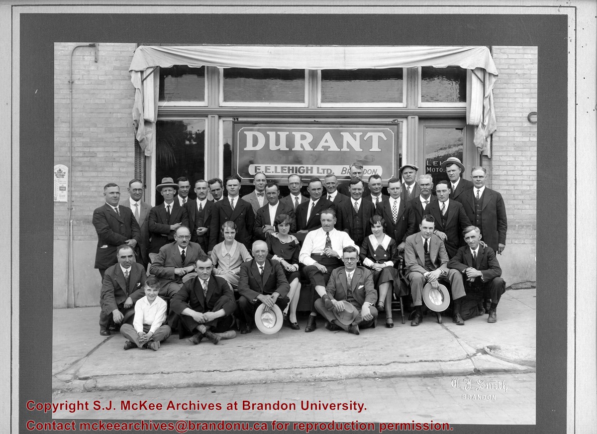
Photograph shows a group portrait of 33 individuals standing and seated in front of the business E.E. Lehigh Ltd., Brandon. The storefront window has a sign that reads: Durant Motor Cars, E.E. Lehigh Ltd., Brandon. The door to the business has Lehigh Motors stencilled on the window. The men are wearing jackets and ties, and there are three women, possibly clerical staff, wearing 1920s era dresses. The elderly man seated in the centre of the photograph, wearing a long-sleeved white dress shirt might be Everett E. Lehigh.
Notes
Writing on the front of the photograph is embossed: C.J. Smith
The Medicine Hat Exhibition and Stampede Parade Day was held on Thursday, July 19, 1962, at 9:30 a.m. The local newspaper reported that approximately 24,000 people were in attendance to see parade marshall Rod Ashburner leading 175 entries consisting of 90 floats, 75 horses, and 10 bands. There were 19 parade categories eligible for $12,000 in prize money and included: junior and senior cowboys and cowgirls; fancy and Shetland ponies; sulky class open; comic, commercial, industrial and organizational floats; decorated cars; special ranch class; 4-H Clubs; and a non-competitive class.
The parade route started at Second St. and Allowance Ave., from Second St. to Ash Ave., north on Ash to First St. SE., from First St. S.E. to Fourth Ave., south to Second St. to South Railway St., south on South Railway St. to Third St., with a finish at McLeod Trail. A route map was published in the Medicine Hat News the day before the parade.
Aerial photographs of the parade were taken by Medicine Hat News photographer Howard Heid (1930-2005) from the private helicopter of John Bourn. Bourn was a pilot from Woodville, Wisconsin, who chartered his four-seater helicopter for sight-seers at exhibitions and stampedes across the county.
(Sources: Pat Currie, "Let 'Er Go!," Medicine Hat News, 19 July 1962,1; Harald Gunderson, "'Eye in the Sky' Best Parade View," Medicine Hat News, 19 July 1962,1; "Parade Starts at 9:30 Sharp," 18 July 1962)
Scope and Content
Photograph shows an aerial view of the Medicine Hat Exhibition and Stampede Parade route with a focus on the First Street SE. A number of gas stations and garages are visible along this route and include Texaco, Shell, Ford, and B/A. The Fraternal Order of Eagles lodge is also visible.
Notes
This photograph appeared on the front page of The Medicine Hat News (19 July 1962).
The Medicine Hat Exhibition and Stampede Parade Day was held on Thursday, July 19, 1962, at 9:30 a.m. The local newspaper reported that approximately 24,000 people were in attendance to see parade marshall Rod Ashburner leading 175 entries consisting of 90 floats, 75 horses, and 10 bands. There were 19 parade categories eligible for $12,000 in prize money and included: junior and senior cowboys and cowgirls; fancy and Shetland ponies; sulky class open; comic, commercial, industrial and organizational floats; decorated cars; special ranch class; 4-H Clubs; and a non-competitive class.
The parade route started at Second St. and Allowance Ave., from Second St. to Ash Ave., north on Ash to First St. SE., from First St. S.E. to Fourth Ave., south to Second St. to South Railway St., south on South Railway St. to Third St., with a finish at McLeod Trail. A route map was published in the Medicine Hat News the day before the parade.
Aerial photographs of the parade were taken by Medicine Hat News photographer Howard Heid (1930-2005) from the private helicopter of John Bourn. Bourn was a pilot from Woodville, Wisconsin, who chartered his four-seater helicopter for sight-seers at exhibitions and stampedes across the county.
(Sources: Pat Currie, "Let 'Er Go!," Medicine Hat News, 19 July 1962,1; Harald Gunderson, "'Eye in the Sky' Best Parade View," Medicine Hat News, 19 July 1962,1; "Parade Starts at 9:30 Sharp," 18 July 1962)
Scope and Content
Photograph shows an aerial view of the Medicine Hat Exhibition and Stampede Parade route with a focus on the First Street SE and and the South Railway Street merge. A number of gas stations and garages are visible along this route and include Texaco, Shell, Ford, and B/A. The Fraternal Order of Eagles lodge is also visible.
Notes
This photograph shows the neighbourhood before rezoning and commercial development.
The Medicine Hat Exhibition and Stampede Parade Day was held on Thursday, July 19, 1962, at 9:30 a.m. The local newspaper reported that approximately 24,000 people were in attendance to see parade marshall Rod Ashburner leading 175 entries consisting of 90 floats, 75 horses, and 10 bands. There were 19 parade categories eligible for $12,000 in prize money and included: junior and senior cowboys and cowgirls; fancy and Shetland ponies; sulky class open; comic, commercial, industrial and organizational floats; decorated cars; special ranch class; 4-H Clubs; and a non-competitive class.
The parade route started at Second St. and Allowance Ave., from Second St. to Ash Ave., north on Ash to First St. SE., from First St. S.E. to Fourth Ave., south to Second St. to South Railway St., south on South Railway St. to Third St., with a finish at McLeod Trail. A route map was published in the Medicine Hat News the day before the parade.
Aerial photographs of the parade were taken by Medicine Hat News photographer Howard Heid (1930-2005) from the private helicopter of John Bourn. Bourn was a pilot from Woodville, Wisconsin, who chartered his four-seater helicopter for sight-seers at exhibitions and stampedes across the county.
(Sources: Pat Currie, "Let 'Er Go!," Medicine Hat News, 19 July 1962,1; Harald Gunderson, "'Eye in the Sky' Best Parade View," Medicine Hat News, 19 July 1962,1; "Parade Starts at 9:30 Sharp," 18 July 1962)
Scope and Content
Photograph shows an aerial view of the Medicine Hat Exhibition and Stampede Parade route with a focus on the First Street SE and Sixth Avenue intersection. A number of gas stations and garages are visible along this route and include Texaco, Shell, Ford, and B/A. A number of observers can be seen sitting on rooftops.
Notes
This photograph shows the neighbourhood before rezoning and commercial development.
The Medicine Hat Exhibition and Stampede Parade Day was held on Thursday, July 19, 1962, at 9:30 a.m. The local newspaper reported that approximately 24,000 people were in attendance to see parade marshall Rod Ashburner leading 175 entries consisting of 90 floats, 75 horses, and 10 bands. There were 19 parade categories eligible for $12,000 in prize money and included: junior and senior cowboys and cowgirls; fancy and Shetland ponies; sulky class open; comic, commercial, industrial and organizational floats; decorated cars; special ranch class; 4-H Clubs; and a non-competitive class.
The parade route started at Second St. and Allowance Ave., from Second St. to Ash Ave., north on Ash to First St. SE., from First St. S.E. to Fourth Ave., south to Second St. to South Railway St., south on South Railway St. to Third St., with a finish at McLeod Trail. A route map was published in the Medicine Hat News the day before the parade.
Aerial photographs of the parade were taken by Medicine Hat News photographer Howard Heid (1930-2005) from the private helicopter of John Bourn. Bourn was a pilot from Woodville, Wisconsin, who chartered his four-seater helicopter for sight-seers at exhibitions and stampedes across the county.
(Sources: Pat Currie, "Let 'Er Go!," Medicine Hat News, 19 July 1962,1; Harald Gunderson, "'Eye in the Sky' Best Parade View," Medicine Hat News, 19 July 1962,1; "Parade Starts at 9:30 Sharp," 18 July 1962)
Scope and Content
Photograph shows an aerial view of the Medicine Hat Exhibition and Stampede Parade route, with a focus on Second Street SE. Visible store signs include: Gardener's Used Cars, Provincial Treasury Branch, Furvey's Furniture and Appliances, J.J. Moore & Son Furniture, Alberta Credit Jewellers, James Richardson & Sons, Medicine Hat Gas Power Water City Owned Utilities.
Notes
This photograph shows the neighbourhood before rezoning and commercial development.
Jack Stothard was born on February 16, 1932 in Brandon, MB. He attended public schools in the city (Central School, Park School, and Earl Oxford) and graduated from Brandon Collegiate Institute (BCI). Stothard married Velma Pollock in 1957 and together they had two daughters: Debra and Kimberly. Stothard was employed in the plumbing and heating business until 1960, when he joined Manitoba Hydro. In the course of his employment with Manitoba Hydro, he became Station Superintendent of the Brandon Generating Station. Stothard retired in 1995. Stothard was a member of the Canadian Numismatic Association, the Canadian Association of Token Collectors and the Toronto Postcard Club. Jack Stothard died on November 3, 2021 in Brandon, MB.
Custodial History
Accession 1-2003 was in the possession of Stothard until donated to the McKee Archives in 2003. Accession 12-2006 was acquired by Lawrence Stuckey at some point after the photograph was taken. Stuckey later sold a copy of the photograph. This copy was later acquired by Jack Stothard in the course of his collecting of Brandon postcards. Stothard donated the image to the McKee Archives in 2004. Accession 8-2007 was prepared by Jack Stothard in the course of 2007. He provided a copy to the Archives upon its completion. Accession 8-2008 was in the possession of Fred McGuinness until he gave jit to Jack Stothard in February 2008. Stothard donated the records to the McKee Archives on February 12, 2008. Accession 18-2008 was donated to the McKee Archives by Stothard on August 18, 2008. Accession 11-2009 was donated to the McKee Archives by Stothard on February 20, 2009. Accession 4-2012 was donated to the McKee Archives by Stothard on August 24, 2011. Accession 4-2013 was donated to the McKee Archives by Stothard in March 2013. Accession 8-2016 was donated to the McKee Archives by Stothard on January 21, 2015.
Scope and Content
Accession 1-2003 contains brief research reports prepared by Stothard on various topics concerning historical Brandon. These include: a listing of hotels, inns and motels that have operated in Brandon since the 1880s; reports dealing with the Café Aagard, Central United Church, the 1913 Dominion Exhibition, Brandon, the Empire Hotel, Brandon’s Central Steam Heating System, the Post Office and the Clement Block. It also contains one booklet: Facts About Brandon: An Industrial Survey of the City of Brandon. Winnipeg: Department of Industry and Commerce [n.d.]
Accession 12-2006 consists of one photograph of the Great Northern Engine 208, built by Rogers Locomotive Company 1887. Cylinders 18 x 24, Drivers 63". G.N. line Church's Ferry, N.D. to Brandon, Manitoba. Opened 1906, Closed 1936.
Accession 8-2007 consists of a brief typed report entitled "The Day the Lights Went Out in Brandon - Strike of 1919" by Jack Stothard. Document provides an account of the sources and delivery of hydro electric power to Brandon beginning in the early 1900s and the brief power outage at the beginning of the Brandon General Strike May 25, 1919.
Accession 8-2008 consists of "The Brandon Sun Challenge Cup" ledger, which contains two b/w photographs, newspaper clippings and information on the history and first race (1908) of the cup; 3 additional b/w photographs of different races; and the Brandon Old Timers Association record book (c. 1900).
Accession 18-2008 consists of a copy of Stothard's Brandon Postcards index. The index is divided into various sub-headings and consists of colored reproductions of postcards in Stothard's collection. The index contains pages that were discarded by Stothard as he updated his inventory, therefore the index is only up to date as of August 18, 2008.
Accession 11-2009 consists of a typed research report entitled "Brandon Police Department Stations and Locations" by Jack Stothard. The report outlines the location of the Brandon Police Department from 1882 - 2008, and also includes a section on "What the Future Holds."
Accession 4-2012 consists of pages for Stothard's Brandon Postcards index (18-2008) and a photocopy of a Brandon Municipal Railway ticket.
Accession 4-2013 consits of eight binders of handwritten notes/facts about Brandon compiled by Jack Stothard. The notes are a collection of names, places, things, events and items related mostly to the first 100 years of Brandon (1882-1982), although the notes continue into the 2000's. Some notes centre on the late 1930's to early 1950's during the period of Stothard's youth. The information in the binders was taken from a variety of publications, while some notes are Stothard's own comments. A list of sources, as well as a cross reference index for all eight binders, can be found in Book No. 1.
The accession includes: Book No. 1 - Notes of Brandon (A to B); Book No. 2 - Notes of Brandon (C to F); Book No. 3 - Notes of Brandon (G to O); Book No. 4 - Notes of Brandon (P to Z); Book No. 5 - Notes of Brandon: Churches, Hostpitals, Hotels; Book No. 6 - Notes of Brandon: Police Department, Fire Department; Book No. 7 - Notes of Brandon: Brandon City Council, City of Brandon etc.; Book No. 8 - Notes of Brandon: Brandon College/University, Brandon Schools, ACC, Brandon School Board. Accession also includes pages from Stothard's Brandon Postcards index (18-2008).
Accession 6-2016 consists of local history books, pamphlets, bakery tokens, local magazines, one binder containing handwritten notes/facts about Brandon compiled from the Brandon Sun's "Looking Back" column, and an accordian file box containing newspaper clippings about Brandon.
The accession includes the following local history books: Betty Watson's "One Day in Brandon Manitoba 9/9/99" (Brandon, Manitoba: Bart Art Books, 1999); P.N. Breton's "Popular Illustrated Guide to Canadian Coins, Medals, &. &.," (Winnipeg: Canadian Numismatic Publishing Institute, 1963 [reprint]); "Facts About Brandon: An Industrial Survey of the City of Brandon," (Province of Manitoba: Department of Industry and Commerce, [1946]); The Polish Gymnastic Association Sokol's "75th Anniversary: From the Past to the Future!" ([Brandon, Manitoba: Polish Gymnastic Association Sokol, 1988]); and Brandon Kinsmen Club's "'Together...Once Again': A History of the Kinsmen Club of Brandon, Manitoba, 1925-1975 (Brandon, Manitoba: The Historical Committee of the Kinsmen Club of Brandon, 1975).
Pamplets and magazines include: Brandon Generating Station (1957) and (1969), The Brandon Quota Club presents...A Century in Revue (1982), Canadian Rail No. 168/July-August 1965 [featuring Brandon Municipal Railway], Prairie City Issue No. 3/1994, and Prairion May/June 1997.
The binder is titled Book No. 9 - "Year by year: miscellaneous items from 1969 to 2000"; an asterik (*) indicates notes have been made on each subject or item in the other Books. Each section is housed in
The files in the accordian file box have been rehoused and include the following topics: banks, Brandon 125 beer, Behlen Industries, breweries, Brandon Shoppers' Mall, calendars, Canadian Motors Ltd., Canexus/Nexen, Canada Games - Summer and Winter, Canadian Tire, CKX Radio & TV/CKLQ, Corral Centre, flour mills, hospitals, Keystone, Maple Leaf, Fred McGuinness, miscellaneous, A.E. McKenzie, people, railways, Simplot, Westman Recycling (new facility), weather-storms-floods, and extra copies of postcards.
Notes
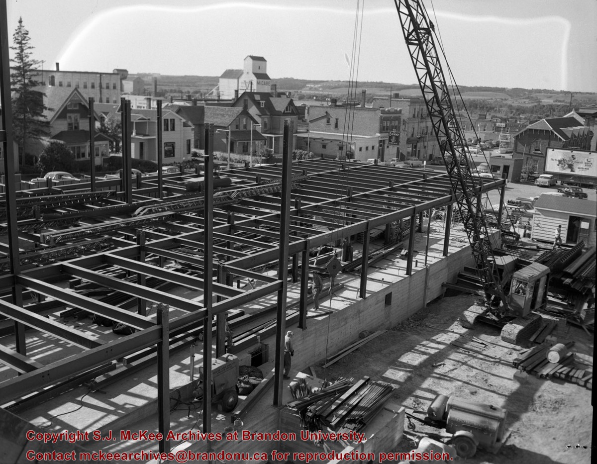
Description by Christy Henry. Accession 4-2013: Book No. 1 contains a photocopied photograph of Aagaard's Cafe, photographs of the Dominion Bank and Barney's Drive Inn and a photo reproduction of the Bass Building. Book No. 2 contains a photograph of the Provincial Goal. Book No. 3 contains photographs of T. Eaton Company (4 construction photos) and a photo reproduction of tents on the Exhibition grounds (c. 1940). Book No. 4 contains photoraphs of the Oak Theatre and Western Motors. There are also photopied photographs of The Fun Shop.
The Franklin Cooperative Elevator Association Ltd was located in Franklin, Manitoba. The association was formed and incorporated on May 19, 1927 under certificate # 68 of the Cooperative Association Act. The first provisional meeting was held on June 27, 1927 with R.A Storey as Chairman and O. Douglas as Secretary. There was a meeting held after the incorporation meeting and the first board of directors was elected on June 28, 1927 with R. A Storey as Chairman and E.A White as Secretary. The cooperative was run by an elected board of directors.
The Franklin Cooperative Elevator Association was a part of the Manitoba Pool Elevators Ltd which was a subsidiary elevator company of the Manitoba Wheat Pool. Manitoba Pool Elevators was incorporated on April 9,1925 with 1,000 000 capitol stocks being sold for $1.00 per share. Manitoba Pool elevators ran on the principal of local ownership through the cooperatives.
The Franklin Cooperative Elevator Association was involved in issues on a local and provincial scale. An example of local concerns was that in October 1948, it is on record that it was a bad crop year with a delayed harvest because of inclement weather. The elevators become plugged up and as a result grain had to be shipped to oppositional elevators. In 1952 the Franklin Cooperative Elevator Association built a forty five thousand bushel annex building and later that year issues arose over cost overages in its construction. The cooperative was also concerned about provincial matters such as on Sept 18, 1952 a strike was arranged by the workers of Manitoba Pool. It was averted when a settlement was reached in Winnipeg.
Custodial History
Records in accession 10-2013, were delivered to the Archives of Manitoba on March 20, 1970 by Bob Douglas, son of Oliver Douglas. Those records were deaccessioned by the Archives of Manitoba in January 2012 and transferred to the McKee Archives later that year. All other records were donated to the McKee Archives by Manitoba Pool Elevators.
Scope and Content
Fonds consists of ledger books containing minutes of monthly meetings as well as annual general meetings for the Franklin Co-operative Elevator Association. The first meeting had thirty members in attendance. From incorporation the cooperative had a list of objectives they wanted to accomplish including building or acquiring, and payment of a grain elevator and building documentation. They also needed to be licensed under the Canadian Grain Act. The ledger books also contains a list of bylaws. Records also included membership rosters and contract numbers for shipping grain. Auditor's year-end financial records are also included in the fonds. Attendance records from 1958 to 1963 have been recorded.
Franklin Co-operative Elevator Association Limited Organizational papers: 1929 - 1961 Certificate of indebtedness, 31 July 1929 Memo re: association, By-laws 8-11, no date Application for share of stock, 31 July 1931 Minutes of Directors meeting, 31 July 1931 Minutes of Shareholders meeting, 31 July 1931 By-law nos. 12 and 13, 31 July 1931 Agreement between Franklin CEA, MPE, Manitoba Wheat Pool and The King, 1 August 1931 By-law no. 14, 12 November 1931 Certificate for one share of stock, 1 December 1931 Letter re: stock acceptance, 14 January 1932 Agreement between Franklin CEA and MPE, 1 February 1933 Special Board of Directors meeting re: By-law no. 15, 16 February 1933 Letter re: By-law no. 14, 18 February 1938 Agreement between MPE and Fraklin CEA, 30 November 1948 Agreement between MPE and Franklin CEA, 1 August 1951 Memo re: above agreement, 13 June 1952 By-law no. 23, 2 November 1951 MPE By-laws 1961-148, 1961-149, 1961-150, 1961-151, 12 October 1961 Directors' Resolution, 18 October 1961 Minutes of Executive Board meetings, 1 August 1969 - 10 December 1982 Minutes of Shareholders Annual meetings, 1929 - 1967 (13 reports) Financial records and statistics Statement of surplus, 1937 - 1955 (15 reports) Final statements, 1934 - 1952 (16 reports) Auditors' reports, 1928 - 1968 (33 reports) Analysis of Operating Results, 1951 - 1963 (9 reports) Review of Operating Results, 1960 - 1966 (5 reports) Detail of grain earnings, 1963 - 1968 (4 reports) Analysis of Operating Results, 1951 - 1952 (5 reports) Statement of grain account and handle, 15 June 1931 Annual financial statement, no date Correspondence, 1927 - 1962 Membership list, 1935 - 1962 Miscellaneous Directors' attendance lists, 1945 - 1959 (8 reports) Directors' attendance lists, 1980 Corporate Name: Rural Municipality of Rosedale; local Pool Committee minutes February 21, 1983 - July 4, 1991.
Notes
Administrative history taken from the records. Description by Jill Sutherland (2010) and Barb Manko (October 2013).
Photograph shows Western Motors Ltd. on the southwest corner of 10th Street and Princess Avenue. Anglo gas station is part of the car shop, which sells GM, Chevrolet, and Oldsmobiles.
Hutchings' Drugs is on the ground floor of the Hughes Building on the northwest corner of 10th Street and Princess. Manufacturers Life occupies the second storey.
Photograph shows the north face of the Prince Edward Hotel on Princess Avenue. To the east of the hotel is Old City Hall with the military monument (which has since been relocated to the Brandon Armoury). On the west side of the hotel is Wheelers Esso Service Station.
Notes
The photograph appears to be taken from the Hughes Building on 10th Street.
Photograph shows Princess Avenue facing east from 10th Street. On the north side of Princess Avenue, a B/A Service Station, Princess Cafe, Lindenberg Seeds, and the Central Fire Station are visible. Old City Hall with the war memorial and the Prince Edward Hotel are visible on the south side of Princess Avenue. Traffic is travelling one-way on Princess Avenue.
Photograph shows the Greyhound Bus Depot at 11th Street and Princess Avenue. Western Motors, Wheelers Esso Station, and the Prince Edward Hotel are visible along the south side of Princess Avenue. Traffic is travelling one-way on Princess Avenue.


)
)
)
)