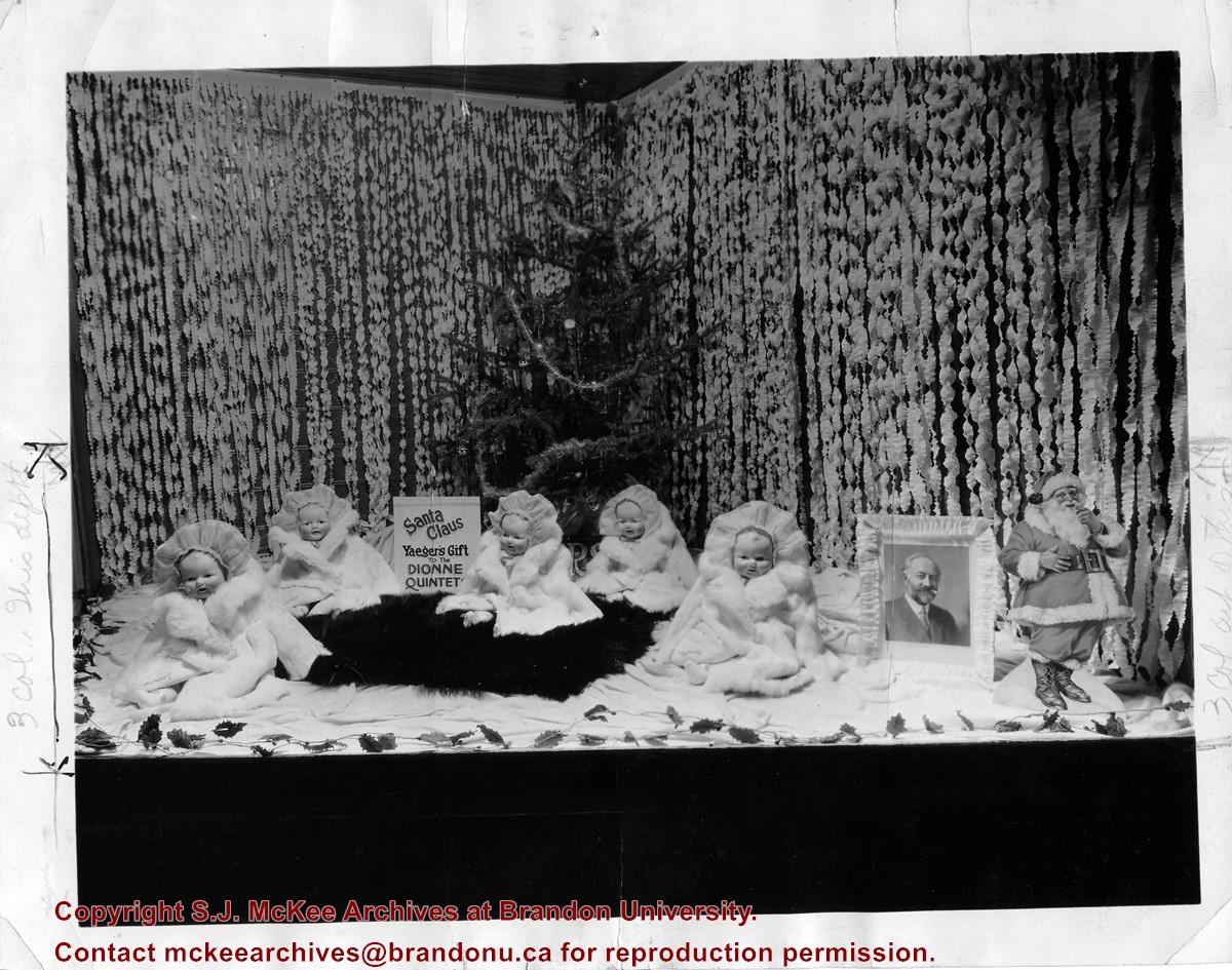
Gustave Bellegro “Gus” Yaeger was born on July 10, 1878 at Genoa, Italy. The son of Swiss parents, he immigrated to the United States, working in West Virginia then North Dakota before arriving in Brandon, MB in 1910. He worked at various jobs before opening Yaeger's Furs, a fur-coat factory and retail store at 602 Rosser Avenue, in 1919.
Yaeger married Sarah Ellen Williams (1883-1966) of Big Rock, Idaho in 1907. They had two children: Karl Williams Yaeger (1908-1975) and Barbara Yaeger (m. H.H. Ricketts).
Gus Yaeger died on March 25, 1942 in Brandon, MB. His son carried on the business after his death before selling it to one of the managers in 1969.
The Dionne quintuplets, born May 28, 1934, were the first quintuplets known to have survived their infancy. They were born just outside Callandar, ON.
Scope and Content
Item is a photograph of the Yaeger's Furs Dionne quintuplets Christmas window display. The display features five dolls dressed in fur coats and bonnets, a framed photo of Gus Yaeger, a Christmas tree and a cardboard Santa.
Notes
History/Bio information taken from the Manitoba Historical Society website (http://www.mhs.mb.ca/docs/people/yaeger_gb.shtml)
View is southwest from approximatley 16th Street between Princess and Rosser Avenues. Photograph shows the Brandon University campus, as well as surrounding residential blocks, including Flemming, J.R. Reid and Vincent Massey schools.
View is west southwest from approximatley 16th Street between Princess and Lorne Avenues. Photograph shows the Brandon University campus, as well as surrounding residential blocks between 16th and 23rd Streets, Princess and Louise Avenues..
View is west from approximatley 17th Street between Lorne and Louise Avenues. Photograph shows a portion of the Brandon University campus (excluding the Education Building and anything north of it), as well as surrounding residential blocks from approximatley 17th Street to 22nd Street.
View is west northwest from approximatley 16th Street and Louise Avenue. Photograph shows the Brandon University campus, prior to the Library Extension, and a large portion of the city to the west of the campus.
View is northwest from approximatley 16th Street and Louise Avenue. Photograph shows the Brandon University campus, prior to the Library Extension, and a large portion of the city to the west of the campus.
Photograph shows a backhoe digging a sewer hole near the sidewalk between the Brandon College Building and the Citizens' Science Building. The Knowles-Douglas Students' Union Centre, John R. Brodie Science Centre and a portion of the driveway are visible in the background.
View is northwest from the roof of the John R. Brodie Science Centre. Photograph shows the roof of the Knowles Douglas Students' Union Centre, the Citizens' Science Building, and the Brandon College Building and Clark Hall during renovation.
View is southwest from the roof of the George T. Richardson Centre. Photograph shows the curved glass wall of the John E. Robbins Library, the walkway between the Library and the Dining Hall, the Dining Hall and Darrach Hall.
View is north probably from the roof of McMaster Hall. Photograph shows the construction of the new roof on Clark Hall and the Brandon College Building.
View is north probably from the roof of McMaster Hall. Photograph shows the construction of the extension to Clark Hall and the skywalk. Also visible are the A.E. McKenzie Building, the Brandon College Building, the Education Building, the original Music Building and the Western Manitoba Centennial Auditorium, as well as the walkway that runs north between the buildings and the courtyard.
View is northeast probably from the roof of McMaster Hall. Photograph shows the construction of the new roof on Clark Hall and the Brandon College Building. A portion of the east side of the 000 and 100 blocks of 18th Street, as well as the corner of 18th Street and Rosser Avenue are visible in the upper left hand corner. This includes the "Downtown Brandon" sign.
View is north northeast probably from the roof of McMaster Hall. Photograph shows the construction of the new roof on Clark Hall and the Brandon College Building, as well as the construction of the extension to Clark Hall and the skywalk. Portions of the city as far north as the Assiniboine River are also visible.
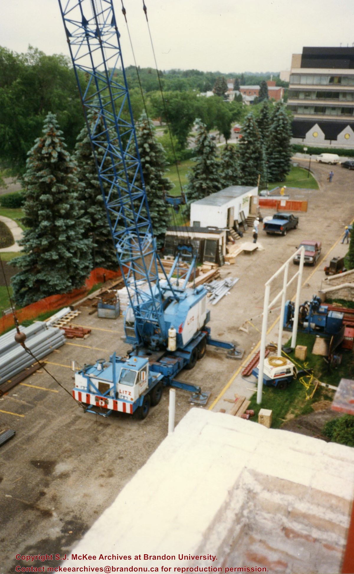
View is southeast from Clark Hall. Photograph shows a large crane, building materials and machines and the construction trailer (Bird Construction) on the driveway during the restoration of Clark Hall and the Brandon College Building. Portions of the front lawn, the John R. Brodie Science Centre and the Knowles Douglas Students' Union Centre are also visible. In the distance is Knox United Church.
View is northwest from Clark Hall. Photograph shows construction materials in the area between Clark Hall and the A.E. McKenzie Building during winter. The Western Manitoba Centennial Auditorium is visible in the upper right hand corner.
View is south southeast from the skywalk. Photograph shows the courtyard in winter full of vehicles, machines and building materials. Also visible are the Development and Physical Plant H-Huts, the Citizens' Science Building, the John R. Brodie Science Centre and McMaster Hall.
View is northwest from the roof of the Brandon College Building. Photograph was taken through wire fencing and shows construction on the roof of the Brandon College Building during winter. The original Clark Hall entrance to the roof is clearly visible. Portions of the A.E. McKenzie Building, Clark Hall and the Western Manitoba Centennial Auditorium are visible in the background.


