Skip header and navigation

Revise Search

18 records – page 1 of 1.

Aerial view: Brandon College from 23rd Street

http://archives.brandonu.ca/en/permalink/descriptions602
Part Of
Brandon University Photograph collection
Description Level
Item
GMD
graphic
Date Range
[1963-1966]
Part Of
Brandon University Photograph collection
Description Level
Item
Series Number
2.1
Item Number
BUPC 2.1.9
GMD
graphic
Date Range
[1963-1966]
Physical Description
5" x 4" (b/w)
Scope and Content
Image is looking east northeast from approximately the 300 block of 23rd Street between Lorne and Louise Avenues. Photograph shows the Brandon College campus after the opening of the original Music Building in 1963, but before the construction of the Education Building in 1966. A number of house on the 300 blocks of 22nd and 21st Streets are visible in the foreground, with the A.E. McKenzie Seed Co., the Prince Edward Hotel and various grain elevators on the horizon.
Subject Access
aerial photographs
campus photographs
campus buildings
Brandon streets
Grain elevators
Images
Show Less

Aerial view - Brandon University campus

http://archives.brandonu.ca/en/permalink/descriptions7989
Part Of
Brandon University Photograph collection
Description Level
Item
GMD
graphic
Date Range
c. 2000
Part Of
Brandon University Photograph collection
Creator
Photograph commissioned by Brandon University and taken by Yourview Aerial Scenics Ltd.
Description Level
Item
Series Number
2.1
Item Number
BUPC 2.1.55
GMD
graphic
Date Range
c. 2000
Physical Description
6" x 4" (colour)
Scope and Content
View is southwest from approximatley 16th Street between Princess and Rosser Avenues. Photograph shows the Brandon University campus, as well as surrounding residential blocks, including Flemming, J.R. Reid and Vincent Massey schools.
Subject Access
aerial photographs
campus photographs
campus buildings
Brandon streets
Images
Show Less

Aerial view - Brandon University campus

http://archives.brandonu.ca/en/permalink/descriptions7990
Part Of
Brandon University Photograph collection
Description Level
Item
GMD
graphic
Date Range
c. 2000
Part Of
Brandon University Photograph collection
Creator
Photograph commissioned by Brandon University and taken by Yourview Aerial Scenics Ltd.
Description Level
Item
Series Number
2.1
Item Number
BUPC 2.1.56
GMD
graphic
Date Range
c. 2000
Physical Description
6" x 4" (colour)
Scope and Content
View is west southwest from approximatley 16th Street between Princess and Lorne Avenues. Photograph shows the Brandon University campus, as well as surrounding residential blocks between 16th and 23rd Streets, Princess and Louise Avenues..
Subject Access
aerial photographs
campus photographs
campus buildings
Brandon streets
Images
Show Less

Aerial view - Brandon University campus

http://archives.brandonu.ca/en/permalink/descriptions7991
Part Of
Brandon University Photograph collection
Description Level
Item
GMD
graphic
Date Range
c. 2000
Part Of
Brandon University Photograph collection
Creator
Photograph commissioned by Brandon University and taken by Yourview Aerial Scenics Ltd.
Description Level
Item
Series Number
2.1
Item Number
BUPC 2.1.57
GMD
graphic
Date Range
c. 2000
Physical Description
6" x 4" (colour)
Scope and Content
View is west from approximatley 17th Street between Lorne and Louise Avenues. Photograph shows a portion of the Brandon University campus (excluding the Education Building and anything north of it), as well as surrounding residential blocks from approximatley 17th Street to 22nd Street.
Subject Access
aerial photographs
campus photographs
campus buildings
Brandon streets
Images
Show Less

Aerial view - Brandon University campus

http://archives.brandonu.ca/en/permalink/descriptions7992
Part Of
Brandon University Photograph collection
Description Level
Item
GMD
graphic
Date Range
c. 1990
Part Of
Brandon University Photograph collection
Description Level
Item
Series Number
2.1
Item Number
BUPC 2.1.58
GMD
graphic
Date Range
c. 1990
Physical Description
5" x 3.5" (colour)
Scope and Content
View is west northwest from approximatley 16th Street and Louise Avenue. Photograph shows the Brandon University campus, prior to the Library Extension, and a large portion of the city to the west of the campus.
Subject Access
aerial photographs
campus photographs
campus buildings
Brandon streets
Images
Show Less

Aerial view - Brandon University campus

http://archives.brandonu.ca/en/permalink/descriptions7993
Part Of
Brandon University Photograph collection
Description Level
Item
GMD
graphic
Date Range
c. 1990
Part Of
Brandon University Photograph collection
Description Level
Item
Series Number
2.1
Item Number
BUPC 2.1.59
GMD
graphic
Date Range
c. 1990
Physical Description
5" x 3.5" (colour)
Scope and Content
View is northwest from approximatley 16th Street and Louise Avenue. Photograph shows the Brandon University campus, prior to the Library Extension, and a large portion of the city to the west of the campus.
Subject Access
aerial photographs
campus photographs
campus buildings
Brandon streets
Show Less

Brandon University campus construction

http://archives.brandonu.ca/en/permalink/descriptions8005
Part Of
Brandon University Photograph collection
Description Level
Item
GMD
graphic
Date Range
c. 1996
Part Of
Brandon University Photograph collection
Creator
Photographer: Sandy Black
Description Level
Item
Series Number
2.1
Item Number
BUPC 2.1.71
GMD
graphic
Date Range
c. 1996
Physical Description
4" x 6" (colour)
Scope and Content
View is northeast probably from the roof of McMaster Hall. Photograph shows the construction of the new roof on Clark Hall and the Brandon College Building. A portion of the east side of the 000 and 100 blocks of 18th Street, as well as the corner of 18th Street and Rosser Avenue are visible in the upper left hand corner. This includes the "Downtown Brandon" sign.
Subject Access
campus photographs
campus buildings
campus construction
Brandon streets
Images
Show Less

Brandon University campus construction

http://archives.brandonu.ca/en/permalink/descriptions8006
Part Of
Brandon University Photograph collection
Description Level
Item
GMD
graphic
Date Range
c. 1996
Part Of
Brandon University Photograph collection
Creator
Photographer: Sandy Black
Description Level
Item
Series Number
2.1
Item Number
BUPC 2.1.72
GMD
graphic
Date Range
c. 1996
Physical Description
6" x 4" (colour)
Scope and Content
View is north northeast probably from the roof of McMaster Hall. Photograph shows the construction of the new roof on Clark Hall and the Brandon College Building, as well as the construction of the extension to Clark Hall and the skywalk. Portions of the city as far north as the Assiniboine River are also visible.
Subject Access
campus photographs
campus buildings
campus construction
Brandon streets
Images
Show Less

Brandon University campus construction

http://archives.brandonu.ca/en/permalink/descriptions8018
Part Of
Brandon University Photograph collection
Description Level
Item
GMD
graphic
Date Range
c. 1996
Part Of
Brandon University Photograph collection
Description Level
Item
Series Number
2.1
Item Number
BUPC 2.1.84
GMD
graphic
Date Range
c. 1996
Physical Description
6" x 4" (colour)
Scope and Content
View is north northeast from the roof of McMaster Hall. Photograph shows the campus under construction during the renovation of the Brandon College Building and Clark Hall. The photograph was taken in late fall after the roof had been removed from the buildings but before the construction of the extension of Clark Hall. Construction materials litter the courtyard and driveway. The view looking north extends to The North Hill - a number of residential blocks, particularly to the northeast of 18th Street are visible. Buildings include the International Harvester Building and Kin Village.
Subject Access
campus photographs
campus buildings
campus construction
Brandon streets
Images
Show Less

Brandon University campus construction

http://archives.brandonu.ca/en/permalink/descriptions8020
Part Of
Brandon University Photograph collection
Description Level
Item
GMD
graphic
Date Range
c. 1996
Part Of
Brandon University Photograph collection
Creator
Photographer: Sandy Black
Description Level
Item
Series Number
2.1
Item Number
BUPC 2.1.86
GMD
graphic
Date Range
c. 1996
Physical Description
6" x 4" (colour)
Scope and Content
View is north northeast probably from the roof of McMaster Hall. Photograph shows the construction of the new roof on Clark Hall and the Brandon College Building, as well as the construction of the extension to Clark Hall and the skywalk. The view looking north extends to The North Hill - a number of residential blocks, particularly to the northeast of 18th Street are visible. Buildings include the International Harvester Building and Kin Village.
Subject Access
campus photographs
campus buildings
campus construction
Brandon streets
Images
Show Less

Aerial view: Brandon College

http://archives.brandonu.ca/en/permalink/descriptions594
Part Of
Brandon University Photograph collection
Description Level
Item
GMD
graphic
Date Range
[fall 1964?]
Part Of
Brandon University Photograph collection
Description Level
Item
Series Number
2.1
Item Number
BUPC 2.1.2
GMD
graphic
Date Range
[fall 1964?]
Physical Description
5" x 4" (b/w)
Scope and Content
Brandon College looking south from 19th Street. Photograph was taken after Flora Cowan Hall was built but before construction of the Education Building.
Subject Access
aerial photographs
campus photographs
campus buildings
Brandon streets
Images
Show Less

Aerial view - Brandon College looking southwest

http://archives.brandonu.ca/en/permalink/descriptions601
Part Of
Brandon University Photograph collection
Description Level
Item
GMD
graphic
Date Range
[1963-1966]
Part Of
Brandon University Photograph collection
Description Level
Item
Series Number
2.1
Item Number
BUPC 2.1.8
GMD
graphic
Date Range
[1963-1966]
Physical Description
5" x 4" (b/w)
Scope and Content
Image shows the Brandon College campus from 17th Street looking southwest. The photo was taken after the completion of the original Music Building in 1963, but construction of the Education Building. Also visible are a number of properties on the 200 block of 18th Street and the 200 block of 20th Street.
Subject Access
aerial photographs
campus photographs
campus buildings
Brandon streets
Images
Show Less

Interior of Cafe Aagaard

http://archives.brandonu.ca/en/permalink/descriptions13732
Part Of
Fred McGuinness collection
Description Level
Item
GMD
graphic
Date Range
[1903-1923]
Accession Number
20-2009
Part Of
Fred McGuinness collection
Description Level
Item
Series Number
McG 9
Item Number
20-2009.42
Accession Number
20-2009
GMD
graphic
Date Range
[1903-1923]
Physical Description
5.5" x 3.5" (b/w)
Material Details
postcard
History / Biographical
Opened 1903. Closed 1923. Building became the Oak Theatre ca. 1930. Reopened as Towne Cinema ca. 1980 after being closed for many years. The building has since been demolished.
Scope and Content
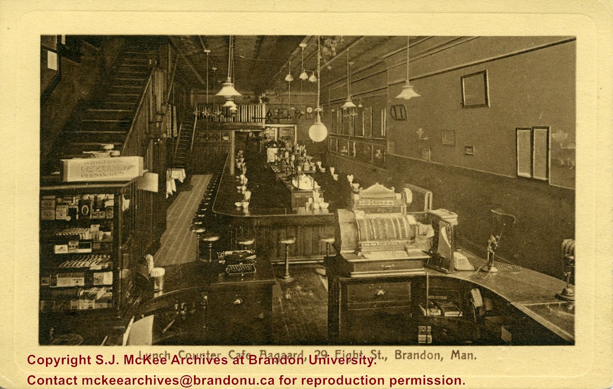
Postcard shows the interior of the lunch counter and cashier register at Cafe Aagaard located at 29-8th Street Brandon.
Notes
Writing on the front of the postcard reads: Lunch Counter Cafe Aagaard, 29 Eigth St., Brandon, Man. The back of the postcard reads: Cafe Aagaard, Largest, Oldest and Best in Brandon. The postcard is addressed to Mrs. K.L. McGregor, 157-4th St.
Name Access
Aagaard's
Cafe Aagaard
8th Street
Subject Access
restaurants
lunch counters
building interiors
store interiors
restaurant interiors
cafes
Brandon business buildings & facilities before 1940
Storage Location
RG 5 photograph storage drawer 2 (hanging photos)
Related Material
Lawrence Stuckey collection 1-2002.3.1E9
Images
Show Less

Mansfield's Western Shop - interior

http://archives.brandonu.ca/en/permalink/descriptions14329
Part Of
CKX fonds
Description Level
Item
GMD
graphic
Date Range
1967
Accession Number
11-2010
Part Of
CKX fonds
Creator
CKX
Description Level
Item
Series Number
M
Item Number
11-2010.M3b
Accession Number
11-2010
GMD
graphic
Date Range
1967
Material Details
Negative
History / Biographical
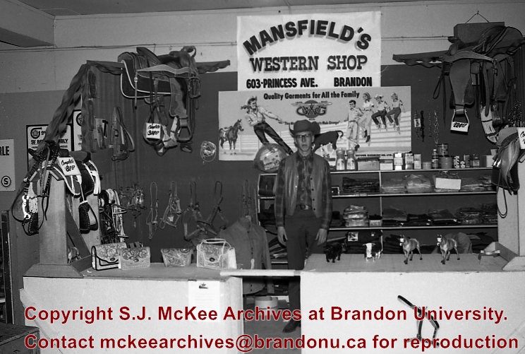
Mansfield's Western Shop was located on the corner of 6th Street and Princess Avenue at 603 Princess Avenue. The business appears to have been opened in 1966 by Ed and Jessie Mansfield. The shop was originally owened by Norman D. Moore and was called Moore's Western Shop. According to the Henderson's Brandon City Directory Mansfield's was relocated several times during its ownership. In 1967 Mansfields was reloacted to 737 11th Street, by 1973 had relocated again to 731 Princess Avenue and remained there until at least 1984. Mansfield's Western Shop had moved to it's final location at 1130 18th Street by 1988. Once Ed and Jessie retired the shop was taken over by their sons Les and Lyle Mansfield. Les and Lyle closed the store when they retired in 2015. Presently (2020) the H&Co Acadamy building stands where the original Mansfields Western Shop stood on 6th Street.
Custodial History
See Fonds level description for custodial history
Scope and Content
Image of the interior of Mansfield's Western Shop. The image is of a man standing behind the counter in dressed in a western style. The man could possibly be Ed Mansfield. There are various items displayed around the counter including: saddles, tack, figurines, clothing and hand bags. Above him is a sign that reads "Mansfield's Western Shop 603 Princess Ave. Brandon".
Notes
Hisotry/Bio information taken from Henderson's Directories. Description by Jillian Combs.
Subject Access
downtown
building interiors
businesses
Repro Restriction
Canadian Copyright Law may apply. Consult the archivist for access
Storage Location
CKX fonds - 2010 accessions
Arrangement
Original order maintained. Series arranged alphabetically by letter (A-Z) but negatives not alphabetical within each series.
Images
Show Less

Aerial view: Brandon University campus

http://archives.brandonu.ca/en/permalink/descriptions2576
Part Of
Brandon University Photograph Collection
Description Level
Item
GMD
graphic
Date Range
September 21, 1999
Part Of
Brandon University Photograph Collection
Description Level
Item
Series Number
9
Item Number
BUPC 9.36
GMD
graphic
Date Range
September 21, 1999
Physical Description
11" x 14" (colour)
History / Biographical
The photograph was taken for the Centennial of Brandon College/University.
Scope and Content
Aerial photograph taken looking southwest from approximately the northeast corner of Princess Avenue and 17th Street. The entire campus, as well as a number of residential streets are visible.
Notes
Negative is located with the photograph
Subject Access
campus buildings
aerial photographs
aerial photography
aerial views
cityscapes
Storage Range
Oversized drawer 4
Images
Show Less

Brandon College Building and Clark Hall

http://archives.brandonu.ca/en/permalink/descriptions2520
Part Of
Brandon University Photograph Collection
Description Level
Item
GMD
graphic
Date Range
c. 1911
Accession Number
41-1999
Part Of
Brandon University Photograph Collection
Description Level
Item
Series Number
9
Item Number
BUPC 9.42
Accession Number
41-1999
GMD
graphic
Date Range
c. 1911
Physical Description
11" x 14" (b/w)
Scope and Content
Photograph is looking west northwest from 18th Street and shows the Brandon College Building and Clark Hall.
Name Access
Clark Hall
Brandon College Building
Subject Access
campus buildings
Storage Range
Oversize drawer 5
Images
Show Less

Brandon College campus

http://archives.brandonu.ca/en/permalink/descriptions8292
Part Of
Brandon University Photograph Collection
Description Level
Item
GMD
graphic
Date Range
c. 1922
Accession Number
42-1999
Part Of
Brandon University Photograph Collection
Description Level
Item
Series Number
9
Item Number
BUPC 9.43
Accession Number
42-1999
GMD
graphic
Date Range
c. 1922
Physical Description
11" x 13.75" (b/w)
Physical Condition
The matting has a large tear and some stains. The photograph itself has a couple of small stains.
Scope and Content
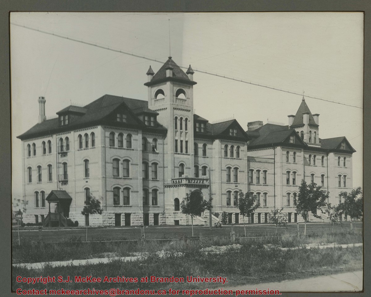
Photograph is looking southwest from the north end of the driveway and 18th Street and shows the Brandon College campus, including the front lawn, Clark Hall, the Brandon College Building and the Citizens' Science Building. Caption on the photograph reads: Brandon College: The Baptist College in Western Canada.
Notes
Duplicate is BUPC 9.33.
Name Access
Clark Hall
Brandon College Building
Citizens' Science Building
Subject Access
campus buildings
Storage Range
Oversize drawer 5
Related Material
BUPC 9.33
Images
Show Less

Barber George Irwin in shop

http://archives.brandonu.ca/en/permalink/descriptions13767
Part Of
Fred McGuinness collection
Description Level
Item
GMD
graphic
Date Range
[1909?]
Accession Number
20-2009
Part Of
Fred McGuinness collection
Description Level
Item
Series Number
McG 9
Item Number
20-2009.78
Accession Number
20-2009
GMD
graphic
Date Range
[1909?]
Physical Description
6" x 4" (b/w)
Physical Condition
Photograph is scratched
History / Biographical
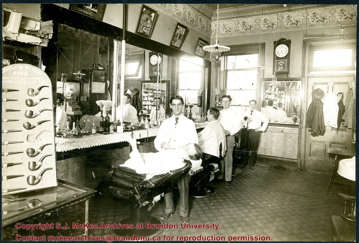
Gordon Irwin (1878 - 1968) was a long-time barber in Brandon, Manitoba. Irwin was born in Allenbank, Ontario. He married Elizabeth Jane Rollings (b. 04 Dec 1880, Napanee, ON; d. 24 Jul 1976, Brandon, MB) in Malton, Ontario, on January 11, 1905, and the couple moved to Brandon shortly thereafter. According to Henderson's Brandon City Directories, Gordon Irwin worked as a barber, for more than 49 years, in various establishments throughout the city. Notable shops include: the Imperial Hotel (1906), the CPR Barbers (1913-1923), Heise's (1929-1935), Kidds (1930-1941), and Robert Fowles (1949-1955). The Irwins celebrated their diamond anniversary in 1965, which was photographed and profiled in the Brandon Sun (14 Jan 1965, 8). According to his Brandon Sun obituary (19 April 1968, 12), Gordon Irwin passed away in Brandon on April 17, 1968, and was interned in the Rosewood Cemetery. The decorative ceiling and border are consistent with another photograph of a tobacconist's shop in the McGuinness collection (see 20-2009.1). According to Henderson's 1909 Brandon City Directory, Gordon Irwin - a barber - and tobacconist J.S. Rosby shared at storefront at 919 Rosser Avenue. This address is situated on the north side of Rosser Avenue, adjacent to a laneway. It is possible that the back of the shop overlooks the Grand Union Hotel on the corner of Pacific Avenue and 10th Street.
Scope and Content
Photograph shows the interior of a barber shop. Three barbers are posing by their chairs and two customers are receiving a shave. The barber in the centre has been identified as Gordon Irwin. A display for Rudolf's Patent Pipes is in the foreground. An ornate tin ceiling and elaborate border are visible in the photograph. Framed pictures hang above the mirror, including an advertisement for undertakers Vincent & Macpherson (1901-1906).
Notes
Writing on the back of the photograph reads: Dave Dick says centre barber is Gordon IRWIN, location may have been about 813 Rosser. May have been Kidd's Barber Shop. Harold Tackaberry confirms IRWIN. McGUINNESS.
Name Access
Gordon Irwin
J.S. Rosby
Rosser Avenue
Subject Access
store interiors
building interiors
barbers
barber shops
Storage Location
RG 5 photograph storage drawer 2 (hanging photos)
Related Material
McG 20-2009.1
Images
Show Less

18 records – page 1 of 1.