See fonds level description of the Alf Fowler collection for custodial history.
Scope and Content
Photo shows the the corner of 10th Street and Rosser Avenue, looking northwest. Visible businesses include: the Canadian Bank of Commerce; The Sun; Canadian Pacific; Brandon Brick Co.; T. Bronson; Fraser and Co.; and the John E. Smith Block.
Storage Range
RG 5 Western Manitoba Manuscript collection - photograph storage drawer
View is northwest from the 400 block of 18th Street to the corner of 23rd Street and Rosser Avenue. Photograph shows the Brandon College campus (Flora Cowan Hall under construction) and residential blocks.
View is south southwest from approximatley the east corner of 18th Street and Princess Avenue. Photograph shows the Brandon University campus, Kinsmen Stadium, Earl Oxford school and a number of residential blocks, particularly southwest of 18th Street.
Taken from an airplane, photograph is looking northwest from approximatley 15th Street and Louise Avenue. Shown are a number of residential blocks, the Brandon University campus, the railroad tracks and the Assiniboine River to approximatley 34th Street.
View is west northwest from aproximatley 15th Street and Louise Avenue to 34th Street. Photograph shows the Brandon University campus, part of Kinsmen Stadium, Fleming School, Coronoation Park, Valleyview Centennial School, Sacred Heart School ?, and residential blocks.
View is west northwest from aproximatley 16th Street and Louise Avenue to west of 34th Street. Photograph shows the Brandon University campus, part of Kinsmen Stadium, Coronoation Park, Valleyview Centennial School, part of the Assiniboine River and residential blocks.
View is west from 17th Street between Louise and Princess Avenues to approximalety 25th Street. Photograph shows the University campus, Fleming School, Coronation Park and residential blocks.
View is northeast from approximately the southwest corner of Victoria Avenue and 22nd Street to the Assiniboine River near 1st Street. Photograph shows the College campus, Kinsmen Stadium, residential blocks, downtown and the railway tracks.
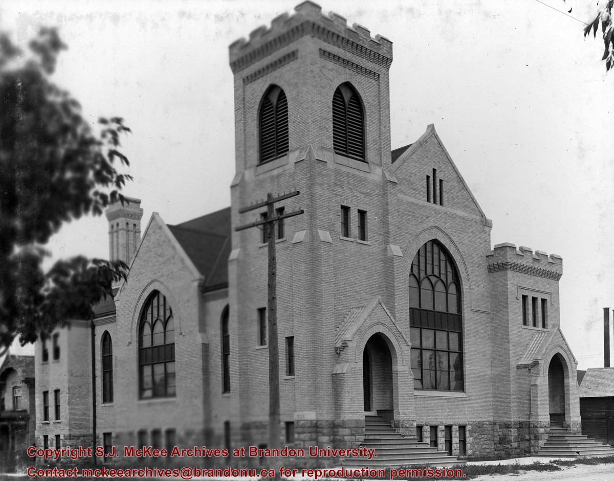
The First Baptist Church at the corner of 11th Street and Lorne Avenue was built in 1904 from the designs of W.A. Elliott. This was the Baptist congregation's second church; the first, a wood frame structure erected in 1885, stood on the southwest corner of 10th Street and Princess Avenue. A third church was built at 3881 Park Avenue, with the official dedication on October 16, 1994. At present (June 2007), the First Baptist Church in the photograph remains, but is unoccupied.
Custodial History
See fonds level description of the Alf Fowler collection for custodial history.
Scope and Content
Photo shows the First Baptist Church.
Notes
History/Bio information taken from the Assiniboine Historical Society's Brandon: An Architectural Walking Tour pamphlet (1982).
Storage Range
RG 5 Western Manitoba Manuscript collection - photograph storage drawer
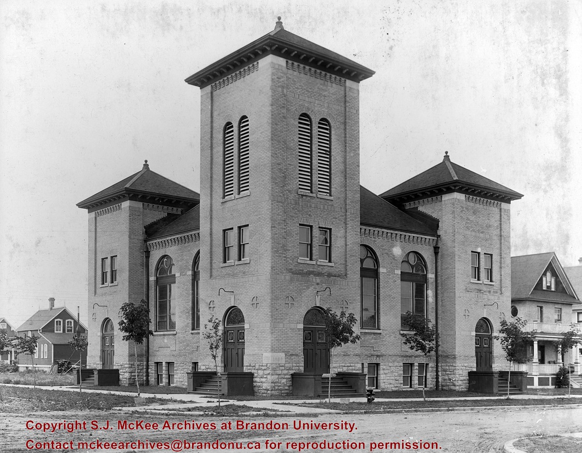
W.A. Elliot was commissioned by the Victoria Methodist congregation to design the church, which was built in 1909 and located at 1509 Victoria Avenue. Prior to that in 1896, Knox prsbyterian Church was built on the southeast corner of the same intersection of 15th Street and Victoria Avenue. When the United Church was organized during the 1920s, the two congregations joined to worship in Victoria Methodist, which took the name Knox United. In 1950, a new Knox United Church was built on the corner of Victoria Avnue and 18th Street and the present property sold to the Christian Reform Church.
Custodial History
See fonds level description of the Alf Fowler collection for custodial history.
Scope and Content
Photo shows the Victoria Methodist Church.
Notes
History/Bio information taken from the Assiboine Historical Society's Brandon: A Residential Walking Tour pamphlet (1993).
Storage Range
RG 5 Western Manitoba Manuscript collection - photograph storage drawer
View is southwest from approximately Princess Avenue and 17th Street. Photograph shows the Brandon University campus in fall, as well as the southwest portion of the city.
View is southwest from approximately 18th Street and Lorne Avenue. Photograph shows the Brandon University campus in winter, including: the Brandon University sign, the John R. Brodie Science Centre, the Citizens' Science Building and McMaster Hall.
View is northwest from approximatley the southeast corner of 18th Street and Louise Avenue. Photograph shows the University campus and residential blocks.
View is west from 17th Street between Louise and Princess Avenues. Photograph shows the Brandon University Campus, Fleming School and Coronation Park, as well as a number of residential blocks.
View is southwest from the 200 block of 17th Street. Photograph shows the Brandon University campus, Kinsmen Stadium, Fleming School and a number of residential blocks.
View is southwest from approximatley the corner of 17th Street and Princess Avenue to McDiarmid Drive. Photograph shows the Brandon University campus, Kinsmen Stadium, Fleming School, Coronation Park and residential blocks.
View is northwest from approximately the corner of 18th Street and Louise Avenue. Photograph shows the Brandon College campus after the completion of Flora Cowan Hall.
Notes
BUPC 2.1.24 is a smaller version of this photograph.
View is southwest from the sidewalk on the west side of 18th Street. Photograph shows the Brandon University sign, the front lawn, the Citizens' Science Building, McMaster Hall and the John R. Brodie Science Centre.


