The records were created by a member of the administrative staff of the winter fair.
Custodial History
The records were housed at the MWF, and the MEA until c1986 when they were transferred to the S.J. McKee Archives at Brandon University.
Scope and Content
The series includes two files that house correspondence dealing with the issue of complimentary tickets. As well, the series includes many examples of tickets, badges, and ribbons from the winter fairs of 1966-1973.
Notes
Part of RG2SF2. Inventory of the documents in the series is available in the printed finding aid.
Storage Location
RG 2 Provincial Exhibition of Manitoba Association fonds
RG2SF2 Manitoba Winter Fair
In 1973, the Board of Directors of the Provincial Exhibition of Manitoba along with various farm representatives around the area began to feel the need for another, this time purely agricultural, exhibition. The issue was raised in the form of a report written by Donn Mitchell, the chairman of the livestock committee. Because of the growth of both the winter and summer fairs, there was little time and room to properly show the livestock that farmers brought into Brandon. A fall show and sale was thought to be the best solution to the pressing need for both time and space.
After receiving support from the provincial government and the Manitoba Beef Growers Association, the Board decided to hold a fall exhibition. While the Board was wary that the show would succeed, the strong support from producers, government and agri-business virtually ensured success. The first AgEx was officially opened on 3 November 1975. Although the first year was not a financial success, the concept of an agricultural exhibition was, and AgEx continues to thrive in Brandon.
While no minutes are held in this collection for either the Board of Directors or committees, it is evident from the prize lists and programs that the following committee structure existed. There were several committees created by the Board of Directors of AgEx. By 1984 the committees included the AgEx Chairman, the Executive, Aberdeen Angus, Blonde d’Aquitaine, Charolais, Hereford, Holstein, Limousin, Maine Anjou, Salers, Simmental, Steers, Swine, and 4-H/Junior Activities. A Shorthorn committee was added by 1985, and by 1988 there was a Commercial Classic committee.
Custodial History
The sous-fonds was housed at the MEA until c1986 when it was transferred on a continuing basis to the S.J. McKee Archives located at Brandon University.
Scope and Content
The sous-fonds contains textual records and photographs pertaining to AgEx. The textual records include prize lists, programs, administrative files, original results, and news releases. The photographs include animal events and shows, dignitaries. entertainment, and various other events.
The sous-fonds has been divided into five series, including: (4) Administrative files; (5) Prize lists and programs; (6) News releases; (7) Original results; and (9) Photographs. In keeping with the numbering system used for the series in the other sous-fonds in RG 2 Provincial Exhibition of Manitoba Association, the series in RG2SF3 maintain the same numbering system, therefore there is no series 3.1, 3.2, 3.3, or 3.8.
Storage Location
RG 2 Provincial Exhibition of Manitoba Association fonds
RG2SF3 AgEx
The series consists of records that either did not fit, or could not easily be placed into one of the preceding three manuscript groups. The series had several creators, including the Board of Directors for both the summer and winter fairs, the combined Provincial Exhibition of Manitoba Board of Directors, and others. The records also include several documents, and financial records of the combined winter and summer fairs organization, known as the Provincial Exhibition of Manitoba Association. This Association began in the fall of 1969 with the amalgamation of the Manitoba Winter Fair and the Provincial Exhibition of Manitoba.
Custodial History
The sous-fonds was housed in the WAAA, the PEM, the MWFFSA and the MEA until c1986 when it was transferred to the S.J. McKee Archives at Brandon University.
Scope and Content
The sous-fonds consists of textual records and photographs that did not fit easily into one of the other manuscript groups. The textual records include financial, scrapbooks, shareholder’s lists and miscellaneous. There are several documents regarding the building of the Keystone Centre, as well as administrative papers dealing with the Provincial Exhibition of Manitoba Association. There are some minutes, and several financial records, as well as a brief administrative file. The photographs are diverse.
The sous-fonds has been divided into seven series, including: (1) Documents; (2) Minutes; (3) Financial records; (4) Administrative files; (9) Photographs; (10) Scrapbooks; and (11) Miscellaneous. In keeping with the numbering system used for the series in the other sous-fonds in RG 2 Provincial Exhibition of Manitoba Association, the series in RG2SF4 maintain the same numbering system, therefore there is no series 4.5, 4.6, 4.7, or 4.8.
Storage Location
RG 2 Provincial Exhibition of Manitoba Association fonds
RG2SF4 Miscellaneous
Introduction
Information on archaeological materials in this locale first came to the attention of Dr. Nicholson through Doug Jackson, a local artifact collector from Souris. Doug had observed archaeological materials that included bone, ceramics and lithic material that had been exposed by municipal road building activity, northwest of Lauder Manitoba
Environment
The Makotchi-Ded Dontipi locale is located among stabilized sand dunes in the Lauder Sandhills in Southwestern Manitoba, northwest of the village of Lauder. The area is a mosaic of medium grass prairie and copses of aspen poplar and aspen-oak, together with intermittent sedge grass marshes and small ponds. These wetlands are bordered with balsam poplar, water birch, willows and red osier dogwood.
The well-drained upland forest also contains saskatoon, chokecherry, wild current, hazelnut bushes and occasional wild plums. Lowland areas have nannyberries and high-bush cranberry. Wild strawberries grow in lightly shaded areas along trail margins and in open patches in aspen forest.
History of Excavations
The Makotchi-Ded Dontipi locale is a virtual "island" of forest and marshlands in a vast expanse of mixed grass prairie. This archaeologically and environmentally rich area was given the Dakota name Makotchi-Ded Dontipi, meaning "the place where we live".
Summation
Prior to European settlement, the area was a rich environment for hunter-gatherer people. Archaeological investigations from 1992 to 2002 have revealed numerous sites within the locale. Some of these sites have been extensively excavated while others have been identified or tested.
Seven sites that have been identified in this locale range in age from the historic through protohistoric periods and extend into the middle precontact period. The major sites are the initial Middle Missouri Duthie site, the late precontact Jackson, Bradshaw sites and the protohistoric Twin Fawns, Schuddemat and Hollow B sites. The multi-component Vera site includes historic Métis, late precontact Vickers Focus, and middle precontact Besant, Pelican Lake, McKean Complex and Oxbow occupations. Over 230 units were excavated as well as numerous test pits and several extensive surveys.
Scope and Content
Scope and Content
The Series has been divided into seven sub-series, including (1) Duthie site (2) Jackson site (3) Twin Fawns site (4) Vera site (5) Schuddemat site (6) Bradshaw site (7) Hollow B site.
The Duthie site is the first site identified in the Makotchi-Ded Dontipi locale. It was reported to Dr. Bev Nicholson by Doug Jackson, a local collector who had observed archaeological materials that had been exposed during the construction of Maple Hill Road northwest of Lauder. The site is named after the landowner, Randy Duthie.
The initial inspection of the exposed materials indicated that the eastern half of the site had been severely impacted by raising a road grade using an elevating grader. However, an undetermined amount of the site remained to the west, flanked by a low sand dune. Testing and preliminary excavations were conducted in 1992-93. In 1994 a field school added to the excavated sample. The undisturbed portion of the site, west of Maple Hill Road was situated at the base of a low sand dune and had an aspen and willow forest cover. The water table was approximately one meter below surface at the time of excavation. A rising water table has since prevented further excavations.
Two dates on bone collagen were obtained during excavations. These were 880+/-80 B.P. (Beta 62705) and 970+/-40 B.P. cal. 1030 A.D. (TO 13366). These dates are consistent with an Initial Middle Missouri cultural assignment. The site occupation is identified by the distinctive ceramics found there. Ceramics at the Duthie Site are tool impressed with incising and lip modeling with fabric impressions on most vessels. Jill Taylor analysed the ceramics from the site for a Specialist thesis, Brandon University (1994) and a Masters of Arts degree from the University of Saskatchewan. (Taylor 1995).
Analysis of residue from Duthie site pottery by Matthew Boyd recovered corn (Zea mays) phytoliths and bean (Phaseolus sp.) starch grains indicating consumption of these domesticates at the Duthie site. (Boyd 2006)
The occupation of this site indicates a migration of people from the south who were well acquainted with horticultural farming. These people had previously migrated to South Dakota following river valleys into the central plains from the eastern woodlands during late Hopewell times. It appears that they later migrated well to the north into southern Manitoba but there is no evidence that they remained there for more than a single year.
Boyd, M., C. Surette and B.A. Nicholson. 2006 Archaeobotanical Evidence of Prehistoric Maize (Zea mays) Consumption at the Northern Edge of the Great Plains. Journal of Archaeological Science 33: 1129-1140.
Taylor, J. 1994 An analysis of the ceramics recovered during 1992 and 1993 at the Precontact Duthie Site (DiMe-16). Specialist thesis, Brandon University.
Scope and Content
The Series has been divided into seven sub-series, including (1) Duthie site (2) Jackson site (3) Twin Fawns site (4) Vera site (5) Schuddemat site (6) Bradshaw site (7) Hollow B site.
Field journals have been scanned in multi-page PDF files.
History / Biographical
The Crepeele site was excavated in 2003 as Crepeele 3. Standard archaeological methods were used to excavate the units. Excavation units were initially numbered as units 10, 11, 12 & 13. These numbers have been changed on the catalogue to XU 110 – 113, due to duplication in 2005. Corresponding documents have been changed to reflect the amended excavation unit numbers, however the field journals may contain the initial numbers.
Scope and Content
Record of daily observations at the site including: excavation methods, items recovered, features, local environment and weather.
The high biodiversity and evidence of pre-Europeon contact prompted the decision to test the Crepeele locale. The survey was named in recognition of the Casselman family, the original landowners.
Archaeological testing began in the Crepeele locale in May 2003 on property now owned by the Crepeele family. The locale covers over 6 sections or approximately 3,800 acres of land in an area of stabilized sand dunes and wetlands covered with mixed forest and prairie grass. Given the terrain, the size of the crew and time constrains, an area of approximately 60 acres was chosen for the survey. The survey used the established archaeological methodology of walking the selected area and using a shovel test surveyed grid. The use of GIS technology to locate the exact test spot and record the information into a GIS database was a significant advance and was one of the advantages of the integration of multi-disciplinary techniques encouraged by the SCAPE project. Over one half of the test pits resulted in the recovery of cultural materials. The results of the Casselman survey indicated several areas for further examination including areas that became the Crepeele, Sarah and Graham sites.
Scope and Content
Sub sub series has been divided into five sub sub sub series including: (1) Summary information; (2) Field journals; (3) Site records; (4) Artifact catalogues; and (5) Photographs.
Field journals have been scanned in multi-page PDF files. Artifact catalogues are PDF files in spreadsheet format. Photographs are in jpeg format.
History / Biographical
The Crepeele site was identified from the results of the Casselman survey. The site is located within the Crepeele locale approximately 400 meters to the west of the Sarah site. The units were excavated by Crew Chief James Graham and the crew from the survey.
The Crepeele site was excavated in 2003 as Crepeele 3 with the units numbered as units 10, 11, 12 & 13. These numbers have been changed on the catalogue to XU 110 – 113, due to duplication in 2005. Corresponding documents have been changed but there may be some reference to the initial numbers in the field journals.
The artifacts recovered from these four excavations are faunal (animal bone), mainly bison, lithic materials (stone tools and flakes) and some ceramic (pottery). The artifact catalogue has over 600 records.
Scope and Content
Sub-sub-sub series contains: Summary information of field methology, number and co-ordinates of excavations, personnel and their staff position; Field journalsare daily records of recoveries, features and activities at the site; Site records include excavation level and unit summaries, feature sheets, profiles; sample records and maps; Artifact catalogues are lists and identifications of all artifacts recovered; Photographs are of excavation units, features, the landscape and personnel.
Site records have been scanned in multi-page PDF files.
History / Biographical
The Crepeele site was excavated in 2003 as Crepeele 3. Standard archaeological methods were used to excavate the units. Site records of excavation units XU 110 – 113 are in seperate pdf files.
Scope and Content
Site records of excavation units may include: level summaries, floor plans, feature sheets, wall profiles, unit summaries and any other additional information relating to the unit.
Field journals have been scanned in multi-page PDF files. Artifact catalogues are PDF files in spreadsheet format. Photographs are in jpeg format.
History / Biographical
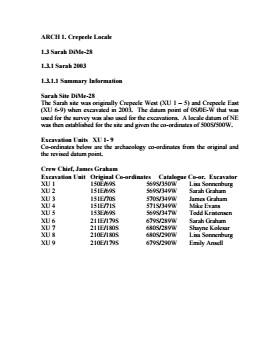
The Sarah site was initially chosen for excavation based on the results of the Casselman survey. The survey recovered significant amounts of faunal remains, some ceramics and lithics from the test pits. Excavations took place in 2003 at Crepeele West (Units 1-5) and Crepeele East (Units 6-9). The site was subsequently renamed the Sarah site DiMe-28.
Units 1 to 9 were excavated by supervisor James Graham and crew of Sarah Graham, Mike Evans, Todd Kristensen, Shayne Kolesar, Lisa Sonnenburg and Emily Ansell.
Scope and Content
Sub-sub-sub series contains: Summary information of field methology, number and co-ordinates of excavations, personnel and their staff position.
Field journals have been scanned in multi-page PDF files. Artifact catalogues are PDF files in spreadsheet format. Photographs are in jpeg format.
History / Biographical
Archaeological testing began in the Crepeele locale in May 2003 with a field crew of four members. James Graham supervised the crew and was assisted by Sarah Graham, Jollana Bishop, and Lisa Sonnenburg. Later additions to the testing team were Todd Kristensen, Michael Evans, and Emily Ansell.
The methodology for this survey used an arbitrary datum and a transit to establish a grid of 30 m intervals and a shovel test every 20 m. Materials were removed and screened to a minimum depth of 50 cm below surface. All recovered materials were bagged and removed to the lab for further analysis. All information including: test pit grid co-ordinates; UTM co-ordinates for each test pit; artifact presence; excavator; vegetation; aspect; paleosol; paleosol depth; and notes, were entered into a GIS database.
Approximately 600 shovel test pits were excavated and recorded in this fashion. Of the 600 shovel test pits, over 300 contained cultural materials. Based on the results of the Casselman survey several areas were designed for further testing and excavation. Crepeele West and Crepeele East were renamed the Sarah site DiMe-28) and Crepeele 3 which became the Crepeele site DiMe- 29.
Scope and Content
Sub-sub-sub series contains: Summary information of field methology, number and co-ordinates of excavations, personnel and their staff position; Field journalsare daily records of recoveries, features and activities at the site; Site records include excavation level and unit summaries, feature sheets, profiles; sample records and maps; Artifact catalogues are lists and identifications of all artifacts recovered; Photographs are of excavation units, features, the landscape and personnel.
Field journals have been scanned in multi-page PDF files. Artifact catalogues are PDF files in spreadsheet format. Photographs are in jpeg format.
History / Biographical
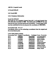
The Crepeele site was identified from the results of the Casselman survey and excavated in 2003. In 2004 the site was funded through the SCAPE project, directed by Bev Nicholson. The units were excavated by Crew Chief Tomasin Playford and crew.
Eight units were excavated in 2004, XU 1to XU 8
The artifacts recovered from these eight excavations are faunal (animal bone), mainly bison, lithic materials (stone tools and flakes) and some ceramic (pottery). The artifact catalogue has 1258 records.
Scope and Content
Sub-sub-sub series contains: Summary information of field methology, number and co-ordinates of excavations, personnel and their staff position; Field journalsare daily records of recoveries, features and activities at the site; Site records include excavation level and unit summaries, feature sheets, profiles; sample records and maps; Artifact catalogues are lists and identifications of all artifacts recovered; Photographs are of excavation units, features, the landscape and personnel.
Field journals have been scanned in multi-page PDF files. Artifact catalogues are PDF files in spreadsheet format. Photographs are in jpeg format.
History / Biographical
The Crepeele site was identified from the results of the Casselman survey and excavated in 2003. Further units 1 to 8 were excavated in 2004. Funding was through the SCAPE project, directed by Dr. Bev Nicholson. The site was excavated by Crew Chief Tomasin Playford and crew.
Scope and Content
Sub-sub-sub series contains: Summary information of field methology, number and co-ordinates of excavations, personnel and their staff position.
Field journals have been scanned in multi-page PDF files.
History / Biographical
In 2005 the Brandon University Field School was held at both the Crepeele and Graham sites in the Crepeele locale.
At the Crepeele site nine units were excavated (XU10-16 & 20, 21). Units 20 & 21 were referred to as Meadow in the notes but are considered part of the larger site based on recoveries.
Denise Ens instructed the school and James Graham was teaching assistant. Field journals were kept by both instructors.
Scope and Content
Record of daily observations at the site including: excavation methods, items recovered, features, local environment and weather.
Site records have been scanned in multi-page PDF files.
History / Biographical
The Crepeele site was identified from the results of the Casselman survey and excavated in 2003. In 2004 the site was funded through the SCAPE project, directed by Bev Nicholson. The units were excavated by Crew Chief Tomasin Playford and crew.
Eight units were excavated in 2004, XU 1 to XU 8. Each unit has a seperate pdf file.
Scope and Content
Site records of excavation units may include: level summaries, floor plans, feature sheets, wall profiles, unit summaries and any other additional information relating to the unit.
In 1988 four 1m2 units were excavated in this Block F. The forest cover is identical to that of Block E, with an open oak forest with a light understory of saskatoon, hazelnut, poison ivy and sarsaparilla.
Underneath the litter mat (Ah) is a shallow, 15-20 cm “A” horizon of dark grey/brown silty loam with a high representation of pebble size clasts. The glacial clays, encountered at 20 cm below surface, consist of a matrix of light tan sandy clays containing rounded pebble to cobble size rocks.
The recoveries from this block consisted of a few ceramics, including Vickers Focus rim sherds, four lithic tools and a number of small bison bone fragments. There was no discernible cultural stratigraphy in the four 1m2 units and the limited deposits of bone, ceramics and lithics were dispersed randomly throughout the 25 cm of cultural matrix. The lithic materials frequencies were similar to those in Block E with local cherts and KRF being the most abundant categories. A small amount of fire-cracked rock and a few large identifiable bison bones were recovered – all distributed randomly with little evidence for any pattern of clustering.
No RC dates.
Scope and Content
Sub-sub-sub series contains: Summary information of field methology, number and co-ordinates of excavations, personnel and their staff position; Field journals are daily records of recoveries, features and activities at the site; Site records include excavation level and unit summaries, feature sheets, profiles; sample records and maps; Artifact catalogues are lists and identifications of all artifacts recovered; Photographs are of excavation units, features, the landscape and personnel.
Field journals have been scanned in multi-page PDF files. Artifact catalogues are PDF files in spreadsheet format. Photographs are in jpeg format.
History / Biographical
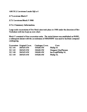
Large scale excavations of four block sites took place in 1988 under the direction of Bev Nicholson with Ian Kuijt as crew chief. Block F consisted of 4 excavation units.
Scope and Content
Sub-sub-sub series contains: Summary information of field methology, number and co-ordinates of excavations, personnel and their staff position.
In 1988 four units were excavated in Block G. The vegetation is similar to other areas in the locale with an open oak forest with a light understory of saskatoon, hazelnut, poison ivy and sarsaparilla.
Excavations recovered artifacts between 0 cm – 15 cm b.s. The cultural deposits are very shallow and it is quite possible that what appears to be a single occupation may in fact represent multiple occupation compressed deposits as a result of deflation or the lack of sedimentation in this raised area. This latter view is supported by the ceramics which appear to be a mixture of Blackduck and Vickers Focus wares.
The frequency and distribution of cultural material from block G contrasts with that of other sites in the locale. While the diagnostic materials are similar, the nature of the background debris and the associated lithic assemblage suggests that this area was utilized for a different set of activities.
Unlike Blocks E and H, there is very little in the way of ceramics, fire-cracked rock or bison bone, yet a significant amount of lithic debitage and six Plains/Prairie Side-notched projectile points were recovered. No unifaces or scrapers were recovered. This may be an area where activities such as manufacture and hafting of projectile points; hunting activities, butchering and refuse disposal took place.
No RC dates were taken.
Scope and Content
Sub-sub-sub series contains: Summary information of field methology, number and co-ordinates of excavations, personnel and their staff position; Field journals are daily records of recoveries, features and activities at the site; Site records include excavation level and unit summaries, feature sheets, profiles; sample records and maps; Artifact catalogues are lists and identifications of all artifacts recovered; Photographs are of excavation units, features, the landscape and personnel.
Field journals have been scanned in multi-page PDF files. Artifact catalogues are PDF files in spreadsheet format. Photographs are in jpeg format.
History / Biographical
Large scale excavations of four block sites took place in 1988 under the direction of Bev Nicholson with Ian Kuijt as crew chief. Block G consisted of 4 excavation units.
Scope and Content
Sub-sub-sub series contains: Summary information of field methology, number and co-ordinates of excavations, personnel and their staff position.
The vegetation in block H is similar to other areas in the locale with an open oak forest with a light understory of saskatoon, hazelnut, poison ivy and sarsaparilla.
The excavations of the eight 1m2 units in 1988 resulted in the recovery of over 650 ceramic fragments including 20 rim sherds from at least four vessels, a grooved maul, fire-cracked rock, lithic debitage and a reworked Avonlea projectile point. A large amount of bison bone, including a number of axial elements and a fragmented skull were also recovered.
Based on the 1988 recoveries at the site further excavations took place in 1991. Nine excavation units were opened next to the previous excavations. Another 250 ceramic sherds were recovered in 1991. Nine vessels have been identified based on rim sherds. Vickers Focus and Woodland vessels have been identified and two vessels similar to Scattered Village Complex were recovered.
The lithic material assemblage is intermediate between Blocks G and E with KRF being the most frequent material category followed by local cherts.
Two features, a hearth and a curvilinear arrangement of rock were recovered. The high numbers of ceramic fragments suggests a habitation area, rather than hunting or butchering behavior. However, the separation of occupations at the site is difficult to establish and there may be different uses of the site by successive occupations.
Radiocarbon dates from this block indicate two occupations separated in time by some 300 years. XU 181 – 405/110 BP and XU 184 – 780/110 BP.
Scope and Content
Sub-series has been divided into sub sub series including: Lovstrom Block H 1988 and Lovstrom Block H 1991.