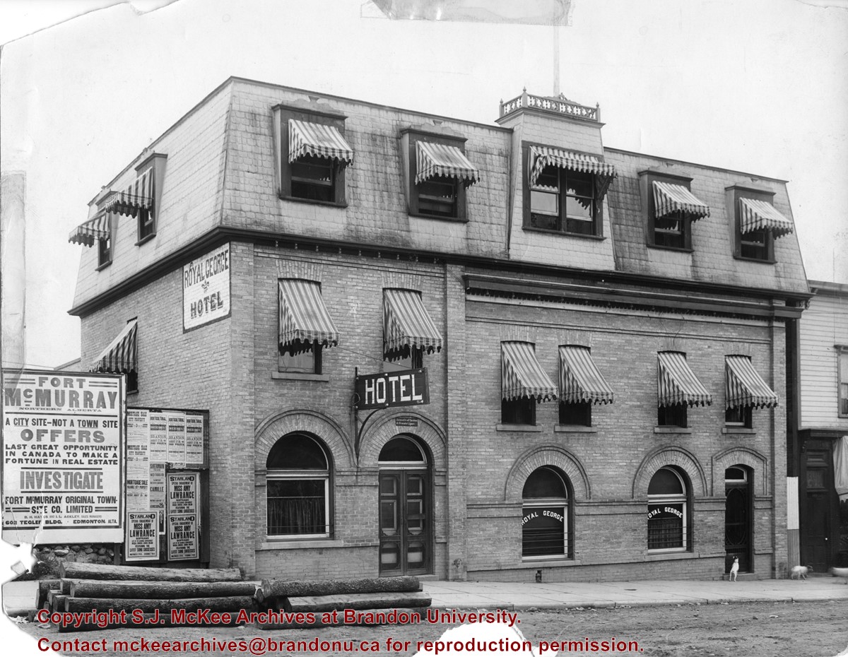
Photograph shows the exterior of the Royal George Hotel located at 142-6th Street, Brandon. Striped awnings cover the second and third storey windows of the hotel. Dogs roam the sidewalk in front of the hotel. Advertisements cover the fence adjacent to the hotel and include: Fort McMurray town site settlement; Mortgage sale for city property; Starland Theatre featuring Miss Amy Lawrence, Soprano; Sherman Theatre; 15th Annual Horticultural Exhibition
Notes
Date ascertained from 15th Annual Horticultural Exhibition advertisement posted on fence adjacent to hotel. Address obtained from Henderson's Brandon City Directory for 1913.
Photograph is stained and water damaged. A newspaper clipping about William (Billy) Muir is glued to the top left hand corner of the mat. The image is exfoliated in the right hand corner. The negative has been reverse printed.
History / Biographical
Coombs & Stewart opened the first general store in Brandon in 1881, which was located on 6th Street and Pacific Avenue. According to G.F. Barker (Brandon: A City, 1977, 291), William (Billy) Muir worked at the store until he opened his own grocery store in 1888.
Custodial History
Donated to Fred McGuinness by Allena Strath (nee Coombs).
Scope and Content
Photograph shows the Coombs & Stewart general store located on the corner of Pacific Avenue and 6th Street. A group of men pose in front of the wood-framed store.
Notes
Back of photograph reads: One of first stores in Brandon, Coombs...[?]
According to G.F. Barker (Brandon: A City, 1977, 291), William (Billy) Muir worked at Coombs & Stewart's on Pacific Avenue until he opened his own grocery store in 1888. The shop was located at 143-6th Street, Brandon, and was demolished for a parking lot in 1952.
Custodial History
Donated to Fred McGuinness by Allena Strath (nee Coombs).
Scope and Content
Photograph shows the "Wm. Muir General Grocer" building on 6th Street. Two men pose in the doorway of the store. The man on the left is likely William Muir. Barrels are lined on the boardwalk in front of the store. Apples and mason jars can be seen in the shop's windows.
Notes
Front of photograph reads: Sixth Street between Rosser - Princess. Back of photograph reads: Billy Muir's Store, 143 6th Street Brandon - 57 years in business in this location. An address label affixed to the back of the mat reads: Mrs. James Strath, Box 421, Souris, Man.
Corners of photograph mat are bent. Picture is cracked.
Scope and Content
Photograph shows an early view of Brandon's 6th Street in the 1880s. The Winter & O'Neail Groceries & Provisions and James Smart Hardware storefronts have been photographed. A street sign designating 6th Street can be seen below the Winter & O'Neail sign. A horse and cart is parked in front of the grocery store. A number of men wearing hats and jackets are standing along the boardwalk while posing for the picture. Lumber/timber saws are displayed in teh windows of the hardware store.
Notes
Front of photograph reads: 6th Street, Brandon, Manitoba, 1881-1882, Entrance [to Winter & O'Neail] corner of Rosser Ave & 6th Street.
Stuckey left a variety of materials in his collection in an unsorted state. Rather than allocate those materials to one of the existing sub-series, the McKee Archives chose to artificially create this sub-series, which has been designated "unsorted materials."
For history/bio information for Lawrence Stuckey see the collection level description of the Lawrence Stuckey collection.
Custodial History
For custodial history see the collection level description of the Lawrence Stuckey collection.
Scope and Content
Sub-series consists of photographic prints, photograph albums, postcards and negatives covering a variety of subjects including Brandon, ships, boats, threshermens' reunions, and rural Manitoba. Some of the prints correspond with negatives held in other sub-series in the Stuckey collection. If possible, the connection between the print and negative has been made at the item level. Some of the items are original and quite rare.
The dates given for many of the prints in this sub-series refer to the date the photograph was taken and not the date the print was made from the original negative.
Notes
Unidentifiable photographs not taken by Lawrence Stuckey and redundant prints were culled.
Repro Restriction
The McKee Archives is the copyright holder for the Stuckey materials.
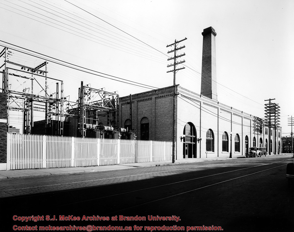
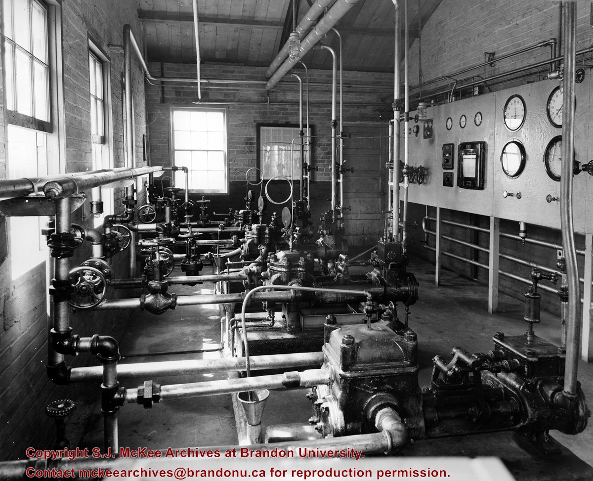
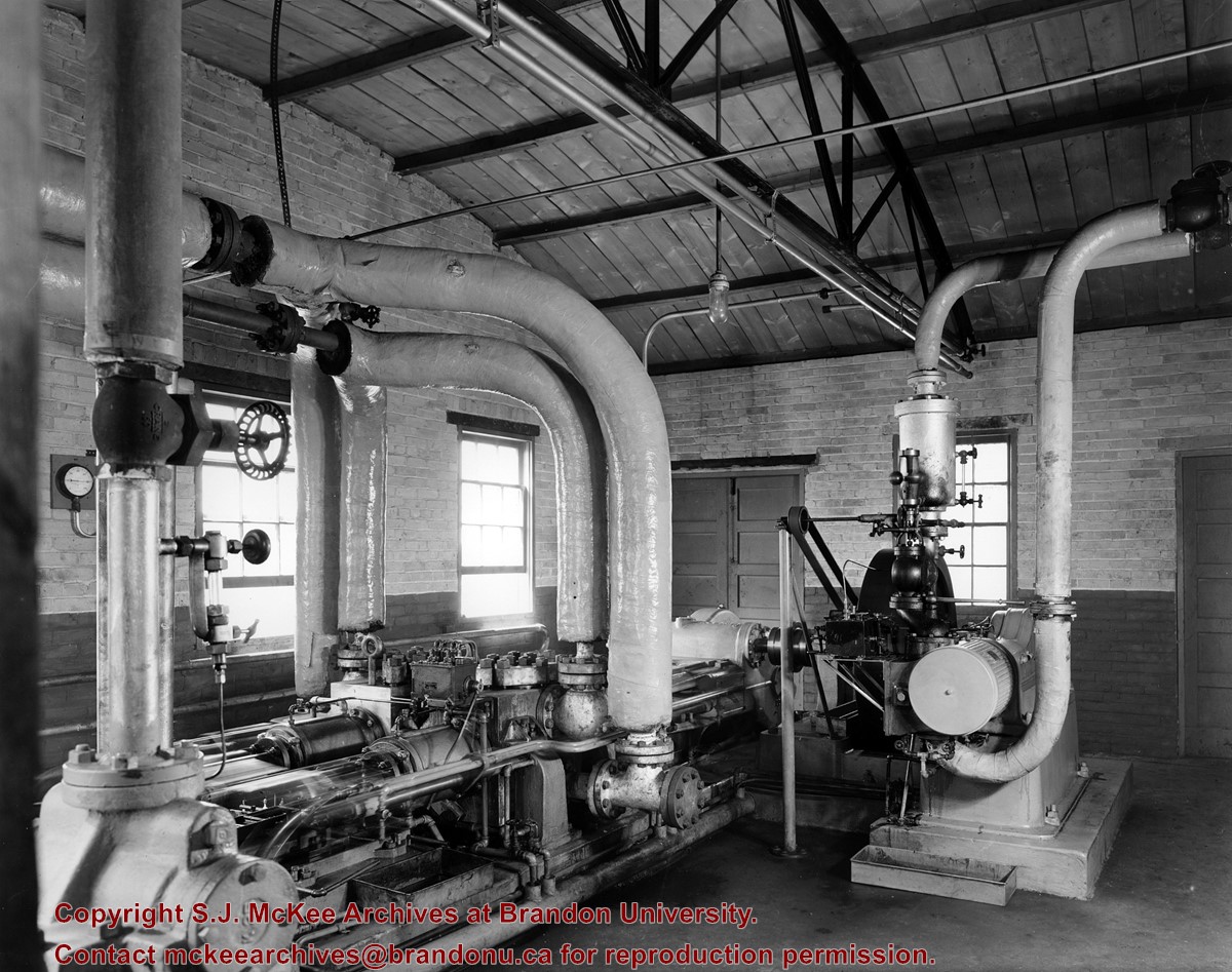
Photograph is looking southeast from the west side of 10th Street and shows the Manitoba Power Commission building and its transformers. The tracks for the Municipal Street Railway system are visible running north to south down 10th Street.
Repro Restriction
The McKee Archives is the copyright holder for the Stuckey materials.
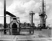
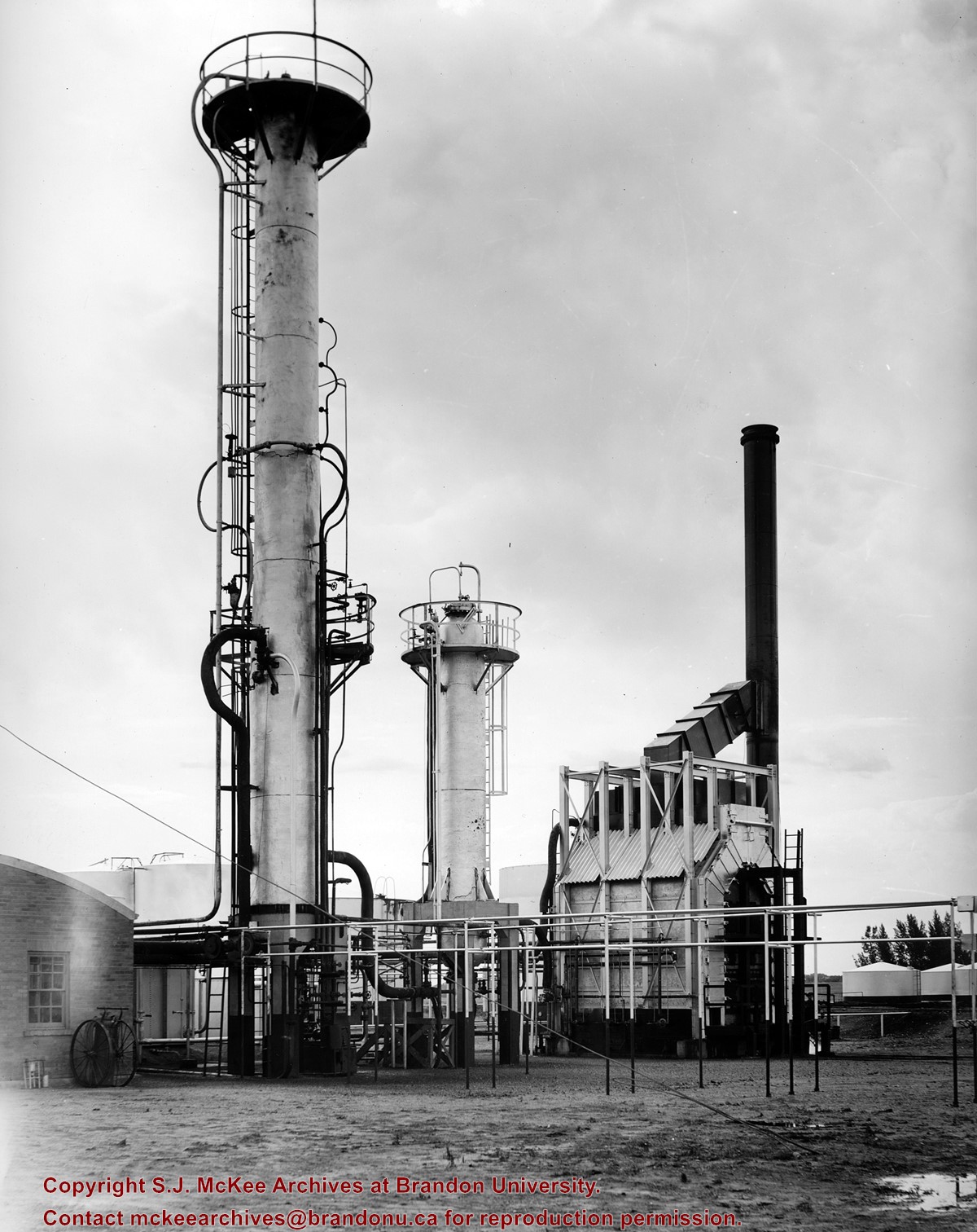
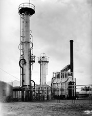
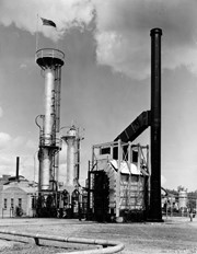
Central Refiners, which opened in 1936, was located at the southeast corner of 18th Street and Richmond Avenue. Initially owned and operated locally, the refinery was born from one of the old skimming plants that predated refining in Western Canada. That early plant skimmed the gasoline products from Turner Valley crude oil, using the collection material basically as tractor fuels to supply the farmers of the area.
The operation took a big step forward when it was allied with Anglo Canadian, a Calgary-based oil drilling exploration company, and turned into a proper refinery to refine the crude oil. That crude oil was hauled to Brandon by tank cars from the Anglo Canadian Turner Valley wells until about 1950 when the first trans-Canada popline was completed and a loop extended to the Brandon refinery.
In the early 1940s, shortly after it had been completed as a catalytic refinery, the plant went in to war production, producing the aviation gasolines used by the Commonwealth Air Trining Program in western Manitoba.
As Central REfiners and as Anglo Canadian Oils, the company was essentially a local one with businessmen and farmers of Brandon and western Manitoba owning big portions of the shares. In 1951, the British American Oil company purchased sharsin Anglo Canadian Oils and in 1964 BA became the principal owner.
Due to techonological and economic factors British American Oil Company decided to close the Brandon refinery, effective April 1, 1969.
Scope and Content
Photograph of Central Refiners.
Notes
History/Bio information taken from the article "Death knell for refinery" in the September 18, 1968 edition of the Brandon Sun.
Repro Restriction
The McKee Archives is the copyright holder for the Stuckey materials.
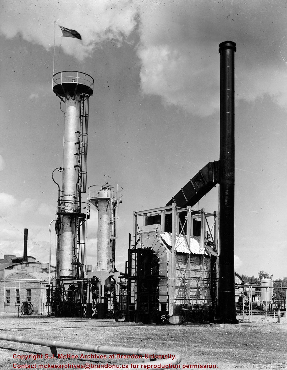
[The land on which city hall stood in this photo is now known as Princess Park. P.E. 01/06/09]
Custodial History
For custodial history see the collection level description of the Lawrence Stuckey collection.
Scope and Content
Princess Avenue, showing City Hall & CKX radio tower
Notes
[View is from 9th Street looking east. P.E.]
"Radio towers of CKX on city hall grounds were 150 feet tall; Studio and transmitter were on the east side of city hall." - Fred McGuinness collection (20-2009).
For custodial history see the collection level description of the Lawrence Stuckey collection.
Scope and Content
View of the southeast corner of Tenth Street and Princess Avenue, showing the Prince Edward Hotel (left) and an Imperial Oil Building (right).
Notes
The second floor of the Imperial Oil building became the Imperial Dance Garden in 1934. The small wooden post in a concrete foundation in the centre of the intersection was called a "Silent Policeman". You were supposed to keep it on your left while making a left turn. They took quite a beating.
[Information in "Notes" provided by the Fred McGuinness collection (20-2009).]


.jpg?width=1200&404=no-img.jpg&watermark=wmk)
.jpg?width=180&404=no-img.jpg)
.jpg?width=1200&404=no-img.jpg&watermark=wmk)
.jpg?width=180&404=no-img.jpg)
.jpg?width=1200&404=no-img.jpg&watermark=wmk)
.jpg?width=180&404=no-img.jpg)
.jpg%3fmaxheight%3d1000%26maxwidth%3d1000%26watermark%3dwmk&description=McLaren+School)
.jpg%3fmaxheight%3d1000%26maxwidth%3d1000%26watermark%3dwmk&description=McLaren+School)
.jpg%3fmaxheight%3d1000%26maxwidth%3d1000%26watermark%3dwmk&description=Prince+Edward+Hotel+-+Rotunda)