Margaret Menzies was born on July 30th, 1920, at a family farm located in Oakburn, Manitoba. She grew up on the family farm and attended school in both Oakburn and Shoal Lake. She married Donald Menzies on June 4th, 1941. Together they had four children. In 1959, the family moved to Brandon, Manitoba, where they lived for the rest of their lives.
Margaret Menzies was a longtime and active member of the International Toastmistress Club (ITC), and was also involved in the Consumers Association of Canada, Seniors for Seniors, as well as being a member of the Liberal Party of Canada and the Central United Church. Menzies did not graduate from high school in her early years, but managed to continue her education and receive a bachelor of arts degree from Brandon University at the age of 70.
Margaret Menzies passed away on June 9th, 2012.
Custodial History
Records in the collection were brought to the S.J McKee Archives on July 13, 2012, by Gerald Brown, on behalf of the family of Margaret Menzies.
Scope and Content
Collection contains of two scrapbooks created by Margaret Menzies. The scrapbooks contain various cards, itinerary's, and other documents associated with Menzies' membership in the International Toastmistress Club. The items in the scrapbooks date from the mid 1980's to the late 1990's.
Also included in the collection are four local history books. The first is a 100 year history of the town of Oakburn, Manitoba, from 1870 to 1970, published during celebrations of Manitoba's centenniary in 1970. Next is a book about the history of the town of Shoal Lake, Manitoba, which was published in 1959 on the 50th anniversary of the founding of the town of Shoal Lake in 1909. The last two books are the first and second volumes of Ripples on the Lake, which cover the history of the Shoal Lake municipality from 1884. The first volume covers the first 100 years of the history of the Shoal Lake region, being published in 1984. The second volume was published in 2007, covering the history of Shoal Lake since 1984, as well as including new information that was not published in the 1984 version of the book.
Finally, the collection contains one photograph of Margaret Menzies receiving her bachelor of arts degree from Peter Hordern, dean of arts of Brandon University.
Notes
Biographical information provided by obituary entry in the Brandon Sun, June 16, 2012. Description by Tyler Warren (October 2012).
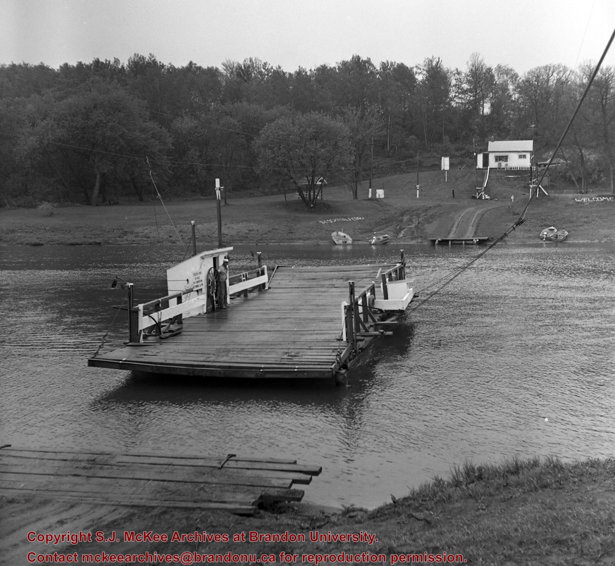
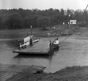
Situated in the R.M. of Whitehead on the Little Saskatchewan River, the 10 Mile Dam was a 14 kilometer transmission line that supplied the city of Brandon with power. The Brandon Electric Light Company built the dam in 1900 and it is considered Manitoba's first hydroelectic power generating station. The dam spanned approximately 80 meters and was constructed from timber and reinforced with clay and stone. The station was decommissioned in 1924.
Scope and Content
Photograph shows 10 Mile Dam, also known as the Brandon Dam or Minnedosa River Hydro Plant.
Notes
Writing on the back of the photograph reads: "10 mile dam". Biographical information obtained from Manitoba Historical Society.
Situated in the R.M. of Whitehead on the Little Saskatchewan River, the 10 Mile Dam was a 14 kilometer transmission line that supplied the city of Brandon with power. The Brandon Electric Light Company built the dam in 1900 and it is considered Manitoba's first hydroelectic power generating station. The dam spanned approximately 80 meters and was constructed from timber and reinforced with clay and stone. The station was decommissioned in 1924.
Alonzo Archibald Rowe (b. 1862, London, ON; d. 22 Oct 1951, Brandon). The Rowes were considered Brandon area pioneers. Alonzo’s father, Alonzo L. Rowe, came to Brandon with his family in 1881, where the family had a furniture and undertaker business on the west side of 10th Street between Rosser and Princess Avenues. In 1885, the family began farming west of Brandon and Alonzo Archibald served as a councilor and then a reeve in the R.M. of Whitehead. He returned to Brandon in 1907 and served with the Brandon Police Department until 1910, when he returned to farming, this time in Arrow River. A.A. Rowe returned to Brandon in 1915 to work as a Provincial Licenses Inspector, a position he held until 1938. (Source: Obituary, Brandon Daily Sun 22 Oct 1951)
Custodial History
Photograph was in possession of Mrs. Ruby Miles, who passed the image on to Fred McGuinness. McGuinness makes reference to Mrs. Miles and this photograph in his Sunbeams column (Source: F.A. Rosser, "Another interesting chat with a daughter of the plains," Brandon Sun 18 Aug 1981).
Scope and Content
Photograph shows four fishermen at 10 Mile Dam, also known as the Brandon Dam or Minnedosa River Hydro Plant. The fishermen in the photo are identified as George H. Rowe and his father A.A. Rowe, Dr. Wilfred Bigelow, and Al Collins.
Notes
Writing on the back of the photograph reads: at Brandon Dam, [right to left] son and father - George H. ROWE, Mr. A.A. ROWE, Dr. BIGELOW, Al COLLINS (dam?, 1906?, George born March 1897); Jerrett's Photo-Services, May 7 1938.
Postcard shows the 100 block of 10th Street facing north. The CPR train station can be seen at the end of 10th Street. The sign for the Rex Cafe is visible on the west side of 10th Street. On the east side of 10th Street, billboards for Campbell & Campbell furniture are visible as well as signs for Pianos and the Orpheum Theatre. Motorists and cyclists share the road. Street car tracks run the length of 10th Street.
Notes
Back of postcard reads: Morning reflection of Brandon's skyline on the Assiniboine River, photo by Sandy Black, printed in Brandno, Manitoba, Canada by Leech Printing Ltd.
Situated in the R.M. of Whitehead on the Little Saskatchewan River, the 10 Mile Dam was a 14 kilometer transmission line that supplied the city of Brandon with power. The Brandon Electric Light Company built the dam in 1900 and it is considered Manitoba's first hydroelectic power generating station. The dam spanned approximately 80 meters and was constructed from timber and reinforced with clay and stone. The station was decommissioned in 1924.
Scope and Content
Photograph shows 10 Mile Dam, also known as the Brandon Dam or Minnedosa River Hydro Plant. The dam's timber construction is quite evident in the picture.
Notes
Writing on the back of the photograph reads: McGuinness (Manitoba Hydro), on Little Saskatchewan.
For history/bio information see the collection level description of the Lawrence Stuckey collection.
Custodial History
For custodial history see the collection level description of the Lawrence Stuckey collection.
Scope and Content
Series consists of slides created from photographs taken by Lawrence Stuckey during his travels throughout Manitoba, other parts of Canada and the United States. Although Lawrence and his wife Mavis travelled for pleasure, their destinations were often chosen deliberately to enable Lawrence to explore and photograph specific landscapes, flora and fauna.


)
)
)