Trembley was a point along the Algoma Central Railway line that connected the Helen Mine to the Michipicoten Harbour. It is located southwest of Wawa, Ontario.
Scope and Content
Photograph shows railroad tracks. A line of ore cars stretch along one track. Writing on the side of one of the cars (#3017) reads: Algoma Central Railway Co.
Notes
Writing beneath the photograph in the album reads: Trembley - Ore Cars
The McKee Archives is the copyright holder of the Stuckey materials.
Storage Location
Lawrence Stuckey collection
Arrangement
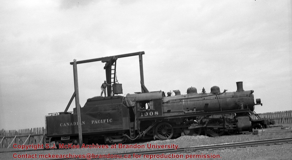
[Two original negatives C.P. in Manitoba volume 1. Mr. Stuckey put two negatives in same envelope. We have separated them and numbered them (10a) and (10b).
The McKee Archives is the copyright holder of the Stuckey materials.
Storage Location
Lawrence Stuckey collection
Arrangement
[Two original negatives C.P. in Manitoba volume 1. Mr. Stuckey put two negatives in same envelope. We have separated them and numbered them (10a) and (10b).
Mr. Stuckey's notes: Pub: Mainline Modeller 11/88.
Custodial History
For custodial history see the collection level description of the Lawrence Stuckey collection.
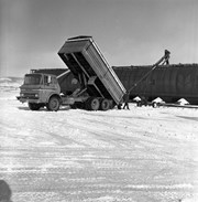
Scope and Content
Image of loading producer cars on CPR, Minnedosa, Manitoba. Image was taken along the CPR Minnedosa & Bredenbury subdivision (ex. Manitoba & N.W. Railway).
Mr. Stuckey's notes: Pub: Mainline Modeller 11/88.
Custodial History
For custodial history see the collection level description of the Lawrence Stuckey collection.
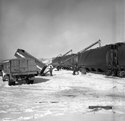
Scope and Content
Image of loading producer cars on CPR, Minnedosa, Manitoba. Image was taken along the CPR Minnedosa & Bredenbury subdivision (ex. Manitoba & N.W. Railway).
For custodial history see the collection level description of the Lawrence Stuckey collection.
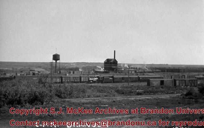
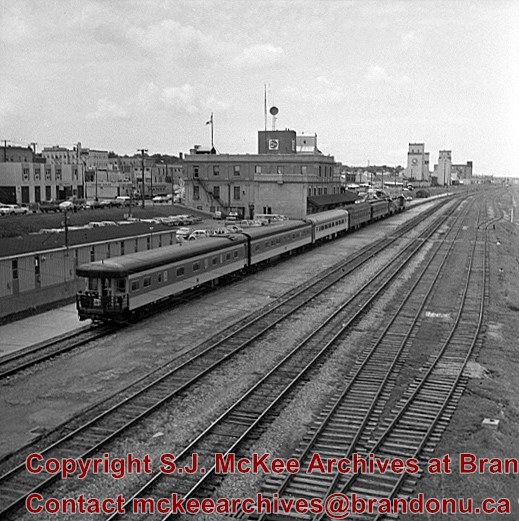
Scope and Content
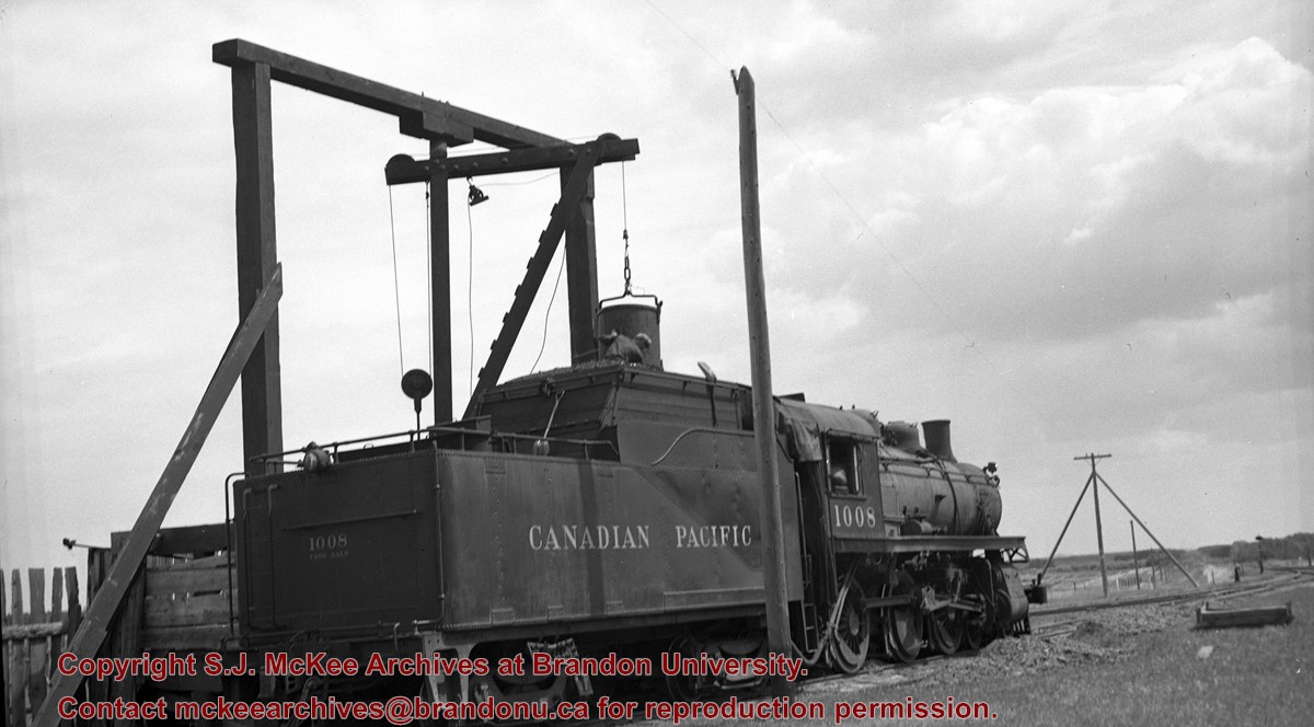
CPR No. 3, the westbound "Dominion", with engine 2829 under 1st Street Bridge
Notes
View includes former Empire Brewery, [then] in use by Bell Bottling Co.; Safe crossing over the CPR eliminated the need for a flagman. "Telltails" warn switchmen riding on top of railcars of low overhead clearance. Old Empire Brewery was (late 1950's) a feed mill, making grain feeds for livestock.
The Towerman controlled the crossing gates, [as well as] switches and signals for all routes into and out of the station and freight yards. [Mr. Stuckey's] grandfather, Samuel Gilmour, operated the previous tower for many years (which only operated the crossing gates), and continued to operate the new tower for several years after it was built (ca. 1929). This tower was made obsolete with the installation of Centralized Traffic Control in 1965.
Custodial History
For custodial history see the collection level description of the Lawrence Stuckey collection.
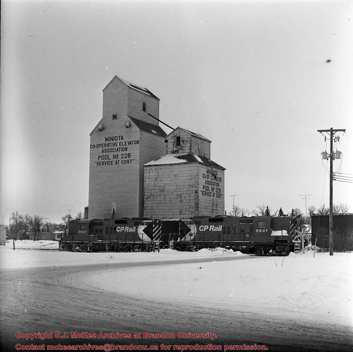
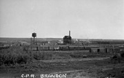
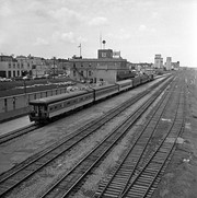
Scope and Content
Canadian Pacific Railway's18th Street crossing & signal tower.
Notes
Photo taken just before construction started on overpass
For a better picture of this tower see photo No. 53 (engine 2911) in CPR steam trains file
The McKee Archives is the copyright holder for the Stuckey materials.
Location Copy
1-2002.3.9.163
Storage Location
Lawrence Stuckey collection
Arrangement
[Mr. Stuckey numbered two envelopes P20. We have kept the same number but designated the first envelope P20(1) and the contents of the second envelope P20(2) and P20(3).]
Field journals have been scanned in multi-page PDF files. Artifact catalogues are PDF files in spreadsheet format. Photographs are in jpeg format.
History / Biographical
Archaeological testing began in the Crepeele locale in May 2003 with a field crew of four members. James Graham supervised the crew and was assisted by Sarah Graham, Jollana Bishop, and Lisa Sonnenburg. Later additions to the testing team were Todd Kristensen, Michael Evans, and Emily Ansell.
The methodology for this survey used an arbitrary datum and a transit to establish a grid of 30 m intervals and a shovel test every 20 m. Materials were removed and screened to a minimum depth of 50 cm below surface. All recovered materials were bagged and removed to the lab for further analysis. All information including: test pit grid co-ordinates; UTM co-ordinates for each test pit; artifact presence; excavator; vegetation; aspect; paleosol; paleosol depth; and notes, were entered into a GIS database.
Approximately 600 shovel test pits were excavated and recorded in this fashion. Of the 600 shovel test pits, over 300 contained cultural materials. Based on the results of the Casselman survey several areas were designed for further testing and excavation. Crepeele West and Crepeele East were renamed the Sarah site DiMe-28) and Crepeele 3 which became the Crepeele site DiMe- 29.
Scope and Content
Sub-sub-sub series contains: Summary information of field methology, number and co-ordinates of excavations, personnel and their staff position; Field journalsare daily records of recoveries, features and activities at the site; Site records include excavation level and unit summaries, feature sheets, profiles; sample records and maps; Artifact catalogues are lists and identifications of all artifacts recovered; Photographs are of excavation units, features, the landscape and personnel.
Block C was situated in sparse oak forest with an understory of saskatoon, hazelnut and a thick ground cover of poison ivy and sarsaparilla. The block measured 3m and 3m and contained nine excavation units. All units were excavated to 35cm below surface. The soil horizons were much like the other blocks, except for a rusty brown stain in the first level, giving the upper black loam a mottled appearance. The brown patches were clay mixed with loam and were harder than the surrounding matrix. No definitive interpretation of these phenomena was attempted but this effect may be the result of natural brush or forest fires. Under the 5cm so d/humus (Ah) layer, the loam horizon extended approximately 5cm – 25 cm below surface, and averaged 20 cm thick. Bone was concentrated within this horizon between 10 cm – 20 cm below surface.
Block C was notable for its concentrations of articulated bison bone. Most noteworthy was an articulated unit composed of lumbar vertebrae, pelvis, and sacrum. Several thoracic vertebra/proximal rib end concentrations were also recovered. There were more vertebrae and rib sections recovered in the units in proportion to other bones. A few sherds, some debitage and a single Prairie Side-Notched point fragment were among the recoveries. Based on the quantity of bone, the density of the bone layer, and the articulated butchering units the area has been interpreted as a bone midden.
Faunal material was analysed by Jessica MacKenzie for her Honours Thesis: "A reconstruction of butchering processes in Block C from the Lovstrom site DjLx-1 in Southwestern Manitoba."
Radiocarbon date: 850/115BP XU 79.
Scope and Content
Sub-sub-sub series contains: Summary information of field methology, number and co-ordinates of excavations, personnel and their staff position; Field journals are daily records of recoveries, features and activities at the site; Site records include excavation level and unit summaries, feature sheets, profiles; sample records and maps; Artifact catalogues are lists and identifications of all artifacts recovered; Photographs are of excavation units, features, the landscape and personnel.
Block D was wooded with oak and an understory of saskatoon and hazelnut with a thick ground cover of poison ivy and sarsaparilla. Root and rodent disturbance was extensive.
Based on the recoveries from Test Unit 22 during the survey, further excavations were carried out. Two units 87 and 93 were excavated in 1987. A further four units were excavated in 1988. There appears to be a pre contact occupation and a protohistoric feature within the block.
Diagnostic lithics included a chert Plains Side-notch projectile point, and a large Woodland side-notched point. The lithic materials from Block D are primarily local cherts followed in abundance by Knife River Flint and Tongue River Silicified Sediment – both of which are exotics imported from the southwest. Faunal remains were primarily bison.
Thin-walled obliterated fabric impressed pottery with grit temper was recovered in all units. Diagnostic ceramics included two rims, one with a fabric impressed exterior and the lip notched with dowel impressions, and a second thick walled rim was fabric impressed to the lip. The ceramic wares appear to be essentially a Woodland complex with overtones of Plains influence.
RC date: 230/90 BP.
Scope and Content
Sub-series has been divided into sub sub series including: Lovstrom Block D 1987 and Lovstrom Block D 1988.
This site is situated in a naturally sheltered area with a low rise to the east and south partly encircling a flat area open to the west. Present natural vegetation is an open oak forest with a light understory of saskatoon, hazelnut, poison ivy and sarsaparilla. It is situated on the till plain at the upper end of a ravine leading to Jock’s Creek.
Two test units six meters apart were excavated in 1987 and produced cultural materials which warranted a block excavation, so seven contiguous 1m2 units were then opened. These units proved to be very productive of cultural remains. Subsequent excavations in 1988 increased the number of excavated units to 21. In 1991 a further eight units were excavated for a total of 29 excavations and two test units. Excavations went deeper in this block than in Blocks C or B. Remains from the block included bison bone, bone tools, fire-cracked rock, ceramics, lithics including tools and debitage and a hearth. Another occupation was recovered in 1991 containing a hearth and living floor.
Radiocarbon samples have produced two distinct sets of radiocarbon dates from 1987 and 1988 excavations. There appears to be two or possibly three cultural horizons definable within this block.
An upper cultural horizon, located between 14-21 cm below surface, contains large bison bone and fire-cracked rock dating to 465/100B.P from XU 128.
A lower horizon in the 20-25 cm level contained FCR, bison bone and lithic scatter that was dated to 675/70 B.P. from XU 122 and 715/110 from XU 114.
Scope and Content
Sub-series has been divided into sub sub series including: Lovstrom Block E 1987, Lovstrom Block E 1988 and Lovstrom Block E 1991.
In 1988 four 1m2 units were excavated in this Block F. The forest cover is identical to that of Block E, with an open oak forest with a light understory of saskatoon, hazelnut, poison ivy and sarsaparilla.
Underneath the litter mat (Ah) is a shallow, 15-20 cm “A” horizon of dark grey/brown silty loam with a high representation of pebble size clasts. The glacial clays, encountered at 20 cm below surface, consist of a matrix of light tan sandy clays containing rounded pebble to cobble size rocks.
The recoveries from this block consisted of a few ceramics, including Vickers Focus rim sherds, four lithic tools and a number of small bison bone fragments. There was no discernible cultural stratigraphy in the four 1m2 units and the limited deposits of bone, ceramics and lithics were dispersed randomly throughout the 25 cm of cultural matrix. The lithic materials frequencies were similar to those in Block E with local cherts and KRF being the most abundant categories. A small amount of fire-cracked rock and a few large identifiable bison bones were recovered – all distributed randomly with little evidence for any pattern of clustering.
No RC dates.
Scope and Content
Sub-sub-sub series contains: Summary information of field methology, number and co-ordinates of excavations, personnel and their staff position; Field journals are daily records of recoveries, features and activities at the site; Site records include excavation level and unit summaries, feature sheets, profiles; sample records and maps; Artifact catalogues are lists and identifications of all artifacts recovered; Photographs are of excavation units, features, the landscape and personnel.


.jpg?width=1200&404=no-img.jpg&watermark=wmk)
.jpg?width=180&404=no-img.jpg)
.jpg%3fmaxheight%3d1000%26maxwidth%3d1000%26watermark%3dwmk&description=CPR+18th+Street+crossing+%26+signal+tower)