Skip header and navigation

Revise Search

20 records – page 1 of 1.

Album - Algoma Central and Hudson Bay Line

http://archives.brandonu.ca/en/permalink/descriptions14222
Part Of
Fred McGuinness collection
Description Level
Item
GMD
graphic
Date Range
[1900s]
Accession Number
1-2015
Part Of
Fred McGuinness collection
Description Level
Item
Series Number
McG 9
Item Number
1-2015.277.A14
Accession Number
1-2015
GMD
graphic
Date Range
[1900s]
Physical Description
4" x 2.5" (b/w)
Material Details
mounted in album
Physical Condition
Photo is warped
History / Biographical
In 1901, American entrepreneur Francis Hector Clergue (1856-1939) obtained the charter for the Ontario, Hudson Bay and Western Railway. Following his purchase, he reincoporated the Algoma Central Railway to the Algoma Central and Hudson's Bay Railway. (Source: Sault St. Mairie Public Library, "Transportation - Algoma Central Railway," Sault History Online, 2008)
Scope and Content
Photograph shows railroad tracks cutting through the Canadian Shield.
Notes
Writing beneath the photograph in the album reads: Algoma Central & Hundson Bay Ry.
Name Access
Algoma Central Railway Co.
Subject Access
Railroad Transportation
railways
mines
railroads
Storage Location
1-2015 McG 1.4 Box 1 (in stacks, top shelf)
Images
Show Less

Album - Lake Talbot Trestle

http://archives.brandonu.ca/en/permalink/descriptions14223
Part Of
Fred McGuinness collection
Description Level
Item
GMD
graphic
Date Range
[1900s]
Accession Number
1-2015
Part Of
Fred McGuinness collection
Description Level
Item
Series Number
McG 9
Item Number
1-2015.277.A15
Accession Number
1-2015
GMD
graphic
Date Range
[1900s]
Physical Description
4" x 2.5" (b/w)
Material Details
mounted in album
Physical Condition
Photo is warped
History / Biographical
The Lake Talbot tresle was a point along the Algoma Central Railway line that connected the Helen Mine to the Michipicoten Harbour. It is located north of Wawa and southwest of the Helen Mine.
Scope and Content
Photograph shows several men walking a railway line. Before them is a tresle bridge.
Notes
Writing beneath the photograph in the album reads: Lake Talbott Tresle [sic.]
Subject Access
Railroad Transportation
railways
mines
railroads
Storage Location
1-2015 McG 1.4 Box 1 (in stacks, top shelf)
Images
Show Less

Mulgrave, N.S. train station postcard

http://archives.brandonu.ca/en/permalink/descriptions13938
Part Of
Fred McGuinness collection
Description Level
Item
GMD
graphic
Date Range
1940s
Accession Number
1-2015
Part Of
Fred McGuinness collection
Creator
Photograph by: Fad Foto
Description Level
Item
Series Number
McG 9
Item Number
1-2015.10
Accession Number
1-2015
GMD
graphic
Date Range
1940s
Physical Description
5.5" x 3.5" (b/w)
Material Details
postcard
Scope and Content
Photograph shows the train station at the port of Mulgrave, Nova Scotia. Possibly the site where the HMCS Alachasse was docked when Fred McGuinness was a telegraphers in the Canadian Navy.
Notes
Writing on the back of the postcard reads: AZO post card
Name Access
Mulgrave, Nova Scotia
Subject Access
train stations
railways
Storage Location
RG 5 photograph storage drawer 2 (hanging photos)
Arrangement
Loose photos in funny trunk
Images
Show Less

Building fire near rail yard

http://archives.brandonu.ca/en/permalink/descriptions14127
Part Of
Fred McGuinness collection
Description Level
Item
GMD
graphic
Date Range
[1960-1965]
Accession Number
1-2015
Part Of
Fred McGuinness collection
Description Level
Item
Series Number
McG 9
Item Number
1-2015.196
Accession Number
1-2015
GMD
graphic
Date Range
[1960-1965]
Physical Description
3" x 3" (b/w)
Scope and Content
Photograph shows a dark cloud of smoke emerging from a building or warehouse near a train yard.
Subject Access
fires
trains
railways
Storage Location
RG 5 photograph storage drawer 2 (hanging photos)
Arrangement
BR #3 Family photos
Images
Show Less

Building fire near rail yard

http://archives.brandonu.ca/en/permalink/descriptions14128
Part Of
Fred McGuinness collection
Description Level
Item
GMD
graphic
Date Range
[1960-1965]
Accession Number
1-2015
Part Of
Fred McGuinness collection
Description Level
Item
Series Number
McG 9
Item Number
1-2015.197
Accession Number
1-2015
GMD
graphic
Date Range
[1960-1965]
Physical Description
3" x 3" (b/w)
Scope and Content
Photograph shows a dark cloud of smoke emerging from a building or warehouse near a train yard.
Subject Access
fires
trains
railways
Storage Location
RG 5 photograph storage drawer 2 (hanging photos)
Arrangement
BR #3 Family photos
Images
Show Less

Album - station at Brient

http://archives.brandonu.ca/en/permalink/descriptions14217
Part Of
Fred McGuinness collection
Description Level
Item
GMD
graphic
Date Range
[1900s]
Accession Number
1-2015
Part Of
Fred McGuinness collection
Description Level
Item
Series Number
McG 9
Item Number
1-2015.277.A9
Accession Number
1-2015
GMD
graphic
Date Range
[1900s]
Physical Description
4" x 2.5" (b/w)
Material Details
mounted in album
Physical Condition
Photo is warped
History / Biographical
Brient was a point along the Algoma Central Railway line that connected the Helen Mine to the Michipicoten Harbour. It is located southwest of Wawa, Ontario.
Scope and Content
Photograph shows several men standing on railway tracks before a wood-framed train station in the winter. A sign attached to the station reads: British American Express Co. The man in the foreground appears to have a mailbag over on his back and several newspapers tucked beneath his arm.
Notes
Writing beneath the photograph in the album reads: station at Brient
Name Access
Brient, Ontario
Subject Access
railways
train stations
Transportation
winter
Storage Location
1-2015 McG 1.4 Box 1 (in stacks, top shelf)
Images
Show Less

Album - Trembley iron ore cars

http://archives.brandonu.ca/en/permalink/descriptions14221
Part Of
Fred McGuinness collection
Description Level
Item
GMD
graphic
Date Range
[1900s]
Accession Number
1-2015
Part Of
Fred McGuinness collection
Description Level
Item
Series Number
McG 9
Item Number
1-2015.277.A13
Accession Number
1-2015
GMD
graphic
Date Range
[1900s]
Physical Description
4" x 2.5" (b/w)
Material Details
mounted in album
Physical Condition
Photo is warped
History / Biographical
Trembley was a point along the Algoma Central Railway line that connected the Helen Mine to the Michipicoten Harbour. It is located southwest of Wawa, Ontario.
Scope and Content
Photograph shows railroad tracks. A line of ore cars stretch along one track. Writing on the side of one of the cars (#3017) reads: Algoma Central Railway Co.
Notes
Writing beneath the photograph in the album reads: Trembley - Ore Cars
Name Access
Algoma Central Railway Co.
Subject Access
Railroad Transportation
railways
mines
Storage Location
1-2015 McG 1.4 Box 1 (in stacks, top shelf)
Images
Show Less

William Muir General Grocer building

http://archives.brandonu.ca/en/permalink/descriptions13757
Part Of
Fred McGuinness collection
Description Level
Item
GMD
graphic
Date Range
post-1888
Accession Number
20-2009
Part Of
Fred McGuinness collection
Description Level
Item
Series Number
McG 9
Item Number
20-2009.68
Accession Number
20-2009
GMD
graphic
Date Range
post-1888
Physical Description
4.5" x 7.5" (b/w)
Material Details
on matting
Physical Condition
Matting is bent and has a thumbtack hole.
History / Biographical
According to G.F. Barker (Brandon: A City, 1977, 291), William (Billy) Muir worked at Coombs & Stewart's on Pacific Avenue until he opened his own grocery store in 1888. The shop was located at 143-6th Street, Brandon, and was demolished for a parking lot in 1952.
Custodial History
Donated to Fred McGuinness by Allena Strath (nee Coombs).
Scope and Content
Photograph shows the "Wm. Muir General Grocer" building on 6th Street. Two men pose in the doorway of the store. The man on the left is likely William Muir. Barrels are lined on the boardwalk in front of the store. Apples and mason jars can be seen in the shop's windows.
Notes
Front of photograph reads: Sixth Street between Rosser - Princess. Back of photograph reads: Billy Muir's Store, 143 6th Street Brandon - 57 years in business in this location. An address label affixed to the back of the mat reads: Mrs. James Strath, Box 421, Souris, Man.
Name Access
Coombs & Stewart
Pacific Avenue
6th Street
Wm. Muir General Grocer
Subject Access
Pioneers
general stores
building exteriors
store exteriors
grocery stores
Brandon business buildings & facilities before 1940
Storage Location
RG 5 photograph storage drawer 2 (hanging photos)
Related Material
Lawrence Stuckey collection 1-2002.3.1E18
Images
Show Less

Education Building

http://archives.brandonu.ca/en/permalink/descriptions679
Part Of
Education building
Description Level
Item
GMD
graphic
Date Range
c. 1967
Part Of
Education building
Description Level
Item
Series Number
2.7
Item Number
2.7.1
GMD
graphic
Date Range
c. 1967
Physical Description
3.5" x 5.5" (colour)
Scope and Content
Postcard of the Education Building. Shows the east side of the building and the main entrance.
Images
Show Less

Education Building

http://archives.brandonu.ca/en/permalink/descriptions682
Part Of
Education building
Description Level
Item
GMD
graphic
Date Range
c. 1967
Part Of
Education building
Description Level
Item
Series Number
2.7
Item Number
2.7.2
GMD
graphic
Date Range
c. 1967
Physical Description
4.75" x 3.5" (b/w)
Scope and Content
Photograph is looking northwest from the front lawn and shows parked cars and the Education Building, particularly the south side of the building.
Images
Show Less

Education Building

http://archives.brandonu.ca/en/permalink/descriptions865
Part Of
Education building
Description Level
Item
GMD
graphic
Date Range
c. early 1970s
Part Of
Education building
Description Level
Item
Series Number
2.7
Item Number
2.7.3
GMD
graphic
Date Range
c. early 1970s
Physical Description
5" x 2.25" (b/w)
Scope and Content
Photograph is looking west from the driveway and shows the east side of the Education Building, including the main entrance.
Images
Show Less

Education Building

http://archives.brandonu.ca/en/permalink/descriptions868
Part Of
Education building
Description Level
Item
GMD
graphic
Date Range
c. 1970s
Part Of
Education building
Description Level
Item
Series Number
2.7
Item Number
2.7.5
GMD
graphic
Date Range
c. 1970s
Physical Description
3.25" x 4.5" (b/w)
Scope and Content
Photograph is looking northwest from the front lawn and shows the south east corner of the Education Building.
Notes
Similar to BUPC 2.7.2 but without the cars and people in the foreground.
Images
Show Less

Education Building

http://archives.brandonu.ca/en/permalink/descriptions870
Part Of
Education building
Description Level
Item
GMD
graphic
Date Range
c. late 1960s/early 1970s
Part Of
Education building
Description Level
Item
Series Number
2.7
Item Number
2.7.6
GMD
graphic
Date Range
c. late 1960s/early 1970s
Physical Description
3.25" x 4" (b/w)
Scope and Content
Photograph is looking northwest from the front lawn and shows the south and east sides of the Education Building.
Notes
Similar to BUPC 2.7.5.
Images
Show Less

Education Building

http://archives.brandonu.ca/en/permalink/descriptions8210
Part Of
Education building
Description Level
Item
GMD
graphic
Date Range
c. 1971
Part Of
Education building
Description Level
Item
Series Number
2.7
Item Number
2.7.9
GMD
graphic
Date Range
c. 1971
Physical Description
2.5" x 2.5" (b/w)
Scope and Content
Contact print is looking northwest from the front lawn and shows the east side and southeast corner of the Education Building.
Images
Show Less

Education Building

http://archives.brandonu.ca/en/permalink/descriptions8277
Part Of
BUPC 2 Campus buildings
Description Level
Sub-series
GMD
graphic
Date Range
1967-1978
Part Of
BUPC 2 Campus buildings
Description Level
Sub-series
Series Number
2.7
GMD
graphic
Date Range
1967-1978
Physical Description
10 photographs
History / Biographical
The Education Building was completed in 1966. It is located between Clark Hall and the Health Studies Complex.
Scope and Content
Sub-series consists of photographs of the Education Building.
Show Less

Education Building

http://archives.brandonu.ca/en/permalink/descriptions3023
Part Of
Education building
Description Level
Item
GMD
graphic
Date Range
May, 1978
Part Of
Education building
Description Level
Item
Series Number
2.7
Item Number
2.7.8
GMD
graphic
Date Range
May, 1978
Physical Description
3.5" x 5" (colour)
Scope and Content
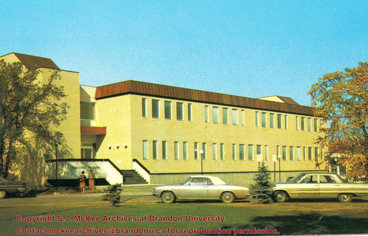
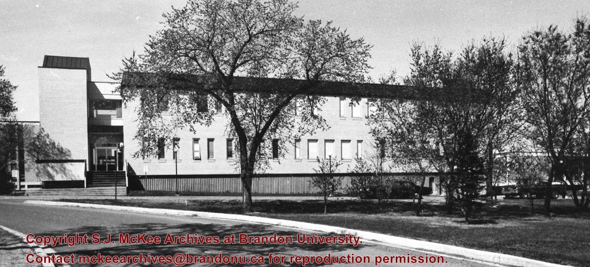
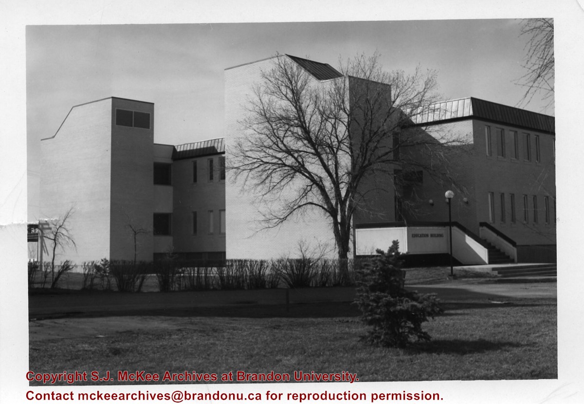
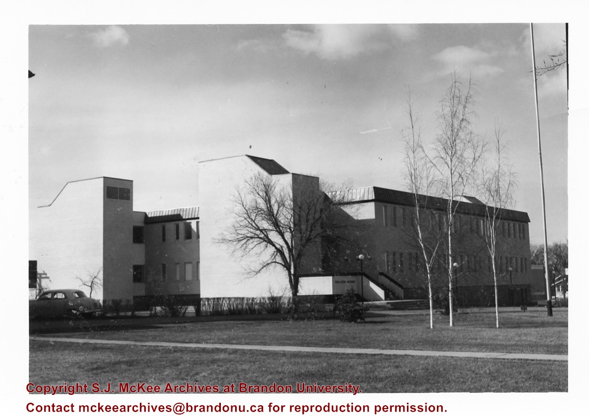
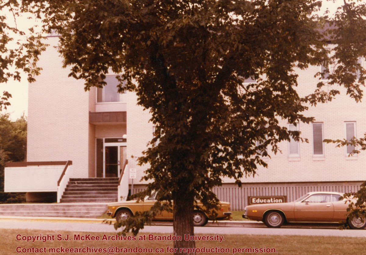
Photograph is looking west southwest and shows the Education Building, including the main entrance. Photograph was taken before the construction of the wheelchair ramp (built in the mid 1980s).
Images
Show Less

Original Music Building and Queen Elizabeth II Music Building

http://archives.brandonu.ca/en/permalink/descriptions8278
Part Of
BUPC 2 Campus buildings
Description Level
Sub-series
GMD
graphic
Date Range
1960s - c.1990
Part Of
BUPC 2 Campus buildings
Description Level
Sub-series
Series Number
2.8
GMD
graphic
Date Range
1960s - c.1990
Physical Description
26 photographs
History / Biographical
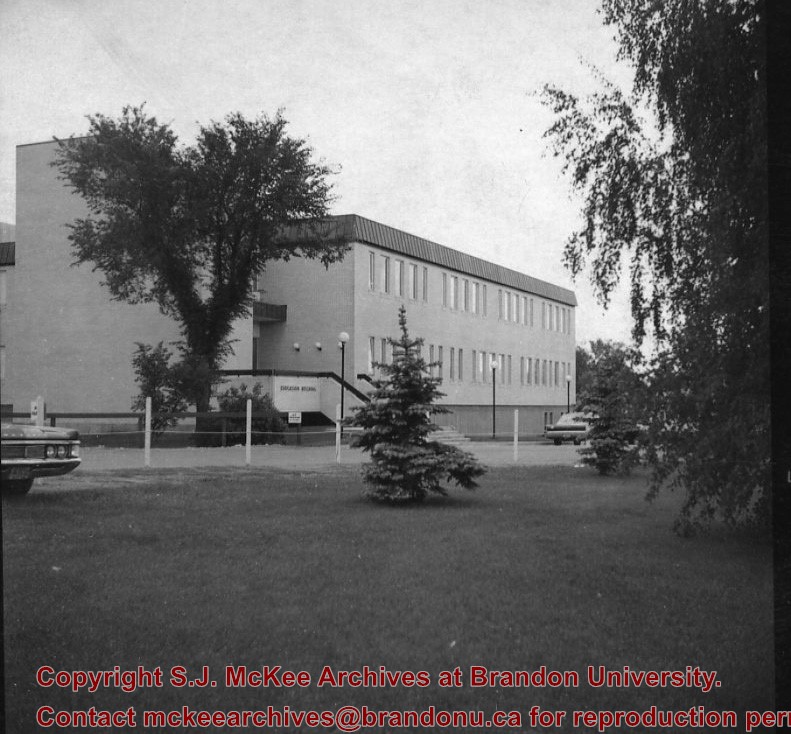
The Original Music Building was completed in 1963. The School of Music moved to the Queen Elizabeth II Music Building in 1985. From c.1986 until 1997, the Original Music Building housed Student Services. Since 1997, the building has been used by the School of Health Studies; a new segment was added to the Original Music Building in 2003 to create the Health Studies Complex.
Scope and Content
Sub-series consists of photographs of the Original Music Building and the Queen Elizabeth II Music Building.
Notes
Queen Elizabeth II Music Building has been abbreviated to QEII Music Building.
Arrangement
All photographs of the Health Studies Complex, which includes the Original Music Building, are part of BUPC sub-series 2.10.
Show Less

Prince Edward Hotel postcard

http://archives.brandonu.ca/en/permalink/descriptions13936
Part Of
Fred McGuinness collection
Description Level
Item
GMD
graphic
Date Range
1940
Accession Number
1-2015
Part Of
Fred McGuinness collection
Creator
Photograph by: Jerrett Photo
Description Level
Item
Series Number
McG 9
Item Number
1-2015.8
Accession Number
1-2015
GMD
graphic
Date Range
1940
Physical Description
5.5" x 3.5" (b/w)
Material Details
postcard
Scope and Content
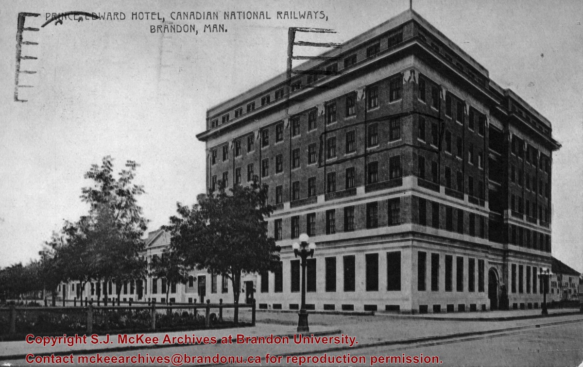
Photograph shows the Prince Edward Hotel and Canadian National Railways Station along Princess Avenue facing southwest.
Notes
Writing on the back of the postcard reads: Novelty Manufacturing & Art Co. Ltd., Montreal. A cancelled George VI brown Canada 2 cent stamp has been postmarked: Regina, Sask, Terminal A., Jul 22 12:30 PM 1940, Save Time, Use Air Mail.
Name Access
Prince Edward Hotel
Princess Avenue
Canadian National Railway
Subject Access
hotels
Brandon business buildings & facilities before 1940
train stations
Storage Location
RG 5 photograph storage drawer 2 (hanging photos)
Arrangement
McG BR#9 - "Ashgrove Farms CBC"
Images
Show Less

Education Building construction

http://archives.brandonu.ca/en/permalink/descriptions8598
Part Of
Education building
Description Level
Item
GMD
graphic
Date Range
c. 1966
Part Of
Education building
Description Level
Item
Series Number
2.7
Item Number Range
2.7.11 to 2.7.87
GMD
graphic
Date Range
c. 1966
Physical Description
4.25" x 3.25" (b/w)
Physical Condition
Some of the photographs have discolored lines through them.
History / Biographical
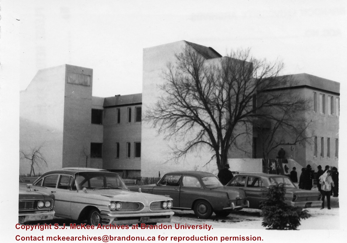
Donkersloot began working at Brandon University in 1971 as the Clerk of Works. From 1973 until his retirement, he was the Director of Physical Plant.
Custodial History
Photographs were taken by Tom Donkersloot during construction and stored in albums in the Physical Plant H-Hut until they were transfered to the McKee Archives by Doug Duncalf in May 2008.
Scope and Content
Seventy seven photographs of the construction of the Education Building.
Notes
Donkersloot recorded the date and time each photograph was taken on the back of the photos.
Show Less

Citizens' Science Building and Knowles-Douglas buildings

http://archives.brandonu.ca/en/permalink/descriptions8274
Part Of
BUPC 2 Campus buildings
Description Level
Sub-series
GMD
graphic
Date Range
c.1980s - c.1990s
Part Of
BUPC 2 Campus buildings
Description Level
Sub-series
Series Number
2.3
GMD
graphic
Date Range
c.1980s - c.1990s
Physical Description
5 photographs
History / Biographical
The Citizens' Science Building was built in 1922 and financed by Brandon citizens. It was renamed the Knowles-Douglas Student Union Centre c. 1984 in honour of Brandon College graduates Stanley Knowles and Tommy Douglas, both of the Class of 1930. The Knowles-Douglas Addition was completed in 1987.
Scope and Content
Sub-series consists of photographs of the Citizens' Science Building and the Knowles-Douglas buildings, which include the Knowles-Douglas Student Union Centre and the Knowles-Douglas Addition.
Show Less

20 records – page 1 of 1.