This negative provides an excellent view of Rosser Avenue (looking east from 10th Street) in the early 20th century, and shows one of the first runs for Brandon's streetcar system.
This image was used as the cover image for Lee Clark's Brandon's Politics & Politicians.
Custodial History
For custodial history see the collection level description of the Lawrence Stuckey collection.
Due to the increasing volume of long-distance auto traffic in the 1920's, the city designated the block between Hill & Queen's Avenues and 9th & 10th streets as a "Tourist Camp" with a few basic facilities. After the demise of the Brandon Municipal Railway, several of the old car bodies were placed in the Tourist Camp to be used as cooking & eating shelters. Some may have had sleeping accommodations. Later (ca. 1938?) several were placed in a row along the south side of Victoria Avenue, approximately 28th or 29th St, and were used as the city's first drive-in hamburger place, "The Train Drive-in". This, I believe, only lasted one or two summer seasons. LAS.
Custodial History
For custodial history see the collection level description of the Lawrence Stuckey collection.
Photograph shows the northwest corner of 10th Street and Princess Avenue. Traffic on the west side of Princess Avenue appears to travelling both ways. A taxi waits at the intersection.
Above the west entrance on the corner building is an electric sign that spells "Hughes Bldg." A second storey has been added to the portion of the Doig's shop that is adjacent to the Alexandra Block.
Built 1906-07; Former Merchants Bank of Canada; Library moved to former Co-op store on 7th Street & Princess Ave in 1984; This building became the Brandon Chamber of Commerce in September of 1985; Façade to remain as heritage building, interior renovations to be conducted with government financing.
Custodial History
For custodial history see the collection level description of the Lawrence Stuckey collection.
Scope and Content
The Merchants Bank of Canada (Western Manitoba Regional Library)
Notes
[Mr. Stuckey wrote on envelope "3 negs." but there is only one in the envelope.]
According to Russ Gourluck (Silver Screens on the Prairie, Winnipeg: Great Plains Publications, 2012, 26), the Orpheum Theatre was in operation from 1917 to 1920 when it then became the Willis Theatre.
Scope and Content
Postcard shows the 100 block of 10th Street facing north. The CPR train station can be seen at the end of 10th Street. The sign for the Rex Cafe is visible on the west side of 10th Street. On the east side of 10th Street, billboards for Campbell & Campbell furniture are visible as well as signs for Pianos and the Orpheum Theatre. Motorists and cyclists share the road. Street car tracks run the length of 10th Street.
Notes
Postcard was manufactured by T.B. [Tichnor Brothers, Inc., 1908-1987] Cambridge, Massachusetts.
Photograph shows the northwest corner of 10th Street and Princess Avenue. Traffic on the west side of Princess Avenue appears to travelling both ways. A car waits at the intersection.
Above the west entrance on the corner building is an electric sign that spells "Hughes Bldg." A second storey has yet to be added to the portion of the Doig's shop that is adjacent to the Alexandra Block.
Fitwell Tailors, a barber shop, and the Federal Building are visible on Princess Avenue.
Notes
A negative is contained in the same enclosure with the print.
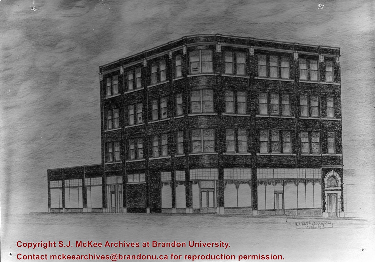
Photograph shows a sketch of the Hughes Building by architect W.H. Shillinglaw. The building, which was erected on the northwest corner of 10th Street and Princess Avenue, had the potential to be four storeys high.


.jpg?width=1200&404=no-img.jpg&watermark=wmk)
.jpg?width=180&404=no-img.jpg)
.jpg?width=1200&404=no-img.jpg&watermark=wmk)
.jpg?width=180&404=no-img.jpg)


.jpg%3fmaxheight%3d1000%26maxwidth%3d1000%26watermark%3dwmk&description=Merchants+Bank+(Public+Library)+Building)
.jpg%3fmaxheight%3d1000%26maxwidth%3d1000%26watermark%3dwmk&description=Merchants+Bank+(Public+Library)+Building)