Skip header and navigation

Revise Search

20 records – page 1 of 1.

Nation & Shewan store window

http://archives.brandonu.ca/en/permalink/descriptions14003
Part Of
Fred McGuinness collection
Description Level
Item
GMD
graphic
Date Range
1914
Accession Number
1-2015
Part Of
Fred McGuinness collection
Description Level
Item
Series Number
McG 9
Item Number
1-2015.73
Accession Number
1-2015
GMD
graphic
Date Range
1914
Physical Description
6.5" x 4.5" (b/w)
Physical Condition
Top left corner is bent
History / Biographical
Erected in 1889, on the southeast corner of Rosser Avenue and 7th Street at 806 Rosser Avenue, this block was designed by Brandon architect W.H. Shillinglaw. At the time of its construction the structure housed the Nation & Shewan Department Store, one of Brandon’s largest and most successful drygoods businesses, owned and operated by Fred Nation and Alexander Shewan. Major improvements were made to the store and an annex was added in 1910. Some of the renovation additions included, but were not limited to, an updated frontage with new copper sash windows and prismatic glass tops, plate glass windows, new fixtures and carpet. With the renovations the floor space of the business was to be almost doubled. The stock of the business also increased, with the Brandon Weekly Sun reporting that when finished, Nation & Shewan would be a “store of which the citizens of Brandon will be justly proud.” The drygoods firm operated until Nation’s death 1926, when it became known as A. Shewan Limited. From 1933 to 1944, the business was known as Shewan and Son. Shortly thereafter, the Metroplitan Stores Ltd began operating out of the Nation & Shewan Block. In 2000, the Town Centre prepared to knock down the Red Apple Building, formerly the Nation & Shewan Block. The demolition was to make way for the new atrium and entrance for the mall, and begin a new period of redevelopment at the downtown shopping centre. [History/Bio written by Christy Henry (SJ McKee Archives) and Eileen Trott (Daly House Museum), researched by Morganna Maylon, for 2015 photographic exhibition "Gowen's Brandon: Then and Now".]
Custodial History
Photograph was given to Fred McGuinness by Linda Bilkoski (nee Lepard) of Lac du Bonnet, MB.
Scope and Content
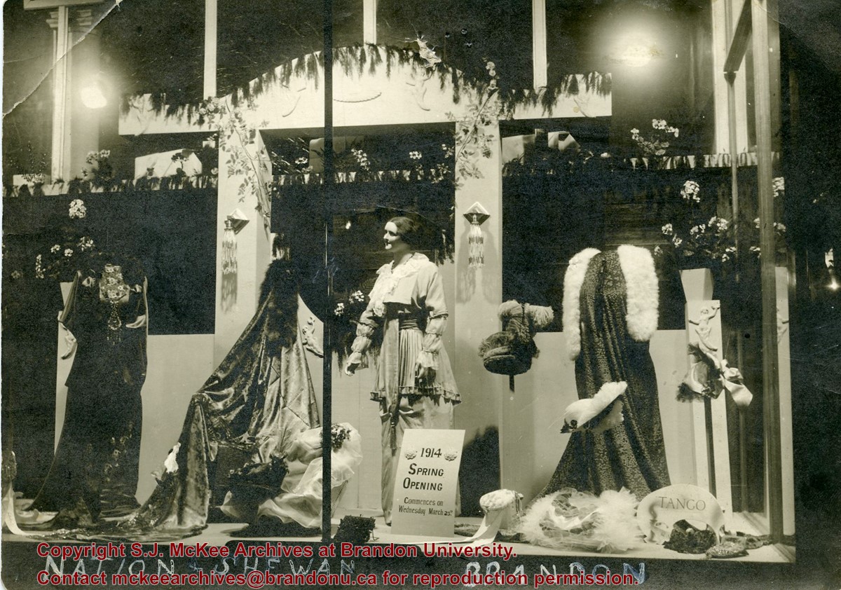
Photograph shows a display of women's clothing and accessories in the window at Nation & Shewan. A sign reads: 1914 Spring Opening commences on Wednesday March 25th.
Notes
Writing on the back of the photograph reads: Mrs. E. Harden, 33-10th St., City. According to the Henderson's Brandon City Directories, Catharine "Kate" Harden (nee Chalmers) worked as a cashier at Nation & Shewan from 1913 to 1914.
Name Access
Nation & Shewan
Kate Harden
Subject Access
building exteriors
advertising
Brandon business buildings & facilities before 1940
Storage Location
RG 5 photograph storage drawer 2 (hanging photos)
Arrangement
McG 4.1 File 27
Images
Show Less

Queen's Hotel on the corner of 10th Street and Rosser Avenue

http://archives.brandonu.ca/en/permalink/descriptions13778
Part Of
Fred McGuinness collection
Description Level
Item
GMD
graphic
Date Range
1883
Accession Number
20-2009
Part Of
Fred McGuinness collection
Description Level
Item
Series Number
McG 9
Item Number
20-2009.89
Accession Number
20-2009
GMD
graphic
Date Range
1883
Physical Description
7.25" x 4.25" (b/w)
Material Details
on matting
Physical Condition
Left hand corner of mat is bent. Mock-up instructions are written in pencil at the bottom right hand corner. Portions of the photograph itself are marked with pen.
History / Biographical
The Queen's Hotel was located on the corner of Rosser Avenue and Tenth Street (Steen & Boyce, 1882. Brandon, Manitoba, Canada and Her Industries. Steen & Boyce Publishers Printers & Binders, 81.). Therefore this photo appears to display Rosser Avenue looking east. P.E. 11/06/09
Scope and Content
Photograph shows early Rosser Avenue under construction between 9th Street and 10th Street in the 1880s. Buildings that line the avenue are wood framed and there are wooden boardwalks in front of a few structures. On the north side of Rosser Avenue signs for Fortier & Bucke Commision Agents and Transit House (Hotel) can be seen. On the south side of Rosser Avenue, the Queen's Hotel and Robinson Brothers and Company groceries and dry goods store are open for business. A family appears to be standing on the stoop at the dry goods store. A boy is lounging in the entryway of the Queen's Hotel. A man is standing on a wooden plank that extends across the dirt road of Rosser Avenue between the dry goods store and the commission agents' shop.
Notes
The back of the photograph reads: FRED McGUINNESS
Name Access
Queen's Hotel
Rosser Avenue
Fortier & Bucke Commision Agents
Transit House
Robinson Brothers and Company
Subject Access
downtown
construction
Brandon Street Scenes Before 1940
hotels
hardware stores
street scenes
store exteriors
building exteriors
grocery stores
general stores
dry goods
Storage Location
RG 5 photograph storage drawer 2 (hanging photos)
Related Material
Lawrence Stuckey collection 1-2002.3.1C17
Images
Show Less

Sewer pipe installation along 700 block of Rosser Avenue

http://archives.brandonu.ca/en/permalink/descriptions13736
Part Of
Fred McGuinness collection
Description Level
Item
GMD
graphic
Date Range
ca. 1906
Accession Number
20-2009
Part Of
Fred McGuinness collection
Description Level
Item
Series Number
McG 9
Item Number
20-2009.46
Accession Number
20-2009
GMD
graphic
Date Range
ca. 1906
Physical Description
6.5" x 4.25" (b/w)
Material Details
on matting
Physical Condition
Photographs have been glued to a backing board that has warped over time
Scope and Content
Photograph shows street view of north side of Rosser Avenue, primarily the 700 block, along which sewer pipe is being laid. Visible buildings and businesses include: The Fleming Block with Lowes Brothers Clothing and Manitoba Farmers Hedge and Wire Fence Company, the Beaubier Block and its Empire Hotel, A.M. Percival (a grocer), the Brandon Hardware Company (600 block), and the Arlington Hotel (500 block) are visible along the north side of the avenue. The Bank of Hamilton Building is on the southeast corner of 8th Street and Rosser Avenue.
Notes
Writing on the front of the photograph matting reads: 290. Page appears to be from a photo album.
Name Access
Fleming Block
Empire Hotel
D.W. Beaubier Block
A.M. Percival
Brandon Hardware Company
Arlington Hotel
Lowes Brothers Clothing
Subject Access
Street scene
downtown
grocers
storefronts
building exteriors
sewage
construction
Storage Location
RG 5 photograph storage drawer 2 (hanging photos)
Images
Show Less

Intersection of Rosser Avenue and 8th Street facing west

http://archives.brandonu.ca/en/permalink/descriptions13786
Part Of
Fred McGuinness collection
Description Level
Item
GMD
graphic
Date Range
[19--]
Accession Number
20-2009
Part Of
Fred McGuinness collection
Creator
Photographer: Brandon Sun
Description Level
Item
Series Number
McG 9
Item Number
20-2009.97
Accession Number
20-2009
GMD
graphic
Date Range
[19--]
Physical Description
8.5" x 5.25" (b/w)
Material Details
reproduction
Scope and Content
Photograph shows the 800 block of Rosser Avenue facing west. On the south side of Rosser Avenue the Nation Block, Christie's Bookstore, and Reesor's Clock can be seen. A number of horse and buggies/carriages are travelling along Rosser Avenue.
Name Access
Rosser Avenue
Reesor’s Jewellery
Reesor's clock
Subject Access
downtown
street scenes
Brandon Street Scenes Before 1940
Transportation
horses
buggies
Storage Location
RG 5 photograph storage drawer 2 (hanging photos)
Images
Show Less

Rosser Avenue viewbook postcard

http://archives.brandonu.ca/en/permalink/descriptions13877
Part Of
Fred McGuinness collection
Description Level
Item
GMD
graphic
Date Range
1927-1929
Accession Number
20-2009
Part Of
Fred McGuinness collection
Creator
Printed by Photogelatine Engraving Co. Ltd., Ottawa
Description Level
Item
Series Number
McG 9
Item Number
20-2009.187
Accession Number
20-2009
GMD
graphic
Date Range
1927-1929
Physical Description
3.5" x 5.5" (colour)
Material Details
postcard
Scope and Content
Photograph shows the 700-block of Rosser Avenue facing west. Visible businesses on the north side of Rosser Avenue include: Burchill's Music Store, E.W. Woolworth Co. Ltd. 5-10 and 15 Cent Store in the E.E. Evans Block, Empire Hotel, and W.A. Paterson Drugs. Automobiles are parked on both sides of the avenue and at the time the photograph was taken, Rosser Avenue was a two-way street.
Notes
Part of "Souvenir of Brandon, Manitoba, Canada [viewbook], Printed by Photogelatine Engraving Co. Limited, Ottawa." Dates obtained from the Burchill's Music Store Henderson's Brandon City Directory listings (1927-1929). Writing on the front of the photograph reads: Rosser St. [sic.] - Brandon, Man.
Name Access
Rosser Avenue
Burchill's Music Store
Evans Block
Empire Hotel
Subject Access
downtown
street scenes
Transportation
automobiles
Brandon business buildings & facilities before 1940
store exteriors
Storage Location
RG 5 photograph storage drawer 2 (hanging photos)
Arrangement
From 20-2009 photos
Images
Show Less

Stores near the corner of Rosser Avenue and 6th Street

http://archives.brandonu.ca/en/permalink/descriptions13783
Part Of
Fred McGuinness collection
Description Level
Item
GMD
graphic
Date Range
1881-1882
Accession Number
20-2009
Part Of
Fred McGuinness collection
Description Level
Item
Series Number
McG 9
Item Number
20-2009.94
Accession Number
20-2009
GMD
graphic
Date Range
1881-1882
Physical Description
9.25" x 6.25" (b/w)
Material Details
on matting
Physical Condition
Corners of photograph mat are bent. Picture is cracked.
Scope and Content
Photograph shows an early view of Brandon's 6th Street in the 1880s. The Winter & O'Neail Groceries & Provisions and James Smart Hardware storefronts have been photographed. A street sign designating 6th Street can be seen below the Winter & O'Neail sign. A horse and cart is parked in front of the grocery store. A number of men wearing hats and jackets are standing along the boardwalk while posing for the picture. Lumber/timber saws are displayed in teh windows of the hardware store.
Notes
Front of photograph reads: 6th Street, Brandon, Manitoba, 1881-1882, Entrance [to Winter & O'Neail] corner of Rosser Ave & 6th Street.
Name Access
James Smart Hardware store
Winter & O'Neail Groceries and Provisions
6th Street
Subject Access
downtown
hardware stores
Pioneers
dry goods
street scenes
Brandon Street Scenes Before 1940
grocery stores
Storage Location
RG 5 photograph storage drawer 2 (hanging photos)
Images
Show Less

10th Street viewbook postcard

http://archives.brandonu.ca/en/permalink/descriptions13876
Part Of
Fred McGuinness collection
Description Level
Item
GMD
graphic
Date Range
1927-1929
Accession Number
20-2009
Part Of
Fred McGuinness collection
Creator
Printed by Photogelatine Engraving Co. Ltd., Ottawa
Description Level
Item
Series Number
McG 9
Item Number
20-2009.186
Accession Number
20-2009
GMD
graphic
Date Range
1927-1929
Physical Description
3.5" x 5.5" (colour)
Material Details
postcard
Scope and Content
Photograph shows a street view of 10th Street facing north. There are many automobiles parked along the street and several pedestrians in summer dress are on the sidewalks and street. Visible business signs include: Hentzman & Co. Pianos (possibly belonging to J.J.H. McLean Co. Ltd.), the Strand Theatre, T & D Clothes, Campbell & Campbell, the CPR Station, and Bowling Alley and Billiards.
Notes
Part of "Souvenir of Brandon, Manitoba, Canada [viewbook], Printed by Photogelatine Engraving Co. Limited, Ottawa." Dates obtained from the Burchill's Music Store Henderson's Brandon City Directory listings (1927-1929). Writing on the front of the photograph reads: 10th St., looking north (C.P.R. Station at end of Street) Brandon, Man.
Name Access
10th Street
Heintzman & Co. Pianos
CPR Station
Strand Theatre
Campbell & Campbell
T & D Clothes
Subject Access
downtown
street scenes
Transportation
automobiles
Brandon business buildings & facilities before 1940
store exteriors
theatres
Storage Location
RG 5 photograph storage drawer 2 (hanging photos)
Arrangement
From 20-2009 photos
Images
Show Less

CPR Station viewbook postcard

http://archives.brandonu.ca/en/permalink/descriptions13878
Part Of
Fred McGuinness collection
Description Level
Item
GMD
graphic
Date Range
1927-1929
Accession Number
20-2009
Part Of
Fred McGuinness collection
Creator
Printed by Photogelatine Engraving Co. Ltd., Ottawa
Description Level
Item
Series Number
McG 9
Item Number
20-2009.188
Accession Number
20-2009
GMD
graphic
Date Range
1927-1929
Physical Description
3.5" x 5.5" (b/w)
Material Details
postcard
Scope and Content
Photograph shows the CPR Train Station on Pacific Avenue and 10th Street.
Notes
Part of "Souvenir of Brandon, Manitoba, Canada [viewbook], Printed by Photogelatine Engraving Co. Limited, Ottawa." Dates obtained from the Burchill's Music Store Henderson's Brandon City Directory listings (1927-1929). Writing on the front of the photograph reads: CPR Station, Brandon, Man.
Name Access
CPR Station
Subject Access
downtown
street scenes
Transportation
train stations
Brandon business buildings & facilities before 1940
store exteriors
Storage Location
RG 5 photograph storage drawer 2 (hanging photos)
Arrangement
From 20-2009 photos
Images
Show Less

Early scene of Rosser Avenue facing west

http://archives.brandonu.ca/en/permalink/descriptions13782
Part Of
Fred McGuinness collection
Description Level
Item
GMD
graphic
Date Range
c.1882
Accession Number
20-2009
Part Of
Fred McGuinness collection
Creator
Photographer: I. Bennetto & Co. (Winnipeg)
Description Level
Item
Series Number
McG 9
Item Number
20-2009.93
Accession Number
20-2009
GMD
graphic
Date Range
c.1882
Physical Description
9.25" x 6.26" (b/w)
Material Details
on matting
Physical Condition
Photograph mat is bent. Emulsion problems with image.
Scope and Content
Photograph shows Rosser Avenue in its incipient stages. Canvas tents are mixed amongst wooden structures. The James Smart Hardware store, Winter & O'Neail Groceries & Provisions, and the law office of F.G.A. Henderson in the Molesworth Block can be seen on the north side of Rosser Avenue. A street sign designating 6th Street can be seen below the Winter & O'Neail sign. A horse and buggie is traveling down the dirt track that is Rosser Avenue. Groups of men can be seen congregating outside some of the local businesses.
Notes
Front of photograph reads: Rosser Avenue, Brandon 1882-1883, from east of Six Street. Back of photograph is stamped: I. Bennetto & Co., Photographers, Opposite Post-Office, Winnipeg, Man.
Name Access
James Smart Hardware store
Winter & O'Neail Groceries and Provisions
F.G.A. Henderson Law Office
Molesworth Block
Rosser Avenue
Subject Access
downtown
hardware stores
Pioneers
dry goods
street scenes
Brandon Street Scenes Before 1940
grocery stores
lawyers
Storage Location
RG 5 photograph storage drawer 2 (hanging photos)
Images
Show Less

Prince Edward Hotel viewbook postcard

http://archives.brandonu.ca/en/permalink/descriptions13880
Part Of
Fred McGuinness collection
Description Level
Item
GMD
graphic
Date Range
1927-1929
Accession Number
20-2009
Part Of
Fred McGuinness collection
Creator
Printed by Photogelatine Engraving Co. Ltd., Ottawa
Description Level
Item
Series Number
McG 9
Item Number
20-2009.190
Accession Number
20-2009
GMD
graphic
Date Range
1927-1929
Physical Description
3.5" x 5.5" (b/w)
Material Details
postcard
Physical Condition
Postcard is water damaged on back and ripped
Scope and Content
Photograph shows a southwest view of the Prince Edward Hotel and train station.
Notes
Part of "Souvenir of Brandon, Manitoba, Canada [viewbook], Printed by Photogelatine Engraving Co. Limited, Ottawa." Dates obtained from the Burchill's Music Store Henderson's Brandon City Directory listings (1927-1929). Writing on the front of the photograph reads: Prince Edward Hotel, Brandon, Man.
Name Access
Prince Edward Hotel
Subject Access
downtown
street scenes
Transportation
train stations
Brandon business buildings & facilities before 1940
store exteriors
hotels
Storage Location
RG 5 photograph storage drawer 2 (hanging photos)
Arrangement
From 20-2009 photos
Images
Show Less

Panorama of Brandon viewbook postcard

http://archives.brandonu.ca/en/permalink/descriptions13879
Part Of
Fred McGuinness collection
Description Level
Item
GMD
graphic
Date Range
1927-1929
Accession Number
20-2009
Part Of
Fred McGuinness collection
Creator
Printed by Photogelatine Engraving Co. Ltd., Ottawa
Description Level
Item
Series Number
McG 9
Item Number
20-2009.189
Accession Number
20-2009
GMD
graphic
Date Range
1927-1929
Physical Description
3.5" x 5.5" (b/w)
Material Details
postcard
Scope and Content
Photograph shows a panorama, bird's-eye-view of downtown Brandon, between Pacific and Rosser Avenues and 7th Street facing east. Photoraph likely taken from the McKenzie Seeds Building. Visible businesses include: Western Canada Flour Mills, Hanbury Hardware Co. Ltd., Cockshutt Plow Co., New Pacific Hotel, Gordon McKay Building, and Arlington Hotel.
Notes
Part of "Souvenir of Brandon, Manitoba, Canada [viewbook], Printed by Photogelatine Engraving Co. Limited, Ottawa." Dates obtained from the Burchill's Music Store Henderson's Brandon City Directory listings (1927-1929). Writing on the front of the photograph reads: Panorama of Brandon, Man.
Name Access
Hanbury Hardware Co. Ltd.
New Pacific Hotel
Cockshutt Plow Co.
Gordon McKay Building
Arlington Hotel
Western Canada Flour Mills
Pacific Avenue
Rosser Avenue
Subject Access
downtown
street scenes
Transportation
train stations
Brandon business buildings & facilities before 1940
store exteriors
hotels
hardware stores
Elevators
Storage Location
RG 5 photograph storage drawer 2 (hanging photos)
Arrangement
From 20-2009 photos
Images
Show Less

William Muir General Grocer building

http://archives.brandonu.ca/en/permalink/descriptions13757
Part Of
Fred McGuinness collection
Description Level
Item
GMD
graphic
Date Range
post-1888
Accession Number
20-2009
Part Of
Fred McGuinness collection
Description Level
Item
Series Number
McG 9
Item Number
20-2009.68
Accession Number
20-2009
GMD
graphic
Date Range
post-1888
Physical Description
4.5" x 7.5" (b/w)
Material Details
on matting
Physical Condition
Matting is bent and has a thumbtack hole.
History / Biographical
According to G.F. Barker (Brandon: A City, 1977, 291), William (Billy) Muir worked at Coombs & Stewart's on Pacific Avenue until he opened his own grocery store in 1888. The shop was located at 143-6th Street, Brandon, and was demolished for a parking lot in 1952.
Custodial History
Donated to Fred McGuinness by Allena Strath (nee Coombs).
Scope and Content
Photograph shows the "Wm. Muir General Grocer" building on 6th Street. Two men pose in the doorway of the store. The man on the left is likely William Muir. Barrels are lined on the boardwalk in front of the store. Apples and mason jars can be seen in the shop's windows.
Notes
Front of photograph reads: Sixth Street between Rosser - Princess. Back of photograph reads: Billy Muir's Store, 143 6th Street Brandon - 57 years in business in this location. An address label affixed to the back of the mat reads: Mrs. James Strath, Box 421, Souris, Man.
Name Access
Coombs & Stewart
Pacific Avenue
6th Street
Wm. Muir General Grocer
Subject Access
Pioneers
general stores
building exteriors
store exteriors
grocery stores
Brandon business buildings & facilities before 1940
Storage Location
RG 5 photograph storage drawer 2 (hanging photos)
Related Material
Lawrence Stuckey collection 1-2002.3.1E18
Images
Show Less

10th Street hydro station stack under repairs

http://archives.brandonu.ca/en/permalink/descriptions13913
Part Of
Fred McGuinness collection
Description Level
Item
GMD
graphic
Date Range
c.1951
Accession Number
20-2009
Part Of
Fred McGuinness collection
Description Level
Item
Series Number
McG 9
Item Number
20-2009.223
Accession Number
20-2009
GMD
graphic
Date Range
c.1951
Physical Description
2.75" x 3.75" (b/w)
Scope and Content
Photograph shows the smoke stack of the 10th Street hydro station under scaffolding, possibly under repair after the 1951 fire/explosion.
Subject Access
construction
Storage Location
RG 5 photograph storage drawer 2 (hanging photos)
Arrangement
From 20-2009 #4 plastic envelope #2
Images
Show Less

Brandon University campus construction

http://archives.brandonu.ca/en/permalink/descriptions8016
Part Of
Brandon University Photograph collection
Description Level
Item
GMD
graphic
Date Range
c. 1996
Part Of
Brandon University Photograph collection
Creator
Photographer: Sandy Black
Description Level
Item
Series Number
2.1
Item Number
BUPC 2.1.82
GMD
graphic
Date Range
c. 1996
Physical Description
4" x 6" (colour)
Scope and Content
View is northeast from the Brandon College Building. Photograph shows the inside of the Brandon College Building after it had been gutted and then partially rebuilt. The exterior fascade of the west side of the building can be clearly seen in this photograph. A number of houses on the east side of 200 block of 18th Street are also visible, as is the stone fence on Princess Avenue and the flag pole on the front lawn.
Subject Access
campus photographs
campus construction
Brandon streets
Images
Show Less

Bird Construction Company Limited trailer

http://archives.brandonu.ca/en/permalink/descriptions8023
Part Of
Brandon University Photograph collection
Description Level
Item
GMD
graphic
Date Range
c. 1996
Part Of
Brandon University Photograph collection
Description Level
Item
Series Number
2.1
Item Number
BUPC 2.1.89
GMD
graphic
Date Range
c. 1996
Physical Description
6" x 4" (colour)
Scope and Content
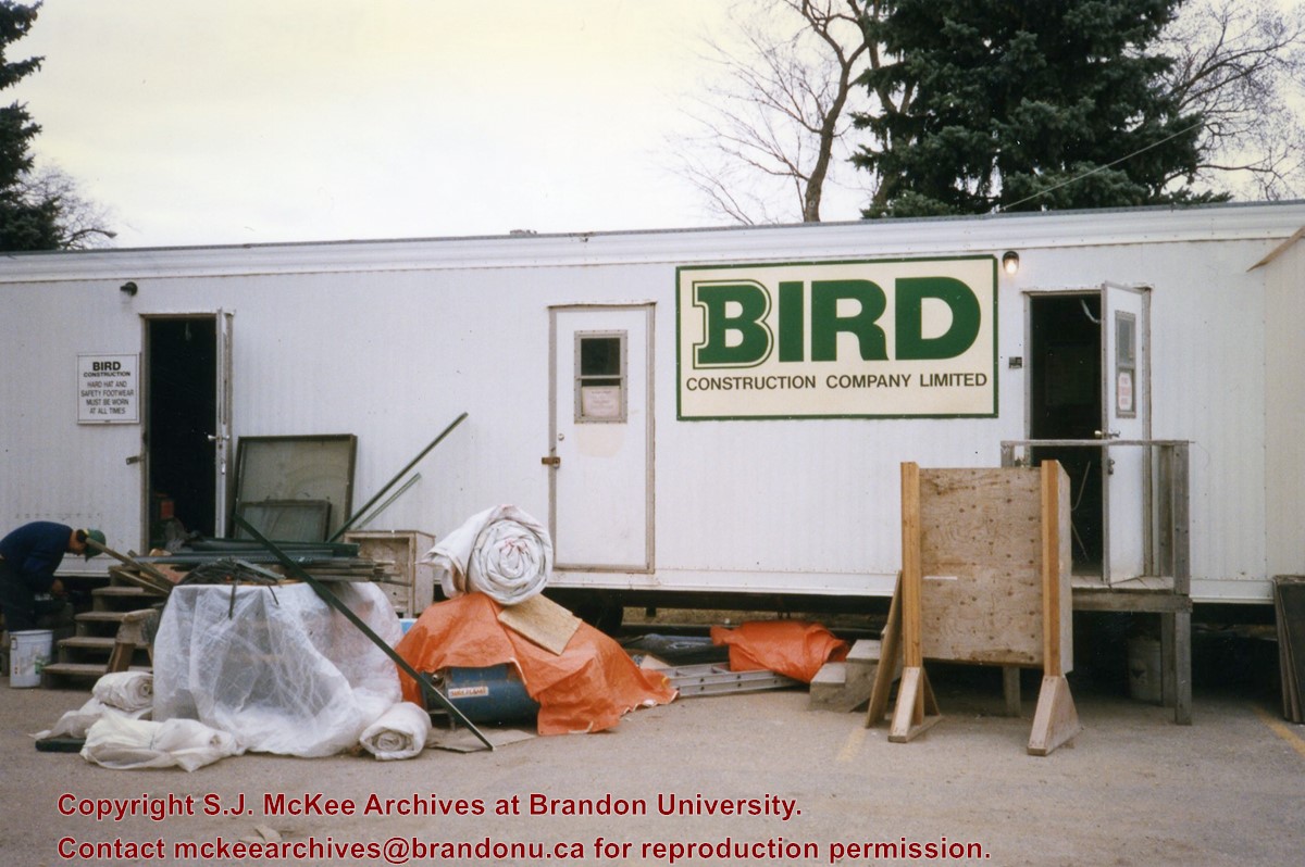
Photograph shows the Bird Construction Company Limited trailer located on the driveway of the Brandon University campus during the renovations to the Brandon College Building and Clark Hall.
Subject Access
campus construction
Images
Show Less

Brandon University campus construction

http://archives.brandonu.ca/en/permalink/descriptions8005
Part Of
Brandon University Photograph collection
Description Level
Item
GMD
graphic
Date Range
c. 1996
Part Of
Brandon University Photograph collection
Creator
Photographer: Sandy Black
Description Level
Item
Series Number
2.1
Item Number
BUPC 2.1.71
GMD
graphic
Date Range
c. 1996
Physical Description
4" x 6" (colour)
Scope and Content
View is northeast probably from the roof of McMaster Hall. Photograph shows the construction of the new roof on Clark Hall and the Brandon College Building. A portion of the east side of the 000 and 100 blocks of 18th Street, as well as the corner of 18th Street and Rosser Avenue are visible in the upper left hand corner. This includes the "Downtown Brandon" sign.
Subject Access
campus photographs
campus buildings
campus construction
Brandon streets
Images
Show Less

Brandon University campus construction

http://archives.brandonu.ca/en/permalink/descriptions8006
Part Of
Brandon University Photograph collection
Description Level
Item
GMD
graphic
Date Range
c. 1996
Part Of
Brandon University Photograph collection
Creator
Photographer: Sandy Black
Description Level
Item
Series Number
2.1
Item Number
BUPC 2.1.72
GMD
graphic
Date Range
c. 1996
Physical Description
6" x 4" (colour)
Scope and Content
View is north northeast probably from the roof of McMaster Hall. Photograph shows the construction of the new roof on Clark Hall and the Brandon College Building, as well as the construction of the extension to Clark Hall and the skywalk. Portions of the city as far north as the Assiniboine River are also visible.
Subject Access
campus photographs
campus buildings
campus construction
Brandon streets
Images
Show Less

Brandon University campus construction

http://archives.brandonu.ca/en/permalink/descriptions8018
Part Of
Brandon University Photograph collection
Description Level
Item
GMD
graphic
Date Range
c. 1996
Part Of
Brandon University Photograph collection
Description Level
Item
Series Number
2.1
Item Number
BUPC 2.1.84
GMD
graphic
Date Range
c. 1996
Physical Description
6" x 4" (colour)
Scope and Content
View is north northeast from the roof of McMaster Hall. Photograph shows the campus under construction during the renovation of the Brandon College Building and Clark Hall. The photograph was taken in late fall after the roof had been removed from the buildings but before the construction of the extension of Clark Hall. Construction materials litter the courtyard and driveway. The view looking north extends to The North Hill - a number of residential blocks, particularly to the northeast of 18th Street are visible. Buildings include the International Harvester Building and Kin Village.
Subject Access
campus photographs
campus buildings
campus construction
Brandon streets
Images
Show Less

Brandon University campus construction

http://archives.brandonu.ca/en/permalink/descriptions8020
Part Of
Brandon University Photograph collection
Description Level
Item
GMD
graphic
Date Range
c. 1996
Part Of
Brandon University Photograph collection
Creator
Photographer: Sandy Black
Description Level
Item
Series Number
2.1
Item Number
BUPC 2.1.86
GMD
graphic
Date Range
c. 1996
Physical Description
6" x 4" (colour)
Scope and Content
View is north northeast probably from the roof of McMaster Hall. Photograph shows the construction of the new roof on Clark Hall and the Brandon College Building, as well as the construction of the extension to Clark Hall and the skywalk. The view looking north extends to The North Hill - a number of residential blocks, particularly to the northeast of 18th Street are visible. Buildings include the International Harvester Building and Kin Village.
Subject Access
campus photographs
campus buildings
campus construction
Brandon streets
Images
Show Less

Brandon Wheat Market at Pacific Avenue and 10th Street

http://archives.brandonu.ca/en/permalink/descriptions13795
Part Of
Fred McGuinness collection
Description Level
Item
GMD
graphic
Date Range
1885
Accession Number
20-2009
Part Of
Fred McGuinness collection
Description Level
Item
Series Number
McG 9
Item Number
20-2009.104
Accession Number
20-2009
GMD
graphic
Date Range
1885
Physical Description
9.25" x 7.25" (b/w)
Material Details
On matting
Physical Condition
Photograph is creased and scratched
Scope and Content
Photograph shows the Brandon Wheat Market along Pacific Avenue on November 30, 1885. Farmers can be seen driving wagon teams loaded with bags of grain in line on Pacific Avenue from 10 Street to at least 7th Street. On the north side of Pacific Avenue the CPR Land Office and grain elevators are pictured. On the south side of Pacific Avenue, the general merchant/hardware store Bower, Blackburn, Mundell & Porter is situated on the corner of Pacific Avenue and 10th Street. A 10th Street sign is affixed to the merchants' store. On the east side of the general store, Edie House, the Grand View Hotel, and a Farmers' boarding and lodging house can be seen. Most of the buildings appear to be woodframed except for the Grand View, which is constructed of brick. Sidewalks appear to be in place on the south side of Pacific and snow dusts the streets. A baby swathed in winter clothing sits in a pram/baby carriage in front of the general store.
Notes
Writing on the front of the photograph reads: Novemeber 30th, 1885, Brandon Wheat Market
Name Access
Bower, Blackburn, Mundell, & Porter
Edie House
Grand View Hotel
Pacific Avenue
10th Street
CPR Land Office
Brandon Wheat Market
Subject Access
horses
wagons
Transportation
street scenes
hotels
markets
Grain elevators
downtown
Brandon business buildings & facilities before 1940
store exteriors
winter
general stores
hardware stores
children
Storage Location
McGuinness oversize storage drawer (1-2015)
Related Material
Lawrence Stuckey collection 1-2002.3.1C3
Images
Show Less

20 records – page 1 of 1.