Photograph shows the north face of the Prince Edward Hotel on Princess Avenue. To the east of the hotel is Old City Hall with the military monument (which has since been relocated to the Brandon Armoury). On the west side of the hotel is Wheelers Esso Service Station.
Notes
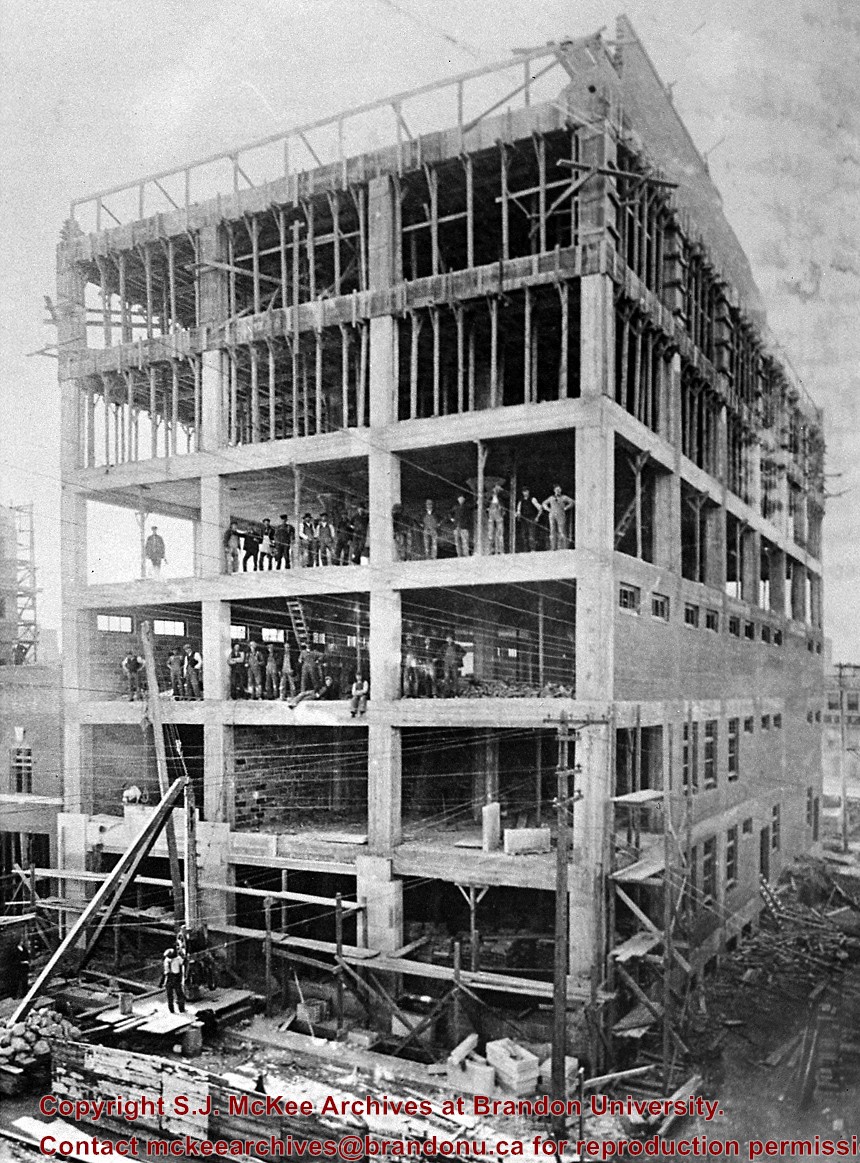
The photograph appears to be taken from the Hughes Building on 10th Street.
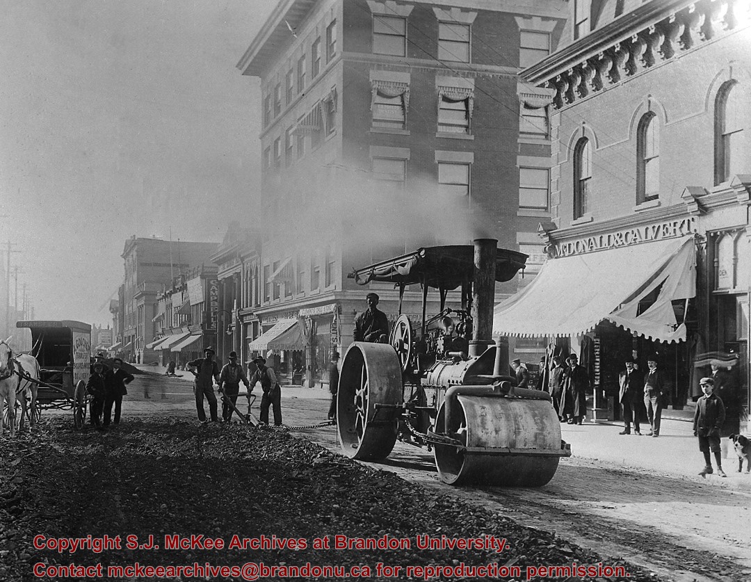
Excavated earth was loaded into a hopper, which itself was on a rail running a half block back. It was then dumped back to fill the trench where pipe installation had already been completed - Art Baker (of Art's Confectionery, NE 15th St. & Princess Ave.). This information was provided in response to a request in the Brandon Sun (Fred McGuinness) for further information.
Custodial History
For custodial history see the collection level description of the Lawrence Stuckey collection.
Scope and Content
Brandon sewer line construction
Notes
View of Pacific Avenue, looking east from 5th Street
The Queen's hotel was located on the corner of Rosser Avenue and Tenth Street (Steen & Boyce, 1882. Brandon, Manitoba, Canada and Her Industries. Steen & Boyce Publishers Printers & Binders, 81.). Therefore this photo appears to display Rosser Avenue looking east. P.E. 11/06/09
Custodial History
For custodial history see the collection level description of the Lawrence Stuckey collection.
Scope and Content
Queen's Hotel, Robinson Bros. & Co. Drygoods, etc.
Notes
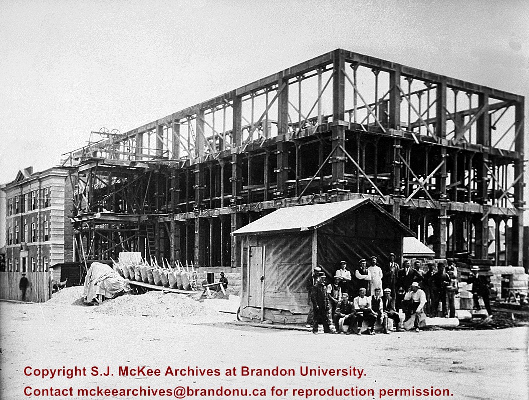
Street scene with new construction. Collection: Fred McGuinness
Left hand corner of mat is bent. Mock-up instructions are written in pencil at the bottom right hand corner. Portions of the photograph itself are marked with pen.
History / Biographical
The Queen's Hotel was located on the corner of Rosser Avenue and Tenth Street (Steen & Boyce, 1882. Brandon, Manitoba, Canada and Her Industries. Steen & Boyce Publishers Printers & Binders, 81.). Therefore this photo appears to display Rosser Avenue looking east. P.E. 11/06/09
Scope and Content
Photograph shows early Rosser Avenue under construction between 9th Street and 10th Street in the 1880s. Buildings that line the avenue are wood framed and there are wooden boardwalks in front of a few structures. On the north side of Rosser Avenue signs for Fortier & Bucke Commision Agents and Transit House (Hotel) can be seen. On the south side of Rosser Avenue, the Queen's Hotel and Robinson Brothers and Company groceries and dry goods store are open for business. A family appears to be standing on the stoop at the dry goods store. A boy is lounging in the entryway of the Queen's Hotel. A man is standing on a wooden plank that extends across the dirt road of Rosser Avenue between the dry goods store and the commission agents' shop.
For custodial history see the collection level description of the Lawrence Stuckey collection.
Scope and Content
West side of Sixth Street, north of Rosser Avenue; looking north
Notes
Businesses displayed (S to N) include: Winter & O'Neill - general store; James A. Smart - hardware; Grand Central Hotel - built 1882, razed 1890; American House - hotel; Brandon House (far end) - hotel
For custodial history see the collection level description of the Lawrence Stuckey collection.
Scope and Content
View of Assiniboine Avenue running west, from Ninth Street North
Notes
Second building from right - Westbrook & Fairchild Implements. At left - Western Hotel; Data [courtesy of] Roy Brown from Henderson's [Directory]; From Manitoba Archives
For custodial history see the collection level description of the Lawrence Stuckey collection.
Scope and Content
View of the southeast corner of Tenth Street and Princess Avenue, showing the Prince Edward Hotel (left) and an Imperial Oil Building (right).
Notes
The second floor of the Imperial Oil building became the Imperial Dance Garden in 1934. The small wooden post in a concrete foundation in the centre of the intersection was called a "Silent Policeman". You were supposed to keep it on your left while making a left turn. They took quite a beating.
[Information in "Notes" provided by the Fred McGuinness collection (20-2009).]
Photograph shows the Greyhound Bus Depot at 11th Street and Princess Avenue. Western Motors, Wheelers Esso Station, and the Prince Edward Hotel are visible along the south side of Princess Avenue. Traffic is travelling one-way on Princess Avenue.
Photograph shows Princess Avenue facing east from 10th Street. On the north side of Princess Avenue, a B/A Service Station, Princess Cafe, Lindenberg Seeds, and the Central Fire Station are visible. Old City Hall with the war memorial and the Prince Edward Hotel are visible on the south side of Princess Avenue. Traffic is travelling one-way on Princess Avenue.
Photograph shows the 800 block of Rosser Avenue facing west. On the south side of Rosser Avenue the Nation Block, Christie's Bookstore, and Reesor's Clock can be seen. A number of horse and buggies/carriages are travelling along Rosser Avenue.


