For custodial history see the collection level description of the Lawrence Stuckey collection.
Scope and Content
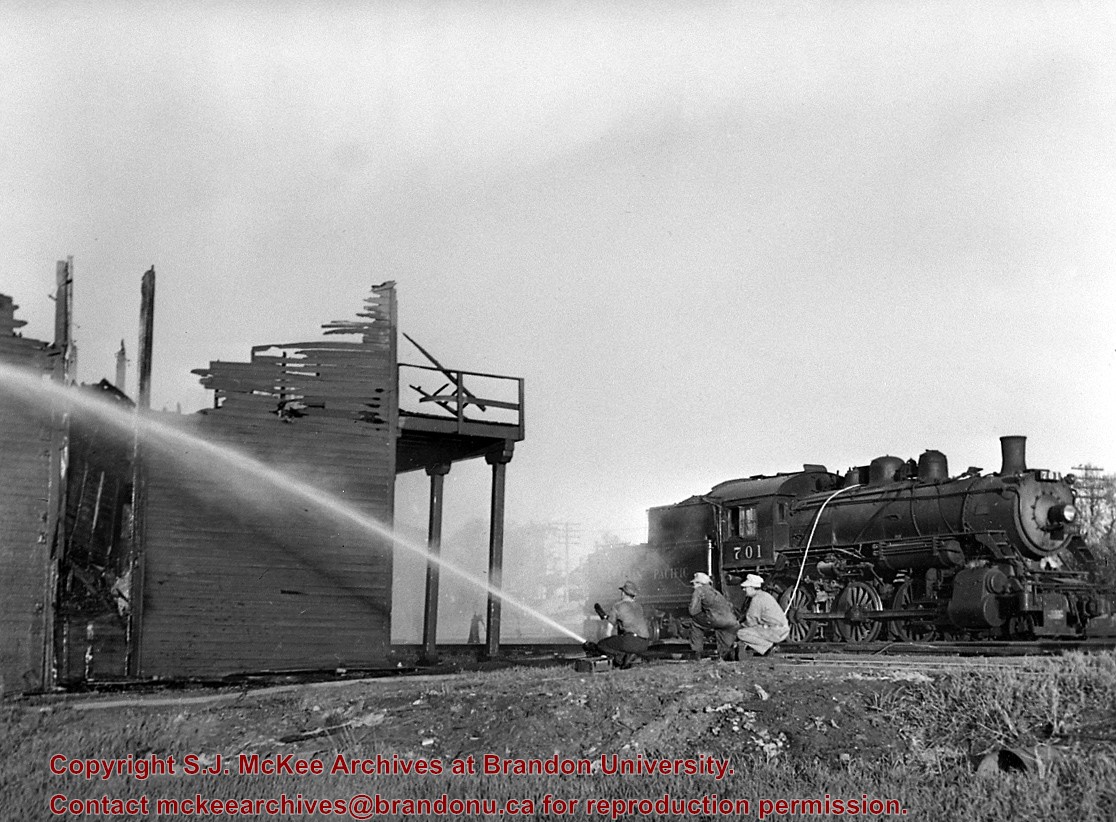
CPR Ice House Fire with engine 701
Notes
This large ice house, located between the CPR tracks and Assiniboine Avenue at 3rd Street, was filled with blocks of ice from the Assiniboine River each winter. It had a long high platform for [loading ice blocks into] refrigerator cars, and also handled charcoal braziers for heating these same cars in winter. The new ice house structure that was built after this fire was much smaller, as it had an artificial ice plant.
With mechanically temperature-controlled cars replacing ice-cooled refrigerators, it was demolished in the 1970's.
This photograph shows how steam switch engines were used as fire engines. A hose carried in a box under the tender was fitted into a branch of the boiler feed pipe (discharge pipe). When the injector was turned on it gave a nozzle pressure of over 200 psi.
These blocks of ice were used to fill the ice houses of the Wheat City Ice Co. (located north of Rosser Avenue on the west side of 15th Street, and south of Princess Avenue on the east side of 17th Street), the CPR icehouses (at the station and 3rd St. & Assiniboine Ave), and the CNR icehouse (at Forth Street and McTavish Avenue). In addition, large quantities of ice were shipped to smaller towns in railcars (usually old refrigerator cars).
Custodial History
For custodial history see the collection level description of the Lawrence Stuckey collection.
Scope and Content
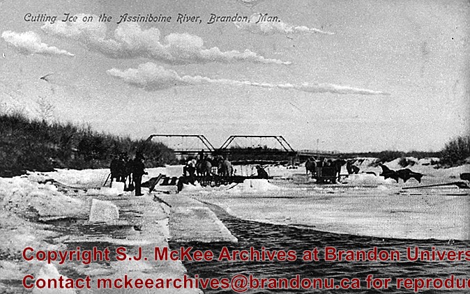
Cutting ice from the Assiniboine River
Notes
This is one of five images that show the method in which ice is cut into blocks and loaded onto sleighs or trucks. Note the large draft horses still in use at this date.
[Mr. Stuckey put five negatives into the same envelope. We have separated them and numbered them H12(1) to H12(5).]
Additional information provided by the Fred McGuinness collection (20-2009).
These blocks of ice were used to fill the ice houses of the Wheat City Ice Co. (located north of Rosser Avenue on the west side of 15th Street, and south of Princess Avenue on the east side of 17th Street), the CPR icehouses (at the station and 3rd St. & Assiniboine Ave), and the CNR icehouse (at Forth Street and McTavish Avenue). In addition, large quantities of ice were shipped to smaller towns in railcars (usually old refrigerator cars).
Custodial History
For custodial history see the collection level description of the Lawrence Stuckey collection.
Scope and Content
Cutting ice from the Assiniboine River
Notes
This is one of five images that show the method in which ice is cut into blocks and loaded onto sleighs or trucks. Note the large draft horses still in use at this date.
[Mr. Stuckey put five negatives into the same envelope. We have separated them and numbered them H12(1) to H12(5).]
Additional information provided by the Fred McGuinness collection (20-2009).
Contains the following files:
9.1 Class list and lost alumni 1941-1948
9.2 "Spectrum" April 1944
9.3 "The Sickle" 1941-1945 (missing 1944)
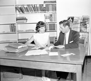
9.4 Graduation programmes 1927, 1940-1952 (includes photo of Arts Banquet, Brandon College 1942)
9.5 "The New Era" 1947
9.6 Murray McPherson diary 1942
9.7 The Quill and The Sickle account book [1939-1941]
9.8 Brandon College documentation 1942-1943
9.9 Calendar 1940-1941
9.10 Murray McPherson's notes 1938-1939 (Brandon Collegiate)
9.11 Brandon College notes [1941-1944] (2 files)
9.12 Commencement programme 1944
9.13 Brandon College commencement programmes 1944, 1945, 1952 (also contains 1937-1938 Brandon College calendar and a copy of "S.J. McKee of Brandon College" by Tommy McLeod)
9.14 Physics notes [1942]
9.15 Murray McPherson - math and physics notes 1943
9.16 Murray McPherson - math notes 1944
9.17 Murray McPherson account book 1938-1940 (Brandon Collegiate)
9.18 Miscellaneous pamphlets re: Brandon College and hockey 1909 - ca.1945 (including Student Handbooks 1940-1944 and the 1913 convocation programme, the 1909 Manitoba Amateur Hockey Association constitution, pamphlets from The Boys' Brigade and a pamphlet with etiquette and manner advice for teenagers)
Notes
Part of the Alfred Angus Murray McPherson collection.
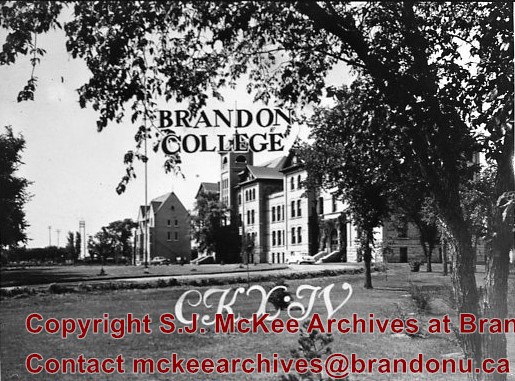
Photograph is looking northwest probably from the northwest corner of 18th Street and Louise Avenue. The photographer was laying down when s/he took the shot. Photograph shows the field to the south of the Citizens' Science Building, as well as the Citizens' Science Building, part of the Brandon College Building and Clark Hall, and two H-Huts. The photo was taken in summer as the field is full of dandelions.
View is southwest. Photograph shows Clark Hall, the Brandon College Building, the Citizens' Science Building and the driveway running in front of the buildings. Portions of the front lawn and the Kinsmen Staduim are also visible.
View is northwest from the front lawn. Photograph shows the Citizens' Science Building, an H-Hut, the Brandon College Building, Clark Hall and the original Music Building.
View is south southwest from approximatley the location of the current Health Studies Complex. Photograph shows the large field to the north of Clark Hall, Clark Hall, the Brandon College Building, the Citizens' Science Building and an H-Hut behind Clark Hall.
See fonds level of the CKX records for custodial history.
Scope and Content
Image is looking southwest across Brandon College campus. Visible are Clark Hall, the Brandon College Building, the Citizens' Science Building and the A.E. McKenzie Building.
See fonds level of the CKX records for custodial history.
Scope and Content
Image is looking northwest across Brandon College campus. Visible are the H-Huts and the Citizen's Science Building. Behind the Citizen's Science Building are the Brandon College Building and Clark Hall.
See fonds level of the CKX records for custodial history.
Scope and Content
Image is looking south southwest across Brandon College campus. Visible are Clark Hall, the Brandon College Building and the Citizens' Science Building.
.jpg?width=1200&404=no-img.jpg&watermark=wmk)
.jpg?width=180&404=no-img.jpg)
.jpg?width=1200&404=no-img.jpg&watermark=wmk)
.jpg?width=180&404=no-img.jpg)
.jpg?width=1200&404=no-img.jpg&watermark=wmk)
.jpg?width=180&404=no-img.jpg)
.jpg?width=1200&404=no-img.jpg&watermark=wmk)
.jpg?width=180&404=no-img.jpg)
.jpg?width=1200&404=no-img.jpg&watermark=wmk)
.jpg?width=180&404=no-img.jpg)


.jpg%3fmaxheight%3d1000%26maxwidth%3d1000%26watermark%3dwmk&description=Cutting+Ice+from+the+Assiniboine+River)
.jpg%3fmaxheight%3d1000%26maxwidth%3d1000%26watermark%3dwmk&description=Cutting+Ice+from+the+Assiniboine+River)
.jpg%3fmaxheight%3d1000%26maxwidth%3d1000%26watermark%3dwmk&description=Cutting+Ice+from+the+Assiniboine+River)
.jpg%3fmaxheight%3d1000%26maxwidth%3d1000%26watermark%3dwmk&description=Cutting+Ice+from+the+Assiniboine+River)
.jpg%3fmaxheight%3d1000%26maxwidth%3d1000%26watermark%3dwmk&description=Cutting+Ice+from+the+Assiniboine+River)