Skip header and navigation

Revise Search

20 records – page 2 of 1.

Aerial view: Brandon College campus

http://archives.brandonu.ca/en/permalink/descriptions8272
Part Of
Aerial views and campus photographs
Description Level
Item
GMD
graphic
Date Range
c. 1964
Part Of
Aerial views and campus photographs
Description Level
Item
Series Number
2.1
Item Number
2.1.1
GMD
graphic
Date Range
c. 1964
Physical Description
4" x 5" (b/w)
Scope and Content
Photograph is looking northwest from approximately the southeast corner of 18th Street and Louise Avenue.
Name Access
Flora Cowan Residence
Subject Access
Aerial views Brandon College
Images
Show Less

Aerial view: Brandon College campus

http://archives.brandonu.ca/en/permalink/descriptions622
Part Of
Aerial views and campus photographs
Description Level
Item
GMD
graphic
Date Range
c. 1962
Part Of
Aerial views and campus photographs
Description Level
Item
Series Number
2.1
Item Number
2.1.20
GMD
graphic
Date Range
c. 1962
Physical Description
10" x 8" (b/w)
Scope and Content
View is northwest from approximately the corner of 18th Street and Louise Avenue. Photograph shows the Brandon College campus after the completion of Flora Cowan Hall.
Notes
BUPC 2.1.24 is a smaller version of this photograph.
Images
Show Less

Aerial view: Brandon College campus looking northwest

http://archives.brandonu.ca/en/permalink/descriptions616
Part Of
Aerial views and campus photographs
Description Level
Item
GMD
graphic
Date Range
c. 1963
Part Of
Aerial views and campus photographs
Description Level
Item
Series Number
2.1
Item Number
2.1.24
GMD
graphic
Date Range
c. 1963
Physical Description
5" x 4" (b/w)
Scope and Content
View is northwest from approximately the corner of 18th Street and Louise Avenue. Photograph shows the Brandon College campus after the completion of Flora Cowan Hall.
Notes
BUPC 2.1.20 is a larger version of this photograph.
Images
Show Less

Aerial view: Brandon College campus and Kinsmen Park

http://archives.brandonu.ca/en/permalink/descriptions621
Part Of
Aerial views and campus photographs
Description Level
Item
GMD
graphic
Date Range
c. 1962
Part Of
Aerial views and campus photographs
Description Level
Item
Series Number
2.1
Item Number
2.1.19
GMD
graphic
Date Range
c. 1962
Physical Description
10" x 8" (b/w)
Physical Condition
The bottom right hand corner has been torn off. Both portions of the photograph are stored together.
Scope and Content
View is northwest from approximately 17th Street and Victoria Avenue. Photograph shows: the Brandon College campus and the Kinsmen Park and baseball diamond. Taken during construction of Flora Cowan Hall but before the Gymnasium was built.
Images
Show Less

Brandon College north driveway entrance

http://archives.brandonu.ca/en/permalink/descriptions8070
Part Of
Aerial views and campus photographs
Description Level
Item
GMD
graphic
Date Range
c. 1964
Part Of
Aerial views and campus photographs
Description Level
Item
Series Number
2.1
Item Number
2.1.139
GMD
graphic
Date Range
c. 1964
Physical Description
10" x 8" (b/w)
Scope and Content
View is southwest from the north side of Princess Avenue. Photograph shows the north driveway entrance on campus. The original Music Building, the A.E. McKenzie Building, Clark Hall and part of the Brandon College Building are visible.
Images
Show Less

Brandon from river bend north

http://archives.brandonu.ca/en/permalink/descriptions11499
Part Of
CKX fonds
Description Level
Item
GMD
graphic
Date Range
after 1954
Accession Number
11-2010
Part Of
CKX fonds
Creator
CKX
Description Level
Item
Item Number
11-2010.B75
Accession Number
11-2010
GMD
graphic
Date Range
after 1954
Physical Description
1.5" x 1" (b/w)
Material Details
Negative
Custodial History
See fonds level of the CKX records for custodial history.
Scope and Content
Image of Brandon viewed from a bend in the Assiniboine River north of the city.
Name Access
CKX Television
Brandon, Manitoba
Subject Access
landscapes
Landscape Photography
Storage Location
CKX fonds - 2010 accessions
Images
Show Less

Aerial view: Brandon College from 23rd Street

http://archives.brandonu.ca/en/permalink/descriptions602
Part Of
Brandon University Photograph collection
Description Level
Item
GMD
graphic
Date Range
[1963-1966]
Part Of
Brandon University Photograph collection
Description Level
Item
Series Number
2.1
Item Number
BUPC 2.1.9
GMD
graphic
Date Range
[1963-1966]
Physical Description
5" x 4" (b/w)
Scope and Content
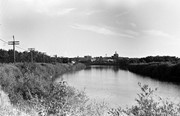
Image is looking east northeast from approximately the 300 block of 23rd Street between Lorne and Louise Avenues. Photograph shows the Brandon College campus after the opening of the original Music Building in 1963, but before the construction of the Education Building in 1966. A number of house on the 300 blocks of 22nd and 21st Streets are visible in the foreground, with the A.E. McKenzie Seed Co., the Prince Edward Hotel and various grain elevators on the horizon.
Subject Access
aerial photographs
campus photographs
campus buildings
Brandon streets
Grain elevators
Images
Show Less

Brandon University campus

http://archives.brandonu.ca/en/permalink/descriptions7997
Part Of
Brandon University Photograph collection
Description Level
Item
GMD
graphic
Date Range
c. 1996
Part Of
Brandon University Photograph collection
Creator
Photographer: Sandy Black
Description Level
Item
Series Number
2.1
Item Number
BUPC 2.1.63
GMD
graphic
Date Range
c. 1996
Physical Description
6" x 4" (colour)
Scope and Content
View is northwest from the roof of the John R. Brodie Science Centre. Photograph shows the roof of the Knowles Douglas Students' Union Centre, the Citizens' Science Building, and the Brandon College Building and Clark Hall during renovation.
Subject Access
campus photographs
campus buildings
campus construction
Images
Show Less

Brandon University campus

http://archives.brandonu.ca/en/permalink/descriptions7998
Part Of
Brandon University Photograph collection
Description Level
Item
GMD
graphic
Date Range
c. 1993
Part Of
Brandon University Photograph collection
Description Level
Item
Series Number
2.1
Item Number
BUPC 2.1.64
GMD
graphic
Date Range
c. 1993
Physical Description
6" x 4" (colour)
Scope and Content
Photograph was taken from the roof of the Library and shows the walkway and flower bed on the southeast corner of the George T. Richardson Centre. The Physical Plant H-Hut is visible in the top right hand corner.
Subject Access
campus photographs
Images
Show Less

Brandon University campus

http://archives.brandonu.ca/en/permalink/descriptions7999
Part Of
Brandon University Photograph collection
Description Level
Item
GMD
graphic
Date Range
c. 1993
Part Of
Brandon University Photograph collection
Description Level
Item
Series Number
2.1
Item Number
BUPC 2.1.65
GMD
graphic
Date Range
c. 1993
Physical Description
4" x 6" (colour)
Scope and Content
View is southwest from the roof of the George T. Richardson Centre. Photograph shows the curved glass wall of the John E. Robbins Library, the walkway between the Library and the Dining Hall, the Dining Hall and Darrach Hall.
Subject Access
campus photographs
campus buildings
Images
Show Less

Brandon University campus

http://archives.brandonu.ca/en/permalink/descriptions8026
Part Of
Aerial views and campus photographs
Description Level
Item
GMD
graphic
Date Range
c. 1996
Part Of
Aerial views and campus photographs
Description Level
Item
Series Number
2.1
Item Number
2.1.93
GMD
graphic
Date Range
c. 1996
Physical Description
6" x 4" (colour)
Scope and Content
View is east northeast from the sidewalk on the southeast corner of the George T. Richardson Centre (John R. Robbins Library). Photographs shows the campus during winter, including the Physical Plant and Development H-Huts, as well as the Brandon College Building and Clark Hall after the majority of the renovations were completed.
Images
Show Less

Brandon University campus

http://archives.brandonu.ca/en/permalink/descriptions8027
Part Of
Aerial views and campus photographs
Description Level
Item
GMD
graphic
Date Range
c. 1985
Part Of
Aerial views and campus photographs
Description Level
Item
Series Number
2.1
Item Number
2.1.94
GMD
graphic
Date Range
c. 1985
Physical Description
5" x 3.5" (colour)
Scope and Content
View is southwest from 18th Street, just north of the Brandon University sign. Tken during the summer, the photograph shows the front lawn, a portion of the flower bed, the Citizens' Science Building, the Knowles Douglas Students' Union Centre, the John R. Brodie Science Centre and McMaster Hall.
Images
Show Less

Brandon University campus

http://archives.brandonu.ca/en/permalink/descriptions8028
Part Of
Aerial views and campus photographs
Description Level
Item
GMD
graphic
Date Range
c. 1980s
Part Of
Aerial views and campus photographs
Description Level
Item
Series Number
2.1
Item Number
2.1.95
GMD
graphic
Date Range
c. 1980s
Physical Description
5" x 3.5" (colour)
Scope and Content
View is northeast. Photograph shows the green space before the Library extension in 1993. Brandon College Building and the Development H-Hut in the background.
Images
Show Less

Brandon University campus

http://archives.brandonu.ca/en/permalink/descriptions8029
Part Of
Aerial views and campus photographs
Description Level
Item
GMD
graphic
Date Range
c. 1988
Part Of
Aerial views and campus photographs
Description Level
Item
Series Number
2.1
Item Number
2.1.96
GMD
graphic
Date Range
c. 1988
Physical Description
5" x 3.5" (colour)
Scope and Content
View is northwest from the roof of the John R. Brodie Science Centre. Photograph shows part of McMaster Hall, the H-Huts, the Citzens' Science Building, the Brandon College Building and Clark Hall, the driveway, the J.R.C. Evans Lecture Theatre, the A.E. McKenzie Building and the Queen Elizabeth II Music Building.
Images
Show Less

Brandon University campus

http://archives.brandonu.ca/en/permalink/descriptions8030
Part Of
Aerial views and campus photographs
Description Level
Item
GMD
graphic
Date Range
c. early 1990s
Part Of
Aerial views and campus photographs
Description Level
Item
Series Number
2.1
Item Number
2.1.97
GMD
graphic
Date Range
c. early 1990s
Physical Description
4" x 6" (b/w)
Scope and Content
View is north from the Knowles Douglas Students' Union Centre looking down the driveway toward Princess Avenue.
Images
Show Less

Brandon University campus

http://archives.brandonu.ca/en/permalink/descriptions8031
Part Of
Aerial views and campus photographs
Description Level
Item
GMD
graphic
Date Range
c. 1995
Part Of
Aerial views and campus photographs
Description Level
Item
Series Number
2.1
Item Number
2.1.98
GMD
graphic
Date Range
c. 1995
Physical Description
6" x 4" (colour)
Scope and Content
View is northwest from the sidewalk on the west side of 18th Street. Photograph shows the John R. Brodie Science Centre sign, McMaster Hall and its entrance, the lawn in from of McMaster Hall, a portion of the Knowles Douglas Students' Union Centre and the Citizens' Science Building.
Images
Show Less

Brandon University campus

http://archives.brandonu.ca/en/permalink/descriptions8032
Part Of
Aerial views and campus photographs
Description Level
Item
GMD
graphic
Date Range
c. 2000
Part Of
Aerial views and campus photographs
Creator
Photographer: Sandy Black
Description Level
Item
Series Number
2.1
Item Number
2.1.99
GMD
graphic
Date Range
c. 2000
Physical Description
6" x 4" (colour)
Scope and Content
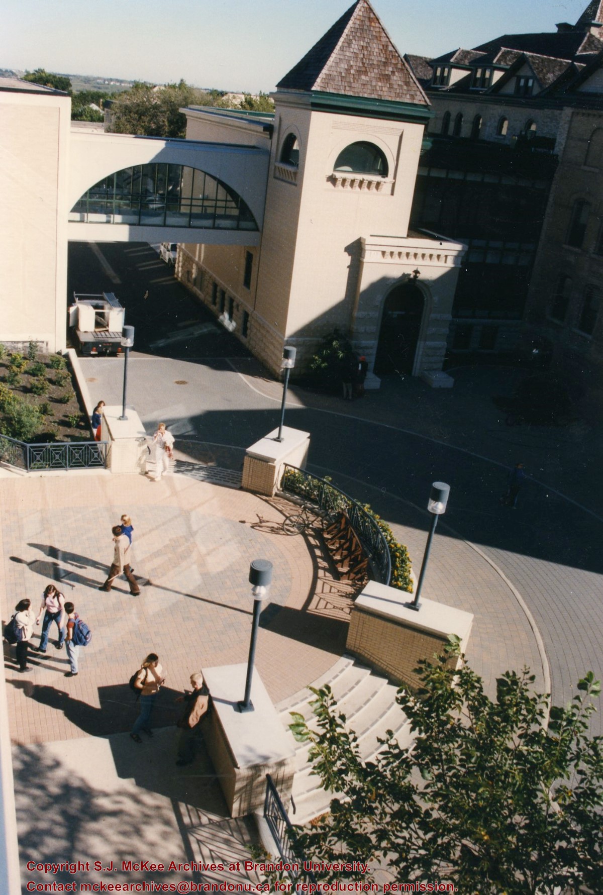
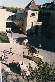
View is southwest from the corner of Clark Hall and the Clark Hall extension. Photograph shows students entering and exiting the George T. Richardson Centre and walking through the courtyard.
Images
Show Less

Brandon University campus

http://archives.brandonu.ca/en/permalink/descriptions8033
Part Of
Aerial views and campus photographs
Description Level
Item
GMD
graphic
Date Range
c. 1990s
Part Of
Aerial views and campus photographs
Description Level
Item
Series Number
2.1
Item Number
2.1.101
GMD
graphic
Date Range
c. 1990s
Physical Description
4" x 6" (colour)
Scope and Content
View is south from appromately the skywalk. Photograph shows the walkway that runs in front of the A.E. McKenzie Building south to the George T. Richardson Centre staircase and entrance. McMaster Hall in the background.
Images
Show Less

Brandon University campus

http://archives.brandonu.ca/en/permalink/descriptions8034
Part Of
Aerial views and campus photographs
Description Level
Item
GMD
graphic
Date Range
c. 2000
Part Of
Aerial views and campus photographs
Creator
Photograph: Sandy Black
Description Level
Item
Series Number
2.1
Item Number
2.1.102
GMD
graphic
Date Range
c. 2000
Physical Description
4" x 6" (colour)
Scope and Content
View is north northeast from the roof of the John E. Robbins Library in the George T. Richardson Centre. Photograph shows the entrance to the Richardson Building, part of the courtyard and the Clark Hall extension.
Images
Show Less

Brandon University campus

http://archives.brandonu.ca/en/permalink/descriptions8035
Part Of
Aerial views and campus photographs
Description Level
Item
GMD
graphic
Date Range
c. 2000
Part Of
Aerial views and campus photographs
Creator
Photographer: Sandy Black
Description Level
Item
Series Number
2.1
Item Number
2.1.103
GMD
graphic
Date Range
c. 2000
Physical Description
6" x 4" (colour)
Scope and Content
View is northeast from in front of the John E. Robbins Library in the George T. Richardson Centre. Photograph shows the entrance to the Richardson Building, most of the courtyard, Clark Hall and its extension.
Images
Show Less

20 records – page 2 of 1.