Skip header and navigation

Revise Search

10 records – page 1 of 1.

Aerial view: Brandon College from 23rd Street

http://archives.brandonu.ca/en/permalink/descriptions602
Part Of
Brandon University Photograph collection
Description Level
Item
GMD
graphic
Date Range
[1963-1966]
Part Of
Brandon University Photograph collection
Description Level
Item
Series Number
2.1
Item Number
BUPC 2.1.9
GMD
graphic
Date Range
[1963-1966]
Physical Description
5" x 4" (b/w)
Scope and Content
Image is looking east northeast from approximately the 300 block of 23rd Street between Lorne and Louise Avenues. Photograph shows the Brandon College campus after the opening of the original Music Building in 1963, but before the construction of the Education Building in 1966. A number of house on the 300 blocks of 22nd and 21st Streets are visible in the foreground, with the A.E. McKenzie Seed Co., the Prince Edward Hotel and various grain elevators on the horizon.
Subject Access
aerial photographs
campus photographs
campus buildings
Brandon streets
Grain elevators
Images
Show Less

Park Street School

http://archives.brandonu.ca/en/permalink/descriptions14316
Part Of
Brandon and Area Photograph Collection
Description Level
Item
GMD
graphic
Date Range
[after 1905]
Part Of
Brandon and Area Photograph Collection
Description Level
Item
Series Number
2
Item Number
BAPC 2.42
GMD
graphic
Date Range
[after 1905]
Physical Description
5.5" x 3.5" (color)
Material Details
Postcard
History / Biographical
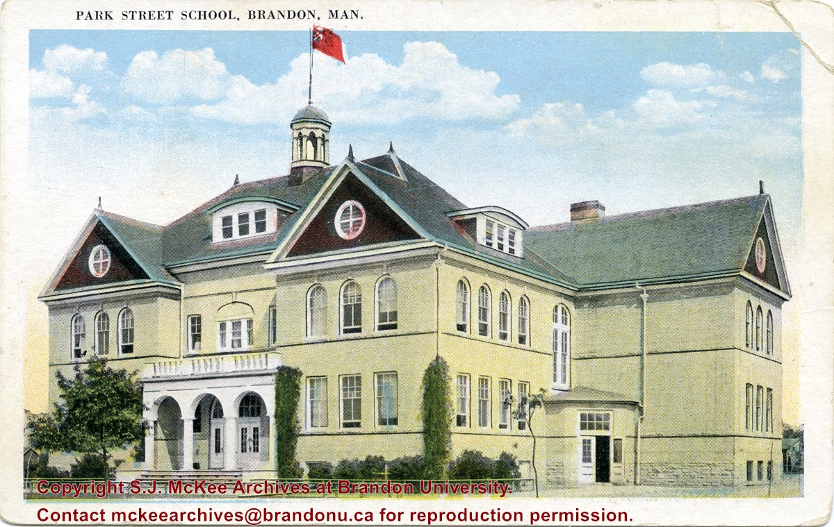
Located south of Stanley Park along the 1400 block of Lorne Avenue, Park School was constructed in 1904. Designed by W.A. Elliot and built by the Brandon Construction Company the structure measured 71 x 107 feet and cost approximately $38,000. The school featured a principal’s office, reception room, staff rooms, an assembly hall for eight hundred, and ten class rooms. The interior walls were lined with mahogany while the floors were made of western pine. The interior of the basement was constructed from Tyndall stone, while Crookston brick trimmed with Bedford stone made up the exterior. The building was razed in September 1978. Hobbes Manor was built on the location.
Scope and Content
Item is a postcard showing Park School in Brandon, MB.
Name Access
Park School
Subject Access
schools
Education
Storage Location
BAPC photograph drawer
Images
Show Less

Wheat City Business College

http://archives.brandonu.ca/en/permalink/descriptions13653
Part Of
Brandon and Area Photograph Collection
Description Level
Item
GMD
graphic
Date Range
1920
Accession Number
3-2015
Part Of
Brandon and Area Photograph Collection
Creator
Photographer: Clark J. Smith
Description Level
Item
Series Number
4
Item Number
BAPC 4.36
Accession Number
3-2015
GMD
graphic
Date Range
1920
Physical Description
12.5" x 9.5" (b/w)
Physical Condition
Some warping.
Scope and Content
Composite portrait of the Wheat City Business College class, 1920. F.A. Wood, Principal, Instructors: Mr. D.S. Forsyth; Miss. J. H. Snider; Miss. M.D. Cowan; Miss. I.E. McKewer.
Notes
Part of the Chapman Museum collection.
Name Access
Wheat City Business College
C.C. Stewart
C. Young
N. Tompkins
M. Mansfield
L. Bray
M. Atchison
E. Braybrook
M. Forsythe
W. Dunbar
E. Plaice
R.B. Dunsire
E. Sararas
W. Barr
E. Doughty
A.W. Meadows
L.S. Ling
H. Hallatt
E. Robinson
A. Dalglish
B. Cane
H. Scott
J. Machen
C.A. Stewart
A. Rogerson
W.A. Dodd
E. McMunn
N. McDonald
J. Dubbin
M. Bennett
F.W. Woodley
H. Wren
A. Chesley
A. boyd
E.A. Howell
G. Murgatroyd
E. Wallace
J. Paterson
E.E. Sararas
V. Sharp
J.S. Wood
R. Cristall
M. McAuley
J. Day
J. Scott
K.W. Beck
J. Aberdeen
M. McConnell
M. Winteringhaus
H.A. O'Neil
D.S. Forsyth
J. H. Snider
F.A. Wood
M.D. Cowan
I.E. McKewer
W. Harrison
M. Coates
H.E. Hotham
G. Gooden
R.E. Grames
K. Calladon
F.P. Burton
H. Foote
D. Wilson
N. Morris
T.A. Quigley
S. Gerry
E. Speers
E. Beatty
R. Murkle
D.H. Hunn
H. Griffith
L. Gulthorpe
E. Pugh
S. Chester
A.B. Dobbyn
L. Vaccari
Z. Bosman
P.C. Gilsthorpe
N. Goodwin
C.S. Hanford
R. Harris
C. Freedman
E. Graham
B. Campbell
R.W. Cowie
G. Roddick
E. Stone
N. Barager
P. Maxfield
M. Denise
A.B. Olive
L.G. Minions
I. Lawrence
R.H. Deans
L. Crawford
H. Hossack
R. Schwartz
B. Pottinger
M. Mains
T.C. Cunningham
M. Mattron
J.P. Connolly
D. Dixon
C. Smith
M. Buchanan
R. Hoey
E. Potter
E. Minions
D.G. Cooke
C. Timmons
A.E. Williams
E. Johns
S.C. McLeod
L. Kennedy
W.T. Lee
M. Roddick
E. Connell
B. Philip
E.E. Simmons
F. Anderson
L. Turner
B.K. Stratford
E. Hawkins
L. Simpson
A. Beatty
H.C. Edanthy
Subject Access
Education
class portraits
secondary education
Storage Location
BAPC oversize storage drawer 2
Show Less

Aerial view - Brandon University campus

http://archives.brandonu.ca/en/permalink/descriptions7989
Part Of
Brandon University Photograph collection
Description Level
Item
GMD
graphic
Date Range
c. 2000
Part Of
Brandon University Photograph collection
Creator
Photograph commissioned by Brandon University and taken by Yourview Aerial Scenics Ltd.
Description Level
Item
Series Number
2.1
Item Number
BUPC 2.1.55
GMD
graphic
Date Range
c. 2000
Physical Description
6" x 4" (colour)
Scope and Content
View is southwest from approximatley 16th Street between Princess and Rosser Avenues. Photograph shows the Brandon University campus, as well as surrounding residential blocks, including Flemming, J.R. Reid and Vincent Massey schools.
Subject Access
aerial photographs
campus photographs
campus buildings
Brandon streets
Images
Show Less

Aerial view - Brandon University campus

http://archives.brandonu.ca/en/permalink/descriptions7990
Part Of
Brandon University Photograph collection
Description Level
Item
GMD
graphic
Date Range
c. 2000
Part Of
Brandon University Photograph collection
Creator
Photograph commissioned by Brandon University and taken by Yourview Aerial Scenics Ltd.
Description Level
Item
Series Number
2.1
Item Number
BUPC 2.1.56
GMD
graphic
Date Range
c. 2000
Physical Description
6" x 4" (colour)
Scope and Content
View is west southwest from approximatley 16th Street between Princess and Lorne Avenues. Photograph shows the Brandon University campus, as well as surrounding residential blocks between 16th and 23rd Streets, Princess and Louise Avenues..
Subject Access
aerial photographs
campus photographs
campus buildings
Brandon streets
Images
Show Less

Aerial view - Brandon University campus

http://archives.brandonu.ca/en/permalink/descriptions7991
Part Of
Brandon University Photograph collection
Description Level
Item
GMD
graphic
Date Range
c. 2000
Part Of
Brandon University Photograph collection
Creator
Photograph commissioned by Brandon University and taken by Yourview Aerial Scenics Ltd.
Description Level
Item
Series Number
2.1
Item Number
BUPC 2.1.57
GMD
graphic
Date Range
c. 2000
Physical Description
6" x 4" (colour)
Scope and Content
View is west from approximatley 17th Street between Lorne and Louise Avenues. Photograph shows a portion of the Brandon University campus (excluding the Education Building and anything north of it), as well as surrounding residential blocks from approximatley 17th Street to 22nd Street.
Subject Access
aerial photographs
campus photographs
campus buildings
Brandon streets
Images
Show Less

Aerial view - Brandon University campus

http://archives.brandonu.ca/en/permalink/descriptions7992
Part Of
Brandon University Photograph collection
Description Level
Item
GMD
graphic
Date Range
c. 1990
Part Of
Brandon University Photograph collection
Description Level
Item
Series Number
2.1
Item Number
BUPC 2.1.58
GMD
graphic
Date Range
c. 1990
Physical Description
5" x 3.5" (colour)
Scope and Content
View is west northwest from approximatley 16th Street and Louise Avenue. Photograph shows the Brandon University campus, prior to the Library Extension, and a large portion of the city to the west of the campus.
Subject Access
aerial photographs
campus photographs
campus buildings
Brandon streets
Images
Show Less

Aerial view - Brandon University campus

http://archives.brandonu.ca/en/permalink/descriptions7993
Part Of
Brandon University Photograph collection
Description Level
Item
GMD
graphic
Date Range
c. 1990
Part Of
Brandon University Photograph collection
Description Level
Item
Series Number
2.1
Item Number
BUPC 2.1.59
GMD
graphic
Date Range
c. 1990
Physical Description
5" x 3.5" (colour)
Scope and Content
View is northwest from approximatley 16th Street and Louise Avenue. Photograph shows the Brandon University campus, prior to the Library Extension, and a large portion of the city to the west of the campus.
Subject Access
aerial photographs
campus photographs
campus buildings
Brandon streets
Show Less

Aerial view: Brandon College

http://archives.brandonu.ca/en/permalink/descriptions594
Part Of
Brandon University Photograph collection
Description Level
Item
GMD
graphic
Date Range
[fall 1964?]
Part Of
Brandon University Photograph collection
Description Level
Item
Series Number
2.1
Item Number
BUPC 2.1.2
GMD
graphic
Date Range
[fall 1964?]
Physical Description
5" x 4" (b/w)
Scope and Content
Brandon College looking south from 19th Street. Photograph was taken after Flora Cowan Hall was built but before construction of the Education Building.
Subject Access
aerial photographs
campus photographs
campus buildings
Brandon streets
Images
Show Less

Aerial view - Brandon College looking southwest

http://archives.brandonu.ca/en/permalink/descriptions601
Part Of
Brandon University Photograph collection
Description Level
Item
GMD
graphic
Date Range
[1963-1966]
Part Of
Brandon University Photograph collection
Description Level
Item
Series Number
2.1
Item Number
BUPC 2.1.8
GMD
graphic
Date Range
[1963-1966]
Physical Description
5" x 4" (b/w)
Scope and Content
Image shows the Brandon College campus from 17th Street looking southwest. The photo was taken after the completion of the original Music Building in 1963, but construction of the Education Building. Also visible are a number of properties on the 200 block of 18th Street and the 200 block of 20th Street.
Subject Access
aerial photographs
campus photographs
campus buildings
Brandon streets
Images
Show Less

10 records – page 1 of 1.