Skip header and navigation

Revise Search

20 records – page 1 of 1.

Front Street, west end of Baldur, MB

http://archives.brandonu.ca/en/permalink/descriptions14405
Part Of
James Wall collection
Description Level
Item
GMD
graphic
Date Range
[1900-1904]
Accession Number
12-2004
Part Of
James Wall collection
Description Level
Item
Series Number
Box 2
Item Number
12-2004.12
Accession Number
12-2004
GMD
graphic
Date Range
[1900-1904]
Physical Description
6.6" x 4.75" (b/w)
Material Details
On matting (9" x 7")
Custodial History
See collection level description for the James Douglas Wall collection.
Scope and Content
Image of the west end of Front Street in Baldur, MB. Business and buildings in the photo include (L-R): Cleghorn's drug store, Fowlers, Tom Johnson's John Deer Shop, barber shop, Royal Bank (Odd Fellows Hall upstairs), Lee's Chinese Cafe, Hunters Hardware, Folwer Block, L. Curtis Block, Sexsmith Block - boarding house and sample room.
Subject Access
rural images
Storage Location
2004 accessions
Images
Show Less

Aerial view: Brandon College from 23rd Street

http://archives.brandonu.ca/en/permalink/descriptions602
Part Of
Brandon University Photograph collection
Description Level
Item
GMD
graphic
Date Range
[1963-1966]
Part Of
Brandon University Photograph collection
Description Level
Item
Series Number
2.1
Item Number
BUPC 2.1.9
GMD
graphic
Date Range
[1963-1966]
Physical Description
5" x 4" (b/w)
Scope and Content
Image is looking east northeast from approximately the 300 block of 23rd Street between Lorne and Louise Avenues. Photograph shows the Brandon College campus after the opening of the original Music Building in 1963, but before the construction of the Education Building in 1966. A number of house on the 300 blocks of 22nd and 21st Streets are visible in the foreground, with the A.E. McKenzie Seed Co., the Prince Edward Hotel and various grain elevators on the horizon.
Subject Access
aerial photographs
campus photographs
campus buildings
Brandon streets
Grain elevators
Images
Show Less

MPE A 100 Sperling

http://archives.brandonu.ca/en/permalink/descriptions8370
Part Of
RG 4 Manitoba Pool Elevator fonds
Description Level
Sub-series
GMD
textual records
Date Range
1926-72
Part Of
RG 4 Manitoba Pool Elevator fonds
Description Level
Sub-series
Series Number
MPE A
Item Number
100
GMD
textual records
Date Range
1926-72
Physical Description
13 cm
Custodial History
Sperling Co-operative Elevator Association Limited Organizational papers: 1926 - 1954 Memorandum of Association Meeting - Bylaws No. 1 - 7 Agreement between SCE-MPE Agreement between SCE-MPE Agreement between SCE-MPE Minutes of Executive Board meetings, volume 1, October 19,1926 - volume 8, November 20, 1972 Minutes of Shareholders Annual Meetings, 1966 (1 report) Financial Records and Statistics Analysis of operating results, 1951 - 1963 (8 reports) Statement of surplus, 1952 - 1955 (2 reports) Auditors report, 1927 - 1969 (16 reports) Detail of grain earnings, 1964 - 1971 (7 reports) Review of operating results, 1961 - 1966 (2 reports) Statement and demand for taxes, 1973 Costs of Sperling dwelling, January, 1953 Statement of Taxes, 1953 Receipts, 1952 - 1960 (12 reports) Correspondence - 1952 - 1974 Membership lists, 1969 Miscellaneous Directors' attendance list, 1972 (1 report) List of Directors, 1926 - 1964 (6 reports)
Show Less

North side of the A.E. McKenzie Building

http://archives.brandonu.ca/en/permalink/descriptions770
Part Of
Brandon University Photograph collection
Description Level
Item
GMD
graphic
Date Range
c. mid 1980s
Part Of
Brandon University Photograph collection
Description Level
Item
Series Number
2.4
Item Number
BUPC 2.4.3
GMD
graphic
Date Range
c. mid 1980s
Physical Description
3.5" x 5" (colour)
Scope and Content
Photograph is looking southwest from in front of the Original Music Building and shows the north side of the A.E. McKenzie Building and the west side of the Queen Elizabeth II Music Building (including the link). A number of cars in the parking lot are also visible.
Images
Show Less

East side of the A.E. McKeznie Building

http://archives.brandonu.ca/en/permalink/descriptions861
Part Of
Brandon University Photograph collection
Description Level
Item
GMD
graphic
Date Range
c .1985
Part Of
Brandon University Photograph collection
Description Level
Item
Series Number
2.4
Item Number
BUPC 2.4.1
GMD
graphic
Date Range
c .1985
Physical Description
3.5" x 5" (colour)
Scope and Content
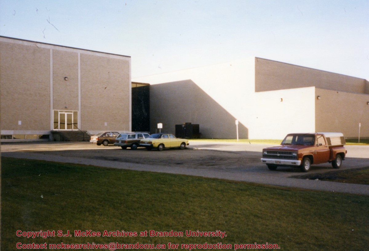
Photograph is looking west from the sidewalk between Clark Hall and the Education Building and shows the east side of the A.E. McKenzie Building as well as a trailer that housed the Canada Manpower office (career councelling) in the 1960s. The trailer was later moved near the Kinsmen Stadium where it housed the Quill office.
Images
Show Less

Aerial view - Brandon University campus

http://archives.brandonu.ca/en/permalink/descriptions7989
Part Of
Brandon University Photograph collection
Description Level
Item
GMD
graphic
Date Range
c. 2000
Part Of
Brandon University Photograph collection
Creator
Photograph commissioned by Brandon University and taken by Yourview Aerial Scenics Ltd.
Description Level
Item
Series Number
2.1
Item Number
BUPC 2.1.55
GMD
graphic
Date Range
c. 2000
Physical Description
6" x 4" (colour)
Scope and Content
View is southwest from approximatley 16th Street between Princess and Rosser Avenues. Photograph shows the Brandon University campus, as well as surrounding residential blocks, including Flemming, J.R. Reid and Vincent Massey schools.
Subject Access
aerial photographs
campus photographs
campus buildings
Brandon streets
Images
Show Less

Aerial view - Brandon University campus

http://archives.brandonu.ca/en/permalink/descriptions7990
Part Of
Brandon University Photograph collection
Description Level
Item
GMD
graphic
Date Range
c. 2000
Part Of
Brandon University Photograph collection
Creator
Photograph commissioned by Brandon University and taken by Yourview Aerial Scenics Ltd.
Description Level
Item
Series Number
2.1
Item Number
BUPC 2.1.56
GMD
graphic
Date Range
c. 2000
Physical Description
6" x 4" (colour)
Scope and Content
View is west southwest from approximatley 16th Street between Princess and Lorne Avenues. Photograph shows the Brandon University campus, as well as surrounding residential blocks between 16th and 23rd Streets, Princess and Louise Avenues..
Subject Access
aerial photographs
campus photographs
campus buildings
Brandon streets
Images
Show Less

Aerial view - Brandon University campus

http://archives.brandonu.ca/en/permalink/descriptions7991
Part Of
Brandon University Photograph collection
Description Level
Item
GMD
graphic
Date Range
c. 2000
Part Of
Brandon University Photograph collection
Creator
Photograph commissioned by Brandon University and taken by Yourview Aerial Scenics Ltd.
Description Level
Item
Series Number
2.1
Item Number
BUPC 2.1.57
GMD
graphic
Date Range
c. 2000
Physical Description
6" x 4" (colour)
Scope and Content
View is west from approximatley 17th Street between Lorne and Louise Avenues. Photograph shows a portion of the Brandon University campus (excluding the Education Building and anything north of it), as well as surrounding residential blocks from approximatley 17th Street to 22nd Street.
Subject Access
aerial photographs
campus photographs
campus buildings
Brandon streets
Images
Show Less

Aerial view - Brandon University campus

http://archives.brandonu.ca/en/permalink/descriptions7992
Part Of
Brandon University Photograph collection
Description Level
Item
GMD
graphic
Date Range
c. 1990
Part Of
Brandon University Photograph collection
Description Level
Item
Series Number
2.1
Item Number
BUPC 2.1.58
GMD
graphic
Date Range
c. 1990
Physical Description
5" x 3.5" (colour)
Scope and Content
View is west northwest from approximatley 16th Street and Louise Avenue. Photograph shows the Brandon University campus, prior to the Library Extension, and a large portion of the city to the west of the campus.
Subject Access
aerial photographs
campus photographs
campus buildings
Brandon streets
Images
Show Less

Aerial view - Brandon University campus

http://archives.brandonu.ca/en/permalink/descriptions7993
Part Of
Brandon University Photograph collection
Description Level
Item
GMD
graphic
Date Range
c. 1990
Part Of
Brandon University Photograph collection
Description Level
Item
Series Number
2.1
Item Number
BUPC 2.1.59
GMD
graphic
Date Range
c. 1990
Physical Description
5" x 3.5" (colour)
Scope and Content
View is northwest from approximatley 16th Street and Louise Avenue. Photograph shows the Brandon University campus, prior to the Library Extension, and a large portion of the city to the west of the campus.
Subject Access
aerial photographs
campus photographs
campus buildings
Brandon streets
Show Less

Brandon University campus construction

http://archives.brandonu.ca/en/permalink/descriptions8005
Part Of
Brandon University Photograph collection
Description Level
Item
GMD
graphic
Date Range
c. 1996
Part Of
Brandon University Photograph collection
Creator
Photographer: Sandy Black
Description Level
Item
Series Number
2.1
Item Number
BUPC 2.1.71
GMD
graphic
Date Range
c. 1996
Physical Description
4" x 6" (colour)
Scope and Content
View is northeast probably from the roof of McMaster Hall. Photograph shows the construction of the new roof on Clark Hall and the Brandon College Building. A portion of the east side of the 000 and 100 blocks of 18th Street, as well as the corner of 18th Street and Rosser Avenue are visible in the upper left hand corner. This includes the "Downtown Brandon" sign.
Subject Access
campus photographs
campus buildings
campus construction
Brandon streets
Images
Show Less

Brandon University campus construction

http://archives.brandonu.ca/en/permalink/descriptions8006
Part Of
Brandon University Photograph collection
Description Level
Item
GMD
graphic
Date Range
c. 1996
Part Of
Brandon University Photograph collection
Creator
Photographer: Sandy Black
Description Level
Item
Series Number
2.1
Item Number
BUPC 2.1.72
GMD
graphic
Date Range
c. 1996
Physical Description
6" x 4" (colour)
Scope and Content
View is north northeast probably from the roof of McMaster Hall. Photograph shows the construction of the new roof on Clark Hall and the Brandon College Building, as well as the construction of the extension to Clark Hall and the skywalk. Portions of the city as far north as the Assiniboine River are also visible.
Subject Access
campus photographs
campus buildings
campus construction
Brandon streets
Images
Show Less

Brandon University campus construction

http://archives.brandonu.ca/en/permalink/descriptions8018
Part Of
Brandon University Photograph collection
Description Level
Item
GMD
graphic
Date Range
c. 1996
Part Of
Brandon University Photograph collection
Description Level
Item
Series Number
2.1
Item Number
BUPC 2.1.84
GMD
graphic
Date Range
c. 1996
Physical Description
6" x 4" (colour)
Scope and Content
View is north northeast from the roof of McMaster Hall. Photograph shows the campus under construction during the renovation of the Brandon College Building and Clark Hall. The photograph was taken in late fall after the roof had been removed from the buildings but before the construction of the extension of Clark Hall. Construction materials litter the courtyard and driveway. The view looking north extends to The North Hill - a number of residential blocks, particularly to the northeast of 18th Street are visible. Buildings include the International Harvester Building and Kin Village.
Subject Access
campus photographs
campus buildings
campus construction
Brandon streets
Images
Show Less

Brandon University campus construction

http://archives.brandonu.ca/en/permalink/descriptions8020
Part Of
Brandon University Photograph collection
Description Level
Item
GMD
graphic
Date Range
c. 1996
Part Of
Brandon University Photograph collection
Creator
Photographer: Sandy Black
Description Level
Item
Series Number
2.1
Item Number
BUPC 2.1.86
GMD
graphic
Date Range
c. 1996
Physical Description
6" x 4" (colour)
Scope and Content
View is north northeast probably from the roof of McMaster Hall. Photograph shows the construction of the new roof on Clark Hall and the Brandon College Building, as well as the construction of the extension to Clark Hall and the skywalk. The view looking north extends to The North Hill - a number of residential blocks, particularly to the northeast of 18th Street are visible. Buildings include the International Harvester Building and Kin Village.
Subject Access
campus photographs
campus buildings
campus construction
Brandon streets
Images
Show Less

Aerial view: Brandon College

http://archives.brandonu.ca/en/permalink/descriptions594
Part Of
Brandon University Photograph collection
Description Level
Item
GMD
graphic
Date Range
[fall 1964?]
Part Of
Brandon University Photograph collection
Description Level
Item
Series Number
2.1
Item Number
BUPC 2.1.2
GMD
graphic
Date Range
[fall 1964?]
Physical Description
5" x 4" (b/w)
Scope and Content
Brandon College looking south from 19th Street. Photograph was taken after Flora Cowan Hall was built but before construction of the Education Building.
Subject Access
aerial photographs
campus photographs
campus buildings
Brandon streets
Images
Show Less

Aerial view - Brandon College looking southwest

http://archives.brandonu.ca/en/permalink/descriptions601
Part Of
Brandon University Photograph collection
Description Level
Item
GMD
graphic
Date Range
[1963-1966]
Part Of
Brandon University Photograph collection
Description Level
Item
Series Number
2.1
Item Number
BUPC 2.1.8
GMD
graphic
Date Range
[1963-1966]
Physical Description
5" x 4" (b/w)
Scope and Content
Image shows the Brandon College campus from 17th Street looking southwest. The photo was taken after the completion of the original Music Building in 1963, but construction of the Education Building. Also visible are a number of properties on the 200 block of 18th Street and the 200 block of 20th Street.
Subject Access
aerial photographs
campus photographs
campus buildings
Brandon streets
Images
Show Less

Farmer in a business suit

http://archives.brandonu.ca/en/permalink/specialcollections156
Part Of
RG 4 Manitoba Pool Elevator fonds
Description Level
Item
Date Range
c1957
Part Of
RG 4 Manitoba Pool Elevator fonds
Collection
Manitoba Pool Elevator Library Collection
Creator
Davis, John Herbert, 1904
Hinshaw, Kenneth
Description Level
Item
Item Number
Archives 14-4-21
Item Number Range
Archives 14-4-21
Responsibility
John H. Davis and Kenneth Hinshaw
Start Date
c1957
Date Range
c1957
Publication
New York : Simon and Schuster
Physical Description
241 p. ; 22 cm
Subject Access
Agriculture Economic aspects United States
Storage Location
Box 4-Historical I
Storage Range
Box 4-Historical I
Show Less

Ways farmers do business

http://archives.brandonu.ca/en/permalink/specialcollections357
Part Of
RG 4 Manitoba Pool Elevator fonds
Description Level
Item
Date Range
1966
Part Of
RG 4 Manitoba Pool Elevator fonds
Collection
Manitoba Pool Elevator Library Collection
Creator
LeBeau, Oscar Ray, 1902
Angevine, David W
Farmer Cooperative Services, U.S. Deaprtment of Agriculture
Description Level
Item
Item Number
Archives 14-23-32
Item Number Range
Archives 14-23-32
Responsibility
by Oscar R. LeBeau
Start Date
1966
Date Range
1966
Publication
Washington, D. C. : Farmer Cooperative Service, U.S. Department of Agriculture
Publisher Series
Educational aid ; 8
Physical Description
12 p. ; 23 cm
Notes
Cover title
Subject Access
Cooperation
Storage Location
Box 23 - Historical VI
Storage Range
Box 23 - Historical VI
Show Less

Farmer cooperatives ... : Farm business tools

http://archives.brandonu.ca/en/permalink/specialcollections356
Part Of
RG 4 Manitoba Pool Elevator fonds
Description Level
Item
Date Range
1964
Part Of
RG 4 Manitoba Pool Elevator fonds
Collection
Manitoba Pool Elevator Library Collection
Creator
Stanton, Beryle
Farmer Cooperative Services, U.S. Deaprtment of Agriculture
Description Level
Item
Item Number
Archives 14-23-29
Item Number Range
Archives 14-23-29
Responsibility
by Beryle Stanton
Start Date
1964
Date Range
1964
Publication
Washington, D. C. : Farmer Cooperative Service, U.S. Department of Agriculture
Publisher Series
Agricultural information bulletin ; 275
Physical Description
ii, 58 p. : ill. ; 23 cm
Notes
Cover title
Subject Access
Cooperation
Storage Location
Box 23 - Historical VI
Storage Range
Box 23 - Historical VI
Show Less

A.E. McKenzie Building construction

http://archives.brandonu.ca/en/permalink/descriptions627
Part Of
Brandon University Photograph collection
Description Level
Item
GMD
graphic
Date Range
[1959-1960]
Part Of
Brandon University Photograph collection
Description Level
Item
Series Number
2.4
Item Number
BUPC 2.4.6
GMD
graphic
Date Range
[1959-1960]
Physical Description
5" x 7" (b/w)
Scope and Content
Photograph is looking northeast (?) and shows the construction of the A.E. McKenzie Building (Library and Arts Building) during the winter.
Subject Access
campus buildings
Images
Show Less

20 records – page 1 of 1.