Skip header and navigation

Revise Search

20 records – page 1 of 1.

East side of the A.E. McKeznie Building

http://archives.brandonu.ca/en/permalink/descriptions861
Part Of
Brandon University Photograph collection
Description Level
Item
GMD
graphic
Date Range
c .1985
Part Of
Brandon University Photograph collection
Description Level
Item
Series Number
2.4
Item Number
BUPC 2.4.1
GMD
graphic
Date Range
c .1985
Physical Description
3.5" x 5" (colour)
Scope and Content
Photograph is looking west from the sidewalk between Clark Hall and the Education Building and shows the east side of the A.E. McKenzie Building as well as a trailer that housed the Canada Manpower office (career councelling) in the 1960s. The trailer was later moved near the Kinsmen Stadium where it housed the Quill office.
Images
Show Less

Aerial view: Brandon College from 23rd Street

http://archives.brandonu.ca/en/permalink/descriptions602
Part Of
Brandon University Photograph collection
Description Level
Item
GMD
graphic
Date Range
[1963-1966]
Part Of
Brandon University Photograph collection
Description Level
Item
Series Number
2.1
Item Number
BUPC 2.1.9
GMD
graphic
Date Range
[1963-1966]
Physical Description
5" x 4" (b/w)
Scope and Content
Image is looking east northeast from approximately the 300 block of 23rd Street between Lorne and Louise Avenues. Photograph shows the Brandon College campus after the opening of the original Music Building in 1963, but before the construction of the Education Building in 1966. A number of house on the 300 blocks of 22nd and 21st Streets are visible in the foreground, with the A.E. McKenzie Seed Co., the Prince Edward Hotel and various grain elevators on the horizon.
Subject Access
aerial photographs
campus photographs
campus buildings
Brandon streets
Grain elevators
Images
Show Less

Laurie East interview

http://archives.brandonu.ca/en/permalink/descriptions14456
Part Of
Westman Oral History collection
Description Level
Item
GMD
sound recordings
Date Range
December 4, 1981
Accession Number
35-1998
Interview Date: 1981-12-04 Narrator (Interviewee): Laurie East Interviewer: Mrs. Mae
  1 audio     1 document  
Part Of
Westman Oral History collection
Description Level
Item
Item Number
OH044.Eas
Accession Number
35-1998
GMD
sound recordings
Date Range
December 4, 1981
Physical Description
1 audio cassette [00:09:15]
History / Biographical
Laurence Overton "Laurie" East was born in the municipality of Odanah on the west half of 29-13-18, on March 13, 1911. He attended Tremaine and Roseneath schools and worked on the family farm, eventually leaving school to work due to his father's ill health and then taking over the operation in 1936, after his father died. Laurie retired from farming in 1976. Laurie married Bernice McDonald (1916-2006), a teacher, on July 4, 1942. They had no children. Laurie's hobbies were music, dancing and travel; he took part in local entertainment and taught square dancing classes. He was a member of the Hunterville United Church, serving on the board and volunteering as Sunday School Superintendent or teacher. In the 1940s, Laurie was part of local commmittees to secure telephone and postal service. From 1970-1983, he was a member of Elton Municipal Council. Shortly after joining the council, Laurie was appointed as a representive to the library board; he joined representatives from Minnedosa and Minto councils, as there was support in the region for the organization and establishment of a regional library. Laurie East died on April 18, 2003 in Brandon, MB and is buried at the Rapid City Cemetery.
Custodial History
As part of the Westman Oral History Collection, this collection was accessioned by the McKee Archives in 1998. The original tapes from the Westman Oral History project were deposited in the Brandon Public Library. Copies of these originals were made by Margaret Pollex of the Brandon University Language Lab at the request of Eileen McFadden, University Archivist in the early 1990s. These copies compose the collection held in the McKee Archives.
Scope and Content
Item is an audiocassette tape containing an interview with Laurie East about the Minnedosa Regional Library. Interviewer is Mae Johnson.
Notes
History/bio information from the records and East's obituary. Transcript by Simon Richard (2020). Description by Christy Henry.
Language Note
English
Audio Tracks
Documents

OH044_East_transcript.pdf

Read PDF Download PDF
Show Less

North side of the A.E. McKenzie Building

http://archives.brandonu.ca/en/permalink/descriptions770
Part Of
Brandon University Photograph collection
Description Level
Item
GMD
graphic
Date Range
c. mid 1980s
Part Of
Brandon University Photograph collection
Description Level
Item
Series Number
2.4
Item Number
BUPC 2.4.3
GMD
graphic
Date Range
c. mid 1980s
Physical Description
3.5" x 5" (colour)
Scope and Content
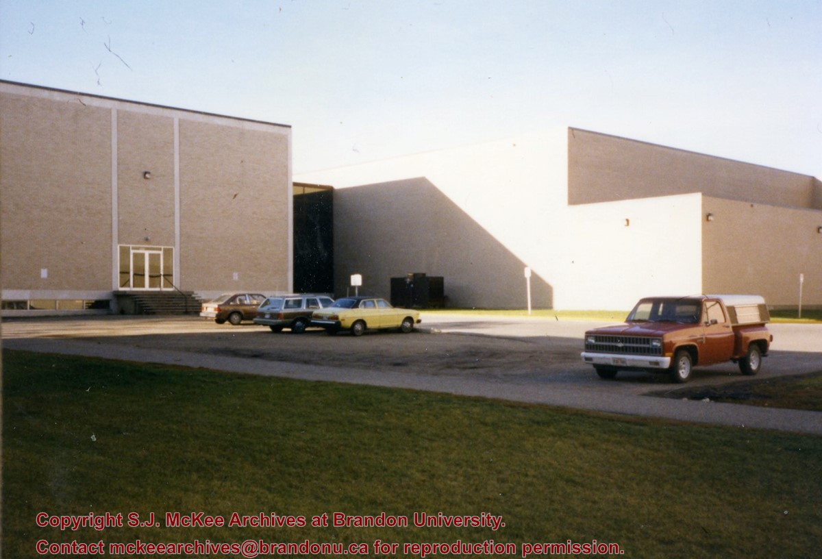
Photograph is looking southwest from in front of the Original Music Building and shows the north side of the A.E. McKenzie Building and the west side of the Queen Elizabeth II Music Building (including the link). A number of cars in the parking lot are also visible.
Images
Show Less

Bernice C. East interview

http://archives.brandonu.ca/en/permalink/descriptions14528
Part Of
Westman Oral History collection
Description Level
Item
GMD
sound recordings
Date Range
December 4, 1981
Accession Number
35-1998
Part Of
Westman Oral History collection
Description Level
Item
Item Number
OH045.Eas
Accession Number
35-1998
GMD
sound recordings
Date Range
December 4, 1981
Physical Description
1 audio cassette [00:25:00]
History / Biographical
Berncie Caroline East (nee McDonald) was born on August 30, 1914 at Brookdale, MB in the RM of North Cypress. She attended Brookdale school, Brandon Collegiate Institute (BCI) and the Winnipeg Normal School. Her BA was achieved by corresondence and night classes from the University of Manitoba in 1963. As a teacher, Bernice taught at Tremaine, Brookdale, Minnedosa and Elton. Bernice married Laurence Overton East (1911-2003) on July 4, 1942. They did not have any children. The couple farmed in the Hunterville district until Laurie retired in 1976. They moved to Brandon in 1992. Bernice loved the oudoors and gardening, as well as square dancing and music. For a number of years, Bernice and Laurie kept a Bluebird line. The couple also enjoyed travel. Bernice was also active and supportive in community affairs, spending time as a Director on the Manitoba Agricultural Hall of Fame Board. Bernice East died on April 13, 2006 in Brandon, MB. She is buried at Rapid City Cemetery.
Custodial History
As part of the Westman Oral History Collection, this collection was accessioned by the McKee Archives in 1998. The original tapes from the Westman Oral History project were deposited in the Brandon Public Library. Copies of these originals were made by Margaret Pollex of the Brandon University Language Lab at the request of Eileen McFadden, University Archivist in the early 1990s. These copies compose the collection held in the McKee Archives.
Scope and Content
Item is an audiocassette tape containing an interview with Bernice East about aspects of education in Odanah Municipality, 1880-1981. Interviewer is Mae Johnson.
Notes
History/bio information from the records and East's obituary. Description by Christy Henry.
Language Note
English
Related Material
OH044 Lawrie O. East
Audio Tracks
Show Less

Aerial view: Brandon College

http://archives.brandonu.ca/en/permalink/descriptions594
Part Of
Brandon University Photograph collection
Description Level
Item
GMD
graphic
Date Range
[fall 1964?]
Part Of
Brandon University Photograph collection
Description Level
Item
Series Number
2.1
Item Number
BUPC 2.1.2
GMD
graphic
Date Range
[fall 1964?]
Physical Description
5" x 4" (b/w)
Scope and Content
Brandon College looking south from 19th Street. Photograph was taken after Flora Cowan Hall was built but before construction of the Education Building.
Subject Access
aerial photographs
campus photographs
campus buildings
Brandon streets
Images
Show Less

Aerial view - Brandon College looking southwest

http://archives.brandonu.ca/en/permalink/descriptions601
Part Of
Brandon University Photograph collection
Description Level
Item
GMD
graphic
Date Range
[1963-1966]
Part Of
Brandon University Photograph collection
Description Level
Item
Series Number
2.1
Item Number
BUPC 2.1.8
GMD
graphic
Date Range
[1963-1966]
Physical Description
5" x 4" (b/w)
Scope and Content
Image shows the Brandon College campus from 17th Street looking southwest. The photo was taken after the completion of the original Music Building in 1963, but construction of the Education Building. Also visible are a number of properties on the 200 block of 18th Street and the 200 block of 20th Street.
Subject Access
aerial photographs
campus photographs
campus buildings
Brandon streets
Images
Show Less

Aerial view - Brandon University campus

http://archives.brandonu.ca/en/permalink/descriptions7989
Part Of
Brandon University Photograph collection
Description Level
Item
GMD
graphic
Date Range
c. 2000
Part Of
Brandon University Photograph collection
Creator
Photograph commissioned by Brandon University and taken by Yourview Aerial Scenics Ltd.
Description Level
Item
Series Number
2.1
Item Number
BUPC 2.1.55
GMD
graphic
Date Range
c. 2000
Physical Description
6" x 4" (colour)
Scope and Content
View is southwest from approximatley 16th Street between Princess and Rosser Avenues. Photograph shows the Brandon University campus, as well as surrounding residential blocks, including Flemming, J.R. Reid and Vincent Massey schools.
Subject Access
aerial photographs
campus photographs
campus buildings
Brandon streets
Images
Show Less

Aerial view - Brandon University campus

http://archives.brandonu.ca/en/permalink/descriptions7990
Part Of
Brandon University Photograph collection
Description Level
Item
GMD
graphic
Date Range
c. 2000
Part Of
Brandon University Photograph collection
Creator
Photograph commissioned by Brandon University and taken by Yourview Aerial Scenics Ltd.
Description Level
Item
Series Number
2.1
Item Number
BUPC 2.1.56
GMD
graphic
Date Range
c. 2000
Physical Description
6" x 4" (colour)
Scope and Content
View is west southwest from approximatley 16th Street between Princess and Lorne Avenues. Photograph shows the Brandon University campus, as well as surrounding residential blocks between 16th and 23rd Streets, Princess and Louise Avenues..
Subject Access
aerial photographs
campus photographs
campus buildings
Brandon streets
Images
Show Less

Aerial view - Brandon University campus

http://archives.brandonu.ca/en/permalink/descriptions7991
Part Of
Brandon University Photograph collection
Description Level
Item
GMD
graphic
Date Range
c. 2000
Part Of
Brandon University Photograph collection
Creator
Photograph commissioned by Brandon University and taken by Yourview Aerial Scenics Ltd.
Description Level
Item
Series Number
2.1
Item Number
BUPC 2.1.57
GMD
graphic
Date Range
c. 2000
Physical Description
6" x 4" (colour)
Scope and Content
View is west from approximatley 17th Street between Lorne and Louise Avenues. Photograph shows a portion of the Brandon University campus (excluding the Education Building and anything north of it), as well as surrounding residential blocks from approximatley 17th Street to 22nd Street.
Subject Access
aerial photographs
campus photographs
campus buildings
Brandon streets
Images
Show Less

Aerial view - Brandon University campus

http://archives.brandonu.ca/en/permalink/descriptions7992
Part Of
Brandon University Photograph collection
Description Level
Item
GMD
graphic
Date Range
c. 1990
Part Of
Brandon University Photograph collection
Description Level
Item
Series Number
2.1
Item Number
BUPC 2.1.58
GMD
graphic
Date Range
c. 1990
Physical Description
5" x 3.5" (colour)
Scope and Content
View is west northwest from approximatley 16th Street and Louise Avenue. Photograph shows the Brandon University campus, prior to the Library Extension, and a large portion of the city to the west of the campus.
Subject Access
aerial photographs
campus photographs
campus buildings
Brandon streets
Images
Show Less

Aerial view - Brandon University campus

http://archives.brandonu.ca/en/permalink/descriptions7993
Part Of
Brandon University Photograph collection
Description Level
Item
GMD
graphic
Date Range
c. 1990
Part Of
Brandon University Photograph collection
Description Level
Item
Series Number
2.1
Item Number
BUPC 2.1.59
GMD
graphic
Date Range
c. 1990
Physical Description
5" x 3.5" (colour)
Scope and Content
View is northwest from approximatley 16th Street and Louise Avenue. Photograph shows the Brandon University campus, prior to the Library Extension, and a large portion of the city to the west of the campus.
Subject Access
aerial photographs
campus photographs
campus buildings
Brandon streets
Show Less

Brandon University campus construction

http://archives.brandonu.ca/en/permalink/descriptions8005
Part Of
Brandon University Photograph collection
Description Level
Item
GMD
graphic
Date Range
c. 1996
Part Of
Brandon University Photograph collection
Creator
Photographer: Sandy Black
Description Level
Item
Series Number
2.1
Item Number
BUPC 2.1.71
GMD
graphic
Date Range
c. 1996
Physical Description
4" x 6" (colour)
Scope and Content
View is northeast probably from the roof of McMaster Hall. Photograph shows the construction of the new roof on Clark Hall and the Brandon College Building. A portion of the east side of the 000 and 100 blocks of 18th Street, as well as the corner of 18th Street and Rosser Avenue are visible in the upper left hand corner. This includes the "Downtown Brandon" sign.
Subject Access
campus photographs
campus buildings
campus construction
Brandon streets
Images
Show Less

Brandon University campus construction

http://archives.brandonu.ca/en/permalink/descriptions8006
Part Of
Brandon University Photograph collection
Description Level
Item
GMD
graphic
Date Range
c. 1996
Part Of
Brandon University Photograph collection
Creator
Photographer: Sandy Black
Description Level
Item
Series Number
2.1
Item Number
BUPC 2.1.72
GMD
graphic
Date Range
c. 1996
Physical Description
6" x 4" (colour)
Scope and Content
View is north northeast probably from the roof of McMaster Hall. Photograph shows the construction of the new roof on Clark Hall and the Brandon College Building, as well as the construction of the extension to Clark Hall and the skywalk. Portions of the city as far north as the Assiniboine River are also visible.
Subject Access
campus photographs
campus buildings
campus construction
Brandon streets
Images
Show Less

Brandon University campus construction

http://archives.brandonu.ca/en/permalink/descriptions8018
Part Of
Brandon University Photograph collection
Description Level
Item
GMD
graphic
Date Range
c. 1996
Part Of
Brandon University Photograph collection
Description Level
Item
Series Number
2.1
Item Number
BUPC 2.1.84
GMD
graphic
Date Range
c. 1996
Physical Description
6" x 4" (colour)
Scope and Content
View is north northeast from the roof of McMaster Hall. Photograph shows the campus under construction during the renovation of the Brandon College Building and Clark Hall. The photograph was taken in late fall after the roof had been removed from the buildings but before the construction of the extension of Clark Hall. Construction materials litter the courtyard and driveway. The view looking north extends to The North Hill - a number of residential blocks, particularly to the northeast of 18th Street are visible. Buildings include the International Harvester Building and Kin Village.
Subject Access
campus photographs
campus buildings
campus construction
Brandon streets
Images
Show Less

Brandon University campus construction

http://archives.brandonu.ca/en/permalink/descriptions8020
Part Of
Brandon University Photograph collection
Description Level
Item
GMD
graphic
Date Range
c. 1996
Part Of
Brandon University Photograph collection
Creator
Photographer: Sandy Black
Description Level
Item
Series Number
2.1
Item Number
BUPC 2.1.86
GMD
graphic
Date Range
c. 1996
Physical Description
6" x 4" (colour)
Scope and Content
View is north northeast probably from the roof of McMaster Hall. Photograph shows the construction of the new roof on Clark Hall and the Brandon College Building, as well as the construction of the extension to Clark Hall and the skywalk. The view looking north extends to The North Hill - a number of residential blocks, particularly to the northeast of 18th Street are visible. Buildings include the International Harvester Building and Kin Village.
Subject Access
campus photographs
campus buildings
campus construction
Brandon streets
Images
Show Less

A.E. McKenzie Building construction

http://archives.brandonu.ca/en/permalink/descriptions627
Part Of
Brandon University Photograph collection
Description Level
Item
GMD
graphic
Date Range
[1959-1960]
Part Of
Brandon University Photograph collection
Description Level
Item
Series Number
2.4
Item Number
BUPC 2.4.6
GMD
graphic
Date Range
[1959-1960]
Physical Description
5" x 7" (b/w)
Scope and Content
Photograph is looking northeast (?) and shows the construction of the A.E. McKenzie Building (Library and Arts Building) during the winter.
Subject Access
campus buildings
Images
Show Less

Brandon University campus

http://archives.brandonu.ca/en/permalink/descriptions7999
Part Of
Brandon University Photograph collection
Description Level
Item
GMD
graphic
Date Range
c. 1993
Part Of
Brandon University Photograph collection
Description Level
Item
Series Number
2.1
Item Number
BUPC 2.1.65
GMD
graphic
Date Range
c. 1993
Physical Description
4" x 6" (colour)
Scope and Content
View is southwest from the roof of the George T. Richardson Centre. Photograph shows the curved glass wall of the John E. Robbins Library, the walkway between the Library and the Dining Hall, the Dining Hall and Darrach Hall.
Subject Access
campus photographs
campus buildings
Images
Show Less

Brandon University campus landscaping

http://archives.brandonu.ca/en/permalink/descriptions8017
Part Of
Brandon University Photograph collection
Description Level
Item
GMD
graphic
Date Range
c. 1993
Part Of
Brandon University Photograph collection
Description Level
Item
Series Number
2.1
Item Number
BUPC 2.1.83
GMD
graphic
Date Range
c. 1993
Physical Description
6" x 4" (colour)
Scope and Content
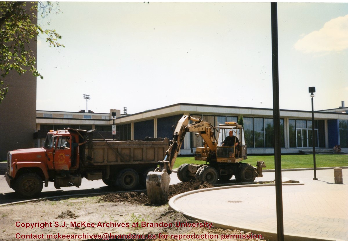
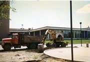
Photograph shows a backhoe and a dump truck on the north side of McMaster Hall during the landscaping of the flower bed on the southeast corner of the George T. Richardson Centre (John E. Robbins Library). The Dining Hall is in the background.
Subject Access
campus photographs
campus buildings
Images
Show Less
Part Of
Brandon University Photograph collection
Description Level
Item
GMD
graphic
Date Range
c. 1985
Part Of
Brandon University Photograph collection
Description Level
Item
Series Number
2.1
Item Number
BUPC 2.1.60
GMD
graphic
Date Range
c. 1985
Physical Description
5" x 3.5" (colour)
Scope and Content
Photograph shows the removal of one of the houses formerly located on 20th Street between Louise and Princess Avenues. The houses on those blocks were removed to create parking lots for the University. A Fed Zavislak Ltd. Well Drilling & Trucking pickup truck is visible at the curb.
Subject Access
campus photographs
Brandon streets
Images
Show Less

20 records – page 1 of 1.