Photograph of east side of 10th Street, Brandon, Manitoba, between Rosser and Princess Avenues. Visible businesses include: The Bank of Montreal, Barclay's Shoe Store, Carlton Cafe (in the former Cigar Factory), and Ted Heming Jewellers. The McKenzie Seed building is visible in the background.
Photograph shows the recently constructed Strathcona Block. H. Lamontagne & Co. Ltd., Wholesale, occupies the ground floor. Scaffolding is suspended from the north side of the building. Buildings have yet to be erected to the north and south sides of the Strathcona Block.
Notes
Back of photograph is stamped: Hughes & Co. Ltd., 1009 Princess Ave., Brandon, Man.
Photograph shows the intersection of 10th Street and Princess Avenue, Brandon, Manitoba. View is facing northwest along west side of the 100-block of 10th Street. A stationary policeman/divider is at the centre of the intersection. Visible businesses include: Doig's, Plaza Shoe Shop, and Cambridge Clothes Shop. A horse-drawn sled is parked in front of Doig's store. The Olympia Block, Cecil Hotel, and CPR Station are visible in the background.
Photograph of 10th Street facing north from Princess Avenue. Vehicles are parallel parked on both sides of the street. The Welcome Brandon sign can be seen at the Rosser Avenue intersection.
Visible businesses on the west side of 10th Street include: Doig's, Box Brothers Hardware and Allied Hardware Stores in the Alexandra Block; followed by Simpsons-Sears in the Strathcona Block. Barry Neill Men's Wear, Kresge's and the Cecil Hotel are also visible. The Johnny Smith Block is visible in the background.
Visible businesses on the east side of 10th Street include: Ollies Steaks and Chops, Elna Sewing Centre, Carlton Cafe, Chop Suey. At the base of the hill the Canadian Pacific train station is visible at the base of the hill.
Notes
Writing on the front of the postcard reads: Tenth St. Brandon, Man.
Postcard shows an aerial view of 9th Street facing south in Brandon, Manitoba. Visible businesses and landmarks include: Beaubier Hotel, YMCA/police station, the original CKX Radio station towers on 8th Street (est. 1928 - moved 1940), the old City Hall, Prince Edward Hotel, and the original Manitoba Power commission smokestack on 10th Street.
Notes
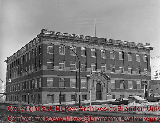
Writing on the front of the photograph reads: Brandon, Man., Jerrett Photo. This photograph shows a rare view of the 800-block between Rosser and Princess Avenues.
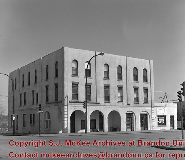
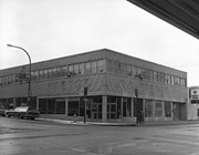
The Bank of Montreal rebuilt the former Bass Building directly across from it (southwest corner of 10th St. and Rosser Ave.), and moved into their new facilities in 1982.
Custodial History
For custodial history see the collection level description of the Lawrence Stuckey collection.
Scope and Content
Bank of Montreal
Notes
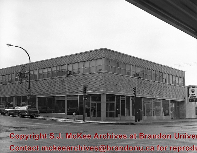
View of the southeast corner of 10th St. & Rosser Ave.
Built in 1956 on the southeast east corner of 10th St. and Rosser Avenue (former site of the Olympia Cafe)
In the summer of 1981 the S.S. Kresge store closed, and the Bass Building was purchased by the Bank of Montreal with the intention to renovate and open in 1982.
Custodial History
For custodial history see the collection level description of the Lawrence Stuckey collection.
Scope and Content
Bass Building (ex. S.S. Kresge store)
Notes
[Mr. Stuckey indicated on the envelope that there are two negatives, but only one in enclosed.]
Photograph shows Princess Avenue facing east from 10th Street. On the north side of Princess Avenue, a B/A Service Station, Princess Cafe, Lindenberg Seeds, and the Central Fire Station are visible. Old City Hall with the war memorial and the Prince Edward Hotel are visible on the south side of Princess Avenue. Traffic is travelling one-way on Princess Avenue.
Red ink stain is on the front right corner of postcard
Scope and Content
Photograph shows 10th Street facing south from Princess Avenue. Visible landmarks and businesses include: Manitoba Power Commission (MPC)'s power sub-station, First Baptist Church, Wheat City Arena, and the grand stand at the Exhibition Grounds.
The partial sign visible at the bottom of the photograph on the east side of 10th Street reads Yates and Neale, which refers to a plumbing and heating company that dissolved in 1943 to be replaced by Neale, Stothard and Chapman.
Businesses on the west side of 10th Street include: Dominion Tire & Radio Co., Bolts Barber Shop, Elviss T.E. Co. Stables.
Notes
Information concerning Yates and Neale courtesy Jack Stothard. Writing on the front of the postcard reads: Brandon, Looking S.W., Jerrett Photo. This photograph shows a rare view of the 200-block of 10th Street.
For custodial history see the collection level description of the Lawrence Stuckey collection.
Scope and Content
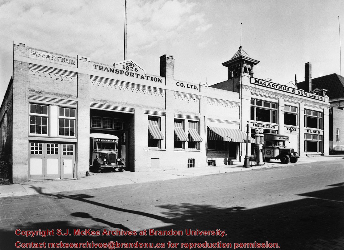
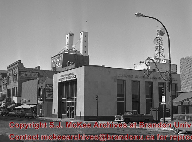
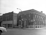
This image shows commercial buildings located on the west side of the 100 block of 10th Street.
Businesses shown include Doig's Home Furnishings
Notes
[Mr. Stuckey put three negatives and three prints in same envelope. We have separated them and numbered the negatives EA4(1) through EA4(3), and the prints EA4(1a) through EA4(3a).]
For custodial history see the collection level description of the Lawrence Stuckey collection.
Scope and Content
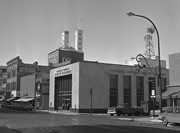
This image shows commercial buildings located on the west side of the 100 block of 10th Street.
Businesses shown include Doig's Home Furnishings
Notes
[Mr. Stuckey put three negatives and three prints in same envelope. We have separated them and numbered the negatives EA4(1) through EA4(3), and the prints EA4(1a) through EA4(3a).]


.jpg?width=1200&404=no-img.jpg&watermark=wmk)
.jpg?width=180&404=no-img.jpg)
.jpg?width=1200&404=no-img.jpg&watermark=wmk)
.jpg?width=180&404=no-img.jpg)
.jpg%3fmaxheight%3d1000%26maxwidth%3d1000%26watermark%3dwmk&description=10th+Street+Businesses+-+West+Side+of+100+Block)
.jpg%3fmaxheight%3d1000%26maxwidth%3d1000%26watermark%3dwmk&description=10th+Street+Businesses+-+West+Side+of+100+Block)