For custodial history see the collection level description of the Lawrence Stuckey collection.
Scope and Content
Aerial view of downtown Brandon, including area of new Gallery Mall.
Notes
[This eastward aerial view of downtown Brandon seems to portray an outdoor second-story parking garage proposed by the architectural firm Ward, MacDonald and Partners. The proposed overhead parking is depicted as running continuously from Sixth Street to Tenth Street along Rosser Avenue. The negative appears to have been made by photographing an existing illustration. P.E. 03/06/09]
For custodial history see the collection level description of the Lawrence Stuckey collection.
Scope and Content
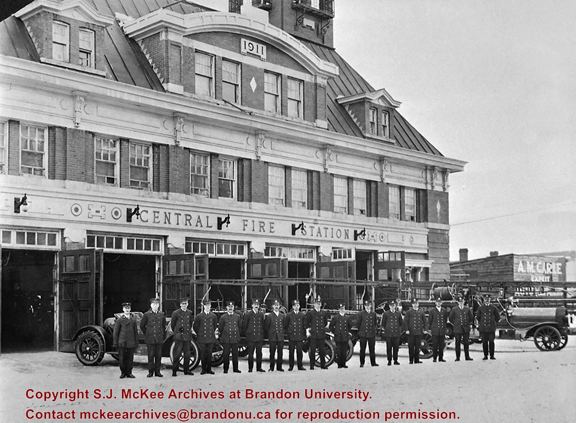
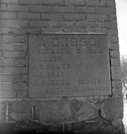
Brandon Fire Department in front of new (1911) Central Fire Station. From L to R: Chief John Melhuish; Capt. Alex Mowatt; Lieut. I. Adams; Lieut. Bain; Private Jim Ward; Frank Stock; Alf Granger; Jim Selbie; Friesen; Frank Metise, Mechanic; Art Hayes; Bill Carey; Bob Cameron; Frank Elburn; Frank Benson; Jack Sedran.
Notes
Showing four motor vehicles
Names provided by Amanda Dupuis, Brandon Fire & Emergency Services. Her copy of the photograph indicates that the photo was taken in 1922 or 1923.
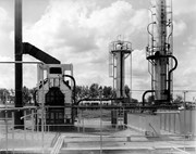
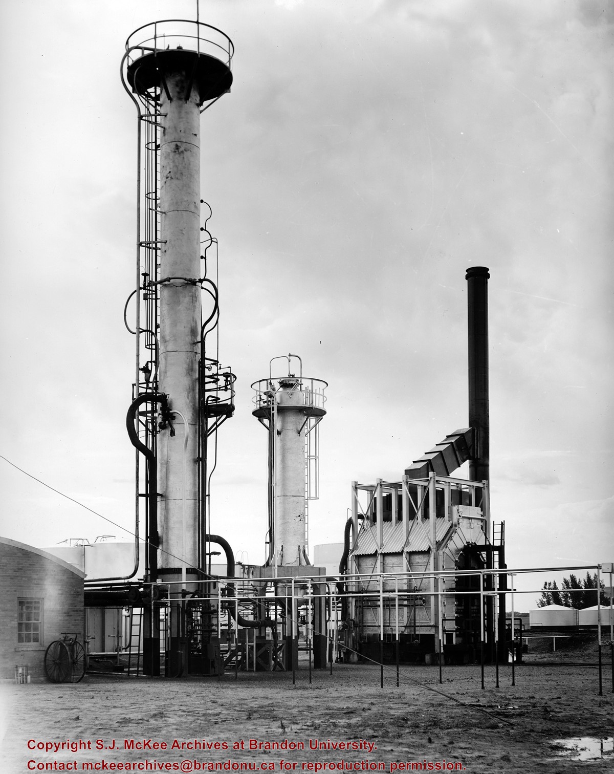
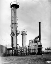
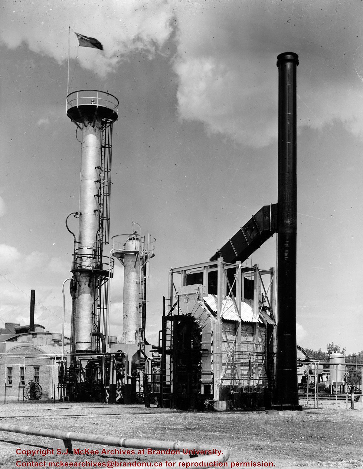
Central Refiners, which opened in 1936, was located at the southeast corner of 18th Street and Richmond Avenue. Initially owned and operated locally, the refinery was born from one of the old skimming plants that predated refining in Western Canada. That early plant skimmed the gasoline products from Turner Valley crude oil, using the collection material basically as tractor fuels to supply the farmers of the area.
The operation took a big step forward when it was allied with Anglo Canadian, a Calgary-based oil drilling exploration company, and turned into a proper refinery to refine the crude oil. That crude oil was hauled to Brandon by tank cars from the Anglo Canadian Turner Valley wells until about 1950 when the first trans-Canada popline was completed and a loop extended to the Brandon refinery.
In the early 1940s, shortly after it had been completed as a catalytic refinery, the plant went in to war production, producing the aviation gasolines used by the Commonwealth Air Trining Program in western Manitoba.
As Central REfiners and as Anglo Canadian Oils, the company was essentially a local one with businessmen and farmers of Brandon and western Manitoba owning big portions of the shares. In 1951, the British American Oil company purchased sharsin Anglo Canadian Oils and in 1964 BA became the principal owner.
Due to techonological and economic factors British American Oil Company decided to close the Brandon refinery, effective April 1, 1969.
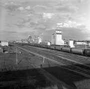
Scope and Content
Photograph of Central Refiners.
Notes
History/Bio information taken from the article "Death knell for refinery" in the September 18, 1968 edition of the Brandon Sun.
Repro Restriction
The McKee Archives is the copyright holder for the Stuckey materials.
Central Refiners, which opened in 1936, was located at the southeast corner of 18th Street and Richmond Avenue. Initially owned and operated locally, the refinery was born from one of the old skimming plants that predated refining in Western Canada. That early plant skimmed the gasoline products from Turner Valley crude oil, using the collection material basically as tractor fuels to supply the farmers of the area.
The operation took a big step forward when it was allied with Anglo Canadian, a Calgary-based oil drilling exploration company, and turned into a proper refinery to refine the crude oil. That crude oil was hauled to Brandon by tank cars from the Anglo Canadian Turner Valley wells until about 1950 when the first trans-Canada popline was completed and a loop extended to the Brandon refinery.
In the early 1940s, shortly after it had been completed as a catalytic refinery, the plant went in to war production, producing the aviation gasolines used by the Commonwealth Air Trining Program in western Manitoba.
As Central REfiners and as Anglo Canadian Oils, the company was essentially a local one with businessmen and farmers of Brandon and western Manitoba owning big portions of the shares. In 1951, the British American Oil company purchased sharsin Anglo Canadian Oils and in 1964 BA became the principal owner.
Due to techonological and economic factors British American Oil Company decided to close the Brandon refinery, effective April 1, 1969.
Scope and Content
Photograph of Central Refiners.
Notes
History/Bio information taken from the article "Death knell for refinery" in the September 18, 1968 edition of the Brandon Sun.
Repro Restriction
The McKee Archives is the copyright holder for the Stuckey materials.
These blocks of ice were used to fill the ice houses of the Wheat City Ice Co. (located north of Rosser Avenue on the west side of 15th Street, and south of Princess Avenue on the east side of 17th Street), the CPR icehouses (at the station and 3rd St. & Assiniboine Ave), and the CNR icehouse (at Forth Street and McTavish Avenue). In addition, large quantities of ice were shipped to smaller towns in railcars (usually old refrigerator cars).
Custodial History
For custodial history see the collection level description of the Lawrence Stuckey collection.
Scope and Content
Cutting ice from the Assiniboine River
Notes
This is one of five images that show the method in which ice is cut into blocks and loaded onto sleighs or trucks. Note the large draft horses still in use at this date.
[Mr. Stuckey put five negatives into the same envelope. We have separated them and numbered them H12(1) to H12(5).]
Additional information provided by the Fred McGuinness collection (20-2009).
The McKee Archives is the copyright holder for the Stuckey materials.
Storage Location
Lawrence Stuckey collection
Arrangement
[Mr. Stuckey put 8 negatives in the same envelope, numbered 1 through 10 (negatives 3 and 4 are missing). We have separated them, keeping their original numbers.]
The McKee Archives is the copyright holder for the Stuckey materials.
Storage Location
Lawrence Stuckey collection
Arrangement
[Mr. Stuckey put 8 negatives in the same envelope, numbered 1 through 10 (negatives 3 and 4 are missing). We have separated them, keeping their original numbers.]
The McKee Archives is the copyright holder for the Stuckey materials.
Storage Location
Lawrence Stuckey collection
Arrangement
[Mr. Stuckey put 8 negatives in the same envelope, numbered 1 through 10 (negatives 3 and 4 are missing). We have separated them, keeping their original numbers.]


.jpg?width=1200&404=no-img.jpg&watermark=wmk)
.jpg?width=180&404=no-img.jpg)
.jpg?width=1200&404=no-img.jpg&watermark=wmk)
.jpg?width=180&404=no-img.jpg)


.jpg?width=1200&404=no-img.jpg&watermark=wmk)
.jpg?width=180&404=no-img.jpg)
.jpg?width=1200&404=no-img.jpg&watermark=wmk)
.jpg?width=180&404=no-img.jpg)
.jpg?width=1200&404=no-img.jpg&watermark=wmk)
.jpg?width=180&404=no-img.jpg)
.jpg?width=1200&404=no-img.jpg&watermark=wmk)
.jpg?width=180&404=no-img.jpg)
.jpg?width=1200&404=no-img.jpg&watermark=wmk)
.jpg?width=180&404=no-img.jpg)

.jpg?width=1200&404=no-img.jpg&watermark=wmk)
.jpg?width=180&404=no-img.jpg)
.jpg?width=1200&404=no-img.jpg&watermark=wmk)
.jpg?width=180&404=no-img.jpg)
.jpg?width=1200&404=no-img.jpg&watermark=wmk)
.jpg?width=180&404=no-img.jpg)
.jpg%3fmaxheight%3d1000%26maxwidth%3d1000%26watermark%3dwmk&description=Aerial+View+of+Core+Area)
.jpg%3fmaxheight%3d1000%26maxwidth%3d1000%26watermark%3dwmk&description=Aerial+View+of+Core+Area)
.jpg%3fmaxheight%3d1000%26maxwidth%3d1000%26watermark%3dwmk&description=Cutting+Ice+from+the+Assiniboine+River)
.jpg%3fmaxheight%3d1000%26maxwidth%3d1000%26watermark%3dwmk&description=Cutting+Ice+from+the+Assiniboine+River)
.jpg%3fmaxheight%3d1000%26maxwidth%3d1000%26watermark%3dwmk&description=Cutting+Ice+from+the+Assiniboine+River)
.jpg%3fmaxheight%3d1000%26maxwidth%3d1000%26watermark%3dwmk&description=Cutting+Ice+from+the+Assiniboine+River)
.jpg%3fmaxheight%3d1000%26maxwidth%3d1000%26watermark%3dwmk&description=Cutting+Ice+from+the+Assiniboine+River)
.jpg%3fmaxheight%3d1000%26maxwidth%3d1000%26watermark%3dwmk&description=Brandon+from+roof+of+Christie+Building)
.jpg%3fmaxheight%3d1000%26maxwidth%3d1000%26watermark%3dwmk&description=Brandon+from+roof+of+Christie+Building)
.jpg%3fmaxheight%3d1000%26maxwidth%3d1000%26watermark%3dwmk&description=Brandon+from+roof+of+Christie+Building)