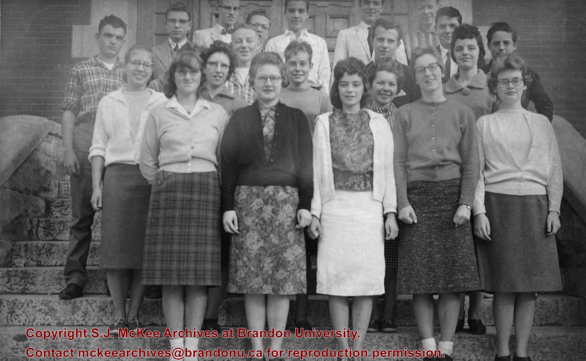
The Brandon Collegiate was built in 1907 and officially opened in 1908. Architect W.A. Elliott designed the building, which was faced with brick from Wisconsin (order 65,000 bricks). Located at 527 Louise Avenue, it ceased to be Brandon Collegiate Institute (BCI) in the summer of 1974. It was renamed New Era School on the recommendation of Marion Pye, who was a teacher at BCI in its last years. The name "New Era" was also the name of the BCI yearbook.
Custodial History
Sent to Fred McGuinness from Martin Kavanagh of Brandon.
Scope and Content
Photograph is an outdoor class picture of Brandon Collegiate Institute students standing on the front steps of the school.
Notes
History/bio information obtained from Lawrence Stuckey descriptions and the Manitoba Historical Society website. The negative for this photograph can be found in McG 1.2 File 19.
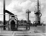
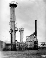
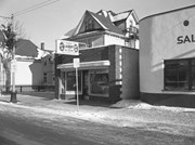
Central Refiners, which opened in 1936, was located at the southeast corner of 18th Street and Richmond Avenue. Initially owned and operated locally, the refinery was born from one of the old skimming plants that predated refining in Western Canada. That early plant skimmed the gasoline products from Turner Valley crude oil, using the collection material basically as tractor fuels to supply the farmers of the area.
The operation took a big step forward when it was allied with Anglo Canadian, a Calgary-based oil drilling exploration company, and turned into a proper refinery to refine the crude oil. That crude oil was hauled to Brandon by tank cars from the Anglo Canadian Turner Valley wells until about 1950 when the first trans-Canada popline was completed and a loop extended to the Brandon refinery.
In the early 1940s, shortly after it had been completed as a catalytic refinery, the plant went in to war production, producing the aviation gasolines used by the Commonwealth Air Trining Program in western Manitoba.
As Central REfiners and as Anglo Canadian Oils, the company was essentially a local one with businessmen and farmers of Brandon and western Manitoba owning big portions of the shares. In 1951, the British American Oil company purchased sharsin Anglo Canadian Oils and in 1964 BA became the principal owner.
Due to techonological and economic factors British American Oil Company decided to close the Brandon refinery, effective April 1, 1969.
Scope and Content
Photograph of Central Refiners.
Notes
History/Bio information taken from the article "Death knell for refinery" in the September 18, 1968 edition of the Brandon Sun.
Repro Restriction
The McKee Archives is the copyright holder for the Stuckey materials.
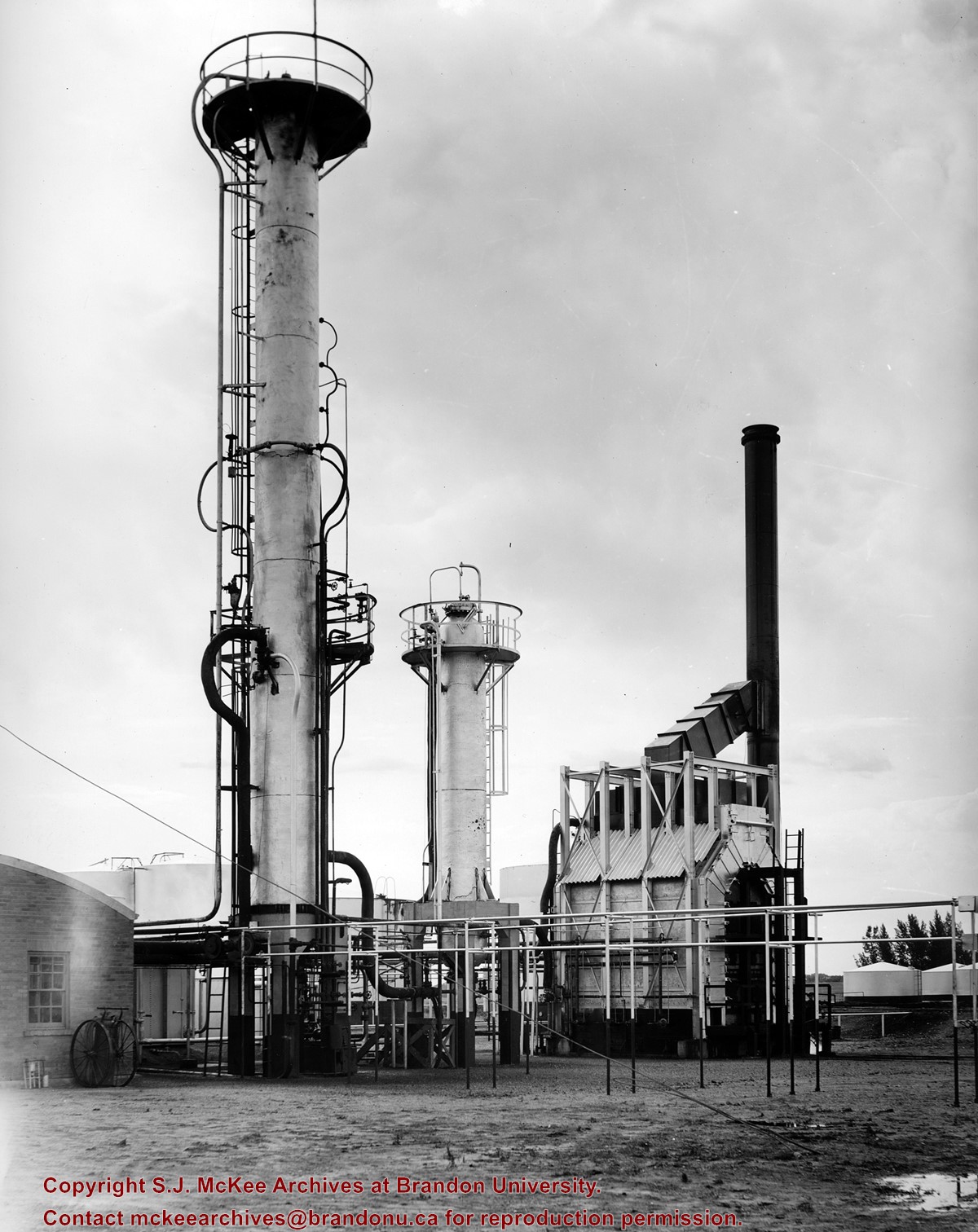
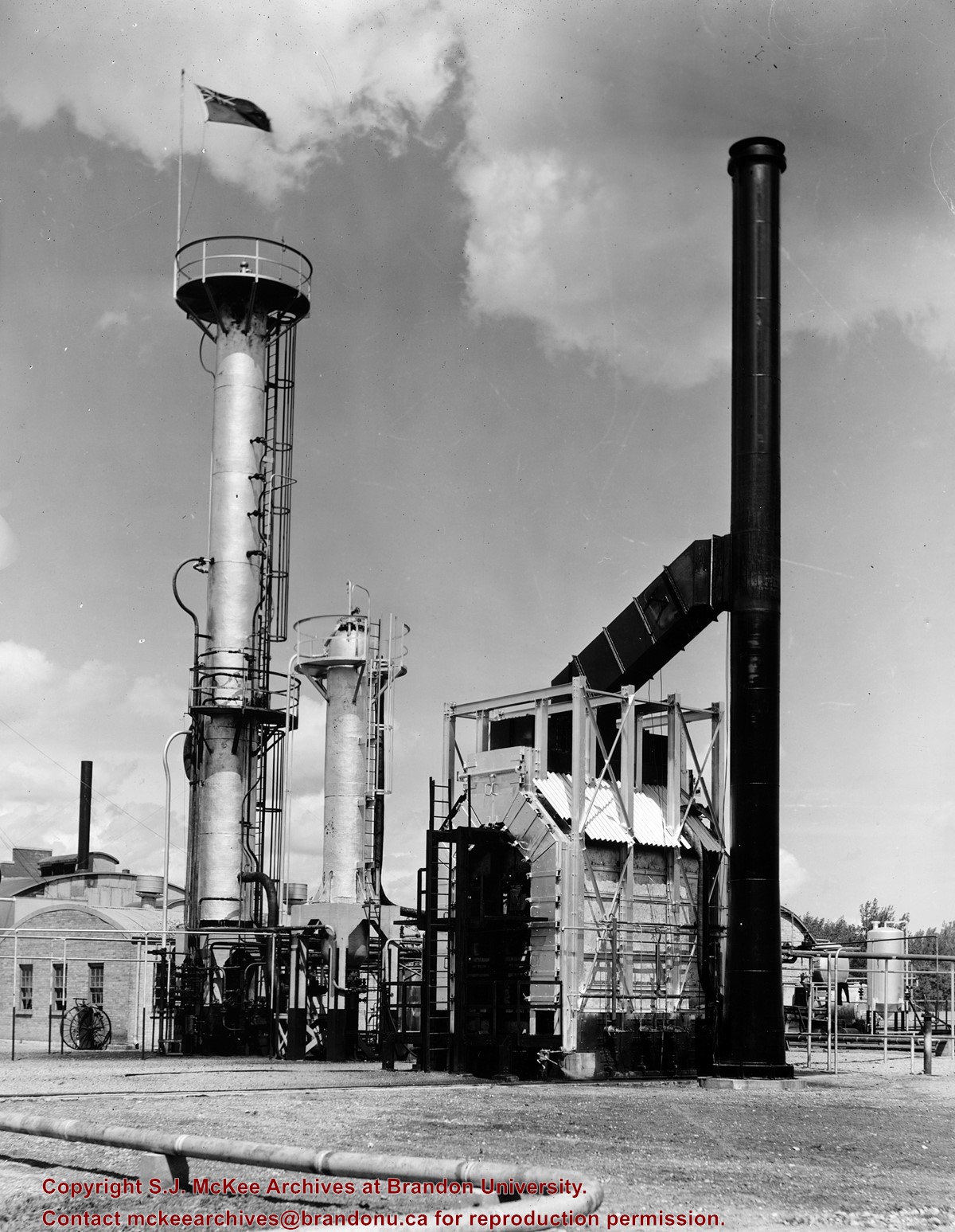
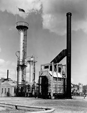
View is southwest from approximatley 16th Street between Princess and Rosser Avenues. Photograph shows the Brandon University campus, as well as surrounding residential blocks, including Flemming, J.R. Reid and Vincent Massey schools.
View is west southwest from approximatley 16th Street between Princess and Lorne Avenues. Photograph shows the Brandon University campus, as well as surrounding residential blocks between 16th and 23rd Streets, Princess and Louise Avenues..
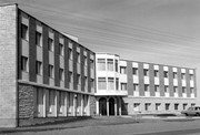
View is west from approximatley 17th Street between Lorne and Louise Avenues. Photograph shows a portion of the Brandon University campus (excluding the Education Building and anything north of it), as well as surrounding residential blocks from approximatley 17th Street to 22nd Street.
View is west northwest from approximatley 16th Street and Louise Avenue. Photograph shows the Brandon University campus, prior to the Library Extension, and a large portion of the city to the west of the campus.
View is northwest from approximatley 16th Street and Louise Avenue. Photograph shows the Brandon University campus, prior to the Library Extension, and a large portion of the city to the west of the campus.
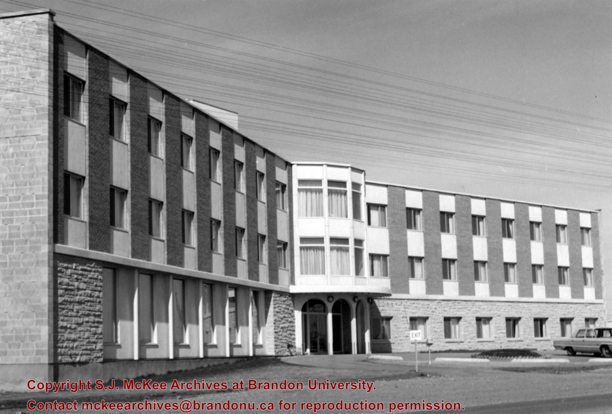
Image shows the Brandon College campus from 17th Street looking southwest. The photo was taken after the completion of the original Music Building in 1963, but construction of the Education Building. Also visible are a number of properties on the 200 block of 18th Street and the 200 block of 20th Street.
These blocks of ice were used to fill the ice houses of the Wheat City Ice Co. (located north of Rosser Avenue on the west side of 15th Street, and south of Princess Avenue on the east side of 17th Street), the CPR icehouses (at the station and 3rd St. & Assiniboine Ave), and the CNR icehouse (at Forth Street and McTavish Avenue). In addition, large quantities of ice were shipped to smaller towns in railcars (usually old refrigerator cars).
Custodial History
For custodial history see the collection level description of the Lawrence Stuckey collection.
Scope and Content
Cutting ice from the Assiniboine River
Notes
This is one of five images that show the method in which ice is cut into blocks and loaded onto sleighs or trucks. Note the large draft horses still in use at this date.
[Mr. Stuckey put five negatives into the same envelope. We have separated them and numbered them H12(1) to H12(5).]
Additional information provided by the Fred McGuinness collection (20-2009).
.jpg?width=1200&404=no-img.jpg&watermark=wmk)
.jpg?width=180&404=no-img.jpg)
.jpg?width=1200&404=no-img.jpg&watermark=wmk)
.jpg?width=180&404=no-img.jpg)


.jpg?width=1200&404=no-img.jpg&watermark=wmk)
.jpg?width=180&404=no-img.jpg)
.jpg?width=1200&404=no-img.jpg&watermark=wmk)
.jpg?width=180&404=no-img.jpg)
.jpg?width=1200&404=no-img.jpg&watermark=wmk)
.jpg?width=180&404=no-img.jpg)
.jpg?width=1200&404=no-img.jpg&watermark=wmk)
.jpg?width=180&404=no-img.jpg)
.jpg%3fmaxheight%3d1000%26maxwidth%3d1000%26watermark%3dwmk&description=Aerial+View+of+Core+Area)
.jpg%3fmaxheight%3d1000%26maxwidth%3d1000%26watermark%3dwmk&description=Aerial+View+of+Core+Area)
.jpg%3fmaxheight%3d1000%26maxwidth%3d1000%26watermark%3dwmk&description=Cutting+Ice+from+the+Assiniboine+River)
.jpg%3fmaxheight%3d1000%26maxwidth%3d1000%26watermark%3dwmk&description=Cutting+Ice+from+the+Assiniboine+River)
.jpg%3fmaxheight%3d1000%26maxwidth%3d1000%26watermark%3dwmk&description=Cutting+Ice+from+the+Assiniboine+River)
.jpg%3fmaxheight%3d1000%26maxwidth%3d1000%26watermark%3dwmk&description=Cutting+Ice+from+the+Assiniboine+River)