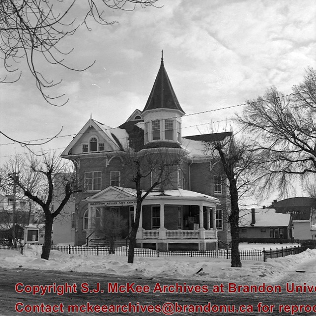
Former home of J.E. Smith, early farmer, horse breeder and businessman - died 1919. Became city property. To Allied Arts Council 1950's. Arts Centre moved to former Co-op Store, 600 block of Princess Ave. 1984.
[In 2000, the renamed Art Gallery of Southwestern Manitoba moved to the former Eaton’s building attached to The Town Centre (former Gallery Mall). P.E. 05/06/09]
Custodial History
For custodial history see the collection level description of the Lawrence Stuckey collection.
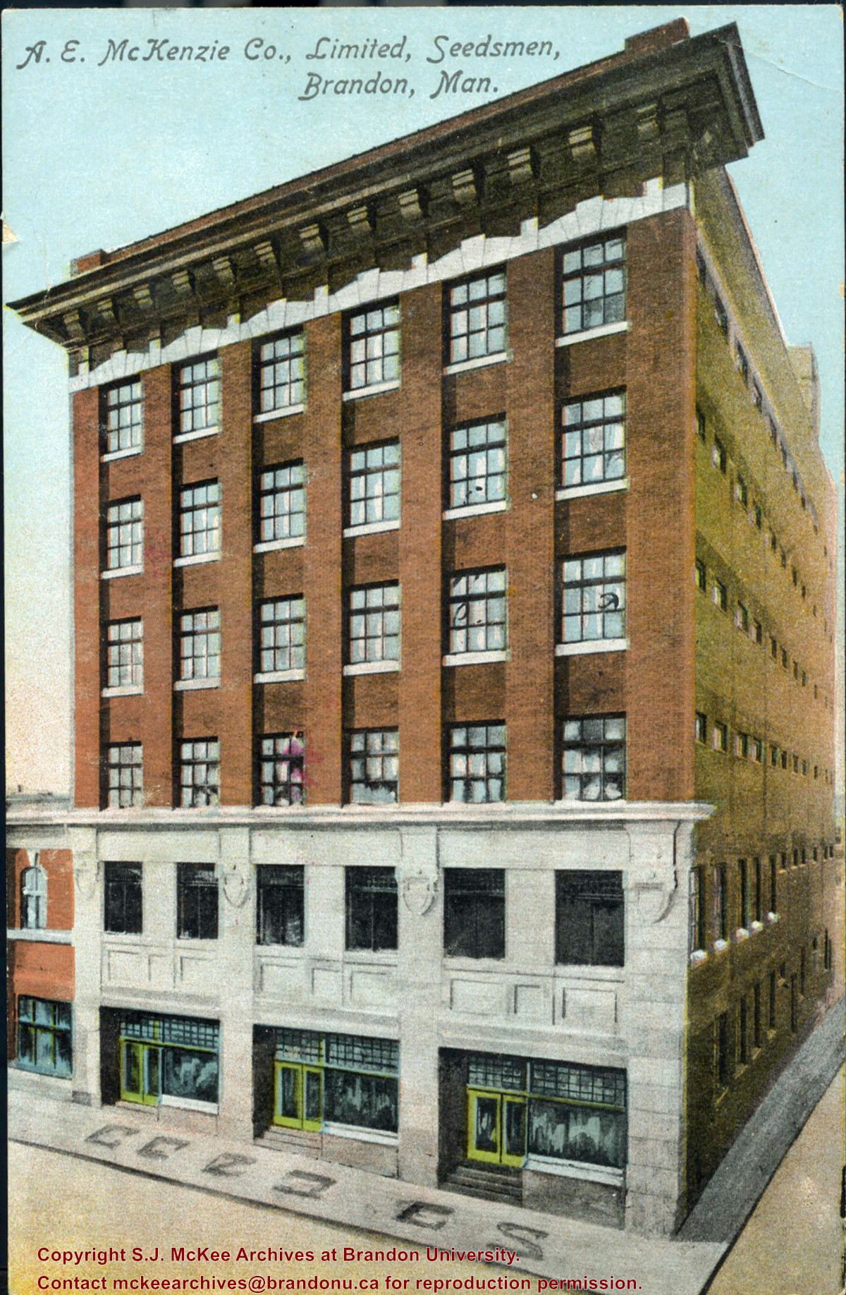
Postcard was sent to Chuck Wilson's aunt, Mrs. W.M. Wilson in Creelman, SK by the McKenzie Seed Company in 1912. Chuck Wilson found the postcard in some of his aunt's papers in 2009 and mailed it to the McKee Archives.
Scope and Content
Item consists of a colour postcard of the McKenzie Seed Company building located on the west side of the 100 block of 9th Street. The card was sent to Mrs. W.M. Wilson of Creelman, SK to acknowledge her order.
Writing on the front of the card reads: A.E. McKenzie Co., Limited, Seedsmen, Brandon, Man
The Strome & White Co. General Store (L. foreground; built 1902) became Brandon Hardware & Brandon Hardware block, later Ashdowns; The final tenant was Stylerite Hardware with two floors of residential suites. It was destroyed by fire March 27, 1983
Custodial History
For custodial history see the collection level description of the Lawrence Stuckey collection.
Scope and Content
View of Rosser Avenue, looking east from Seventh Street
The Brandon Club (L. of center) was built in 1904. This local businessmen's club met in the old firehall until this building was erected by them.
[The Brandon Club closed and its assets were sold at auction on 18 June 2005. P.E. 01/06/2009]
Custodial History
For custodial history see the collection level description of the Lawrence Stuckey collection.
Scope and Content
Overhead view of Princess Avenue, west of 10th Street
Notes
Taken from roof of Prince Edward Hotel. Shows: Rat Portage Lumber Co., St. Matthew's Hall, Brandon Club, In distance Brandon College, International Harvester, Pumping Station. End of brick pavement at 14th Street is notable.
For custodial history see the collection level description of the Lawrence Stuckey collection.
Scope and Content
West side of Sixth Street, north of Rosser Avenue; looking north
Notes
Businesses displayed (S to N) include: Winter & O'Neill - general store; James A. Smart - hardware; Grand Central Hotel - built 1882, razed 1890; American House - hotel; Brandon House (far end) - hotel
The Queen's hotel was located on the corner of Rosser Avenue and Tenth Street (Steen & Boyce, 1882. Brandon, Manitoba, Canada and Her Industries. Steen & Boyce Publishers Printers & Binders, 81.). Therefore this photo appears to display Rosser Avenue looking east. P.E. 11/06/09
Custodial History
For custodial history see the collection level description of the Lawrence Stuckey collection.
Scope and Content
Queen's Hotel, Robinson Bros. & Co. Drygoods, etc.
Notes
Street scene with new construction. Collection: Fred McGuinness
Bylaws to keep cattle off streets were being debated by city council about this time.
Custodial History
For custodial history see the collection level description of the Lawrence Stuckey collection.
Scope and Content
J. Birtles Meat Market "Family Butcher", 608 Rosser Avenue
Notes
Mr. Birtles on right, including Mr. Hammell, Hiram Chesley, and Lew Wicket; Photo includes Red Cross Drug Store with proprietor Mr. McCullagh in front; From Brandon Sun files.
[The land on which city hall stood in this photo is now known as Princess Park. P.E. 01/06/09]
Custodial History
For custodial history see the collection level description of the Lawrence Stuckey collection.
Scope and Content
Princess Avenue, showing City Hall & CKX radio tower
Notes
[View is from 9th Street looking east. P.E.]
"Radio towers of CKX on city hall grounds were 150 feet tall; Studio and transmitter were on the east side of city hall." - Fred McGuinness collection (20-2009).
For custodial history see the collection level description of the Lawrence Stuckey collection.
Scope and Content
View of the southeast corner of Tenth Street and Princess Avenue, showing the Prince Edward Hotel (left) and an Imperial Oil Building (right).
Notes
The second floor of the Imperial Oil building became the Imperial Dance Garden in 1934. The small wooden post in a concrete foundation in the centre of the intersection was called a "Silent Policeman". You were supposed to keep it on your left while making a left turn. They took quite a beating.
[Information in "Notes" provided by the Fred McGuinness collection (20-2009).]
The McKee Archives is the copyright holder for the Stuckey materials.
Storage Location
Lawrence Stuckey collection
Arrangement
[Mr. Stuckey put a negative in the envelope and taped the print to the outside. We have separated them and numbered the negative D13(1) and the print D13(1a).]
The McKee Archives is the copyright holder for the Stuckey materials.
Storage Location
Lawrence Stuckey collection
Arrangement
[Mr. Stuckey put a negative in the envelope and taped the print to the outside. We have separated them and numbered the negative D13(1) and the print D13(1a).]


.jpg?width=1200&404=no-img.jpg&watermark=wmk)
.jpg?width=180&404=no-img.jpg)
.jpg?width=1200&404=no-img.jpg&watermark=wmk)
.jpg?width=180&404=no-img.jpg)


.jpg%3fmaxheight%3d1000%26maxwidth%3d1000%26watermark%3dwmk&description=Western+Manitoba+Centennial+Auditorium)
.jpg%3fmaxheight%3d1000%26maxwidth%3d1000%26watermark%3dwmk&description=Western+Manitoba+Centennial+Auditorium)