Skip header and navigation

Revise Search

20 records – page 12 of 1.

Brandon from river bend north

http://archives.brandonu.ca/en/permalink/descriptions11499
Part Of
CKX fonds
Description Level
Item
GMD
graphic
Date Range
after 1954
Accession Number
11-2010
Part Of
CKX fonds
Creator
CKX
Description Level
Item
Item Number
11-2010.B75
Accession Number
11-2010
GMD
graphic
Date Range
after 1954
Physical Description
1.5" x 1" (b/w)
Material Details
Negative
Custodial History
See fonds level of the CKX records for custodial history.
Scope and Content
Image of Brandon viewed from a bend in the Assiniboine River north of the city.
Name Access
CKX Television
Brandon, Manitoba
Subject Access
landscapes
Landscape Photography
Storage Location
CKX fonds - 2010 accessions
Images
Show Less
Part Of
CKX fonds
Description Level
Item
GMD
graphic
Date Range
after 1954
Accession Number
11-2010
Part Of
CKX fonds
Creator
CKX
Description Level
Item
Item Number
11-2010.A3a
Accession Number
11-2010
GMD
graphic
Date Range
after 1954
Physical Description
5" x 4" (b/w)
Material Details
Negative
Custodial History
See fonds level of the CKX records for custodial history.
Scope and Content
Portrait of R.C. Aitkins.
Name Access
R.C. Aitkins
CKX
Subject Access
television broadcasting
photography
Storage Location
CKX fonds - 2010 accessions
Images
Show Less
Part Of
CKX fonds
Description Level
Item
GMD
graphic
Date Range
after 1954
Accession Number
11-2010
Part Of
CKX fonds
Creator
CKX
Description Level
Item
Item Number
11-2010.A3b
Accession Number
11-2010
GMD
graphic
Date Range
after 1954
Physical Description
5" x 4" (b/w)
Material Details
Negative
Custodial History
See fonds level of the CKX records for custodial history.
Scope and Content
Portrait of R.C. Aitkins.
Name Access
R.C. Aitkins
CKX
Subject Access
television broadcasting
photography
Storage Location
CKX fonds - 2010 accessions
Images
Show Less

Lorne Avenue at 18th Street intersection

http://archives.brandonu.ca/en/permalink/descriptions13817
Part Of
Fred McGuinness collection
Description Level
Item
GMD
graphic
Date Range
1922
Accession Number
20-2009
Part Of
Fred McGuinness collection
Description Level
Item
Series Number
McG 9
Item Number
20-2009.127
Accession Number
20-2009
GMD
graphic
Date Range
1922
Physical Description
5" x 7" (b/w)
Material Details
reproduction
Physical Condition
Developing artifacts present
Custodial History
Donated to Fred McGuinness by G. Baldock in 1971
Scope and Content
Photograph shows Lorne Avenue facing east.
Notes
Writing on the back of the photograph reads: Lorne Avenue at 18th St., 1922
Name Access
Lorne Avenue
Subject Access
residential streets
street scenes
Storage Location
RG 5 photograph storage drawer 2 (hanging photos)
Arrangement
From 2009 loose photos
Images
Show Less

Christine McGuinness

http://archives.brandonu.ca/en/permalink/descriptions14061
Part Of
Fred McGuinness collection
Description Level
Item
GMD
graphic
Date Range
[1940s]
Accession Number
1-2015
Part Of
Fred McGuinness collection
Description Level
Item
Series Number
McG 9
Item Number
1-2015.131
Accession Number
1-2015
GMD
graphic
Date Range
[1940s]
Physical Description
3" x 2" (b/w)
Scope and Content
Photograph shows a young woman, possibly Christine McGuinness (nee Thompson), standing in a yard.
Name Access
Christine McGuinness
Subject Access
street scenes
residential streets
Storage Location
RG 5 photograph storage drawer 2 (hanging photos)
Arrangement
BR #3 Family pictures
Images
Show Less
Part Of
CKX fonds
Description Level
Item
GMD
graphic
Date Range
after 1954
Accession Number
11-2010
Part Of
CKX fonds
Creator
CKX
Description Level
Item
Series Number
H
Item Number
11-2010.H8a
Accession Number
11-2010
GMD
graphic
Date Range
after 1954
Physical Description
5" x 4" (b/w)
Material Details
Negative
Custodial History
See fonds level of the CKX records for custodial history.
Scope and Content
Image of the southside of the 1000 and 1100 block of Rosser Avenue looking east in winter. Visible in the foregraound are O.L. Harwood Ltd., and the Key Kafe. Buildings in the 1000 block include: the Imperial Bank of Canada, the original Post Office and Federal Building and the original Merchants Bank. A number of pedestrians are also visible, as are Christmas decorations on the streetlights and telephone poles.
Name Access
CKX
O.L. Harwood Ltd.
Key Kafe
Rosser Avenue
11th Street
Subject Access
street scenes
downtown
winter
building exteriors
real estate brokers
insurance agents
cafes
restaurants
banks
Storage Location
CKX fonds - 2010 accessions
Images
Show Less

Aerial view: Brandon College looking west

http://archives.brandonu.ca/en/permalink/descriptions595
Part Of
Aerial views and campus photographs
Description Level
Item
GMD
graphic
Date Range
c. spring 1963
Part Of
Aerial views and campus photographs
Description Level
Item
Series Number
2.1
Item Number
2.1.3
GMD
graphic
Date Range
c. spring 1963
Physical Description
10" x 8" (b/w)
Scope and Content
View is west to McDiarmid Drive from approximately 16th Street between Princess and Louise Avenues. Photograph shows: Brandon College, Fleming School, Coronation Park, and West End Community Centre.
Images
Show Less

Aerial view: Brandon College Steam Plant

http://archives.brandonu.ca/en/permalink/descriptions596
Part Of
Aerial views and campus photographs
Description Level
Item
GMD
graphic
Date Range
c. spring 1963
Part Of
Aerial views and campus photographs
Description Level
Item
Series Number
2.1
Item Number
2.1.4
GMD
graphic
Date Range
c. spring 1963
Physical Description
10" x 8" (b/w)
Scope and Content
View is northwest from the corner of 18th Street and Louise Avenue. Photograph shows the Brandon College campus, the Steam Plant and Kinsmen Stadium. Flora Cowan Hall is under construction.
Images
Show Less

Aerial view: Brandon College and downtown east

http://archives.brandonu.ca/en/permalink/descriptions597
Part Of
Aerial views and campus photographs
Description Level
Item
GMD
graphic
Date Range
c. spring 1963
Part Of
Aerial views and campus photographs
Description Level
Item
Series Number
2.1
Item Number
2.1.5
GMD
graphic
Date Range
c. spring 1963
Physical Description
10" x 8" (b/w)
Scope and Content
View is east southeast from approximately 22nd Street between Princess and Louise Avenues. Photograph shows: Brandon College, Stanley Park, Park School, Prince Edward Hotel, First Baptist Church, First Presbyterian Church, Wheat City Arena, First Church United, St. Paul's, Central United Church.
Images
Show Less

Aerial view: Brandon College looking northwest

http://archives.brandonu.ca/en/permalink/descriptions599
Part Of
Aerial views and campus photographs
Description Level
Item
GMD
graphic
Date Range
late 1960s
Part Of
Aerial views and campus photographs
Description Level
Item
Series Number
2.1
Item Number
2.1.7
GMD
graphic
Date Range
late 1960s
Physical Description
5" x 4" (b/w)
Scope and Content
Brandon College. Looking north west over the valley after 1963 Music Building opening, but before trees were moved to the quadrangle.
Images
Show Less

Aerial view: Brandon College tree planting

http://archives.brandonu.ca/en/permalink/descriptions604
Part Of
Aerial views and campus photographs
Description Level
Item
GMD
graphic
Date Range
c. 1964
Part Of
Aerial views and campus photographs
Description Level
Item
Series Number
2.1
Item Number
2.1.11
GMD
graphic
Date Range
c. 1964
Physical Description
5" x 4" (b/w)
Scope and Content
View is east northeast from approximately 22nd Street between Lorne and Louise Avenues. Photograph shows: Brandon College (before planting of trees in quadrangle and before the Education Building), McKenzie Seeds, Prince Edward Hotel, Central United (St. Paul's) Church, St. Augustine's Church.
Images
Show Less

Aerial view: Brandon College looking east

http://archives.brandonu.ca/en/permalink/descriptions617
Part Of
Aerial views and campus photographs
Description Level
Item
GMD
graphic
Date Range
c. 1963
Part Of
Aerial views and campus photographs
Description Level
Item
Series Number
2.1
Item Number
2.1.25
GMD
graphic
Date Range
c. 1963
Physical Description
5" x 4" (b/w)
Scope and Content
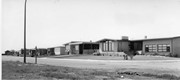
View is east from approximatley 22nd Street between Lorne and Louise Avenues. Photograph shows: Darrach Hall, Flora Cowan Hall and the Citizens' Science Building, as well as a number of homes in the area.
Images
Show Less

Brandon Municipal Railway Construction

http://archives.brandonu.ca/en/permalink/descriptions9768
Part Of
RG 11 Lawrence Stuckey fonds
Description Level
Item
GMD
graphic
Date Range
1912
Accession Number
1-2002
Part Of
RG 11 Lawrence Stuckey fonds
Description Level
Item
Series Number
3.1
Item Number
1-2002.3.1K6
Accession Number
1-2002
GMD
graphic
Date Range
1912
Physical Description
3 1/2" x 5"
Material Details
Negative
Custodial History
For custodial history see the collection level description of the Lawrence Stuckey collection.
Scope and Content
Brandon Municipal Railway construction
Notes
Looking south at the intersection of 10th Street and Rosser Avenue.
From Brandon Sun
Name Access
Brandon Municipal Railway
Subject Access
public transit
streetcars
Brandon Street Railway
Brandon Early Construction Scenes
Repro Restriction
The McKee Archives is the copyright holder for the Stuckey materials.
Storage Location
Lawrence Stuckey collection
Images
Show Less

Brandon Municipal Railway Construction

http://archives.brandonu.ca/en/permalink/descriptions9769
Part Of
RG 11 Lawrence Stuckey fonds
Description Level
Item
GMD
graphic
Date Range
1912
Accession Number
1-2002
Part Of
RG 11 Lawrence Stuckey fonds
Description Level
Item
Series Number
3.1
Item Number
1-2002.3.1K7
Accession Number
1-2002
GMD
graphic
Date Range
1912
Physical Description
3 1/2" x 5"
Material Details
Negative
Custodial History
For custodial history see the collection level description of the Lawrence Stuckey collection.
Scope and Content
Brandon Municipal Railway construction
Notes
Looking east from the intersection of 10th Street and Rosser Avenue.
From Brandon Sun
Name Access
Brandon Municipal Railway
Subject Access
public transit
streetcars
Brandon Street Railway
Brandon Early Construction Scenes
Repro Restriction
The McKee Archives is the copyright holder for the Stuckey materials.
Storage Location
Lawrence Stuckey collection
Images
Show Less

Sewer Line Construction

http://archives.brandonu.ca/en/permalink/descriptions9770
Part Of
RG 11 Lawrence Stuckey fonds
Description Level
Item
GMD
graphic
Date Range
1912
Accession Number
1-2002
Part Of
RG 11 Lawrence Stuckey fonds
Description Level
Item
Series Number
3.1
Item Number
1-2002.3.1K8
Accession Number
1-2002
GMD
graphic
Date Range
1912
Physical Description
3 1/2" x 5"
Material Details
Negative
History / Biographical
Excavated earth was loaded into a hopper, which itself was on a rail running a half block back. It was then dumped back to fill the trench where pipe installation had already been completed - Art Baker (of Art's Confectionery, NE 15th St. & Princess Ave.). This information was provided in response to a request in the Brandon Sun (Fred McGuinness) for further information.
Custodial History
For custodial history see the collection level description of the Lawrence Stuckey collection.
Scope and Content
Brandon sewer line construction
Notes
View of Pacific Avenue, looking east from 5th Street
Courtesy of Mrs. E. Harden.
Name Access
Sewer Line Construction
Subject Access
public transit
streetcars
Brandon Street Railway
Brandon Early Construction Scenes
Repro Restriction
The McKee Archives is the copyright holder for the Stuckey materials.
Storage Location
Lawrence Stuckey collection
Images
Show Less

Dominion Day on Rosser Avenue

http://archives.brandonu.ca/en/permalink/descriptions13697
Part Of
Fred McGuinness collection
Description Level
Item
GMD
graphic
Date Range
1906
Accession Number
20-2009
Part Of
Fred McGuinness collection
Description Level
Item
Series Number
McG 9
Item Number
20-2009.7
Accession Number
20-2009
GMD
graphic
Date Range
1906
Physical Description
6" x 4" (b/w)
Material Details
on matting
Physical Condition
Photographs have been glued to a backing board that has warped over time
Scope and Content
Photograph shows street view of north side of Rosser Avenue, primarily the 700 block. Horse and buggies are travelling on the avenue and pedestrians fill the sidewalks. Union Jacks and English flags are mounted from the windows on the Fleming and Beaubier blocks. Flag banners are drapped across Rosser Avenue. Businesses visible in the Fleming Block include: Lowes Brothers Clothing and Spring Park Nurseries. Businesses visible in the Beaubier Block include the Empire Hotel. Businesses east of the Empire Hotel are grocer A.M. Percival and the Brandon Hardware Company. An advertisement for the Northern Bank is affixed to a telephone pole on the southside of the street.
Notes
Writing on the front of the photograph matting reads: July 1 1906, 314. One photograph (20-2009.8) is glued below and another, 20-2009.6, is glued on the reverse side. Page appears to be from a photo album.
Name Access
Fleming Block
Lowes Brothers Clothing
Spring Park Nurseries Limited
Empire Hotel
D.W. Beaubier Block
A.M. Percival
Brandon Hardware Company
Rosser Avenue
Subject Access
Street scene
Transportation
downtown
grocers
storefronts
Dominion Day
horses
Storage Location
RG 5 photograph storage drawer 2 (hanging photos)
Images
Show Less

Sewer pipe installation along 700 block of Rosser Avenue

http://archives.brandonu.ca/en/permalink/descriptions13736
Part Of
Fred McGuinness collection
Description Level
Item
GMD
graphic
Date Range
ca. 1906
Accession Number
20-2009
Part Of
Fred McGuinness collection
Description Level
Item
Series Number
McG 9
Item Number
20-2009.46
Accession Number
20-2009
GMD
graphic
Date Range
ca. 1906
Physical Description
6.5" x 4.25" (b/w)
Material Details
on matting
Physical Condition
Photographs have been glued to a backing board that has warped over time
Scope and Content
Photograph shows street view of north side of Rosser Avenue, primarily the 700 block, along which sewer pipe is being laid. Visible buildings and businesses include: The Fleming Block with Lowes Brothers Clothing and Manitoba Farmers Hedge and Wire Fence Company, the Beaubier Block and its Empire Hotel, A.M. Percival (a grocer), the Brandon Hardware Company (600 block), and the Arlington Hotel (500 block) are visible along the north side of the avenue. The Bank of Hamilton Building is on the southeast corner of 8th Street and Rosser Avenue.
Notes
Writing on the front of the photograph matting reads: 290. Page appears to be from a photo album.
Name Access
Fleming Block
Empire Hotel
D.W. Beaubier Block
A.M. Percival
Brandon Hardware Company
Arlington Hotel
Lowes Brothers Clothing
Subject Access
Street scene
downtown
grocers
storefronts
building exteriors
sewage
construction
Storage Location
RG 5 photograph storage drawer 2 (hanging photos)
Images
Show Less

Residential, Brandon, looking east postcard

http://archives.brandonu.ca/en/permalink/descriptions13872
Part Of
Fred McGuinness collection
Description Level
Item
GMD
graphic
Date Range
1910s
Accession Number
20-2009
Part Of
Fred McGuinness collection
Creator
Published by Christie's Bookstore, Brandon, Man.
Description Level
Item
Series Number
McG 9
Item Number
20-2009.182
Accession Number
20-2009
GMD
graphic
Date Range
1910s
Physical Description
3.5" x 5.5" (colour)
Material Details
postcard
Scope and Content
Photograph shows residential area of Lorne Avenue from 14th Street facing east.
Notes
Part of "Christie's Brandon Series of Six Colored Picture Postcards of Brandon, Manitoba, The Crown Series, Published by Christie's Bookstore, Brandon, Man." [note: missing sixth postcard]. Writing on the front of the photograph reads: Residential, Brandon, Man. Looking East.
Name Access
Lorne Avenue
Subject Access
street scenes
residences
residential streets
Storage Location
RG 5 photograph storage drawer 2 (hanging photos)
Arrangement
From 20-2009 File 9
Images
Show Less

Residential Brandon, looking west postcard

http://archives.brandonu.ca/en/permalink/descriptions13875
Part Of
Fred McGuinness collection
Description Level
Item
GMD
graphic
Date Range
1910s
Accession Number
20-2009
Part Of
Fred McGuinness collection
Creator
Published by Christie's Bookstore, Brandon, Man.
Description Level
Item
Series Number
McG 9
Item Number
20-2009.185
Accession Number
20-2009
GMD
graphic
Date Range
1910s
Physical Description
3.5" x 5.5" (colour)
Material Details
postcard
Scope and Content
Photograph shows a street view of Lorne Avenue and 4th Street facing west. Brandon College can be seen at the end of Lorne Avenue.
Notes
Part of "Christie's Brandon Series of Six Colored Picture Postcards of Brandon, Manitoba, The Crown Series, Published by Christie's Bookstore, Brandon, Man." [note: missing sixth postcard]. Writing on the front of the photograph reads: Residential Brandon, Man. Looking West. Photograph likely taken from St. Augustine's Church.
Name Access
Lorne Avenue
Subject Access
residences
street scenes
residential streets
Storage Location
RG 5 photograph storage drawer 2 (hanging photos)
Arrangement
From 20-2009 File 9
Images
Show Less

McGuinness Medicine Hat residence

http://archives.brandonu.ca/en/permalink/descriptions14110
Part Of
Fred McGuinness collection
Description Level
Item
GMD
graphic
Date Range
[1960-1965]
Accession Number
1-2015
Part Of
Fred McGuinness collection
Description Level
Item
Series Number
McG 9
Item Number
1-2015.179
Accession Number
1-2015
GMD
graphic
Date Range
[1960-1965]
Physical Description
7.75" x 3.5" (b/w)
Scope and Content
Photograph shows the construction of the McGuinness home in a new housing development in Medicine Hat, 492 6th Street Northeast.
Name Access
Fred McGuinness
Frederick George McGuinness
Subject Access
residences
street scenes
residential streets
Storage Location
RG 5 photograph storage drawer 2 (hanging photos)
Arrangement
BR #3 Family photos
Images
Show Less

20 records – page 12 of 1.