Photographs have been glued to a backing board that has warped over time
Scope and Content
Photograph shows street view of north side of Rosser Avenue, primarily the 700 block, along which sewer pipe is being laid. Visible buildings and businesses include: The Fleming Block with Lowes Brothers Clothing and Manitoba Farmers Hedge and Wire Fence Company, the Beaubier Block and its Empire Hotel, A.M. Percival (a grocer), the Brandon Hardware Company (600 block), and the Arlington Hotel (500 block) are visible along the north side of the avenue. The Bank of Hamilton Building is on the southeast corner of 8th Street and Rosser Avenue.
Notes
Writing on the front of the photograph matting reads: 290. Page appears to be from a photo album.
Photograph is scratched and has been glued to a backing board that has warped over time
Scope and Content
Photograph shows street view of the northeast intersection of the 000 block of 8th Street and Rosser Avenue. Horse and buggies are parked along the east side of 8th Street. Businesses on the east side of 8th Street from Pacific to Rosser Avenues are clearly visible and include: a Lunch Room (likely Aagaard's Lunch Counter), the Hotel Imperial Annex, Liverpool House (a boarding house), R.S. Thompson and Company Real Estate Office (Land Office), a barber shop (likely J. Coulter's), Frank Gowen photography studio, and Fleming's Drug Store. A possible street fair is in progress on Rosser Avenue. One man is standing on a soap box and is surrounded by a crowd in the middle of 8th Street. Another man can be seen standing behind a booth on the northwest street corner. Building construction appears to be happening on the west corner of 8th Street and Rosser Avenue.
Notes
Writing on the front of the photograph matting reads: 297. One photograph (20-2009.80) is glued below the photograph. Another photograph is glued on the reverse side. Page appears to be from a photo album.
Photograph shows Princess Avenue facing east from 10th Street. On the north side of Princess Avenue, a B/A Service Station, Princess Cafe, Lindenberg Seeds, and the Central Fire Station are visible. Old City Hall with the war memorial and the Prince Edward Hotel are visible on the south side of Princess Avenue. Traffic is travelling one-way on Princess Avenue.
Photograph shows the Red Indian (Gasoline) Station on the north side Princess Avenue between 9th and 10th Streets, Brandon. Attached to the west side of the gas station is another shop which contains Hutchings' Drug Store. The Alexandra Block on 10th Street is visible in the background.
Photograph is scratched and has been glued to a backing board that has warped over time
Scope and Content
Photograph shows street view of intersection of the 000 block of 8th Street and Rosser Avenue. Horse and buggies are travelling on both roads. Businesses on the east side of 8th Street from Pacific to Rosser Avenues are clearly visible and include: a Lunch Room (likely Aagaard's Lunch Counter), the Hotel Imperial Annex, Liverpool House (a boarding house), R.S. Thompson and Company Real Estate Office (Land Office), a barber shop (likely J. Coulter's), Frank Gowen photography studio, and Fleming's Drug Store. A possible street fair is in progress on Rosser Avenue. One man is surrounded by a crowd adjacent to the Fleming Block, another man stands on a soap box in the middle of the intersection, while a third man is standing behind a booth. Building construction appears to be happening on the west corner of 7th Street and Rosser Avenue.
Notes
Writing on the front of the photograph matting reads: 296. One photograph (20-2009.12) is glued above and two others are glued on the reverse side. Page appears to be from a photo album.
Photograph shows the west side of the 200-block on 10th Street. Visible businesses include: Chamber of Commerce Tourist Information, Dominion Tire & Radio Co., Bonnie's Bonnet Shop, Steve's Grill, Wally's Taxi, and Western Motors Ltd. The painted advertisement for Doig, Rankin and Robertson is visible on the Alexandra Block. Christmas ornaments are displayed from light standards and include Santa Claus and a Christmas elf.
Photograph shows the west side of the 200-block on 10th Street. Visible businesses include: Chamber of Commerce Tourist Information, Dominion Tire & Radio Co., Steve's Grill, Wally's Taxi, and the garage entrances to Western Motors Ltd. A Santa Claus Christmas ornament is displayed from a light standard.
The McKee Archives is the copyright holder for the Stuckey materials.
Storage Location
Lawrence Stuckey collection
Arrangement
[Mr. Stuckey put two negatives in one envelope and taped the prints to the outside of the envelope. We have separated them and numbered the negatives CA16(1) and CA16(2) and the prints CA16(1a) and CA16(2a).]
This negative provides an excellent view of Rosser Avenue (looking east from 10th Street) in the early 20th century, and shows one of the first runs for Brandon's streetcar system.
This image was used as the cover image for Lee Clark's Brandon's Politics & Politicians.
Custodial History
For custodial history see the collection level description of the Lawrence Stuckey collection.
Photograph shows a street view of 10th Street facing north. There are many automobiles parked along the street and several pedestrians in summer dress are on the sidewalks and street. Visible business signs include: Hentzman & Co. Pianos (possibly belonging to J.J.H. McLean Co. Ltd.), the Strand Theatre, T & D Clothes, Campbell & Campbell, the CPR Station, and Bowling Alley and Billiards.
Notes
Part of "Souvenir of Brandon, Manitoba, Canada [viewbook], Printed by Photogelatine Engraving Co. Limited, Ottawa." Dates obtained from the Burchill's Music Store Henderson's Brandon City Directory listings (1927-1929). Writing on the front of the photograph reads: 10th St., looking north (C.P.R. Station at end of Street) Brandon, Man.
Photograph shows the CPR Train Station on Pacific Avenue and 10th Street.
Notes
Part of "Souvenir of Brandon, Manitoba, Canada [viewbook], Printed by Photogelatine Engraving Co. Limited, Ottawa." Dates obtained from the Burchill's Music Store Henderson's Brandon City Directory listings (1927-1929). Writing on the front of the photograph reads: CPR Station, Brandon, Man.


.jpg?width=1200&404=no-img.jpg&watermark=wmk)
.jpg?width=180&404=no-img.jpg)
.jpg?width=1200&404=no-img.jpg&watermark=wmk)
.jpg?width=180&404=no-img.jpg)
.jpg?width=1200&404=no-img.jpg&watermark=wmk)
.jpg?width=180&404=no-img.jpg)
.jpg?width=1200&404=no-img.jpg&watermark=wmk)
.jpg?width=180&404=no-img.jpg)
.jpg?width=1200&404=no-img.jpg&watermark=wmk)
.jpg?width=180&404=no-img.jpg)
.jpg?width=1200&404=no-img.jpg&watermark=wmk)
.jpg?width=180&404=no-img.jpg)
.jpg?width=1200&404=no-img.jpg&watermark=wmk)
.jpg?width=180&404=no-img.jpg)
.jpg?width=1200&404=no-img.jpg&watermark=wmk)
.jpg?width=180&404=no-img.jpg)


+north+side+Princess+Avenue+between+9th+Street+and+10th+Street%2c+Brandon%2c+Manitoba)
.jpg%3fmaxheight%3d1000%26maxwidth%3d1000%26watermark%3dwmk&description=200+block+of+Tenth+Street)
.jpg%3fmaxheight%3d1000%26maxwidth%3d1000%26watermark%3dwmk&description=200+block+of+Tenth+Street)
.jpg%3fmaxheight%3d1000%26maxwidth%3d1000%26watermark%3dwmk&description=100+block+of+Tenth+Street)
.jpg%3fmaxheight%3d1000%26maxwidth%3d1000%26watermark%3dwmk&description=Northeast+view+from+100+block+of+Tenth+Street)
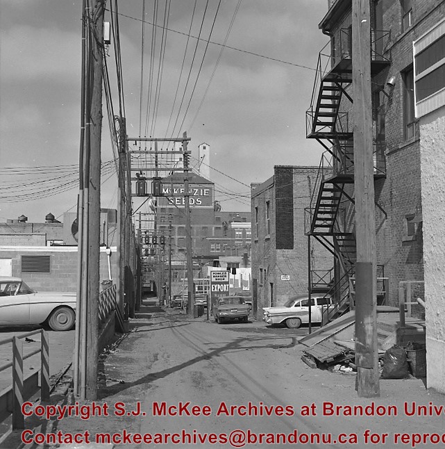
.jpg%3fmaxheight%3d1000%26maxwidth%3d1000%26watermark%3dwmk&description=Back+lane+between+Eighth+Street+and+Ninth+Street)
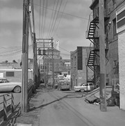
.jpg%3fmaxheight%3d1000%26maxwidth%3d1000%26watermark%3dwmk&description=Back+lane+between+Eighth+Street+and+Ninth+Street)
.jpg%3fmaxheight%3d1000%26maxwidth%3d1000%26watermark%3dwmk&description=Back+lane+between+Eighth+Street+and+Ninth+Street)
.jpg%3fmaxheight%3d1000%26maxwidth%3d1000%26watermark%3dwmk&description=Back+lane+between+Eighth+Street+and+Ninth+Street)