Kirkham's Bridge was built in 1906, to replace an earlier wooden bridge. The bridge was used until 1981, when it was purchased by the Town of Birtle and moved to a newsite. A former railway pridge was installed in its place.
Scope and Content
Photograph shows Kirkham's Bridge, a steel truss bridge that spanned the Little Saskatchewan River in the Municipality of Riverdale.
Notes
Identification of the bridge provided by Ken Storie (2023). Additional information taken from the Manitoba Historical Society website.
Some damage to matting, especially on the back. Photograph is good. There are two brads in the matting (one on the left edge, one on the right edge). The brads are connected to a (broken) red ribbon likely used to hang the photograph.
Custodial History
Kay Sullivan gave the photograph to Fred McGuinness in August 2007.
Scope and Content
Photograph was taken from the riverbank and shows the steel bridge in Souris, MB. A second wooden bridge is visible behind the steel bridge. The residence of Dr. W.A. Sherrin can be seen to the right of the bridges.
Notes
Dr. Sherrin's residence was identified using the Illustrated Souvenir of Souris, Manitoba (p. 38).
Photograph shows the CPR Train Station on Pacific Avenue and 10th Street.
Notes
Part of "Souvenir of Brandon, Manitoba, Canada [viewbook], Printed by Photogelatine Engraving Co. Limited, Ottawa." Dates obtained from the Burchill's Music Store Henderson's Brandon City Directory listings (1927-1929). Writing on the front of the photograph reads: CPR Station, Brandon, Man.
Some damage to matting, especially on the back. There is also significant water damage to the image. There are two brads in the matting (one on the left edge, one on the right edge). The brads are connected to a red ribbon likely used to hang the photograph.
Custodial History
Kay Sullivan gave the photograph to Fred McGuinness in August 2007.
Scope and Content
Photograph was taken from the riverbank and shows the suspension foot-bridge in Souris, MB. A number of buildings, both commerial and possibly residential, can be seen on the far side of the river.
Photograph shows the train station at the port of Mulgrave, Nova Scotia. Possibly the site where the HMCS Alachasse was docked when Fred McGuinness was a telegraphers in the Canadian Navy.
Notes
Writing on the back of the postcard reads: AZO post card
Brient was a point along the Algoma Central Railway line that connected the Helen Mine to the Michipicoten Harbour. It is located southwest of Wawa, Ontario.
Scope and Content
Photograph shows several men standing on railway tracks before a wood-framed train station in the winter. A sign attached to the station reads: British American Express Co. The man in the foreground appears to have a mailbag over on his back and several newspapers tucked beneath his arm.
Notes
Writing beneath the photograph in the album reads: station at Brient
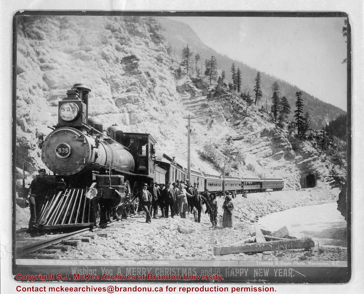
Photograph shows a possible CPR train stopped on the tracks at the base of a mountain. Train employees and passengers are posing alongside the train.
Notes
Writing on the front of the photograph reads: Train #1033 "Pacific Express" in Kicking Horse Pass near Golden / Trueman & Caple Photo, Vancouver, BC / Wishing You A Merry Christmas and a Happy New Year
Date obtained from Margery Hadley McDougall, "R.H. Trueman, Artist and Documentarian," BC Studies, No. 52, Winter 1981-82, pp.129-141.
According to Russ Gourluck (Silver Screens on the Prairie, Winnipeg: Great Plains Publications, 2012, 26), the Orpheum Theatre was in operation from 1917 to 1920 when it then became the Willis Theatre.
Scope and Content
Postcard shows the 100 block of 10th Street facing north. The CPR train station can be seen at the end of 10th Street. The sign for the Rex Cafe is visible on the west side of 10th Street. On the east side of 10th Street, billboards for Campbell & Campbell furniture are visible as well as signs for Pianos and the Orpheum Theatre. Motorists and cyclists share the road. Street car tracks run the length of 10th Street.
Notes
Postcard was manufactured by T.B. [Tichnor Brothers, Inc., 1908-1987] Cambridge, Massachusetts.
Photograph shows a southwest view of the Prince Edward Hotel and train station.
Notes
Part of "Souvenir of Brandon, Manitoba, Canada [viewbook], Printed by Photogelatine Engraving Co. Limited, Ottawa." Dates obtained from the Burchill's Music Store Henderson's Brandon City Directory listings (1927-1929). Writing on the front of the photograph reads: Prince Edward Hotel, Brandon, Man.
Brient was a point along the Algoma Central Railway line that connected the Helen Mine to the Michipicoten Harbour. It is located southwest of Wawa, Ontario.
Scope and Content
Photograph shows ore box cars in a railway yard.
Notes
Writing beneath the photograph in the album reads: yard at Brient
Trembley was a point along the Algoma Central Railway line that connected the Helen Mine to the Michipicoten Harbour. It is located southwest of Wawa, Ontario.
Scope and Content
Photograph shows railroad tracks. A line of ore cars stretch along one track. Writing on the side of one of the cars (#3017) reads: Algoma Central Railway Co.
Notes
Writing beneath the photograph in the album reads: Trembley - Ore Cars
Photograph shows a panorama, bird's-eye-view of downtown Brandon, between Pacific and Rosser Avenues and 7th Street facing east. Photoraph likely taken from the McKenzie Seeds Building. Visible businesses include: Western Canada Flour Mills, Hanbury Hardware Co. Ltd., Cockshutt Plow Co., New Pacific Hotel, Gordon McKay Building, and Arlington Hotel.
Notes
Part of "Souvenir of Brandon, Manitoba, Canada [viewbook], Printed by Photogelatine Engraving Co. Limited, Ottawa." Dates obtained from the Burchill's Music Store Henderson's Brandon City Directory listings (1927-1929). Writing on the front of the photograph reads: Panorama of Brandon, Man.
In 1901, American entrepreneur Francis Hector Clergue (1856-1939) obtained the charter for the Ontario, Hudson Bay and Western Railway. Following his purchase, he reincoporated the Algoma Central Railway to the Algoma Central and Hudson's Bay Railway. (Source: Sault St. Mairie Public Library, "Transportation - Algoma Central Railway," Sault History Online, 2008)
Scope and Content
Photograph shows railroad tracks cutting through the Canadian Shield.
Notes
Writing beneath the photograph in the album reads: Algoma Central & Hundson Bay Ry.
The Lake Talbot tresle was a point along the Algoma Central Railway line that connected the Helen Mine to the Michipicoten Harbour. It is located north of Wawa and southwest of the Helen Mine.
Scope and Content
Photograph shows several men walking a railway line. Before them is a tresle bridge.
Notes
Writing beneath the photograph in the album reads: Lake Talbott Tresle [sic.]
Photograph shows the 800 block of Rosser Avenue facing west. On the south side of Rosser Avenue the Nation Block, Christie's Bookstore, and Reesor's Clock can be seen. A number of horse and buggies/carriages are travelling along Rosser Avenue.
Postcard shows a street scene of Donald Street looking south from the Portage Avenue Intersection.
Notes
Writing on the back of the postcard reads: Aug 9, Dear ruth, Aunt Eva, Aunt Annie and Fred were over to the bowlnig greens tonight. Every one fine. Doddy. Postcard is addressed to Ruth McGuinness, 337-17th St., Brandon, Man. Postmarked: Winnipeg 12 PM Aug 10 1927 Man.
Photograph has been glued to a backing board that has warped over time
History / Biographical
On 16 November 1906, Manitoba was hit by a severe winter storm that began that Thursday evening and extended through the weekend. The Brandon Daily Sun ("Storm Extends Over a Large Territory," 17 Nov. 1906, 1) reported that rail and telegraph services had been disrupted, country roads were impassable, and business in town was at a stand still. Following the weekend, the daily reported the blizzard was one of the greatest in recent memory. CPR trains had been caught in drifts by Carberry and an express car had caught fire and was destroyed ("Worst Storm in Many Years," Brandon Daily Sun, 19 Nov. 1906, 1).
Scope and Content
Photograph shows street view of intersection of the 000 block of 8th Street and Rosser Avenue in the winter. Businesses on the east side of 8th Street from Pacific to Rosser Avenues are clearly visible and include: a Lunch Room (likely Aagaard's Lunch Counter), the Hotel Imperial Annex, Liverpool House (a boarding house), R.S. Thompson and Company Real Estate Office (Land Office), a barber shop (likely J. Coulter's), Frank Gowen photography studio. Fleming's Drug Store on the corner of 8th Street and Rosser Avenue has been replaced by the Bank of Hamilton. The Imperial Hotel is visible on the west side of 8th Street. The 8th Street Bridge is visible in the background. Men in winter coats and hats are crossing the street at the intersection. A horse-drawn sleigh is parked on 8th Street.
Notes
Writing on the front of the photograph matting reads: 340, after the storm November 1906. Page appears to be from a photo album. The photograph appears to be taken from the interior of a builing on the southwest corner of 8th Street and Rosser Avenue.


