Skip header and navigation

Revise Search

20 records – page 5 of 1.

John R. Brodie Science Centre flower beds

http://archives.brandonu.ca/en/permalink/descriptions3019
Part Of
Brandon University Photograph collection
Description Level
Item
GMD
graphic
Date Range
May 1978
Part Of
Brandon University Photograph collection
Description Level
Item
Series Number
2.1
Item Number
BUPC 2.1.40
GMD
graphic
Date Range
May 1978
Physical Description
5" x 3.5"
Scope and Content
Photograph shows a number of the flower beds located on the north side of the John R. Brodie Science Centre.
Subject Access
campus photographs
Show Less

John R. Brodie Science Centre flower beds

http://archives.brandonu.ca/en/permalink/descriptions3026
Part Of
Brandon University Photograph collection
Description Level
Item
GMD
graphic
Date Range
May 1978
Part Of
Brandon University Photograph collection
Description Level
Item
Series Number
2.1
Item Number
BUPC 2.1.42
GMD
graphic
Date Range
May 1978
Physical Description
5" x 3.5" (colour)
Scope and Content
Photograph shows a number of flower beds located on the north side of the John R. Brodie Science Centre.
Subject Access
campus photographs
Images
Show Less

John R. Brodie Science Centre cornerstone laying

http://archives.brandonu.ca/en/permalink/descriptions692
Part Of
John R. Brodie Science Centre
Description Level
Item
GMD
graphic
Date Range
July 12th, 1970
Part Of
John R. Brodie Science Centre
Description Level
Item
Series Number
2.9
Item Number
2.9.7
GMD
graphic
Date Range
July 12th, 1970
Physical Description
5" x 7" (b/w)
Scope and Content
Photograph shows Chancellor Stanley Knowles with Her Majesty Queen Elizabeth II, followed by Hon. James Richardson, Princess Anne and Dr. A.L. Dulmage (President of Brandon University) walking to the cornerstone laying of the John R. Brodie Science Centre.
Show Less

John R. Brodie Science Centre cornerstone laying

http://archives.brandonu.ca/en/permalink/descriptions693
Part Of
John R. Brodie Science Centre
Description Level
Item
GMD
graphic
Date Range
July 12th, 1970
Part Of
John R. Brodie Science Centre
Description Level
Item
Series Number
2.9
Item Number
2.9.8
GMD
graphic
Date Range
July 12th, 1970
Physical Description
5" x 7" (b/w)
Scope and Content
Photograph shows A.L. Dulmage (President of Brandon University) presenting a ceremonial trowel to Queen Elizabeth II at the cornerstone laying ceremony for the John R. Brodie Science Centre. Prince Phillip looks on.
Show Less

John R. Brodie Science Centre cornerstone laying

http://archives.brandonu.ca/en/permalink/descriptions694
Part Of
John R. Brodie Science Centre
Description Level
Item
GMD
graphic
Date Range
July 12th, 1970
Part Of
John R. Brodie Science Centre
Description Level
Item
Series Number
2.9
Item Number
2.9.9
GMD
graphic
Date Range
July 12th, 1970
Physical Description
5" x 7" (b/w)
Scope and Content
Photograph shows Queen Elizabeth, A.L. Dulmage (Brandon University President), Prince Phillip and Princess Anne just after the ceremonial trowle presentation at the cornerstone laying ceremony of the John R. Brodie Science Centre.
Show Less

John R. Brodie Science Centre cornerstone laying

http://archives.brandonu.ca/en/permalink/descriptions697
Part Of
John R. Brodie Science Centre
Description Level
Item
GMD
graphic
Date Range
July 12th, 1970
Part Of
John R. Brodie Science Centre
Description Level
Item
Series Number
2.9
Item Number
2.9.12
GMD
graphic
Date Range
July 12th, 1970
Physical Description
5" x 7" (b/w)
Scope and Content
Photograph shows dignitaries and onlookers on the front lawn in front the the Original Brandon College Building on the day of the cornerstone laying ceremony for the John R. Brodie Science Centre. Visible dignitaries include: H.R.H. Prince Charles (facing crowd), band leader Dr. Merton Utgaard? (from North Dakota), H.R.H. Princess Anne (dark hat), Dr. A.L. Dulmage Brandon University President), Stanley Knowles, and the Hon. James Richardson (M.P. Wpg South, Cabinet Member). Clark Hall and part of the Education Building are visible in the background.
Show Less

John R. Brodie Science Centre loading ramp

http://archives.brandonu.ca/en/permalink/descriptions698
Part Of
John R. Brodie Science Centre
Description Level
Item
GMD
graphic
Date Range
c. 1970s
Part Of
John R. Brodie Science Centre
Description Level
Item
Series Number
2.9
Item Number
2.9.17
GMD
graphic
Date Range
c. 1970s
Physical Description
6.75" x 8" (b/w)
Scope and Content
Photograph is looking down the loading ramp of the John R. Brodie Science Centre. The entrance to the ramp is off Louise Avenue on the south side fo the building.
Show Less

John R. Brodie Science Centre loading ramp

http://archives.brandonu.ca/en/permalink/descriptions699
Part Of
John R. Brodie Science Centre
Description Level
Item
GMD
graphic
Date Range
c. 1970s
Part Of
John R. Brodie Science Centre
Description Level
Item
Series Number
2.9
Item Number
2.9.18
GMD
graphic
Date Range
c. 1970s
Physical Description
6.75" x 8" (b/w)
Scope and Content
Photograph is looking up the loading ramp of the John R. Brodie Science Centre. The entrance to the ramp is off of Louise Avenue.
Show Less

John R. Brodie Science Centre contact prints

http://archives.brandonu.ca/en/permalink/descriptions700
Part Of
John R. Brodie Science Centre
Description Level
Item
GMD
graphic
Date Range
c. 1971/72
Part Of
John R. Brodie Science Centre
Description Level
Item
Series Number
2.9
Item Number
2.9.13
GMD
graphic
Date Range
c. 1971/72
Physical Description
6.75" x 2.75" (b/w)
Scope and Content
Item consists of three contact prints (approximately 1.5" x 1") of the John R. Brodie Science Centre. All of the images are looking south and show the north side of the Brodie Building as well as the hedge along the sidewalk on 18th Street and part of McMaster Hall.
Show Less

Display case in the John R. Brodie Science Centre

http://archives.brandonu.ca/en/permalink/descriptions775
Part Of
John R. Brodie Science Centre
Description Level
Item
GMD
graphic
Date Range
1982
Part Of
John R. Brodie Science Centre
Description Level
Item
Series Number
2.9
Item Number
2.9.3
GMD
graphic
Date Range
1982
Physical Description
5" x 8" (b/w)
Scope and Content
Photograph shows the display case in the John R. Brodie Science Centre. The Citizens' Science Centre is visible through the window.
Show Less

Display case in the John R. Brodie Science Centre

http://archives.brandonu.ca/en/permalink/descriptions777
Part Of
John R. Brodie Science Centre
Description Level
Item
GMD
graphic
Date Range
1982
Part Of
John R. Brodie Science Centre
Description Level
Item
Series Number
2.9
Item Number
2.9.4
GMD
graphic
Date Range
1982
Physical Description
5" x 8" (b/w)
Scope and Content
Photograph shows the display case in the John R. Brodie Science Centre. A portion of 18th Street is visible through the glass.
Show Less

John R. Brodie Science Centre and McMaster Hall construction

http://archives.brandonu.ca/en/permalink/descriptions684
Part Of
John R. Brodie Science Centre
Description Level
Item
GMD
graphic
Date Range
c. 1969-1970
Part Of
John R. Brodie Science Centre
Description Level
Item
Series Number
2.9
Item Number
2.9.15
GMD
graphic
Date Range
c. 1969-1970
Physical Description
8.5" x 10" (b/w)
Physical Condition
There are some areas of discoloration on the back of the photograph, which has led to some brown spots on the image.
Scope and Content
Photograph is looking southeast and shows the excavated area where the John R. Brodie Science Centre and McMaster Hall were constructed.
Show Less

John R. Brodie Science Centre and McMaster Hall gardens

http://archives.brandonu.ca/en/permalink/descriptions719
Part Of
John R. Brodie Science Centre
Description Level
Item
GMD
graphic
Date Range
c. 1971
Part Of
John R. Brodie Science Centre
Description Level
Item
Series Number
2.9
Item Number
2.9.14
GMD
graphic
Date Range
c. 1971
Physical Description
1.5" x 8" (b/w)
Material Details
TRIX PAN FILM
Scope and Content
Item is a contact print that is looking east and was taken from McMaster Hall. Image shows the McMaster Hall gardens under construction and the north side of the John R. Brodie Science Centre.
Show Less

John R. Brodie Memorial Science Centre, Brandon University

http://archives.brandonu.ca/en/permalink/descriptions11671
Part Of
CKX fonds
Description Level
Item
GMD
graphic
Date Range
1969
Accession Number
11-2010
Part Of
CKX fonds
Creator
CKX
Description Level
Item
Item Number
11-2010.B130
Accession Number
11-2010
GMD
graphic
Date Range
1969
Physical Description
5" x 4" (b/w)
Material Details
Negative
Custodial History
See fonds level of the CKX records for custodial history.
Scope and Content
Image of an architectural drawing for the proposed John R. Brodie Memorial Science Centre at Brandon University.
Name Access
CKX Television
Brandon College
Subject Access
universities
Storage Location
CKX fonds - 2010 accessions
Images
Show Less

Aerial view: John R. Brodie Science Centre roof greenhouse

http://archives.brandonu.ca/en/permalink/descriptions608
Part Of
Aerial views and campus photographs
Description Level
Item
GMD
graphic
Date Range
c. 1970s
Part Of
Aerial views and campus photographs
Description Level
Item
Series Number
2.1
Item Number
2.1.15
GMD
graphic
Date Range
c. 1970s
Physical Description
8" x 10" (b/w)
Scope and Content
View is southeast and was probably taken from the roof of McMaster Hall. Photograph shows the greenhouse situated on top of the John R. Brodie Science Centre.
Images
Show Less

Architectural drawing of the John R. Brodie Science Centre and student residence

http://archives.brandonu.ca/en/permalink/descriptions689
Part Of
John R. Brodie Science Centre
Description Level
Item
GMD
graphic
Date Range
c. 1970
Part Of
John R. Brodie Science Centre
Creator
Drawing by: Green Blankstein Russell Associates - Architects & Engineers, Winnipeg, MB.
Description Level
Item
Series Number
2.9
Item Number
2.9.16
GMD
graphic
Date Range
c. 1970
Physical Description
8" x 10" (b/w)
Scope and Content
Item is an architectural drawing of the proposed John R. Brodie Science Centre and student residence at Brandon University.
Show Less

Lawrence Stuckey slide collection

http://archives.brandonu.ca/en/permalink/descriptions9512
Part Of
RG 11 Lawrence Stuckey fonds
Description Level
Series
GMD
graphic
Date Range
1954-1982
Accession Number
1-2002
Part Of
RG 11 Lawrence Stuckey fonds
Description Level
Series
Series Number
2
Accession Number
1-2002
GMD
graphic
Date Range
1954-1982
Physical Description
approximately 3838 colour slides
History / Biographical
For history/bio information see the collection level description of the Lawrence Stuckey collection.
Custodial History
For custodial history see the collection level description of the Lawrence Stuckey collection.
Scope and Content
Series consists of slides created from photographs taken by Lawrence Stuckey during his travels throughout Manitoba, other parts of Canada and the United States. Although Lawrence and his wife Mavis travelled for pleasure, their destinations were often chosen deliberately to enable Lawrence to explore and photograph specific landscapes, flora and fauna.
Name Access
Glendenning
Assiniboine River
Souris River
Sidney
Manitoba
Whiteshell
Carberry Hills
Baldhead Hills
Sprucewoods
Duck Mountains
Rossburn
Thompson
Kelsey Trail
E.T. Seton Park
Steeprock Bay
Steeprock River
Flin Flon
Rocky Lake
Lake Winnipegosis
Turtle Mountains
Riding Mountain National Park
Moon Lake
Lake Katherine
Clear Lake
Arrowhead Trail
B&B Trail
Ominik Trail
Gorge Creek
Scarborough
Ontario
Edwards Gardens
Royal Botanical Gardens
Prince Albert
Saskatoon
Lake Madge
Winnipeg
Saskatchewan
International Peace Gardens
South Dakota
Black Hills
North Dakota
Quebec
Kenora
Qu'Appelle Valley
Theodore Roosevelt National Monument
Toronto
Point Pelee
Port Dover
Windsor
Yellowstone National Park
Wyoming
Ottawa
Scotsbluff
Nebraska
Mt. Evans Road
Colorado
Berthoud Pass
Milner Pass
Dinosaur Park
Trail Ridge
Rollins Pass
Grand Teton
Beartooth Pass
Craters of the Moon
Idaho
Medicine Bow National Fort
Michigan
Wisconsin
Quebec City
Mont. Tremblant Park
Sugar Camp
Satine-Anne-de-Bellevue Canal
Montreal
Banff National Park
Larch Valley
Sentinel Pass
Lake Louise
Moraine Lake
Athabaska River
Plain of Six
Columbia Icefields
Bow River
Victoria Glacier
Yoho Pass
Yoho National Park
Wapta Falls
Hoodoo Park
Waterfall Valley
Highline Trail
Burgess Pass
Takakaw Falls
Kicking Horse
Skyline Trail
Waterton Lakes National Park
Emerald Lake
Yoho Valley
Twin Falls Creek
Trans Canada Highway
Subject Access
geographic features
manmade geographic features
natural geographic features
political geographic features
natural phenomena
natural waterways
bridges
canals
mines
roads
trails
monuments
historical markers
lakes
mountains
national parks
parks
hills
valleys
Rivers
cities
towns
landscapes
creeks
gardens
Plants
trees
badlands
glaciers
icefields
hoodoos
waterfalls
beaches
forests
Accruals
Additional slides of flora and fauna taken by Stuckey during his travels are housed in the McKee Archives. Those slides are unprocessed at present.
Repro Restriction
The McKee Archives is the copyright holder for the Stuckey materials.
Storage Location
Lawrence Stuckey collection
Show Less

Central United Church - After Fire

http://archives.brandonu.ca/en/permalink/descriptions9624
Part Of
RG 11 Lawrence Stuckey fonds
Description Level
Item
GMD
graphic
Date Range
June 26, 1986
Accession Number
1-2002
Part Of
RG 11 Lawrence Stuckey fonds
Creator
L.A. Stuckey
Description Level
Item
Series Number
3.1
Item Number
1-2002.3.1FA11(1)
Accession Number
1-2002
GMD
graphic
Date Range
June 26, 1986
Physical Description
2 1/2" x 2 1/2"
Material Details
Negative
History / Biographical
Designed by architect Walter Shillinglaw; Built in 1900 and opened January of 1901 as St. Paul's Presbyterian Church at a cost of $35,000.
Became St. Paul's United Church in 1925; In 1969 congregation amalgamated with First United to become Central United Church.
Struck by lightening 3:09 AM June 26, 1986 and gutted by fire.
Custodial History
For custodial history see the collection level description of the Lawrence Stuckey collection.
Scope and Content
View of Central United Church after it was gutted by fire
Notes
[Mr. Stuckey put two negatives in same envelope. We have separated them and numbered them FA11(1) and FA11(2).]
Name Access
Central United Church - After Fire
Subject Access
fires
Brandon Churches
Brandon Fires
Repro Restriction
The McKee Archives is the copyright holder for the Stuckey materials.
Storage Location
Lawrence Stuckey collection
Images
Show Less

Central United Church - After Fire

http://archives.brandonu.ca/en/permalink/descriptions9625
Part Of
RG 11 Lawrence Stuckey fonds
Description Level
Item
GMD
graphic
Date Range
June 26, 1986
Accession Number
1-2002
Part Of
RG 11 Lawrence Stuckey fonds
Creator
L.A. Stuckey
Description Level
Item
Series Number
3.1
Item Number
1-2002.3.1FA11(2)
Accession Number
1-2002
GMD
graphic
Date Range
June 26, 1986
Physical Description
2 1/2" x 2 1/2"
Material Details
Negative
History / Biographical
Designed by architect Walter Shillinglaw; Built in 1900 and opened January of 1901 as St. Paul's Presbyterian Church at a cost of $35,000.
Became St. Paul's United Church in 1925; In 1969 congregation amalgamated with First United to become Central United Church.
Struck by lightening 3:09 AM June 26, 1986 and gutted by fire.
Custodial History
For custodial history see the collection level description of the Lawrence Stuckey collection.
Scope and Content
View of Central United Church after it was gutted by fire
Notes
[Mr. Stuckey put two negatives in same envelope. We have separated them and numbered them FA11(1) and FA11(2).]
Name Access
Central United Church - After Fire
Subject Access
fires
Brandon Churches
Brandon Fires
Repro Restriction
The McKee Archives is the copyright holder for the Stuckey materials.
Storage Location
Lawrence Stuckey collection
Images
Show Less

Belvidere Apartments

http://archives.brandonu.ca/en/permalink/descriptions9405
Part Of
RG 11 Lawrence Stuckey fonds
Description Level
Item
GMD
graphic
Date Range
January 2, 1978
Accession Number
1-2002
Part Of
RG 11 Lawrence Stuckey fonds
Creator
L.A. Stuckey
Description Level
Item
Series Number
3.1
Item Number
1-2002.3.1DC5
Accession Number
1-2002
GMD
graphic
Date Range
January 2, 1978
Physical Description
2 1/2" x 2 1/2"
Material Details
Negative
History / Biographical
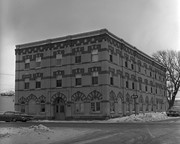
Building was built as the Reno Hotel in 1910, the city's best; was soon overshadowed by Canadian Northern Railway's Prince Edward Hotel in 1912; Became Belvidere Apts. 1918
This is the only building, apart from houses, completely faced with "Samson's" brick from Brandon Sand & Brick Co. (plant at 30th St. & Princess Ave - presently playground of Valleyview School) to survive into the 1980's. Ornamentation around door and windows is the only surviving example of their red dyed brick, known.
Custodial History
For custodial history see the collection level description of the Lawrence Stuckey collection.
Scope and Content
Belvidere Apartments (ex. Reno Hotel), 1280 Rosser Ave.
Notes
[Mr. Stuckey put two negatives (DC5 and DC5a) in same envelope, which we have separated, along with a print we numbered DC5(b).]
Name Access
Belvidere Apartments
Subject Access
apartment buildings
hotels
Brandon hotels
Brandon apartment buildings
Repro Restriction
The McKee Archives is the copyright holder for the Stuckey materials.
Storage Location
Lawrence Stuckey collection
Images
Show Less

20 records – page 5 of 1.