Photograph shows the Red Indian (Gasoline) Station on the north side Princess Avenue between 9th and 10th Streets, Brandon. Attached to the west side of the gas station is another shop which contains Hutchings' Drug Store. The Alexandra Block on 10th Street is visible in the background.
Left hand corner of mat is bent. Mock-up instructions are written in pencil at the bottom right hand corner. Portions of the photograph itself are marked with pen.
History / Biographical
The Queen's Hotel was located on the corner of Rosser Avenue and Tenth Street (Steen & Boyce, 1882. Brandon, Manitoba, Canada and Her Industries. Steen & Boyce Publishers Printers & Binders, 81.). Therefore this photo appears to display Rosser Avenue looking east. P.E. 11/06/09
Scope and Content
Photograph shows early Rosser Avenue under construction between 9th Street and 10th Street in the 1880s. Buildings that line the avenue are wood framed and there are wooden boardwalks in front of a few structures. On the north side of Rosser Avenue signs for Fortier & Bucke Commision Agents and Transit House (Hotel) can be seen. On the south side of Rosser Avenue, the Queen's Hotel and Robinson Brothers and Company groceries and dry goods store are open for business. A family appears to be standing on the stoop at the dry goods store. A boy is lounging in the entryway of the Queen's Hotel. A man is standing on a wooden plank that extends across the dirt road of Rosser Avenue between the dry goods store and the commission agents' shop.
Photograph shows the intersection, facing northwest, at 10th Street and Princess Avenue, Brandon, Manitoba. Fitwell Tailors can be seen on the south side of Princess Avenue. Doig's Home Furnishings and The Manufactuerers Life can be seen on the northwest corner. Traffic appears to be travelling both ways on Princess Avenue.
Photograph shows the construction of the McGuinness home in a new housing development in Medicine Hat, 492 6th Street Northeast. Aerial view shows that neighbouring blocks have yet to be constructed.
Photograph shows the McGuinness home in a new housing development in Medicine Hat, 492 6th Street Northeast. Aerial view shows that neighbouring blocks have yet to be constructed and the backyard to the McGuinness home is completed.
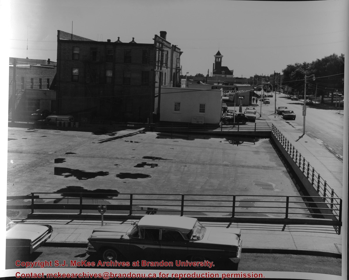
Photograph shows the northeast corner of 10th Street and Princess Avenue facing east. In the background the following Brandon businesses can be seen: back of the Brandon Inn, B/A gas station, The Princess Cafe, and the Central Fire Hall.
Notes
Photograph dated from "Tara's Bulba," the movie playing at the Strand Theatre and similiar vehicles captured in the photograph.
Photograph shows Western Motors Ltd. on the southwest corner of 10th Street and Princess Avenue. To the west of the car dealership/garage is the Greyhound Bus Station and its Maxwell House Cafe as well as the court house.
Photograph shows the Brandon Wheat Market along Pacific Avenue on November 30, 1885. Farmers can be seen driving wagon teams loaded with bags of grain in line on Pacific Avenue from 10 Street to at least 7th Street. On the north side of Pacific Avenue the CPR Land Office and grain elevators are pictured. On the south side of Pacific Avenue, the general merchant/hardware store Bower, Blackburn, Mundell & Porter is situated on the corner of Pacific Avenue and 10th Street. A 10th Street sign is affixed to the merchants' store. On the east side of the general store, Edie House, the Grand View Hotel, and a Farmers' boarding and lodging house can be seen. Most of the buildings appear to be woodframed except for the Grand View, which is constructed of brick. Sidewalks appear to be in place on the south side of Pacific and snow dusts the streets. A baby swathed in winter clothing sits in a pram/baby carriage in front of the general store.
Notes
Writing on the front of the photograph reads: Novemeber 30th, 1885, Brandon Wheat Market
Photograph shows the northeast corner of 10th Street and Princess Avenue. OK Used Cars - Western Motors Ltds - used car lot and a building containing The Specialty Shop and another business are pictured. The exposed wall of the Brown Block has been painted over.
Photograph shows the Greyhound Bus Depot at 11th Street and Princess Avenue. Western Motors, Wheelers Esso Station, and the Prince Edward Hotel are visible along the south side of Princess Avenue. Traffic is travelling one-way on Princess Avenue.
The Royal Bank moved to this location on 26 October 1929. An existing building was renovated to accomodate the bank. On 28 May 1976 fire destroyed the buildings from the lane west to the Royal Bank.
Scope and Content
Photograph shows the south side of Rosser Avenue between 7th and 8th Streets, west of the Eaton's building. Visible shops include: Vogue [Ladies Wear], Smith's Drugs, Sobie's Tailored Undergarnments, Household Finance Loans, and The Royal Bank of Canada.
Photograph shows a street view of 10th Street facing north. There are many automobiles parked along the street and several pedestrians in summer dress are on the sidewalks and street. Visible business signs include: Hentzman & Co. Pianos (possibly belonging to J.J.H. McLean Co. Ltd.), the Strand Theatre, T & D Clothes, Campbell & Campbell, the CPR Station, and Bowling Alley and Billiards.
Notes
Part of "Souvenir of Brandon, Manitoba, Canada [viewbook], Printed by Photogelatine Engraving Co. Limited, Ottawa." Dates obtained from the Burchill's Music Store Henderson's Brandon City Directory listings (1927-1929). Writing on the front of the photograph reads: 10th St., looking north (C.P.R. Station at end of Street) Brandon, Man.
Corners of photograph mat are bent. Picture is cracked.
Scope and Content
Photograph shows an early view of Brandon's 6th Street in the 1880s. The Winter & O'Neail Groceries & Provisions and James Smart Hardware storefronts have been photographed. A street sign designating 6th Street can be seen below the Winter & O'Neail sign. A horse and cart is parked in front of the grocery store. A number of men wearing hats and jackets are standing along the boardwalk while posing for the picture. Lumber/timber saws are displayed in teh windows of the hardware store.
Notes
Front of photograph reads: 6th Street, Brandon, Manitoba, 1881-1882, Entrance [to Winter & O'Neail] corner of Rosser Ave & 6th Street.
The Brandon Daily Sun (26 May 1924, 16) reported the annual church parade of Brandon Lodge 173 Sons of England was held on Sunday, May 25, 1924. The Brandon City Band lead the parade with H.J. Barter, P.P., serving as parade marshal. Over 100 members paraded to St. Mary's Church. Representatives from a variety of lodges participated, including Alexander, Neepawa, Souris, Wawanesa, and Lodge Carpenter Juveniles.
Scope and Content
Photograph shows a parade travelling southwards on 10th Street between Rosser and Princess Avenues. A mounted rider wearing white appears to be leading the parade. A car draped with American and British flags follows. A band follows the vehicle. Individuals wearing white hats walk up the street.
Business visible on the west side (100-block) of 10th Street include: Doig, Rankin, & Robertson, Limited; Bowling Alley, Billiards; Olympia Cafe Candies. The second storey on the Hughes Building has not been erected. The Alexandra Block, Strathcona Block, Olympia Block are visible. A large Union Jack flys from the Canadian Pacific Station. Vehicles are diagonally parked on both sides of 10th Street.
Notes
Back of photograph is stamped: Hughes & Co. Ltd., 1009 Princess Ave., Brandon, Man. Date for photograph obtained from licence plates.
Photograph shows the 700-block of Rosser Avenue facing west. Visible businesses on the north side of Rosser Avenue include: Burchill's Music Store, E.W. Woolworth Co. Ltd. 5-10 and 15 Cent Store in the E.E. Evans Block, Empire Hotel, and W.A. Paterson Drugs. Automobiles are parked on both sides of the avenue and at the time the photograph was taken, Rosser Avenue was a two-way street.
Notes
Part of "Souvenir of Brandon, Manitoba, Canada [viewbook], Printed by Photogelatine Engraving Co. Limited, Ottawa." Dates obtained from the Burchill's Music Store Henderson's Brandon City Directory listings (1927-1929). Writing on the front of the photograph reads: Rosser St. [sic.] - Brandon, Man.
Photograph shows the west side of the 100-block of 10th Street facing northwest. Visible businesses include: Bottomley's Furniture, Recreation Bowling & Billiards, Fashion Fabrics, Brandon News & Record Shop, Bass' Storkland, Beneficial Finance Co., and the Kresge Store. The Johnny Smith Block is visible in the background.
Photograph shows the southeast corner of 10th Street and Rosser Avenue, Brandon, Manitoba. The Bank of Montreal is situated on the corner. Visible businesses along the east side of 10th Street include: Barclay's Shoe Store, Carlton Cafe, and Ted Heming Jewellers.
Postcard shows a street scene of Donald Street looking south from the Portage Avenue Intersection.
Notes
Writing on the back of the postcard reads: Aug 9, Dear ruth, Aunt Eva, Aunt Annie and Fred were over to the bowlnig greens tonight. Every one fine. Doddy. Postcard is addressed to Ruth McGuinness, 337-17th St., Brandon, Man. Postmarked: Winnipeg 12 PM Aug 10 1927 Man.
The Medicine Hat Exhibition and Stampede Parade Day was held on Thursday, July 19, 1962, at 9:30 a.m. The local newspaper reported that approximately 24,000 people were in attendance to see parade marshall Rod Ashburner leading 175 entries consisting of 90 floats, 75 horses, and 10 bands. There were 19 parade categories eligible for $12,000 in prize money and included: junior and senior cowboys and cowgirls; fancy and Shetland ponies; sulky class open; comic, commercial, industrial and organizational floats; decorated cars; special ranch class; 4-H Clubs; and a non-competitive class.
The parade route started at Second St. and Allowance Ave., from Second St. to Ash Ave., north on Ash to First St. SE., from First St. S.E. to Fourth Ave., south to Second St. to South Railway St., south on South Railway St. to Third St., with a finish at McLeod Trail. A route map was published in the Medicine Hat News the day before the parade.
Aerial photographs of the parade were taken by Medicine Hat News photographer Howard Heid (1930-2005) from the private helicopter of John Bourn. Bourn was a pilot from Woodville, Wisconsin, who chartered his four-seater helicopter for sight-seers at exhibitions and stampedes across the county.
(Sources: Pat Currie, "Let 'Er Go!," Medicine Hat News, 19 July 1962,1; Harald Gunderson, "'Eye in the Sky' Best Parade View," Medicine Hat News, 19 July 1962,1; "Parade Starts at 9:30 Sharp," 18 July 1962)
Scope and Content
Photograph shows an aerial view of the Medicine Hat Exhibition and Stampede Parade route, with a focus on Second Street SE. Visible store signs include: China Wonderland, Grey Cup Cafe, Lane Bros. & Gibson Ltd., Joy's, Marshall's, Monarch, Gardener's Used Cars, Provincial Treasury Branch, Furvey's Furniture and Appliances, J.J. Moore & Son, Club Cafe, Black Hardware Ltd., Regency Billards, and Sair's Shoe Hospital.
The Medicine Hat Exhibition and Stampede Parade Day was held on Thursday, July 19, 1962, at 9:30 a.m. The local newspaper reported that approximately 24,000 people were in attendance to see parade marshall Rod Ashburner leading 175 entries consisting of 90 floats, 75 horses, and 10 bands. There were 19 parade categories eligible for $12,000 in prize money and included: junior and senior cowboys and cowgirls; fancy and Shetland ponies; sulky class open; comic, commercial, industrial and organizational floats; decorated cars; special ranch class; 4-H Clubs; and a non-competitive class.
The parade route started at Second St. and Allowance Ave., from Second St. to Ash Ave., north on Ash to First St. SE., from First St. S.E. to Fourth Ave., south to Second St. to South Railway St., south on South Railway St. to Third St., with a finish at McLeod Trail. A route map was published in the Medicine Hat News the day before the parade.
Aerial photographs of the parade were taken by Medicine Hat News photographer Howard Heid (1930-2005) from the private helicopter of John Bourn. Bourn was a pilot from Woodville, Wisconsin, who chartered his four-seater helicopter for sight-seers at exhibitions and stampedes across the county.
(Sources: Pat Currie, "Let 'Er Go!," Medicine Hat News, 19 July 1962,1; Harald Gunderson, "'Eye in the Sky' Best Parade View," Medicine Hat News, 19 July 1962,1; "Parade Starts at 9:30 Sharp," 18 July 1962)
Scope and Content
Photograph shows an aerial view of the Medicine Hat Exhibition and Stampede Parade route, with a focus on the First Street SE and North Railway Street merge.
Notes
This photograph appeared on the front page of The Medicine Hat News (19 July 1962).


+north+side+Princess+Avenue+between+9th+Street+and+10th+Street%2c+Brandon%2c+Manitoba)
)