Skip header and navigation

Revise Search

20 records – page 1 of 1.

West side 200-block 10th Street facing south from Princess Avenue, Brandon, Manitoba

http://archives.brandonu.ca/en/permalink/descriptions8417
Part Of
Joseph H. Hughes collection
Description Level
Item
GMD
graphic
Date Range
c.1955
Accession Number
3-1997
Part Of
Joseph H. Hughes collection
Description Level
Item
Series Number
3-1997.1
Item Number
3-1997.1.39
Accession Number
3-1997
GMD
graphic
Date Range
c.1955
Physical Description
10" x 8" (b/w)
Physical Condition
good
Scope and Content
Photograph shows the west side of the 200-block on 10th Street. Visible businesses include: Chamber of Commerce Tourist Information, Dominion Tire & Radio Co., Steve's Grill, Wally's Taxi, and the garage entrances to Western Motors Ltd. A Santa Claus Christmas ornament is displayed from a light standard.
Name Access
Chamber of Commerce
Dominion Tire & Radio Co.
Steve's Grill
Wally's Taxi
Western Motors
10th Street
Subject Access
downtowns
street scenes
Brandon business buildings & facilities after 1940
building exteriors
winter
garages
taxi
restaurants
Christmas
Storage Location
RG 5 photograph storage drawer
Images
Show Less

Princess Avenue facing east from 10th Street, Brandon, Manitoba

http://archives.brandonu.ca/en/permalink/descriptions8413
Part Of
Joseph H. Hughes collection
Description Level
Item
GMD
graphic
Date Range
c. 1965
Accession Number
3-1997
Part Of
Joseph H. Hughes collection
Description Level
Item
Series Number
3-1997.1
Item Number
3-1997.1.35
Accession Number
3-1997
GMD
graphic
Date Range
c. 1965
Physical Description
10" x 8" (b/w)
Physical Condition
good
Scope and Content
Photograph shows Princess Avenue facing east from 10th Street. On the north side of Princess Avenue, a B/A Service Station, Princess Cafe, Lindenberg Seeds, and the Central Fire Station are visible. Old City Hall with the war memorial and the Prince Edward Hotel are visible on the south side of Princess Avenue. Traffic is travelling one-way on Princess Avenue.
Name Access
Princess Avenue
City Hall
Prince Edward Hotel
B/A Service Station
Princess Cafe
Lindenberg Seeds
Central Fire Station
Subject Access
downtowns
street scenes
Brandon business buildings & facilities after 1940
building exteriors
hotels
garages
service stations
cafes
memorials
Storage Location
RG 5 photograph storage drawer
Images
Show Less

West side 200-block 10th Street, south of Princess Avenue, Brandon, Manitoba

http://archives.brandonu.ca/en/permalink/descriptions8416
Part Of
Joseph H. Hughes collection
Description Level
Item
GMD
graphic
Date Range
c. 1955
Accession Number
3-1997
Part Of
Joseph H. Hughes collection
Description Level
Item
Series Number
3-1997.1
Item Number
3-1997.1.38
Accession Number
3-1997
GMD
graphic
Date Range
c. 1955
Physical Description
10" x 8" (b/w)
Physical Condition
good
Scope and Content
Photograph shows the west side of the 200-block on 10th Street. Visible businesses include: Chamber of Commerce Tourist Information, Dominion Tire & Radio Co., Bonnie's Bonnet Shop, Steve's Grill, Wally's Taxi, and Western Motors Ltd. The painted advertisement for Doig, Rankin and Robertson is visible on the Alexandra Block. Christmas ornaments are displayed from light standards and include Santa Claus and a Christmas elf.
Name Access
Chamber of Commerce
Dominion Tire & Radio Co.
Bonnie's Bonnet Shop
Steve's Grill
Wally's Taxi
Western Motors
10th Street
Subject Access
downtowns
street scenes
Brandon business buildings & facilities after 1940
building exteriors
winter
garages
taxi
restaurants
Christmas
Storage Location
RG 5 photograph storage drawer
Images
Show Less

Red Indian Station (Gasoline) north side Princess Avenue between 9th Street and 10th Street, Brandon, Manitoba

http://archives.brandonu.ca/en/permalink/descriptions8418
Part Of
Joseph H. Hughes collection
Description Level
Item
GMD
graphic
Date Range
c. 1940
Accession Number
3-1997
Part Of
Joseph H. Hughes collection
Description Level
Item
Series Number
3-1997.1
Item Number
3-1997.1.40
Accession Number
3-1997
GMD
graphic
Date Range
c. 1940
Physical Description
10" x 8" (b/w)
Physical Condition
good
Scope and Content
Photograph shows the Red Indian (Gasoline) Station on the north side Princess Avenue between 9th and 10th Streets, Brandon. Attached to the west side of the gas station is another shop which contains Hutchings' Drug Store. The Alexandra Block on 10th Street is visible in the background.
Name Access
Hutchings Drugs
Red Indian Service Station
Princess Avenue
Subject Access
downtowns
street scenes
Brandon business buildings & facilities after 1940
building exteriors
garages
drug stores
Storage Location
RG 5 photograph storage drawer
Images
Show Less

McGuinness Medicine Hat residence - aerial

http://archives.brandonu.ca/en/permalink/descriptions14115
Part Of
Fred McGuinness collection
Description Level
Item
GMD
graphic
Date Range
[1960-1965]
Accession Number
1-2015
Part Of
Fred McGuinness collection
Description Level
Item
Series Number
McG 9
Item Number
1-2015.184
Accession Number
1-2015
GMD
graphic
Date Range
[1960-1965]
Physical Description
10" x 8" (b/w)
Scope and Content
Photograph shows the construction of the McGuinness home in a new housing development in Medicine Hat, 492 6th Street Northeast. Aerial view shows that neighbouring blocks have yet to be constructed.
Name Access
Fred McGuinness
Frederick George McGuinness
Medicine Hat
Subject Access
residences
street scenes
residential streets
winter
aerial views
aerial photography
Storage Location
RG 5 photograph storage drawer 2 (hanging photos)
Arrangement
BR #3 Family photos
Images
Show Less

McGuinness Medicine Hat residence - winter aerial

http://archives.brandonu.ca/en/permalink/descriptions14116
Part Of
Fred McGuinness collection
Description Level
Item
GMD
graphic
Date Range
[1960-1965]
Accession Number
1-2015
Part Of
Fred McGuinness collection
Description Level
Item
Series Number
McG 9
Item Number
1-2015.185
Accession Number
1-2015
GMD
graphic
Date Range
[1960-1965]
Physical Description
10" x 8" (b/w)
Scope and Content
Photograph shows the McGuinness home in a new housing development in Medicine Hat, 492 6th Street Northeast. Aerial view shows that neighbouring blocks have yet to be constructed and the backyard to the McGuinness home is completed.
Name Access
Fred McGuinness
Frederick George McGuinness
Medicine Hat
Subject Access
residences
street scenes
residential streets
winter
aerial views
aerial photography
Storage Location
RG 5 photograph storage drawer 2 (hanging photos)
Arrangement
BR #3 Family photos
Images
Show Less

Western Motors at southwest corner 10th and Princess Avenue, Brandon, Manitoba

http://archives.brandonu.ca/en/permalink/descriptions8415
Part Of
Joseph H. Hughes collection
Description Level
Item
GMD
graphic
Date Range
c.1955
Accession Number
3-1997
Part Of
Joseph H. Hughes collection
Description Level
Item
Series Number
3-1997.1
Item Number
3-1997.1.37
Accession Number
3-1997
GMD
graphic
Date Range
c.1955
Physical Description
10" x 8" (b/w)
Physical Condition
good
Scope and Content
Photograph shows Western Motors Ltd. on the southwest corner of 10th Street and Princess Avenue. To the west of the car dealership/garage is the Greyhound Bus Station and its Maxwell House Cafe as well as the court house.
Name Access
Greyhound
Western Motors Ltd.
Princess Avenue
Maxwell House Grill
Court House
Subject Access
downtowns
street scenes
Brandon business buildings & facilities after 1940
building exteriors
winter
bus depots
garages
Storage Location
RG 5 photograph storage drawer
Images
Show Less

Greyhound Bus Depot, 11th Street and Princess Avenue, Brandon, Manitoba

http://archives.brandonu.ca/en/permalink/descriptions8414
Part Of
Joseph H. Hughes collection
Description Level
Item
GMD
graphic
Date Range
c.1955
Accession Number
3-1997
Part Of
Joseph H. Hughes collection
Description Level
Item
Series Number
3-1997.1
Item Number
3-1997.1.36
Accession Number
3-1997
GMD
graphic
Date Range
c.1955
Physical Description
10" x 8" (b/w)
Physical Condition
good
Scope and Content
Photograph shows the Greyhound Bus Depot at 11th Street and Princess Avenue. Western Motors, Wheelers Esso Station, and the Prince Edward Hotel are visible along the south side of Princess Avenue. Traffic is travelling one-way on Princess Avenue.
Name Access
Greyhound
Western Motors Ltd.
Esso
Prince Edward Hotel
Princess Avenue
11th Street
Subject Access
downtowns
street scenes
Brandon business buildings & facilities after 1940
building exteriors
hotels
garages
bus depots
Storage Location
RG 5 photograph storage drawer
Images
Show Less

Christmas Tree Farm - aerial view

http://archives.brandonu.ca/en/permalink/descriptions13964
Part Of
Fred McGuinness collection
Description Level
Item
GMD
graphic
Date Range
[2009]
Accession Number
1-2015
Part Of
Fred McGuinness collection
Description Level
Item
Series Number
McG 9
Item Number
1-2015.36
Accession Number
1-2015
GMD
graphic
Date Range
[2009]
Physical Description
11" x 8.5" (colour)
Material Details
reproduction
Scope and Content
Colour photocopy shows an aerial view of the Fred McGuinness property - Christmas Tree Farm - on section 17.
Name Access
Christmas Tree Farm
Subject Access
residences
aerial photographs
farms
Storage Location
McGuinness oversize storage drawer (1-2015)
Arrangement
From RR #3 family letters
Images
Show Less

Lorne Avenue, looking west from St. Augustine's Church postcard

http://archives.brandonu.ca/en/permalink/descriptions13937
Part Of
Fred McGuinness collection
Description Level
Item
GMD
graphic
Date Range
1952
Accession Number
1-2015
Part Of
Fred McGuinness collection
Creator
Photograph by: J.V.
Description Level
Item
Series Number
McG 9
Item Number
1-2015.9
Accession Number
1-2015
GMD
graphic
Date Range
1952
Physical Description
5.5" x 3.5" (colour)
Material Details
postcard
Scope and Content
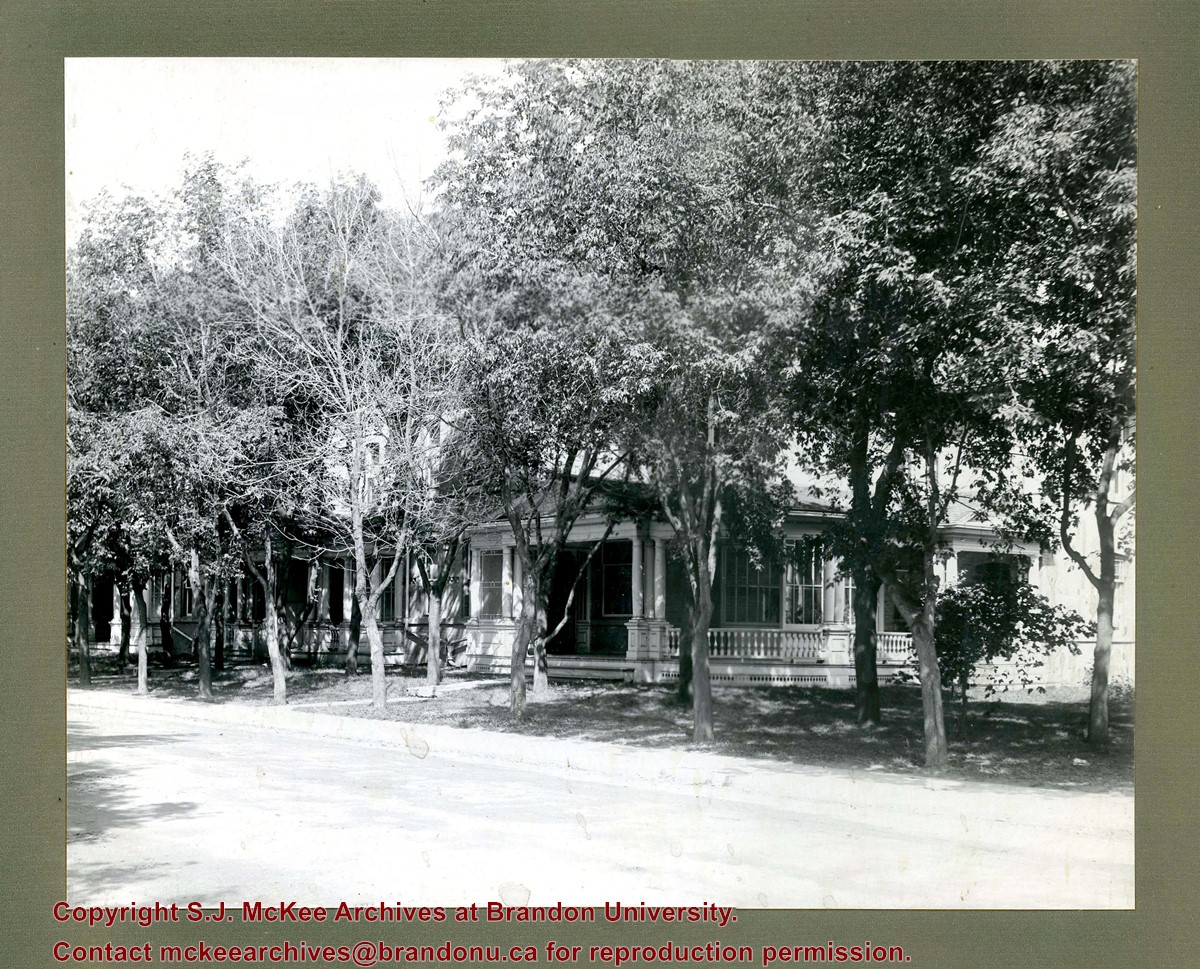
Photograph shows a western view of the residential area along Lorne Avenue from St. Augustine's Roman Catholic Church. Roof-tops of Central School, First Baptist, Brandon College, Manitoba Power Plant, and Old City Hall are visible.
Notes
Writing on the front of the postcard reads: Lorne Avenue, looking West from St. Augustine's R.C. Church, Brandon, Man. Writing on the back of the postcard reads: The Valentine & Sons Publishing Ltd., Montreal and London, Printed in Great Britain. A cancelled George VI purple Canada 3 cent stamp has been postmarked: Brandon SP 11 52.
Name Access
Lorne Avenue
Subject Access
residential streets
residences
churches
Storage Location
RG 5 photograph storage drawer 2 (hanging photos)
Arrangement
McG BR#9 - "Ashgrove Farms CBC"
Images
Show Less

Hughes residential properties - 12th Street and Louise Avenue

http://archives.brandonu.ca/en/permalink/descriptions14246
Part Of
Joseph H. Hughes collection
Description Level
Item
GMD
graphic
Date Range
[1911-1925]
Accession Number
3-1997
Part Of
Joseph H. Hughes collection
Creator
Photographer: C.J. Smith, Brandon
Description Level
Item
Series Number
3-1997.1
Item Number
3-1997.1.55
Accession Number
3-1997
Other Numbers
Hughes #65
GMD
graphic
Date Range
[1911-1925]
Physical Description
9.5" x 7.5" (b/w)
Material Details
on matting
Physical Condition
water marks on emulsive side of photograph
Scope and Content
Photograph shows several residential units, identified as the 12th Street Terrace.
Notes
Photograph is stamped on the back: Huhges & Co. Ltd., 1009 Princess Ave., Brandon, Man. Writing on back of photograph reads: 12th & Louise.
Name Access
Hughes & Co.
Subject Access
residences
residential streets
Storage Location
Hughes oversize drawer
Images
Show Less

Hughes residential property, 10th Street

http://archives.brandonu.ca/en/permalink/descriptions14280
Part Of
Joseph H. Hughes collection
Description Level
Item
GMD
graphic
Date Range
[1911-1925]
Accession Number
3-1997
Part Of
Joseph H. Hughes collection
Creator
Photographer: C.J. Smith
Description Level
Item
Series Number
3-1997.1
Item Number
3-1997.1.82
Accession Number
3-1997
Other Numbers
Hughes #80
GMD
graphic
Date Range
[1911-1925]
Physical Description
9.5" x 7.25" (b/w)
Material Details
on matting
Physical Condition
Photograph and matting are stained
Scope and Content
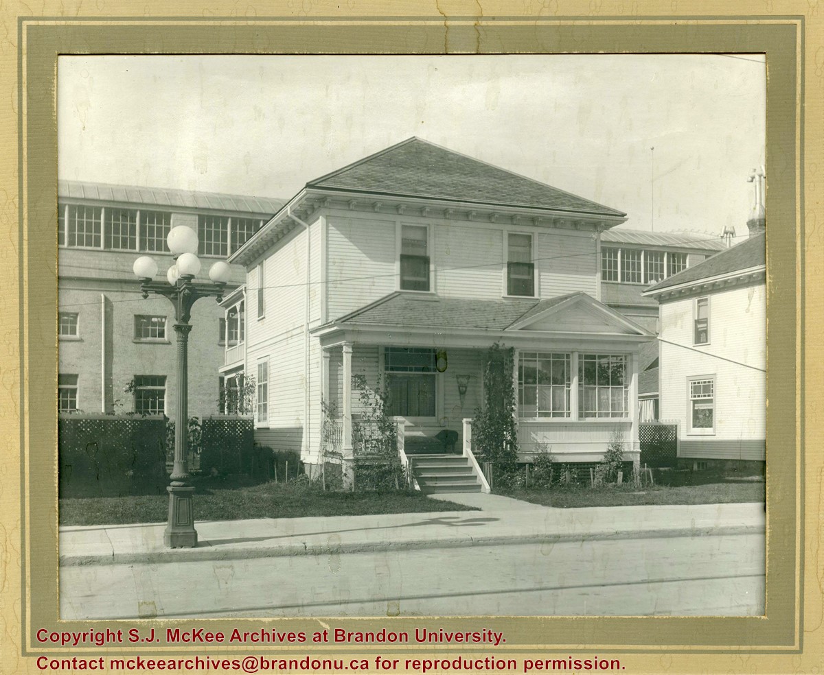
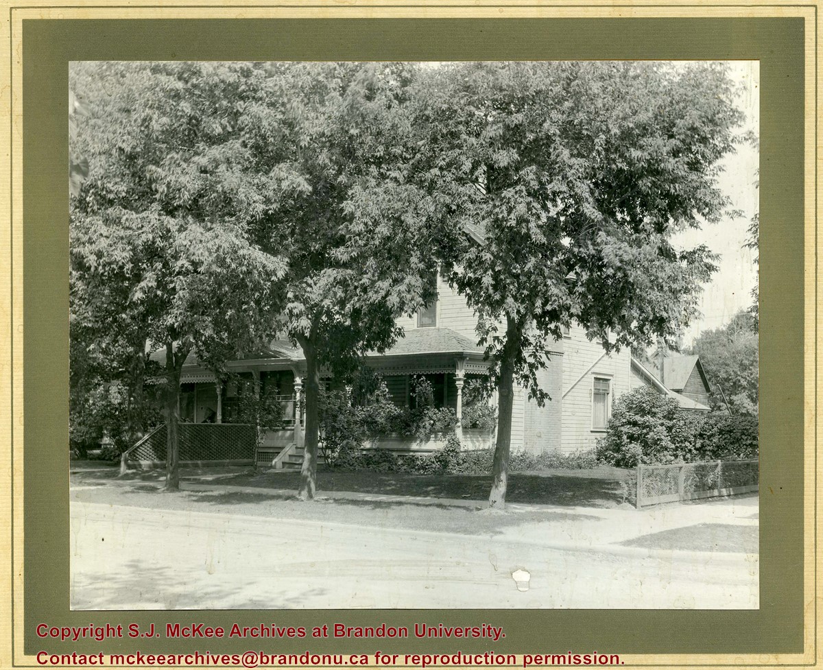
Photograph shows a two-storey wood-framed house with front porch and sunroom. Above a rocking chair and chez lounge, a Union Jack and pennant hang on the exterior wall on the porch. A five-globed black iron street lamp is on the sidewalk in front of the property. The Wheat City Arena can be seen behind the residence.
Notes
Based on the presence of the arena, the location has been identified as 10th Street near Victoria Avenue.
Name Access
Wheat City Arena
Victoria Avenue
10th Street
Subject Access
residences
building exteriors
residential streets
Storage Location
Hughes oversize drawer
Images
Show Less

Medicine Hat Exhibition and Stampede - Parade Day 7

http://archives.brandonu.ca/en/permalink/descriptions14148
Part Of
Fred McGuinness collection
Description Level
Item
GMD
graphic
Date Range
1962
Accession Number
1-2015
Part Of
Fred McGuinness collection
Creator
Photographer: Howard Heid, Medicine Hat News
Description Level
Item
Series Number
McG 9
Item Number
1-2015.217
Accession Number
1-2015
GMD
graphic
Date Range
1962
Physical Description
10" x 8" (b/w)
History / Biographical
The Medicine Hat Exhibition and Stampede Parade Day was held on Thursday, July 19, 1962, at 9:30 a.m. The local newspaper reported that approximately 24,000 people were in attendance to see parade marshall Rod Ashburner leading 175 entries consisting of 90 floats, 75 horses, and 10 bands. There were 19 parade categories eligible for $12,000 in prize money and included: junior and senior cowboys and cowgirls; fancy and Shetland ponies; sulky class open; comic, commercial, industrial and organizational floats; decorated cars; special ranch class; 4-H Clubs; and a non-competitive class. The parade route started at Second St. and Allowance Ave., from Second St. to Ash Ave., north on Ash to First St. SE., from First St. S.E. to Fourth Ave., south to Second St. to South Railway St., south on South Railway St. to Third St., with a finish at McLeod Trail. A route map was published in the Medicine Hat News the day before the parade. Aerial photographs of the parade were taken by Medicine Hat News photographer Howard Heid (1930-2005) from the private helicopter of John Bourn. Bourn was a pilot from Woodville, Wisconsin, who chartered his four-seater helicopter for sight-seers at exhibitions and stampedes across the county. (Sources: Pat Currie, "Let 'Er Go!," Medicine Hat News, 19 July 1962,1; Harald Gunderson, "'Eye in the Sky' Best Parade View," Medicine Hat News, 19 July 1962,1; "Parade Starts at 9:30 Sharp," 18 July 1962)
Scope and Content
Photograph shows an aerial view of the Medicine Hat Exhibition and Stampede Parade route with a focus on the First Street SE and Sixth Avenue intersection. A number of gas stations and garages are visible along this route and include Texaco, Shell, Ford, and B/A. A number of observers can be seen sitting on rooftops.
Notes
This photograph shows the neighbourhood before rezoning and commercial development.
Name Access
Medicine Hat
South Saskatchewan River
Subject Access
parades
floats
aerial photography
aerial views
street scenes
garages
Repro Restriction
Subject to Canadian Copyright Law
Storage Location
RG 5 photograph storage drawer 2 (hanging photos)
Arrangement
BR #3 Family photos
Images
Show Less

Medicine Hat Exhibition and Stampede - Parade Day 8

http://archives.brandonu.ca/en/permalink/descriptions14149
Part Of
Fred McGuinness collection
Description Level
Item
GMD
graphic
Date Range
1962
Accession Number
1-2015
Part Of
Fred McGuinness collection
Creator
Photographer: Howard Heid, Medicine Hat News
Description Level
Item
Series Number
McG 9
Item Number
1-2015.218
Accession Number
1-2015
GMD
graphic
Date Range
1962
Physical Description
10" x 8" (b/w)
History / Biographical
The Medicine Hat Exhibition and Stampede Parade Day was held on Thursday, July 19, 1962, at 9:30 a.m. The local newspaper reported that approximately 24,000 people were in attendance to see parade marshall Rod Ashburner leading 175 entries consisting of 90 floats, 75 horses, and 10 bands. There were 19 parade categories eligible for $12,000 in prize money and included: junior and senior cowboys and cowgirls; fancy and Shetland ponies; sulky class open; comic, commercial, industrial and organizational floats; decorated cars; special ranch class; 4-H Clubs; and a non-competitive class. The parade route started at Second St. and Allowance Ave., from Second St. to Ash Ave., north on Ash to First St. SE., from First St. S.E. to Fourth Ave., south to Second St. to South Railway St., south on South Railway St. to Third St., with a finish at McLeod Trail. A route map was published in the Medicine Hat News the day before the parade. Aerial photographs of the parade were taken by Medicine Hat News photographer Howard Heid (1930-2005) from the private helicopter of John Bourn. Bourn was a pilot from Woodville, Wisconsin, who chartered his four-seater helicopter for sight-seers at exhibitions and stampedes across the county. (Sources: Pat Currie, "Let 'Er Go!," Medicine Hat News, 19 July 1962,1; Harald Gunderson, "'Eye in the Sky' Best Parade View," Medicine Hat News, 19 July 1962,1; "Parade Starts at 9:30 Sharp," 18 July 1962)
Scope and Content
Photograph shows an aerial view of the Medicine Hat Exhibition and Stampede Parade route, with a focus on Second Street SE. Visible store signs include: Gardener's Used Cars, Provincial Treasury Branch, Furvey's Furniture and Appliances, J.J. Moore & Son Furniture, Alberta Credit Jewellers, James Richardson & Sons, Medicine Hat Gas Power Water City Owned Utilities.
Notes
This photograph shows the neighbourhood before rezoning and commercial development.
Name Access
Medicine Hat
South Saskatchewan River
Subject Access
parades
floats
aerial photography
aerial views
street scenes
garages
Repro Restriction
Subject to Canadian Copyright Law
Storage Location
RG 5 photograph storage drawer 2 (hanging photos)
Arrangement
BR #3 Family photos
Images
Show Less

Possible residence on 17th Street

http://archives.brandonu.ca/en/permalink/descriptions14040
Part Of
Fred McGuinness collection
Description Level
Item
GMD
graphic
Date Range
1940
Accession Number
1-2015
Part Of
Fred McGuinness collection
Description Level
Item
Series Number
McG 9
Item Number
1-2015.110
Accession Number
1-2015
GMD
graphic
Date Range
1940
Physical Description
4" x 3.5" (b/w)
Physical Condition
Photograph is ripped
Scope and Content
Photograph shows a two-storey home with wrap around porch and picket fence. Possibly 337-17th Street.
Subject Access
residences
street scenes
building exteriors
Storage Location
RG 5 photograph storage drawer 2 (hanging photos)
Arrangement
BR #3 Family pictures
Images
Show Less

Medicine Hat Exhibition and Stampede - Parade Day 4

http://archives.brandonu.ca/en/permalink/descriptions14145
Part Of
Fred McGuinness collection
Description Level
Item
GMD
graphic
Date Range
1962
Accession Number
1-2015
Part Of
Fred McGuinness collection
Creator
Photographer: Howard Heid, Medicine Hat News
Description Level
Item
Series Number
McG 9
Item Number
1-2015.214
Accession Number
1-2015
GMD
graphic
Date Range
1962
Physical Description
10" x 8" (b/w)
History / Biographical
The Medicine Hat Exhibition and Stampede Parade Day was held on Thursday, July 19, 1962, at 9:30 a.m. The local newspaper reported that approximately 24,000 people were in attendance to see parade marshall Rod Ashburner leading 175 entries consisting of 90 floats, 75 horses, and 10 bands. There were 19 parade categories eligible for $12,000 in prize money and included: junior and senior cowboys and cowgirls; fancy and Shetland ponies; sulky class open; comic, commercial, industrial and organizational floats; decorated cars; special ranch class; 4-H Clubs; and a non-competitive class. The parade route started at Second St. and Allowance Ave., from Second St. to Ash Ave., north on Ash to First St. SE., from First St. S.E. to Fourth Ave., south to Second St. to South Railway St., south on South Railway St. to Third St., with a finish at McLeod Trail. A route map was published in the Medicine Hat News the day before the parade. Aerial photographs of the parade were taken by Medicine Hat News photographer Howard Heid (1930-2005) from the private helicopter of John Bourn. Bourn was a pilot from Woodville, Wisconsin, who chartered his four-seater helicopter for sight-seers at exhibitions and stampedes across the county. (Sources: Pat Currie, "Let 'Er Go!," Medicine Hat News, 19 July 1962,1; Harald Gunderson, "'Eye in the Sky' Best Parade View," Medicine Hat News, 19 July 1962,1; "Parade Starts at 9:30 Sharp," 18 July 1962)
Scope and Content
Photograph shows an aerial view of the Medicine Hat Exhibition and Stampede Parade route with a focus on the First Street SE. A number of gas stations and garages are visible along this route and include Texaco, Shell, Ford, and B/A. The Fraternal Order of Eagles lodge is also visible.
Notes
This photograph appeared on the front page of The Medicine Hat News (19 July 1962).
Name Access
Medicine Hat
South Saskatchewan River
Subject Access
parades
floats
aerial photography
aerial views
street scenes
fraternal organizations
garages
Repro Restriction
Subject to Canadian Copyright Law
Storage Location
RG 5 photograph storage drawer 2 (hanging photos)
Arrangement
BR #3 Family photos
Images
Show Less

Hughes residential property - 7th Street Terrace

http://archives.brandonu.ca/en/permalink/descriptions14272
Part Of
Joseph H. Hughes collection
Description Level
Item
GMD
graphic
Date Range
[1911-1925]
Accession Number
3-1997
Part Of
Joseph H. Hughes collection
Creator
Photographer: C.J. Smith
Description Level
Item
Series Number
3-1997.1
Item Number
3-1997.1.74
Accession Number
3-1997
Other Numbers
Hughes #73
GMD
graphic
Date Range
[1911-1925]
Physical Description
9.5" x 7.5" (b/w)
Material Details
on matting
Physical Condition
Photograph is stained
Scope and Content
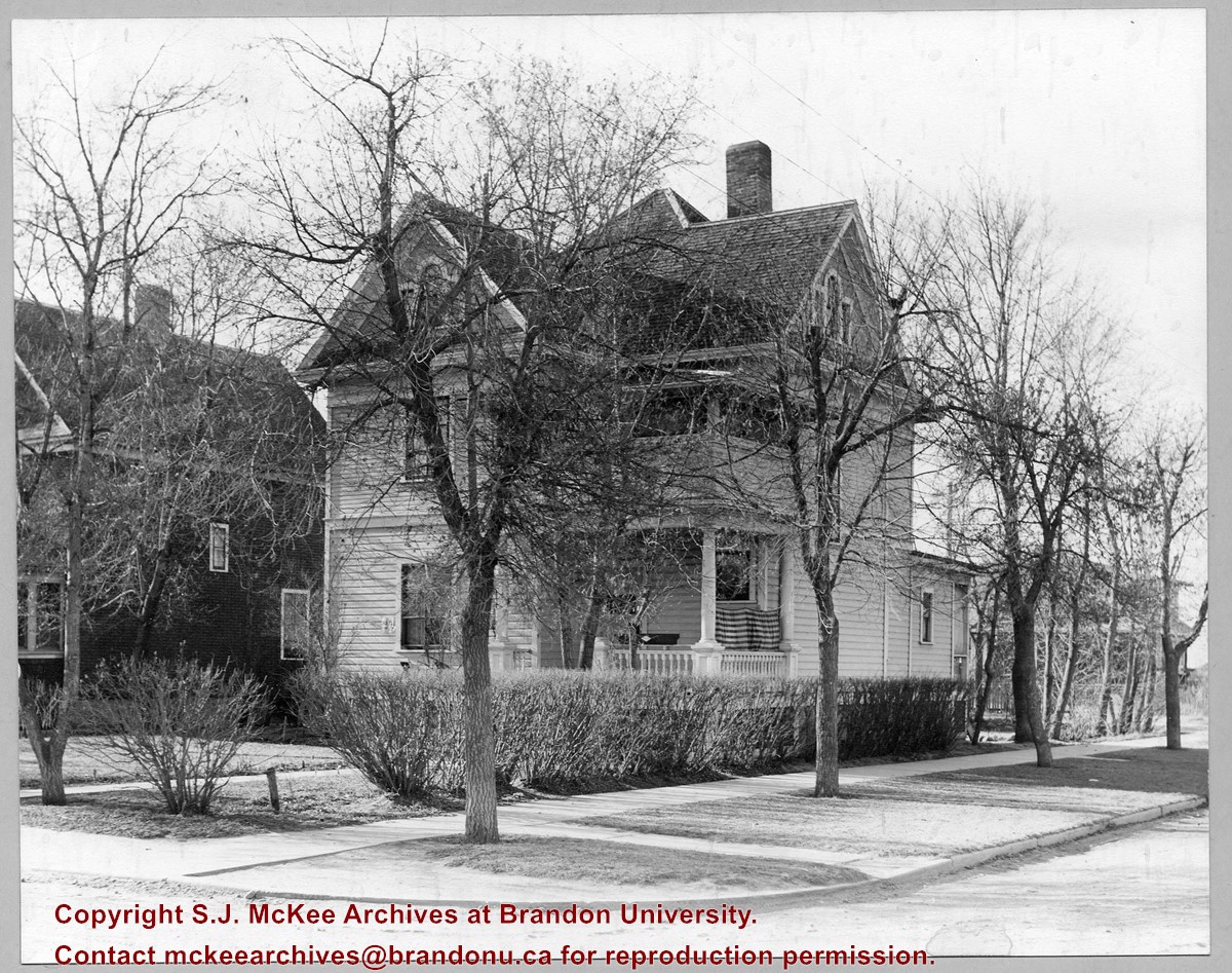
Photograph shows a two-storey wood-framed duplex. The building appears to be situated on a corner. The front verandas have wooden ornamentation and a lattice fence separates the front yards. Flowers and viriginia creeper appear in flower beds along the side of one house.
Notes
The location has been identified as the 7th Street Terrace between Lorne and Louise Avenues.
Subject Access
residences
building exteriors
residential streets
Storage Location
Hughes oversize drawer
Images
Show Less

Medicine Hat Exhibition and Stampede - Parade Day 6

http://archives.brandonu.ca/en/permalink/descriptions14147
Part Of
Fred McGuinness collection
Description Level
Item
GMD
graphic
Date Range
1962
Accession Number
1-2015
Part Of
Fred McGuinness collection
Creator
Photographer: Howard Heid, Medicine Hat News
Description Level
Item
Series Number
McG 9
Item Number
1-2015.216
Accession Number
1-2015
GMD
graphic
Date Range
1962
Physical Description
10" x 8" (b/w)
History / Biographical
The Medicine Hat Exhibition and Stampede Parade Day was held on Thursday, July 19, 1962, at 9:30 a.m. The local newspaper reported that approximately 24,000 people were in attendance to see parade marshall Rod Ashburner leading 175 entries consisting of 90 floats, 75 horses, and 10 bands. There were 19 parade categories eligible for $12,000 in prize money and included: junior and senior cowboys and cowgirls; fancy and Shetland ponies; sulky class open; comic, commercial, industrial and organizational floats; decorated cars; special ranch class; 4-H Clubs; and a non-competitive class. The parade route started at Second St. and Allowance Ave., from Second St. to Ash Ave., north on Ash to First St. SE., from First St. S.E. to Fourth Ave., south to Second St. to South Railway St., south on South Railway St. to Third St., with a finish at McLeod Trail. A route map was published in the Medicine Hat News the day before the parade. Aerial photographs of the parade were taken by Medicine Hat News photographer Howard Heid (1930-2005) from the private helicopter of John Bourn. Bourn was a pilot from Woodville, Wisconsin, who chartered his four-seater helicopter for sight-seers at exhibitions and stampedes across the county. (Sources: Pat Currie, "Let 'Er Go!," Medicine Hat News, 19 July 1962,1; Harald Gunderson, "'Eye in the Sky' Best Parade View," Medicine Hat News, 19 July 1962,1; "Parade Starts at 9:30 Sharp," 18 July 1962)
Scope and Content
Photograph shows an aerial view of the Medicine Hat Exhibition and Stampede Parade route with a focus on the First Street SE and and the South Railway Street merge. A number of gas stations and garages are visible along this route and include Texaco, Shell, Ford, and B/A. The Fraternal Order of Eagles lodge is also visible.
Notes
This photograph shows the neighbourhood before rezoning and commercial development.
Name Access
Medicine Hat
South Saskatchewan River
Subject Access
parades
floats
aerial photography
aerial views
street scenes
gardens
fraternal organizations
garages
Repro Restriction
Subject to Canadian Copyright Law
Storage Location
RG 5 photograph storage drawer 2 (hanging photos)
Arrangement
BR #3 Family photos
Images
Show Less

Hughes residential property, 16th Street and Lorne Ave.

http://archives.brandonu.ca/en/permalink/descriptions14276
Part Of
Joseph H. Hughes collection
Description Level
Item
GMD
graphic
Date Range
[1911-1925]
Accession Number
3-1997
Part Of
Joseph H. Hughes collection
Creator
Photographer: Clark J. Smith
Description Level
Item
Series Number
3-1997.1
Item Number
3-1997.1.78
Accession Number
3-1997
Other Numbers
Hughes #76
GMD
graphic
Date Range
[1911-1925]
Physical Description
9.5" x 7.5" (b/w)
Material Details
on matting
Physical Condition
Photograph and matting are stained
Scope and Content
Photograph shows a three-storey wood-framed home on the southwest corner of 16th Street and Louise Avenue.
Name Access
16th Street
Louise Avenue
Subject Access
residences
residential streets
Storage Location
Hughes oversize drawer
Images
Show Less

McGuinness Medicine Hat residence - 6th Street Northeast

http://archives.brandonu.ca/en/permalink/descriptions14117
Part Of
Fred McGuinness collection
Description Level
Item
GMD
graphic
Date Range
[1960-1965]
Accession Number
1-2015
Part Of
Fred McGuinness collection
Description Level
Item
Series Number
McG 9
Item Number
1-2015.186
Accession Number
1-2015
GMD
graphic
Date Range
[1960-1965]
Physical Description
10" x 8" (b/w)
Scope and Content
Photograph shows the intersection by the McGuinness home (492 6th Street Northeast) in a new housing development in Medicine Hat.
Notes
A negative exists for this photo and is stored with the picture.
Name Access
Fred McGuinness
Frederick George McGuinness
Medicine Hat
Subject Access
residences
street scenes
residential streets
winter
Storage Location
RG 5 photograph storage drawer 2 (hanging photos)
Arrangement
BR #3 Family photos
Images
Show Less

20 records – page 1 of 1.