Photograph shows the west side of the 200-block on 10th Street. Visible businesses include: Chamber of Commerce Tourist Information, Dominion Tire & Radio Co., Bonnie's Bonnet Shop, Steve's Grill, Wally's Taxi, and Western Motors Ltd. The painted advertisement for Doig, Rankin and Robertson is visible on the Alexandra Block. Christmas ornaments are displayed from light standards and include Santa Claus and a Christmas elf.
Red ink stain is on the front right corner of postcard
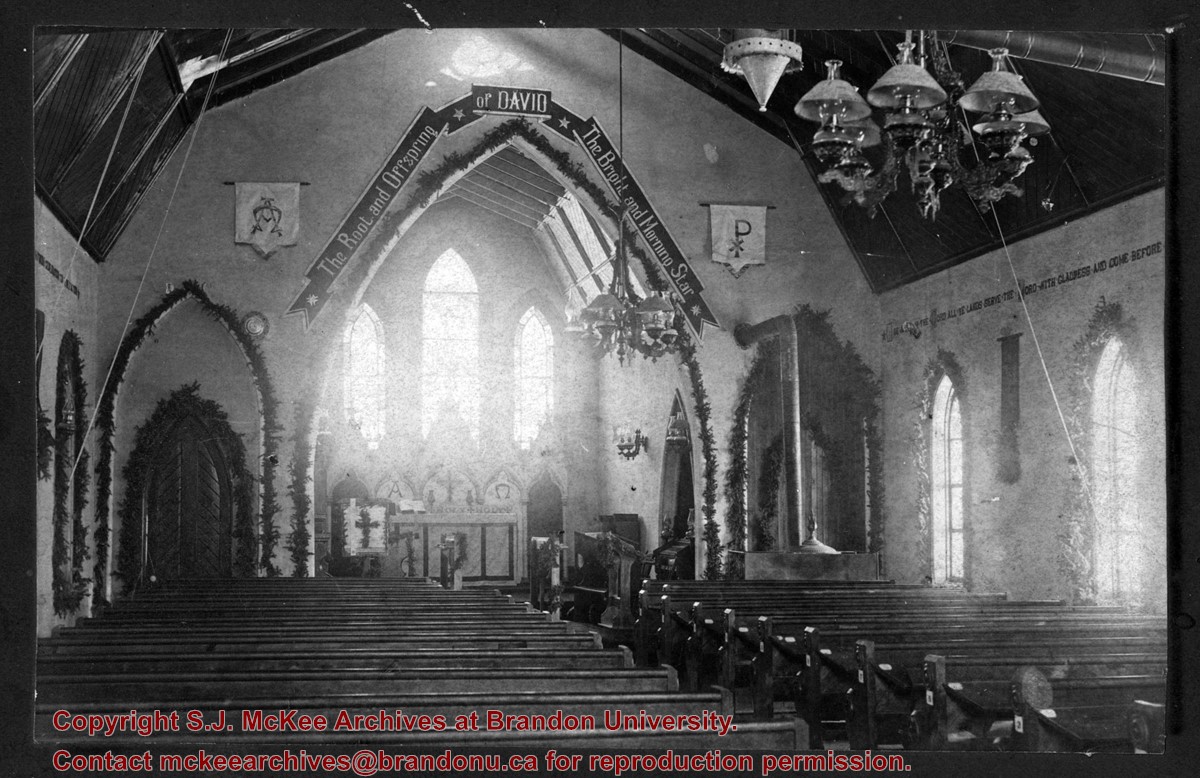
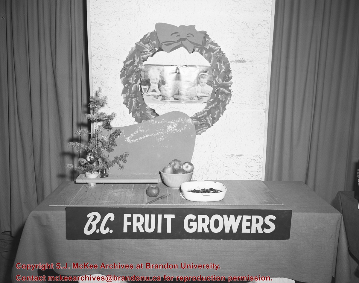
Scope and Content
Photograph shows 10th Street facing south from Princess Avenue. Visible landmarks and businesses include: Manitoba Power Commission (MPC)'s power sub-station, First Baptist Church, Wheat City Arena, and the grand stand at the Exhibition Grounds.
The partial sign visible at the bottom of the photograph on the east side of 10th Street reads Yates and Neale, which refers to a plumbing and heating company that dissolved in 1943 to be replaced by Neale, Stothard and Chapman.
Businesses on the west side of 10th Street include: Dominion Tire & Radio Co., Bolts Barber Shop, Elviss T.E. Co. Stables.
Notes
Information concerning Yates and Neale courtesy Jack Stothard. Writing on the front of the postcard reads: Brandon, Looking S.W., Jerrett Photo. This photograph shows a rare view of the 200-block of 10th Street.
Postcard shows an aerial view of 9th Street facing south in Brandon, Manitoba. Visible businesses and landmarks include: Beaubier Hotel, YMCA/police station, the original CKX Radio station towers on 8th Street (est. 1928 - moved 1940), the old City Hall, Prince Edward Hotel, and the original Manitoba Power commission smokestack on 10th Street.
Notes
Writing on the front of the photograph reads: Brandon, Man., Jerrett Photo. This photograph shows a rare view of the 800-block between Rosser and Princess Avenues.
The Medicine Hat Exhibition and Stampede Parade Day was held on Thursday, July 19, 1962, at 9:30 a.m. The local newspaper reported that approximately 24,000 people were in attendance to see parade marshall Rod Ashburner leading 175 entries consisting of 90 floats, 75 horses, and 10 bands. There were 19 parade categories eligible for $12,000 in prize money and included: junior and senior cowboys and cowgirls; fancy and Shetland ponies; sulky class open; comic, commercial, industrial and organizational floats; decorated cars; special ranch class; 4-H Clubs; and a non-competitive class.
The parade route started at Second St. and Allowance Ave., from Second St. to Ash Ave., north on Ash to First St. SE., from First St. S.E. to Fourth Ave., south to Second St. to South Railway St., south on South Railway St. to Third St., with a finish at McLeod Trail. A route map was published in the Medicine Hat News the day before the parade.
Aerial photographs of the parade were taken by Medicine Hat News photographer Howard Heid (1930-2005) from the private helicopter of John Bourn. Bourn was a pilot from Woodville, Wisconsin, who chartered his four-seater helicopter for sight-seers at exhibitions and stampedes across the county.
(Sources: Pat Currie, "Let 'Er Go!," Medicine Hat News, 19 July 1962,1; Harald Gunderson, "'Eye in the Sky' Best Parade View," Medicine Hat News, 19 July 1962,1; "Parade Starts at 9:30 Sharp," 18 July 1962)
Scope and Content
Photograph shows an aerial view of the Medicine Hat Exhibition and Stampede Parade route with a focus on the First Street SE and Sixth Avenue intersection. A number of gas stations and garages are visible along this route and include Texaco, Shell, Ford, and B/A. A number of observers can be seen sitting on rooftops.
Notes
This photograph shows the neighbourhood before rezoning and commercial development.
The Medicine Hat Exhibition and Stampede Parade Day was held on Thursday, July 19, 1962, at 9:30 a.m. The local newspaper reported that approximately 24,000 people were in attendance to see parade marshall Rod Ashburner leading 175 entries consisting of 90 floats, 75 horses, and 10 bands. There were 19 parade categories eligible for $12,000 in prize money and included: junior and senior cowboys and cowgirls; fancy and Shetland ponies; sulky class open; comic, commercial, industrial and organizational floats; decorated cars; special ranch class; 4-H Clubs; and a non-competitive class.
The parade route started at Second St. and Allowance Ave., from Second St. to Ash Ave., north on Ash to First St. SE., from First St. S.E. to Fourth Ave., south to Second St. to South Railway St., south on South Railway St. to Third St., with a finish at McLeod Trail. A route map was published in the Medicine Hat News the day before the parade.
Aerial photographs of the parade were taken by Medicine Hat News photographer Howard Heid (1930-2005) from the private helicopter of John Bourn. Bourn was a pilot from Woodville, Wisconsin, who chartered his four-seater helicopter for sight-seers at exhibitions and stampedes across the county.
(Sources: Pat Currie, "Let 'Er Go!," Medicine Hat News, 19 July 1962,1; Harald Gunderson, "'Eye in the Sky' Best Parade View," Medicine Hat News, 19 July 1962,1; "Parade Starts at 9:30 Sharp," 18 July 1962)
Scope and Content
Photograph shows an aerial view of the Medicine Hat Exhibition and Stampede Parade route, with a focus on Second Street SE. Visible store signs include: Gardener's Used Cars, Provincial Treasury Branch, Furvey's Furniture and Appliances, J.J. Moore & Son Furniture, Alberta Credit Jewellers, James Richardson & Sons, Medicine Hat Gas Power Water City Owned Utilities.
Notes
This photograph shows the neighbourhood before rezoning and commercial development.
The Medicine Hat Exhibition and Stampede Parade Day was held on Thursday, July 19, 1962, at 9:30 a.m. The local newspaper reported that approximately 24,000 people were in attendance to see parade marshall Rod Ashburner leading 175 entries consisting of 90 floats, 75 horses, and 10 bands. There were 19 parade categories eligible for $12,000 in prize money and included: junior and senior cowboys and cowgirls; fancy and Shetland ponies; sulky class open; comic, commercial, industrial and organizational floats; decorated cars; special ranch class; 4-H Clubs; and a non-competitive class.
The parade route started at Second St. and Allowance Ave., from Second St. to Ash Ave., north on Ash to First St. SE., from First St. S.E. to Fourth Ave., south to Second St. to South Railway St., south on South Railway St. to Third St., with a finish at McLeod Trail. A route map was published in the Medicine Hat News the day before the parade.
Aerial photographs of the parade were taken by Medicine Hat News photographer Howard Heid (1930-2005) from the private helicopter of John Bourn. Bourn was a pilot from Woodville, Wisconsin, who chartered his four-seater helicopter for sight-seers at exhibitions and stampedes across the county.
(Sources: Pat Currie, "Let 'Er Go!," Medicine Hat News, 19 July 1962,1; Harald Gunderson, "'Eye in the Sky' Best Parade View," Medicine Hat News, 19 July 1962,1; "Parade Starts at 9:30 Sharp," 18 July 1962)
Scope and Content
Photograph shows an aerial view of the Medicine Hat Exhibition and Stampede Parade route with a focus on the First Street SE. A number of gas stations and garages are visible along this route and include Texaco, Shell, Ford, and B/A. The Fraternal Order of Eagles lodge is also visible.
Notes
This photograph appeared on the front page of The Medicine Hat News (19 July 1962).
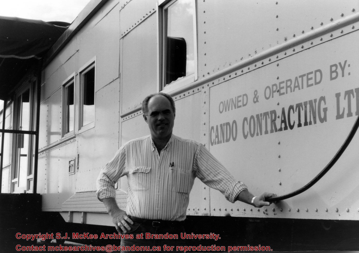
Cando Contracting Ltd. was found in 1978 by Gord Peters and Rick Hammond. The company began as a small rail line dismantling and salvage company operating out of Brandon, Manitoba. The company changed its name in 2013 to Cando Rail Services Ltd., which supplies railway support services (e.g., engineering and track services, industrial rail services, mechanical services, rail car storage, railway material sales, short line operations, transload services) to industry and the rail sector. The company maintains its headquarters in Brandon, Manitoba, and has regional offices located in Calgary, Edmonton, Winnipeg, Whitby, and Adel (Iowa). (Source: www.candoltd.com, accessed 05 Dec 2015)
Scope and Content
Photograph shows Gord Peters standing in front of the rail car that forms the entrance of Cando Contracting Ltd. in Brandon, Manitoba
The Medicine Hat Exhibition and Stampede Parade Day was held on Thursday, July 19, 1962, at 9:30 a.m. The local newspaper reported that approximately 24,000 people were in attendance to see parade marshall Rod Ashburner leading 175 entries consisting of 90 floats, 75 horses, and 10 bands. There were 19 parade categories eligible for $12,000 in prize money and included: junior and senior cowboys and cowgirls; fancy and Shetland ponies; sulky class open; comic, commercial, industrial and organizational floats; decorated cars; special ranch class; 4-H Clubs; and a non-competitive class.
The parade route started at Second St. and Allowance Ave., from Second St. to Ash Ave., north on Ash to First St. SE., from First St. S.E. to Fourth Ave., south to Second St. to South Railway St., south on South Railway St. to Third St., with a finish at McLeod Trail. A route map was published in the Medicine Hat News the day before the parade.
Aerial photographs of the parade were taken by Medicine Hat News photographer Howard Heid (1930-2005) from the private helicopter of John Bourn. Bourn was a pilot from Woodville, Wisconsin, who chartered his four-seater helicopter for sight-seers at exhibitions and stampedes across the county.
(Sources: Pat Currie, "Let 'Er Go!," Medicine Hat News, 19 July 1962,1; Harald Gunderson, "'Eye in the Sky' Best Parade View," Medicine Hat News, 19 July 1962,1; "Parade Starts at 9:30 Sharp," 18 July 1962)
Scope and Content
Photograph shows an aerial view of the Medicine Hat Exhibition and Stampede Parade route with a focus on the First Street SE and and the South Railway Street merge. A number of gas stations and garages are visible along this route and include Texaco, Shell, Ford, and B/A. The Fraternal Order of Eagles lodge is also visible.
Notes
This photograph shows the neighbourhood before rezoning and commercial development.
Postcard shows an exterior view of the Twin Pines Motel
Notes
Writing on the back of the postcard reads: Twin Pines Motel & Restaurant / Brandon, Manitoba, Canada / Located at 10th Street & Queens Avenue / 40 Fully modern units with bath & showers, T. / Kichenettes, winter plug-ins, Ample parking. / For reservations call.... / 30717-C Color Photo by Joe Fartak / Color Productions Ltd., Box 1243, Regina, Sask.
The postcard is addressed to Mr. F.A. Rosser and is postmarked Brandon 06 June 1970. A 6-cent Queen Elizabeth red postage stamp portraying various modes of the transportation.
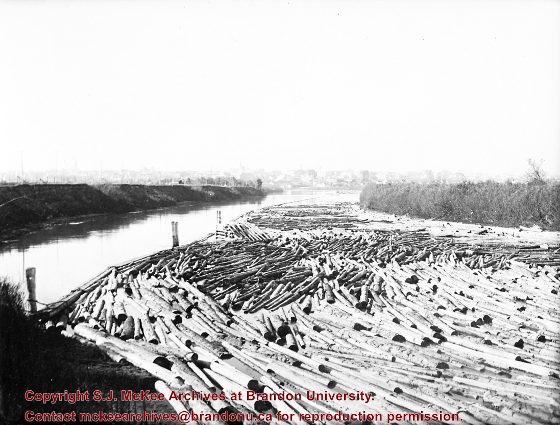
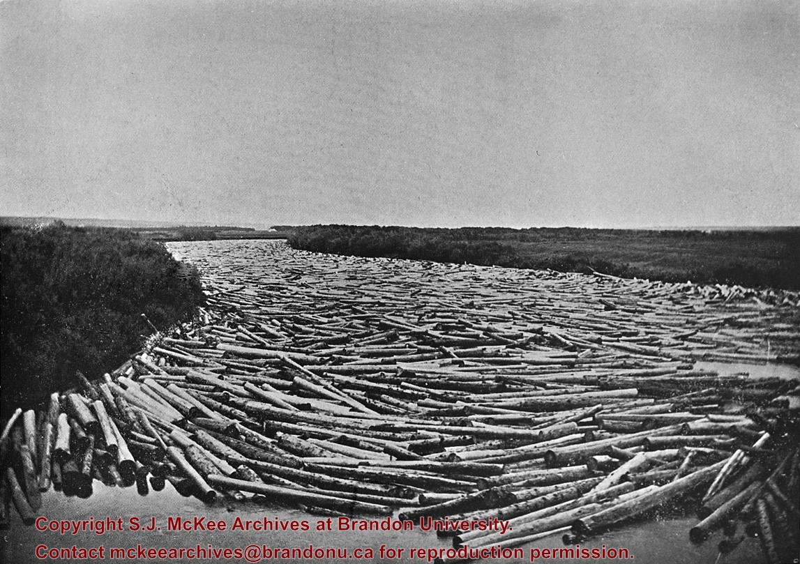
Probably the peak of the sawmilling industry in Brandon was "The Big Drive" in 1910, when 125 drivers brought 5 million board feet of timber down the Assiniboine to Hanbury's Mill
Most of these logs were cut in the Riding Mountains in winter and floated down the Little Saskatchewan and Birdtail Rivers to the Assiniboine.
Custodial History
For custodial history see the collection level description of the Lawrence Stuckey collection.
Scope and Content
Logs, destined for Hanbury Manufacturing Co., in the Assiniboine River
Notes
View from First Street North
Courtesy of the family of E.C. Higgins (Mrs. Millen Dunbar nee May Higgins).
Probably the peak of the sawmilling industry in Brandon was "The Big Drive" in 1910, when 125 drivers brought 5 million board feet of timber down the Assiniboine to Hanbury's Mill.
Most of these logs were cut in the Riding Mountains in winter and floated down the Little Saskatchewan and Birdtail Rivers to the Assiniboine.
Custodial History
For custodial history see the collection level description of the Lawrence Stuckey collection.
Scope and Content
Logs, destined for Hanbury Manufacturing Co., in the Assiniboine River
Notes
Looking north from 3rd Street.
[This negative was produced using a previously published image (P.E.).]
Photograph shows the construction of the McGuinness home in a new housing development in Medicine Hat, 492 6th Street Northeast. Aerial view shows that neighbouring blocks have yet to be constructed.
Photograph shows the McGuinness home in a new housing development in Medicine Hat, 492 6th Street Northeast. Aerial view shows that neighbouring blocks have yet to be constructed and the backyard to the McGuinness home is completed.
These blocks of ice were used to fill the ice houses of the Wheat City Ice Co. (located north of Rosser Avenue on the west side of 15th Street, and south of Princess Avenue on the east side of 17th Street), the CPR icehouses (at the station and 3rd St. & Assiniboine Ave), and the CNR icehouse (at Forth Street and McTavish Avenue). In addition, large quantities of ice were shipped to smaller towns in railcars (usually old refrigerator cars).
Custodial History
For custodial history see the collection level description of the Lawrence Stuckey collection.
Scope and Content
Cutting ice from the Assiniboine River
Notes
This is one of five images that show the method in which ice is cut into blocks and loaded onto sleighs or trucks. Note the large draft horses still in use at this date.
[Mr. Stuckey put five negatives into the same envelope. We have separated them and numbered them H12(1) to H12(5).]
Additional information provided by the Fred McGuinness collection (20-2009).


.jpg?width=1200&404=no-img.jpg&watermark=wmk)
.jpg?width=180&404=no-img.jpg)
.jpg?width=1200&404=no-img.jpg&watermark=wmk)
.jpg?width=180&404=no-img.jpg)
.jpg?width=1200&404=no-img.jpg&watermark=wmk)
.jpg?width=180&404=no-img.jpg)
.jpg%3fmaxheight%3d1000%26maxwidth%3d1000%26watermark%3dwmk&description=Cutting+Ice+from+the+Assiniboine+River)
.jpg%3fmaxheight%3d1000%26maxwidth%3d1000%26watermark%3dwmk&description=Cutting+Ice+from+the+Assiniboine+River)
.jpg%3fmaxheight%3d1000%26maxwidth%3d1000%26watermark%3dwmk&description=Cutting+Ice+from+the+Assiniboine+River)