Image is looking east northeast from approximately the 300 block of 23rd Street between Lorne and Louise Avenues. Photograph shows the Brandon College campus after the opening of the original Music Building in 1963, but before the construction of the Education Building in 1966. A number of house on the 300 blocks of 22nd and 21st Streets are visible in the foreground, with the A.E. McKenzie Seed Co., the Prince Edward Hotel and various grain elevators on the horizon.
View is northeast probably from the roof of McMaster Hall. Photograph shows the construction of the new roof on Clark Hall and the Brandon College Building. A portion of the east side of the 000 and 100 blocks of 18th Street, as well as the corner of 18th Street and Rosser Avenue are visible in the upper left hand corner. This includes the "Downtown Brandon" sign.
View is north northeast probably from the roof of McMaster Hall. Photograph shows the construction of the new roof on Clark Hall and the Brandon College Building, as well as the construction of the extension to Clark Hall and the skywalk. Portions of the city as far north as the Assiniboine River are also visible.
View is north northeast from the roof of McMaster Hall. Photograph shows the campus under construction during the renovation of the Brandon College Building and Clark Hall. The photograph was taken in late fall after the roof had been removed from the buildings but before the construction of the extension of Clark Hall. Construction materials litter the courtyard and driveway. The view looking north extends to The North Hill - a number of residential blocks, particularly to the northeast of 18th Street are visible. Buildings include the International Harvester Building and Kin Village.
View is north northeast probably from the roof of McMaster Hall. Photograph shows the construction of the new roof on Clark Hall and the Brandon College Building, as well as the construction of the extension to Clark Hall and the skywalk. The view looking north extends to The North Hill - a number of residential blocks, particularly to the northeast of 18th Street are visible. Buildings include the International Harvester Building and Kin Village.
Brandon College looking south from 19th Street. Photograph was taken after Flora Cowan Hall was built but before construction of the Education Building.
View is southwest from approximatley 16th Street between Princess and Rosser Avenues. Photograph shows the Brandon University campus, as well as surrounding residential blocks, including Flemming, J.R. Reid and Vincent Massey schools.
View is west southwest from approximatley 16th Street between Princess and Lorne Avenues. Photograph shows the Brandon University campus, as well as surrounding residential blocks between 16th and 23rd Streets, Princess and Louise Avenues..
View is west from approximatley 17th Street between Lorne and Louise Avenues. Photograph shows a portion of the Brandon University campus (excluding the Education Building and anything north of it), as well as surrounding residential blocks from approximatley 17th Street to 22nd Street.
View is west northwest from approximatley 16th Street and Louise Avenue. Photograph shows the Brandon University campus, prior to the Library Extension, and a large portion of the city to the west of the campus.
View is northwest from approximatley 16th Street and Louise Avenue. Photograph shows the Brandon University campus, prior to the Library Extension, and a large portion of the city to the west of the campus.
Image shows the Brandon College campus from 17th Street looking southwest. The photo was taken after the completion of the original Music Building in 1963, but construction of the Education Building. Also visible are a number of properties on the 200 block of 18th Street and the 200 block of 20th Street.
View is northwest from Clark Hall. Photograph shows construction materials in the area between Clark Hall and the A.E. McKenzie Building during winter. The Western Manitoba Centennial Auditorium is visible in the upper right hand corner.
View is south southeast from the skywalk. Photograph shows the courtyard in winter full of vehicles, machines and building materials. Also visible are the Development and Physical Plant H-Huts, the Citizens' Science Building, the John R. Brodie Science Centre and McMaster Hall.
View is northwest from the roof of the Brandon College Building. Photograph was taken through wire fencing and shows construction on the roof of the Brandon College Building during winter. The original Clark Hall entrance to the roof is clearly visible. Portions of the A.E. McKenzie Building, Clark Hall and the Western Manitoba Centennial Auditorium are visible in the background.
Photograph was taken from the skywalk and shows students leaving the George T. Richardson Centre during winter. The courtyard contains construction materials. The Physical Plant H-Hut and McMaster Hall are partially visible in the background.
Laurie V. Smith served as the President of the Brandon Branch of the Royal Canadian Legion during the 1940s.
Custodial History
This fonds was accessioned by the McKee Archives in 1997. Prior custodial history is unknown.
Scope and Content
Fonds includes correspondence, policy documents, and publications relating to the activities of the Royal Canadian Legion, primarily in Brandon under the Presidency of Laurie V. Smith, during and after the Second World War. Prominant themes include the aquiring of gifts for hospitalized veterans, primarily through the Canadian Legion Christmas Tree project, veteran rehabilitation, and promotion of the Canadian Victory Loans project.
View is northeast from the Brandon College Building. Photograph shows the inside of the Brandon College Building after it had been gutted and then partially rebuilt. The exterior fascade of the west side of the building can be clearly seen in this photograph. A number of houses on the east side of 200 block of 18th Street are also visible, as is the stone fence on Princess Avenue and the flag pole on the front lawn.
The Canadian Union of Public Employees came into existence in September 1963, during a convention in Winnipeg when The National Union of Public Employees and the National Union of Public Service Employees merged. In 1964, the Manitoba Division of CUPE (now CUPE Manitoba) held its founding convention in The Pas. At that time, there were 12 affiliated local unions and a total membership of 1,300. The Canadian Union of Public Employees is Canada's largest union. Public service employees formed CUPE to protect their rights, to negotiate wages and working conditions, and to achieve dignity in the workplace.
Custodial History
Fonds was in the possesssion of the Brandon CUPE Office until its donation to the S.J. McKee Archives in 1995.
Scope and Content
Fonds contains general administrative files of the CUPE including agreements, newspaper clippings, correspondence, and convention records. In addition, fonds includes records for many CUPE locals in southwestern and north-central Manitoba. These includes files for each local containing agreements, lists of officials, correspondence and financial records. An extensive body of records dating from 1956 exists for CUPE local #69. This local began its existence as the Brandon Civic Employees Federal Union formed in April 1919.
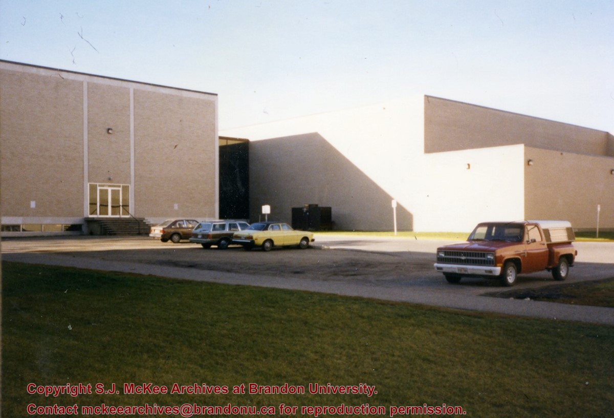
Photograph is looking southwest from in front of the Original Music Building and shows the north side of the A.E. McKenzie Building and the west side of the Queen Elizabeth II Music Building (including the link). A number of cars in the parking lot are also visible.


