Skip header and navigation

Revise Search

20 records – page 1 of 1.

Brandon College campus from the north

http://archives.brandonu.ca/en/permalink/descriptions957
Part Of
Aerial views and campus photographs
Description Level
Item
GMD
graphic
Date Range
c. 1950s
Part Of
Aerial views and campus photographs
Description Level
Item
Series Number
2.1
Item Number
2.1.39
GMD
graphic
Date Range
c. 1950s
Physical Description
4.5" x 2.75" (b/w)
Scope and Content
View is southwest. Photograph shows: Clark Hall, the Brandon College Building and the Citizens' Science Building.
Images
Show Less

Aerial view: Brandon College campus from north

http://archives.brandonu.ca/en/permalink/descriptions615
Part Of
Aerial views and campus photographs
Description Level
Item
GMD
graphic
Date Range
c. 1963
Part Of
Aerial views and campus photographs
Description Level
Item
Series Number
2.1
Item Number
2.1.23
GMD
graphic
Date Range
c. 1963
Physical Description
5" x 4" (b/w)
Scope and Content
View is north, taken from approximatley 19th Street and Rosser Avenue. Photograph shows: Clark Hall, the A.E. McKenzie Building, the J.R.C. Evans Lecture Theatre, H-Huts, Darrach Hall and Flora Cowan Hall, as well as a number of homes in the area.
Images
Show Less

Aerial view: Brandon College looking west

http://archives.brandonu.ca/en/permalink/descriptions595
Part Of
Aerial views and campus photographs
Description Level
Item
GMD
graphic
Date Range
c. spring 1963
Part Of
Aerial views and campus photographs
Description Level
Item
Series Number
2.1
Item Number
2.1.3
GMD
graphic
Date Range
c. spring 1963
Physical Description
10" x 8" (b/w)
Scope and Content
View is west to McDiarmid Drive from approximately 16th Street between Princess and Louise Avenues. Photograph shows: Brandon College, Fleming School, Coronation Park, and West End Community Centre.
Images
Show Less

Brandon College north driveway entrance

http://archives.brandonu.ca/en/permalink/descriptions8070
Part Of
Aerial views and campus photographs
Description Level
Item
GMD
graphic
Date Range
c. 1964
Part Of
Aerial views and campus photographs
Description Level
Item
Series Number
2.1
Item Number
2.1.139
GMD
graphic
Date Range
c. 1964
Physical Description
10" x 8" (b/w)
Scope and Content
View is southwest from the north side of Princess Avenue. Photograph shows the north driveway entrance on campus. The original Music Building, the A.E. McKenzie Building, Clark Hall and part of the Brandon College Building are visible.
Images
Show Less

Brandon from the Assiniboine bridge

http://archives.brandonu.ca/en/permalink/descriptions8958
Part Of
RG 1 Brandon College fonds
Description Level
Item
GMD
graphic
Date Range
c. 1939
Accession Number
8-2009
Part Of
RG 1 Brandon College fonds
Description Level
Item
Series Number
MG 1 1.11
Item Number
8-2009.6
Accession Number
8-2009
GMD
graphic
Date Range
c. 1939
Physical Description
4.25" x 2.5" (b/w)
Custodial History
See MG 1 Brandon College Teaching and Administration, 1.11 Martin Johns fonds for custodial history.
Scope and Content
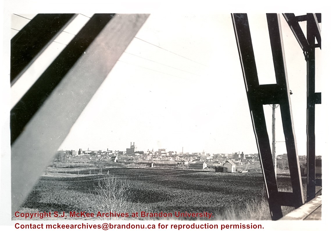
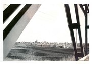
Photograph is looking south southeast from the Assiniboine bridge on 18th Street and shows the Brandon cityscape in the background.
Notes
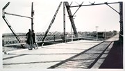
Writing on the back of the photo reads: "Brandon from the Assiniboine bridge. The 2 girls were just local coloring. Don't ask me who they were or are? The College is just off the street on the right away in the background."
Storage Location
Photographs: RG 5 photograph storage drawer
Images
Show Less

Brandon from the Assiniboine bridge

http://archives.brandonu.ca/en/permalink/descriptions8959
Part Of
RG 1 Brandon College fonds
Description Level
Item
GMD
graphic
Date Range
1939
Accession Number
8-2009
Part Of
RG 1 Brandon College fonds
Description Level
Item
Series Number
MG 1 1.11
Item Number
8-2009.7
Accession Number
8-2009
GMD
graphic
Date Range
1939
Physical Description
3.5" x 2.5" (b/w)
Custodial History
See MG 1 Brandon College Teaching and Administration, 1.11 Martin Johns fonds for custodial history.
Scope and Content
Photograph is looking southeast from the Assiniboine bridge on 18th Street and shows the Brandon cityscape.
Notes
Writing on the back of the photo reads: "Brandon from bridge over Assiniboine."
Storage Location
Photographs: RG 5 photograph storage drawer
Images
Show Less

Aerial view: Brandon College campus

http://archives.brandonu.ca/en/permalink/descriptions8272
Part Of
Aerial views and campus photographs
Description Level
Item
GMD
graphic
Date Range
c. 1964
Part Of
Aerial views and campus photographs
Description Level
Item
Series Number
2.1
Item Number
2.1.1
GMD
graphic
Date Range
c. 1964
Physical Description
4" x 5" (b/w)
Scope and Content
Photograph is looking northwest from approximately the southeast corner of 18th Street and Louise Avenue.
Name Access
Flora Cowan Residence
Subject Access
Aerial views Brandon College
Images
Show Less

Bertha Leith (nee Clark) fonds

http://archives.brandonu.ca/en/permalink/descriptions3613
Part Of
RG 1 Brandon College fonds
Description Level
Sub-series
GMD
graphic
Date Range
1925-1929
Accession Number
7-2009
Part Of
RG 1 Brandon College fonds
Creator
Bertha Clark
Description Level
Sub-series
Series Number
MG 2 2.31
Accession Number
7-2009
GMD
graphic
Date Range
1925-1929
Physical Description
24 photographs (b/w)
History / Biographical
Bertha Miriam Clark was born on Prince Edward Island but attended public and high school in Brandon, MB. She was a member of the Class of 1929 and served as Lady Stick in her final year at Brandon College. Clark married J. Scott Leith, Brandon College Class of 1928. Scott and Bertha Leith's son James Clark Leith is in the Canadian Who's Who.
Custodial History
Album was sent to Pat Britton, Brandon University Director of Alumni Relations, by Bertha Leith in April 1991. Britton then transferred it to the McKee Archives.
Scope and Content
Fonds consists of a small accordian style photograph album (7 x 10.5 x 3.5 cm) created by Bertha Clark during her years at Brandon College. The photographs, which measure 4" x 2.75", depict numerous people and events.
Notes
History/Bio information taken from the 1928-1929 Sickle.
Name Access
Bertha Clark
Ruth Bingham
Professor Richards
Lil Bullman
Clark Hall
Brandon College Building
Jean Hitchings
Lloyd Bowler
Kay Underwood
Scott Leith
Denis Phillpots
Donald Ritchie
Harold Cairns
Andrew Clark
Isabel Hitchings
A. Foster
Rundle McLachlan
Carl Wickland
Doris Bingham
Doris Dowling
Ella Whitmore
Meta Mischpeter
Vera Ulinder
Josh Thompson
Doris Cochrane
Frank Kerr
Cyril Richards
Thomas Russell Wilkins
Flo Turnbull
Esther Magoon
Hilda Harrison
Doris Ireton
Mrs. Richards
W.L. Wright
Annie Evans Wright
Miss Hatch
Jennie Turnbull
Mrs. MacNeill
Mrs. C.G. Stone
Helen Duncan
Constance Lamontagne
Marian Bulloch
Mabel Craig
Subject Access
Class of 29'
Sports Day 1925
English Club
Graduation
Lake Percy
Arts 1929
CPR depot
Brandon College boys 1925-1927
al(l)-bums
"cat-chers"
Sykes
18th Street Hill
Class of 1928
Class of 1929
Class of 1930
Class of 1931
arts faculty outing
Storage Location
MG 2 Brandon College Students 2.31 Bertha Leith (nee Clark)
Related Material
Edward Lloyd Bowler collection (36-1999)
Show Less

Brandon College campus

http://archives.brandonu.ca/en/permalink/descriptions727
Part Of
Aerial views and campus photographs
Description Level
Item
GMD
graphic
Date Range
c. 1961
Part Of
Aerial views and campus photographs
Description Level
Item
Series Number
2.1
Item Number
2.1.145
GMD
graphic
Date Range
c. 1961
Physical Description
3.5" x 5" (colour)
Material Details
Kodak paper
Scope and Content
Photograph is looking northwest probably from the northwest corner of 18th Street and Louise Avenue. The photographer was laying down when s/he took the shot. Photograph shows the field to the south of the Citizens' Science Building, as well as the Citizens' Science Building, part of the Brandon College Building and Clark Hall, and two H-Huts. The photo was taken in summer as the field is full of dandelions.
Images
Show Less

Brandon University campus

http://archives.brandonu.ca/en/permalink/descriptions771
Part Of
Aerial views and campus photographs
Description Level
Item
GMD
graphic
Date Range
c. 1980
Part Of
Aerial views and campus photographs
Description Level
Item
Series Number
2.1
Item Number
2.1.31
GMD
graphic
Date Range
c. 1980
Physical Description
5" x 4" (b/w)
Scope and Content
View is southwest from approximately 18th Street and Lorne Avenue. Photograph shows the Brandon University campus in winter, including: the Brandon University sign, the John R. Brodie Science Centre, the Citizens' Science Building and McMaster Hall.
Images
Show Less

Brandon University campus

http://archives.brandonu.ca/en/permalink/descriptions779
Part Of
Aerial views and campus photographs
Description Level
Item
GMD
graphic
Date Range
c. late 1970s
Part Of
Aerial views and campus photographs
Description Level
Item
Series Number
2.1
Item Number
2.1.46
GMD
graphic
Date Range
c. late 1970s
Physical Description
7" x 5" (colour)
Scope and Content
View is southwest from the north side of Princess Avenue. Photograph shows the original Music Building, the north driveway entrance and parts of Clark Hall and the Brandon College building.
Images
Show Less

Brandon University campus

http://archives.brandonu.ca/en/permalink/descriptions788
Part Of
Aerial views and campus photographs
Description Level
Item
GMD
graphic
Date Range
c. 1975
Part Of
Aerial views and campus photographs
Description Level
Item
Series Number
2.1
Item Number
2.1.47
GMD
graphic
Date Range
c. 1975
Physical Description
5" x 5" (b/w)
Scope and Content
View is southwest from the sidewalk on the west side of 18th Street. Photograph shows the Brandon University sign, the front lawn, the Citizens' Science Building, McMaster Hall and the John R. Brodie Science Centre.
Images
Show Less

Brandon University campus

http://archives.brandonu.ca/en/permalink/descriptions804
Part Of
Aerial views and campus photographs
Description Level
Item
GMD
graphic
Date Range
1966
Part Of
Aerial views and campus photographs
Description Level
Item
Series Number
2.1
Item Number
2.1.48
GMD
graphic
Date Range
1966
Physical Description
10" x 8" (b/w)
Scope and Content
View is south from the north side of Princess Avenue. Photograph shows the walkway leading south across campus, the original Music Building, the A.E. McKenzie Building, the J.R.C. Evans Lecture Theatre, Flora Cowan Hall and Darrach Hall.
Images
Show Less

Brandon University campus

http://archives.brandonu.ca/en/permalink/descriptions805
Part Of
Aerial views and campus photographs
Description Level
Item
GMD
graphic
Date Range
1966
Part Of
Aerial views and campus photographs
Description Level
Item
Series Number
2.1
Item Number
2.1.49
GMD
graphic
Date Range
1966
Physical Description
10" x 8" (b/w)
Scope and Content
View is southwest from Princess Avenue. Photograph shows the original Music Building, the A.E. McKenzie Building, the J.R.C. Evans Lecture Theatre and Darrach Hall. Also visible are the field where the Western Manitoba Centennial Auditorium now stands, as well as a number of houses on 20th Street.
Images
Show Less

Brandon College campus

http://archives.brandonu.ca/en/permalink/descriptions819
Part Of
Aerial views and campus photographs
Description Level
Item
GMD
graphic
Date Range
c. 1960s
Part Of
Aerial views and campus photographs
Description Level
Item
Series Number
2.1
Item Number
2.1.51
GMD
graphic
Date Range
c. 1960s
Physical Description
10" x 8" (b/w)
Scope and Content
View is southwest. Photograph shows Clark Hall, the Brandon College Building, the Citizens' Science Building and the driveway running in front of the buildings. Portions of the front lawn and the Kinsmen Staduim are also visible.
Images
Show Less

Brandon University campus

http://archives.brandonu.ca/en/permalink/descriptions836
Part Of
Aerial views and campus photographs
Description Level
Item
GMD
graphic
Date Range
1977
Part Of
Aerial views and campus photographs
Description Level
Item
Series Number
2.1
Item Number
2.1.52
GMD
graphic
Date Range
1977
Physical Description
10" x 8" (b/w)
Scope and Content
View is northeast fron the west side of the Dining Hall. Photograph shows portions of the J.R.C. Evans Lecture Theatre and the A.E. McKenzie Building, as well as an H-Hut, Clark Hall, the Brandon College Building and the quadrangle.
Images
Show Less

Brandon University driveway

http://archives.brandonu.ca/en/permalink/descriptions841
Part Of
Aerial views and campus photographs
Description Level
Item
GMD
graphic
Date Range
c. 1980s
Part Of
Aerial views and campus photographs
Description Level
Item
Series Number
2.1
Item Number
2.1.35
GMD
graphic
Date Range
c. 1980s
Physical Description
3.5" x 5" (b/w)
Scope and Content
View is north from approximately the Citizens' Science Building. Photograph shows the driveway running in front of the Brandon College Building and Clark Hall, a number of cars and students along the driveway and the Education Building in the background.
Images
Show Less

Brandon University campus

http://archives.brandonu.ca/en/permalink/descriptions850
Part Of
Aerial views and campus photographs
Description Level
Item
GMD
graphic
Date Range
May 1978
Part Of
Aerial views and campus photographs
Description Level
Item
Series Number
2.1
Item Number
2.1.36
GMD
graphic
Date Range
May 1978
Physical Description
5" x 3.5" (colour)
Scope and Content
View is northwest from the front lawn. Clark Hall and the Education Building are visible between the trees.
Images
Show Less

Brandon University campus

http://archives.brandonu.ca/en/permalink/descriptions866
Part Of
Aerial views and campus photographs
Description Level
Item
GMD
graphic
Date Range
October 1981
Part Of
Aerial views and campus photographs
Description Level
Item
Series Number
2.1
Item Number
2.1.37
GMD
graphic
Date Range
October 1981
Physical Description
3.5" x 5" (colour)
Scope and Content
View is south from the lawn in front of the Education Building and shows a student exiting the building. The driveway and John R. Brodie Science Centre are visible in the background.
Images
Show Less

Brandon College campus

http://archives.brandonu.ca/en/permalink/descriptions916
Part Of
Aerial views and campus photographs
Description Level
Item
GMD
graphic
Date Range
c. 1966
Part Of
Aerial views and campus photographs
Creator
Miles Photos
Description Level
Item
Series Number
2.1
Item Number
2.1.53
GMD
graphic
Date Range
c. 1966
Physical Description
10" x 8" (b/w)
Scope and Content
View is northwest from the front lawn. Photograph shows the Citizens' Science Building, an H-Hut, the Brandon College Building, Clark Hall and the original Music Building.
Images
Show Less

20 records – page 1 of 1.