Skip header and navigation

Revise Search

20 records – page 1 of 1.

Part Of
Brandon University Photograph collection
Description Level
Item
GMD
graphic
Date Range
c. 1985
Part Of
Brandon University Photograph collection
Description Level
Item
Series Number
2.1
Item Number
BUPC 2.1.60
GMD
graphic
Date Range
c. 1985
Physical Description
5" x 3.5" (colour)
Scope and Content
Photograph shows the removal of one of the houses formerly located on 20th Street between Louise and Princess Avenues. The houses on those blocks were removed to create parking lots for the University. A Fed Zavislak Ltd. Well Drilling & Trucking pickup truck is visible at the curb.
Subject Access
campus photographs
Brandon streets
Images
Show Less
Part Of
Brandon University Photograph collection
Description Level
Item
GMD
graphic
Date Range
c. 1985
Part Of
Brandon University Photograph collection
Description Level
Item
Series Number
2.1
Item Number
BUPC 2.1.61
GMD
graphic
Date Range
c. 1985
Physical Description
5" x 3.5" (colour)
Scope and Content
Photograph shows the removal of one of the houses formerly located on 20th Street between Louise and Princess Avenues. The houses on those blocks were removed to create parking lots for the University.
Subject Access
campus photographs
Brandon streets
Images
Show Less

Brandon University campus construction

http://archives.brandonu.ca/en/permalink/descriptions8016
Part Of
Brandon University Photograph collection
Description Level
Item
GMD
graphic
Date Range
c. 1996
Part Of
Brandon University Photograph collection
Creator
Photographer: Sandy Black
Description Level
Item
Series Number
2.1
Item Number
BUPC 2.1.82
GMD
graphic
Date Range
c. 1996
Physical Description
4" x 6" (colour)
Scope and Content
View is northeast from the Brandon College Building. Photograph shows the inside of the Brandon College Building after it had been gutted and then partially rebuilt. The exterior fascade of the west side of the building can be clearly seen in this photograph. A number of houses on the east side of 200 block of 18th Street are also visible, as is the stone fence on Princess Avenue and the flag pole on the front lawn.
Subject Access
campus photographs
campus construction
Brandon streets
Images
Show Less

Hesson home and family

http://archives.brandonu.ca/en/permalink/descriptions10192
Part Of
RG 12 Brandon and Area Photograph Collection
Description Level
Item
GMD
graphic
Date Range
[188-?]
Accession Number
4-1999
Part Of
RG 12 Brandon and Area Photograph Collection
Description Level
Item
Series Number
5
Item Number
BAPC 5.2
Accession Number
4-1999
GMD
graphic
Date Range
[188-?]
Physical Description
5.25" x 7.75" (b/w)
Material Details
On matting
History / Biographical
From the back of the photograph: Members of the Wolsley expedition were quartered in the house in 1885 (Northwest Rebellion) and the Hessons moved into the house behind (roof just showing). It had 1882 carved under the front gable.
Custodial History
Donated to the Brandon College Library by Hilda Hesson in 1967.
Scope and Content
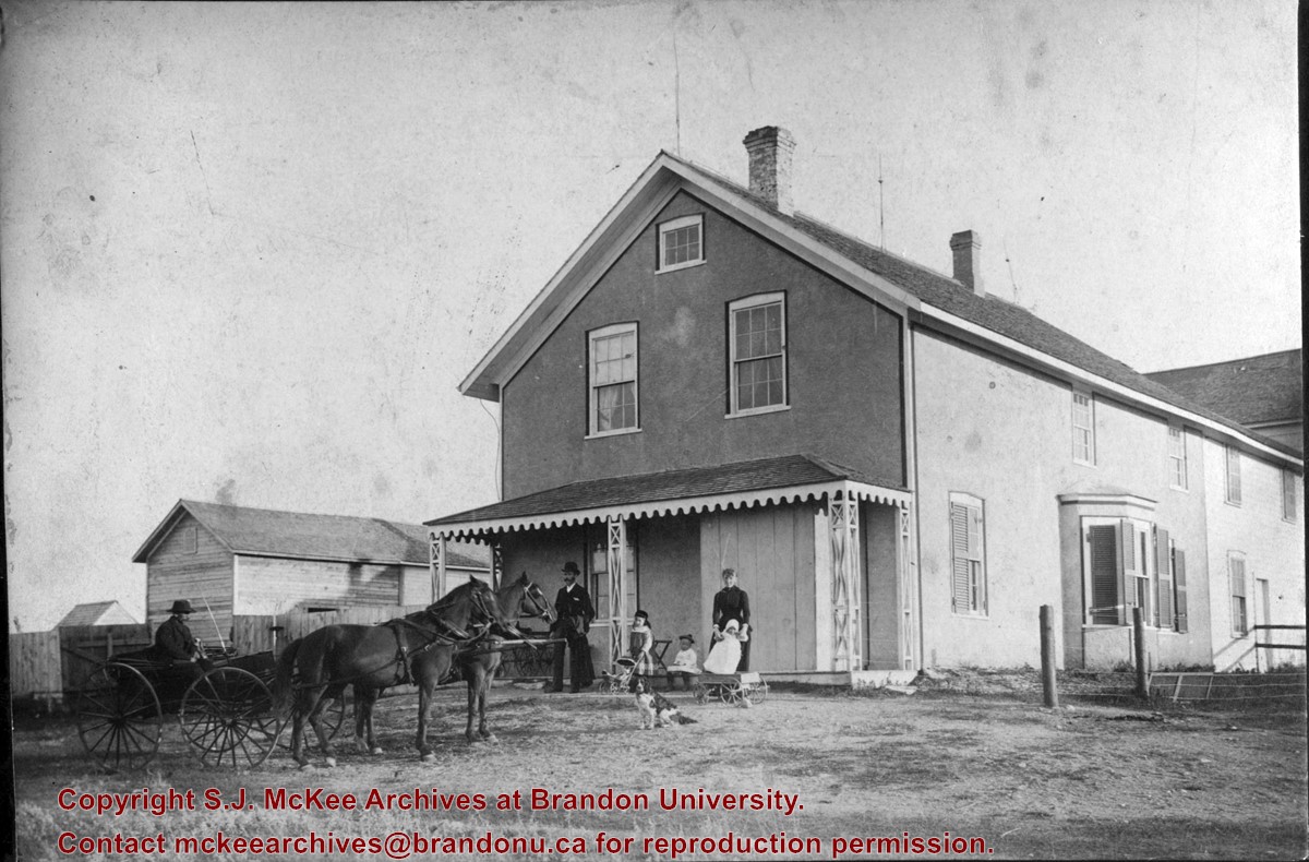
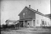
Photograph of the Hesson home and family in the 1880’s. The house was located on First Street just north of Rosser on the east side. The man in the buggy was known as Joe.
Name Access
Hesson
Subject Access
private residences
Storage Location
BAPC photograph drawer
Images
Show Less

Brandon University campus construction

http://archives.brandonu.ca/en/permalink/descriptions8005
Part Of
Brandon University Photograph collection
Description Level
Item
GMD
graphic
Date Range
c. 1996
Part Of
Brandon University Photograph collection
Creator
Photographer: Sandy Black
Description Level
Item
Series Number
2.1
Item Number
BUPC 2.1.71
GMD
graphic
Date Range
c. 1996
Physical Description
4" x 6" (colour)
Scope and Content
View is northeast probably from the roof of McMaster Hall. Photograph shows the construction of the new roof on Clark Hall and the Brandon College Building. A portion of the east side of the 000 and 100 blocks of 18th Street, as well as the corner of 18th Street and Rosser Avenue are visible in the upper left hand corner. This includes the "Downtown Brandon" sign.
Subject Access
campus photographs
campus buildings
campus construction
Brandon streets
Images
Show Less

Brandon University campus construction

http://archives.brandonu.ca/en/permalink/descriptions8006
Part Of
Brandon University Photograph collection
Description Level
Item
GMD
graphic
Date Range
c. 1996
Part Of
Brandon University Photograph collection
Creator
Photographer: Sandy Black
Description Level
Item
Series Number
2.1
Item Number
BUPC 2.1.72
GMD
graphic
Date Range
c. 1996
Physical Description
6" x 4" (colour)
Scope and Content
View is north northeast probably from the roof of McMaster Hall. Photograph shows the construction of the new roof on Clark Hall and the Brandon College Building, as well as the construction of the extension to Clark Hall and the skywalk. Portions of the city as far north as the Assiniboine River are also visible.
Subject Access
campus photographs
campus buildings
campus construction
Brandon streets
Images
Show Less

Brandon University campus construction

http://archives.brandonu.ca/en/permalink/descriptions8018
Part Of
Brandon University Photograph collection
Description Level
Item
GMD
graphic
Date Range
c. 1996
Part Of
Brandon University Photograph collection
Description Level
Item
Series Number
2.1
Item Number
BUPC 2.1.84
GMD
graphic
Date Range
c. 1996
Physical Description
6" x 4" (colour)
Scope and Content
View is north northeast from the roof of McMaster Hall. Photograph shows the campus under construction during the renovation of the Brandon College Building and Clark Hall. The photograph was taken in late fall after the roof had been removed from the buildings but before the construction of the extension of Clark Hall. Construction materials litter the courtyard and driveway. The view looking north extends to The North Hill - a number of residential blocks, particularly to the northeast of 18th Street are visible. Buildings include the International Harvester Building and Kin Village.
Subject Access
campus photographs
campus buildings
campus construction
Brandon streets
Images
Show Less

Brandon University campus construction

http://archives.brandonu.ca/en/permalink/descriptions8020
Part Of
Brandon University Photograph collection
Description Level
Item
GMD
graphic
Date Range
c. 1996
Part Of
Brandon University Photograph collection
Creator
Photographer: Sandy Black
Description Level
Item
Series Number
2.1
Item Number
BUPC 2.1.86
GMD
graphic
Date Range
c. 1996
Physical Description
6" x 4" (colour)
Scope and Content
View is north northeast probably from the roof of McMaster Hall. Photograph shows the construction of the new roof on Clark Hall and the Brandon College Building, as well as the construction of the extension to Clark Hall and the skywalk. The view looking north extends to The North Hill - a number of residential blocks, particularly to the northeast of 18th Street are visible. Buildings include the International Harvester Building and Kin Village.
Subject Access
campus photographs
campus buildings
campus construction
Brandon streets
Images
Show Less

Aerial view: Brandon College

http://archives.brandonu.ca/en/permalink/descriptions594
Part Of
Brandon University Photograph collection
Description Level
Item
GMD
graphic
Date Range
[fall 1964?]
Part Of
Brandon University Photograph collection
Description Level
Item
Series Number
2.1
Item Number
BUPC 2.1.2
GMD
graphic
Date Range
[fall 1964?]
Physical Description
5" x 4" (b/w)
Scope and Content
Brandon College looking south from 19th Street. Photograph was taken after Flora Cowan Hall was built but before construction of the Education Building.
Subject Access
aerial photographs
campus photographs
campus buildings
Brandon streets
Images
Show Less

Aerial view - Brandon University campus

http://archives.brandonu.ca/en/permalink/descriptions7989
Part Of
Brandon University Photograph collection
Description Level
Item
GMD
graphic
Date Range
c. 2000
Part Of
Brandon University Photograph collection
Creator
Photograph commissioned by Brandon University and taken by Yourview Aerial Scenics Ltd.
Description Level
Item
Series Number
2.1
Item Number
BUPC 2.1.55
GMD
graphic
Date Range
c. 2000
Physical Description
6" x 4" (colour)
Scope and Content
View is southwest from approximatley 16th Street between Princess and Rosser Avenues. Photograph shows the Brandon University campus, as well as surrounding residential blocks, including Flemming, J.R. Reid and Vincent Massey schools.
Subject Access
aerial photographs
campus photographs
campus buildings
Brandon streets
Images
Show Less

Aerial view - Brandon University campus

http://archives.brandonu.ca/en/permalink/descriptions7990
Part Of
Brandon University Photograph collection
Description Level
Item
GMD
graphic
Date Range
c. 2000
Part Of
Brandon University Photograph collection
Creator
Photograph commissioned by Brandon University and taken by Yourview Aerial Scenics Ltd.
Description Level
Item
Series Number
2.1
Item Number
BUPC 2.1.56
GMD
graphic
Date Range
c. 2000
Physical Description
6" x 4" (colour)
Scope and Content
View is west southwest from approximatley 16th Street between Princess and Lorne Avenues. Photograph shows the Brandon University campus, as well as surrounding residential blocks between 16th and 23rd Streets, Princess and Louise Avenues..
Subject Access
aerial photographs
campus photographs
campus buildings
Brandon streets
Images
Show Less

Aerial view - Brandon University campus

http://archives.brandonu.ca/en/permalink/descriptions7991
Part Of
Brandon University Photograph collection
Description Level
Item
GMD
graphic
Date Range
c. 2000
Part Of
Brandon University Photograph collection
Creator
Photograph commissioned by Brandon University and taken by Yourview Aerial Scenics Ltd.
Description Level
Item
Series Number
2.1
Item Number
BUPC 2.1.57
GMD
graphic
Date Range
c. 2000
Physical Description
6" x 4" (colour)
Scope and Content
View is west from approximatley 17th Street between Lorne and Louise Avenues. Photograph shows a portion of the Brandon University campus (excluding the Education Building and anything north of it), as well as surrounding residential blocks from approximatley 17th Street to 22nd Street.
Subject Access
aerial photographs
campus photographs
campus buildings
Brandon streets
Images
Show Less

Aerial view - Brandon University campus

http://archives.brandonu.ca/en/permalink/descriptions7992
Part Of
Brandon University Photograph collection
Description Level
Item
GMD
graphic
Date Range
c. 1990
Part Of
Brandon University Photograph collection
Description Level
Item
Series Number
2.1
Item Number
BUPC 2.1.58
GMD
graphic
Date Range
c. 1990
Physical Description
5" x 3.5" (colour)
Scope and Content
View is west northwest from approximatley 16th Street and Louise Avenue. Photograph shows the Brandon University campus, prior to the Library Extension, and a large portion of the city to the west of the campus.
Subject Access
aerial photographs
campus photographs
campus buildings
Brandon streets
Images
Show Less

Aerial view - Brandon University campus

http://archives.brandonu.ca/en/permalink/descriptions7993
Part Of
Brandon University Photograph collection
Description Level
Item
GMD
graphic
Date Range
c. 1990
Part Of
Brandon University Photograph collection
Description Level
Item
Series Number
2.1
Item Number
BUPC 2.1.59
GMD
graphic
Date Range
c. 1990
Physical Description
5" x 3.5" (colour)
Scope and Content
View is northwest from approximatley 16th Street and Louise Avenue. Photograph shows the Brandon University campus, prior to the Library Extension, and a large portion of the city to the west of the campus.
Subject Access
aerial photographs
campus photographs
campus buildings
Brandon streets
Show Less

Aerial view - Brandon College looking southwest

http://archives.brandonu.ca/en/permalink/descriptions601
Part Of
Brandon University Photograph collection
Description Level
Item
GMD
graphic
Date Range
[1963-1966]
Part Of
Brandon University Photograph collection
Description Level
Item
Series Number
2.1
Item Number
BUPC 2.1.8
GMD
graphic
Date Range
[1963-1966]
Physical Description
5" x 4" (b/w)
Scope and Content
Image shows the Brandon College campus from 17th Street looking southwest. The photo was taken after the completion of the original Music Building in 1963, but construction of the Education Building. Also visible are a number of properties on the 200 block of 18th Street and the 200 block of 20th Street.
Subject Access
aerial photographs
campus photographs
campus buildings
Brandon streets
Images
Show Less

Herbert Goodland collection

http://archives.brandonu.ca/en/permalink/descriptions12709
Part Of
RG 5 Western Manitoba Manuscript Collection
Description Level
Collection
GMD
graphic
Date Range
1913-1915
Accession Number
17-2011
Part Of
RG 5 Western Manitoba Manuscript Collection
Description Level
Collection
Accession Number
17-2011
GMD
graphic
Date Range
1913-1915
Physical Description
32 b/w photographs
History / Biographical
Herbert (Bert) Goodland was born in Birkenhead, England in 1877 and moved to Canada with his parents James and Hannah in the late 1800's. James Goodland died in 1920 and is buried in Brandon, MB. In 1900, Bert Goodland became Farm Manager at the Brandon Indian Residential School. He also taught Agriculture; a position he held until 1922. Goodland married Marjory Broughton in 1903, and they had one daughter, Dorothy, in 1908. In 1922, the family moved to Alberta, where Goodland took on a similar job at an Indian Residential School near Edmonton. After his retirement in the 1940's, he and Marjory moved to Chilliwack, BC, where Marjory died in 1955. Herbert Goodland's last years were spent in Ontario and he died there in 1970.
Custodial History
Photographs were created/collected by Herbert Goodland during the period he taught at the Brandon Indian Residential School. The photographs passed from Goodland's wife Marjory to their daughter Dorothy and then to Dorothy's daughter Doreen Oke. Oke donated them to the McKee Archives in November 2011.
Scope and Content
Collection consists of 32 b/w photographs (some loose, some as part of album pages) of the Brandon Indian Residential School. Subjects include school grounds, buildings and students. There are also a few photographs of Brandon and one reproduced image of the Goodland family.
Notes
History/Bio provided by Doreen Oke. Description by Christy Henry.
Subject Access
residential schools
Indigenous Peoples
assimilation
colonialism
Show Less

Aerial view: Brandon College from 23rd Street

http://archives.brandonu.ca/en/permalink/descriptions602
Part Of
Brandon University Photograph collection
Description Level
Item
GMD
graphic
Date Range
[1963-1966]
Part Of
Brandon University Photograph collection
Description Level
Item
Series Number
2.1
Item Number
BUPC 2.1.9
GMD
graphic
Date Range
[1963-1966]
Physical Description
5" x 4" (b/w)
Scope and Content
Image is looking east northeast from approximately the 300 block of 23rd Street between Lorne and Louise Avenues. Photograph shows the Brandon College campus after the opening of the original Music Building in 1963, but before the construction of the Education Building in 1966. A number of house on the 300 blocks of 22nd and 21st Streets are visible in the foreground, with the A.E. McKenzie Seed Co., the Prince Edward Hotel and various grain elevators on the horizon.
Subject Access
aerial photographs
campus photographs
campus buildings
Brandon streets
Grain elevators
Images
Show Less
Part Of
RG 5 Western Manitoba Manuscript Collection
Description Level
Collection
GMD
multiple media
Date Range
1897-1984
Accession Number
60-1997
Part Of
RG 5 Western Manitoba Manuscript Collection
Description Level
Collection
Accession Number
60-1997
GMD
multiple media
Date Range
1897-1984
Physical Description
6 cm
History / Biographical
Gabriel Richard Rowe was born in Coleman, P.E.I. in 1897. In 1918, he enlisted in the Canadian Army. After the Great War, he moved to Viscount, Saskatchewan were he was principal of a high school. In 1924, Rowe moved to Brandon where he served as principal for various schools until his retirement in 1964. G.R. Rowe attended the University of Manitoba graduating with a Bachelor of Arts in 1935, a Bachelor of Education 1952, and a Master of Education degree in 1957. Rowe also studied at the University of Minnesota, Harvard, and the University of British Columbia. Rowe served as President of the Manitoba Teachers' Scoiety from 1948 to 1949. He served as a member of the International School Master Association, the Brandon's Citizens' Committee of the Arts, and the Brandon General Hospital Board. He died in Brandon on January 6th, 1968.
Custodial History
This fonds was accessioned in 1997 by the McKee Archives. Prior custodial history is unknown.
Scope and Content
Fonds includes photographs, certificates and diplomas, career resumes, testimonials, draft obituaries, and correspondence, relating to G.R. Rowe's professional teaching career, and in small part to his personal life.
Notes
CAIN No. 202649
Subject Access
Brandon School Division
history of education
educational administration
Earl Oxford Junior High
Storage Location
1997 accessions
Storage Range
1997 accessions
Show Less

Wawanesa World War I memorial dedication

http://archives.brandonu.ca/en/permalink/descriptions10111
Part Of
RG 12 Brandon and Area Photograph Collection
Description Level
Item
GMD
graphic
Date Range
November 11, 1921
Part Of
RG 12 Brandon and Area Photograph Collection
Description Level
Item
Series Number
1
Item Number
BAPC 1.5
GMD
graphic
Date Range
November 11, 1921
Physical Description
7.5" x 9" (b/w)
Material Details
On matting
History / Biographical
Erected by the village of Wawanesa, the memorial is dedicated to the local citizens who died as a result of the First and Second World Wars. It was unveiled on November 11, 1921.
Scope and Content
Photograph shows the dedication of a war memorial in the village of Wawanesa, MB. The memorial is located near the bank of the Souris River. The photograph was taken from Wawanesa Mutual. The street on the left is 4th Street.
Notes
History/Bio information taken from the Canadian National Defense website.
Name Access
Wawanesa
Wawanesa Mutual
Souris River
World War I
First World War
Great War
Subject Access
public ceremonies
main streets
monuments
Rivers
dedications
Storage Location
BAPC photograph drawer
Images
Show Less

Canadian Union of Public Employees (Brandon, Manitoba) fonds

http://archives.brandonu.ca/en/permalink/descriptions4826
Part Of
RG 5 Western Manitoba Manuscript Collection
Description Level
Collection
GMD
textual records
Date Range
1956-1890; predominant 1964-1980
Accession Number
22-2003, 30-1999
Part Of
RG 5 Western Manitoba Manuscript Collection
Description Level
Collection
Accession Number
22-2003, 30-1999
GMD
textual records
Date Range
1956-1890; predominant 1964-1980
Physical Description
5.2 m
History / Biographical
The Canadian Union of Public Employees came into existence in September 1963, during a convention in Winnipeg when The National Union of Public Employees and the National Union of Public Service Employees merged. In 1964, the Manitoba Division of CUPE (now CUPE Manitoba) held its founding convention in The Pas. At that time, there were 12 affiliated local unions and a total membership of 1,300. The Canadian Union of Public Employees is Canada's largest union. Public service employees formed CUPE to protect their rights, to negotiate wages and working conditions, and to achieve dignity in the workplace.
Custodial History
Fonds was in the possesssion of the Brandon CUPE Office until its donation to the S.J. McKee Archives in 1995.
Scope and Content
Fonds contains general administrative files of the CUPE including agreements, newspaper clippings, correspondence, and convention records. In addition, fonds includes records for many CUPE locals in southwestern and north-central Manitoba. These includes files for each local containing agreements, lists of officials, correspondence and financial records. An extensive body of records dating from 1956 exists for CUPE local #69. This local began its existence as the Brandon Civic Employees Federal Union formed in April 1919.
Notes
CAIN No. 202610
Subject Access
Canadian Union of Public Employees
Brandon Civic Employees Federal Union Local 69
collective bargaining
public sector unions
industrial relations
Storage Location
2003 accessions
Storage Range
2003 accessions
Show Less

20 records – page 1 of 1.