Skip header and navigation

Revise Search

20 records – page 2 of 1.

Aerial view: Brandon College campus

http://archives.brandonu.ca/en/permalink/descriptions622
Part Of
Aerial views and campus photographs
Description Level
Item
GMD
graphic
Date Range
c. 1962
Part Of
Aerial views and campus photographs
Description Level
Item
Series Number
2.1
Item Number
2.1.20
GMD
graphic
Date Range
c. 1962
Physical Description
10" x 8" (b/w)
Scope and Content
View is northwest from approximately the corner of 18th Street and Louise Avenue. Photograph shows the Brandon College campus after the completion of Flora Cowan Hall.
Notes
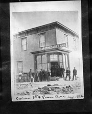
BUPC 2.1.24 is a smaller version of this photograph.
Images
Show Less

Brandon College campus from the north

http://archives.brandonu.ca/en/permalink/descriptions957
Part Of
Aerial views and campus photographs
Description Level
Item
GMD
graphic
Date Range
c. 1950s
Part Of
Aerial views and campus photographs
Description Level
Item
Series Number
2.1
Item Number
2.1.39
GMD
graphic
Date Range
c. 1950s
Physical Description
4.5" x 2.75" (b/w)
Scope and Content
View is southwest. Photograph shows: Clark Hall, the Brandon College Building and the Citizens' Science Building.
Images
Show Less

Brandon College ice skating rink

http://archives.brandonu.ca/en/permalink/descriptions959
Part Of
Aerial views and campus photographs
Description Level
Item
GMD
graphic
Date Range
c. 1920s/1930s
Part Of
Aerial views and campus photographs
Description Level
Item
Series Number
2.1
Item Number
2.1.43
GMD
graphic
Date Range
c. 1920s/1930s
Physical Description
6.25" x 4.5" (b/w)
Material Details
Photograph is a copy.
Scope and Content
View is west northwest, probably from the roof of the Brandon College Building. Photograph shows an ice skating rink located in the field west of the Brandon College Building and Clark Hall. Some houses are visible in the background.
Notes
Donated by: D. Sumner.
Images
Show Less

Aerial view: Brandon College looking west

http://archives.brandonu.ca/en/permalink/descriptions595
Part Of
Aerial views and campus photographs
Description Level
Item
GMD
graphic
Date Range
c. spring 1963
Part Of
Aerial views and campus photographs
Description Level
Item
Series Number
2.1
Item Number
2.1.3
GMD
graphic
Date Range
c. spring 1963
Physical Description
10" x 8" (b/w)
Scope and Content
View is west to McDiarmid Drive from approximately 16th Street between Princess and Louise Avenues. Photograph shows: Brandon College, Fleming School, Coronation Park, and West End Community Centre.
Images
Show Less

Aerial view: Brandon College Steam Plant

http://archives.brandonu.ca/en/permalink/descriptions596
Part Of
Aerial views and campus photographs
Description Level
Item
GMD
graphic
Date Range
c. spring 1963
Part Of
Aerial views and campus photographs
Description Level
Item
Series Number
2.1
Item Number
2.1.4
GMD
graphic
Date Range
c. spring 1963
Physical Description
10" x 8" (b/w)
Scope and Content
View is northwest from the corner of 18th Street and Louise Avenue. Photograph shows the Brandon College campus, the Steam Plant and Kinsmen Stadium. Flora Cowan Hall is under construction.
Images
Show Less

Aerial view: Brandon College and downtown east

http://archives.brandonu.ca/en/permalink/descriptions597
Part Of
Aerial views and campus photographs
Description Level
Item
GMD
graphic
Date Range
c. spring 1963
Part Of
Aerial views and campus photographs
Description Level
Item
Series Number
2.1
Item Number
2.1.5
GMD
graphic
Date Range
c. spring 1963
Physical Description
10" x 8" (b/w)
Scope and Content
View is east southeast from approximately 22nd Street between Princess and Louise Avenues. Photograph shows: Brandon College, Stanley Park, Park School, Prince Edward Hotel, First Baptist Church, First Presbyterian Church, Wheat City Arena, First Church United, St. Paul's, Central United Church.
Images
Show Less

Aerial view: Brandon College and downtown core

http://archives.brandonu.ca/en/permalink/descriptions598
Part Of
Aerial views and campus photographs
Description Level
Item
GMD
graphic
Date Range
c. spring 1963
Part Of
Aerial views and campus photographs
Description Level
Item
Series Number
2.1
Item Number
2.1.6
GMD
graphic
Date Range
c. spring 1963
Physical Description
10" x 8" (b/w)
Scope and Content
View is southeast from 21st Street and Princess Avenue. Photograph shows: Brandon College, Wheat City Arena, Armories, Reform (Knox) Church, Alexander School, Knox United Church, Kinsmen Playground, Kinsmen Stadium.
Images
Show Less

Aerial view: Brandon College looking northwest

http://archives.brandonu.ca/en/permalink/descriptions599
Part Of
Aerial views and campus photographs
Description Level
Item
GMD
graphic
Date Range
late 1960s
Part Of
Aerial views and campus photographs
Description Level
Item
Series Number
2.1
Item Number
2.1.7
GMD
graphic
Date Range
late 1960s
Physical Description
5" x 4" (b/w)
Scope and Content
Brandon College. Looking north west over the valley after 1963 Music Building opening, but before trees were moved to the quadrangle.
Images
Show Less

Aerial view: Brandon College tree planting

http://archives.brandonu.ca/en/permalink/descriptions604
Part Of
Aerial views and campus photographs
Description Level
Item
GMD
graphic
Date Range
c. 1964
Part Of
Aerial views and campus photographs
Description Level
Item
Series Number
2.1
Item Number
2.1.11
GMD
graphic
Date Range
c. 1964
Physical Description
5" x 4" (b/w)
Scope and Content
View is east northeast from approximately 22nd Street between Lorne and Louise Avenues. Photograph shows: Brandon College (before planting of trees in quadrangle and before the Education Building), McKenzie Seeds, Prince Edward Hotel, Central United (St. Paul's) Church, St. Augustine's Church.
Images
Show Less

Aerial view: Brandon College looking east

http://archives.brandonu.ca/en/permalink/descriptions617
Part Of
Aerial views and campus photographs
Description Level
Item
GMD
graphic
Date Range
c. 1963
Part Of
Aerial views and campus photographs
Description Level
Item
Series Number
2.1
Item Number
2.1.25
GMD
graphic
Date Range
c. 1963
Physical Description
5" x 4" (b/w)
Scope and Content
View is east from approximatley 22nd Street between Lorne and Louise Avenues. Photograph shows: Darrach Hall, Flora Cowan Hall and the Citizens' Science Building, as well as a number of homes in the area.
Images
Show Less

Apothecaries Hall, Brandon

http://archives.brandonu.ca/en/permalink/descriptions13947
Part Of
Fred McGuinness collection
Description Level
Item
GMD
graphic
Date Range
1882
Accession Number
1-2015
Part Of
Fred McGuinness collection
Description Level
Item
Series Number
McG 9
Item Number
1-2015.19
Accession Number
1-2015
GMD
graphic
Date Range
1882
Physical Description
5" x 4" (b/w)
Material Details
reproduction
Scope and Content
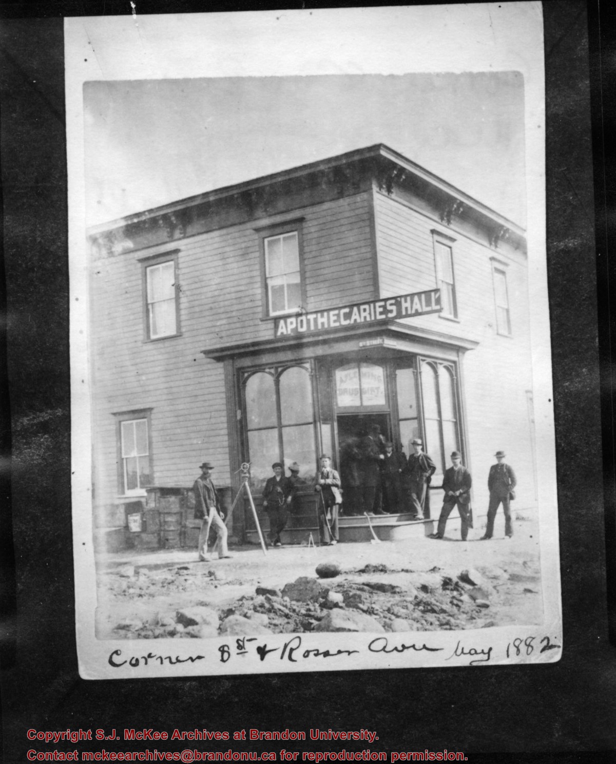
Photograph shows eight men posing in front of a wood-framed building on the corner of 8th Street and Rosser Avenue. Above the building's entrance is a painted sign that reads: Apothecaries' Hall. A. Fleming, Druggist is painted in the window above the door. Street signs designating 8th Street and Rosser Avenue are affixed to the building. A transit/theodolite is mounted on a tripod in front of the store.
Notes
Writing on the front of the photograph reads: Corner 8th St and Rosser Ave May 1882. Writing on the back of the photograph reads: Corner 8th St and Rosser, May 1882, Apthecaries' Hall, A. Fleming, Druggist. Photograph is stamped Public Archives Canada.
Name Access
A. Fleming
Apothecaries' Hall
Subject Access
Pioneers
surveying
druggists
store exteriors
Brandon business buildings & facilities before 1940
Storage Location
RG 5 photograph storage drawer 2 (hanging photos)
Related Material
LAC, Mikan 3194058
Arrangement
See McG 4.1 File 51 William R. Morrison correspondence dated 14 January 1985
Images
Show Less

Aerial view: Brandon College campus from north

http://archives.brandonu.ca/en/permalink/descriptions615
Part Of
Aerial views and campus photographs
Description Level
Item
GMD
graphic
Date Range
c. 1963
Part Of
Aerial views and campus photographs
Description Level
Item
Series Number
2.1
Item Number
2.1.23
GMD
graphic
Date Range
c. 1963
Physical Description
5" x 4" (b/w)
Scope and Content
View is north, taken from approximatley 19th Street and Rosser Avenue. Photograph shows: Clark Hall, the A.E. McKenzie Building, the J.R.C. Evans Lecture Theatre, H-Huts, Darrach Hall and Flora Cowan Hall, as well as a number of homes in the area.
Images
Show Less

Aerial view: Brandon College campus looking northwest

http://archives.brandonu.ca/en/permalink/descriptions616
Part Of
Aerial views and campus photographs
Description Level
Item
GMD
graphic
Date Range
c. 1963
Part Of
Aerial views and campus photographs
Description Level
Item
Series Number
2.1
Item Number
2.1.24
GMD
graphic
Date Range
c. 1963
Physical Description
5" x 4" (b/w)
Scope and Content
View is northwest from approximately the corner of 18th Street and Louise Avenue. Photograph shows the Brandon College campus after the completion of Flora Cowan Hall.
Notes
BUPC 2.1.20 is a larger version of this photograph.
Images
Show Less

Aerial view: Brandon College campus and Kinsmen Park

http://archives.brandonu.ca/en/permalink/descriptions621
Part Of
Aerial views and campus photographs
Description Level
Item
GMD
graphic
Date Range
c. 1962
Part Of
Aerial views and campus photographs
Description Level
Item
Series Number
2.1
Item Number
2.1.19
GMD
graphic
Date Range
c. 1962
Physical Description
10" x 8" (b/w)
Physical Condition
The bottom right hand corner has been torn off. Both portions of the photograph are stored together.
Scope and Content
View is northwest from approximately 17th Street and Victoria Avenue. Photograph shows: the Brandon College campus and the Kinsmen Park and baseball diamond. Taken during construction of Flora Cowan Hall but before the Gymnasium was built.
Images
Show Less

Brandon street cars in front of Winter Fair Building on 10th Street

http://archives.brandonu.ca/en/permalink/descriptions13753
Part Of
Fred McGuinness collection
Description Level
Item
GMD
graphic
Date Range
1913
Accession Number
20-2009
Part Of
Fred McGuinness collection
Description Level
Item
Series Number
McG 9
Item Number
20-2009.64
Accession Number
20-2009
GMD
graphic
Date Range
1913
Physical Description
5.5" x 3.5" (b/w)
Material Details
postcard
Physical Condition
Postcard is discoloured around the edges
History / Biographical
According to the Brandon Daily Sun (07 May 1913), the first three street cars (Nos. 10, 9, and 7) arrived in Brandon on the evening of May 6, 1913. The cars were shipped via Canadian National Rail to Brandon from Winnipeg and stored at the railway siding on McTavish Avenue between 8th and 9th Streets. The daily paper (15 May 1915) reported that a test run for the street cars was scheduled for May 16, 1913. The City Clerk published a public notice in the paper (29 May 1913) announcing the formal opening of the "Brandon Municipal Street Raily" for on Monday, June 2, from 2 p.m. to 4 p.m. at city hall where the cars would be displayed.
Custodial History
Donated to Fred McGuinness by Allena Strath (nee Coombs).
Scope and Content
Postcard depicts three municipal street cars parked on the 10th Street tracks in front of the Winter Fair Building. In front of the cars are a group of men wearing suits, hats, and top coats. Two automobiles are parked alongside the street cars. According to Archivist Emeritus Tom Mitchell, the group of men are members of the Brandon Municipal Street Railway Committee. The chairman of the committee, Harry Cater, can be seen in the center-left of the group wearing a watch fob. The committee had assembled for a test run of the street car service, which the Brandon Daily Sun reported to have occured on Sunday, May 16, 1913.
Notes
Back of postcard reads: First Street Car in Brandon in front of Winter Fair building 1910.
Name Access
Brandon Municipal Railway
Winter Fair Building
Harry Cater
10th Street
Subject Access
street cars
Transportation
cars
automobiles
Storage Location
RG 5 photograph storage drawer 2 (hanging photos)
Related Material
Lawrence Stuckey collection 1-2002.3.1I2
Images
Show Less

Fred McGuinness in college?

http://archives.brandonu.ca/en/permalink/descriptions14050
Part Of
Fred McGuinness collection
Description Level
Item
GMD
graphic
Date Range
[1940s]
Accession Number
1-2015
Part Of
Fred McGuinness collection
Description Level
Item
Series Number
McG 9
Item Number
1-2015.120
Accession Number
1-2015
GMD
graphic
Date Range
[1940s]
Physical Description
3.5" x 2.5" (b/w)
Scope and Content
Photograph shows Fred McGuinness posing with another man, possibly a fellow student at the University of Manitoba.
Name Access
Fred McGuinness
Frederick George McGuinness
Storage Location
RG 5 photograph storage drawer 2 (hanging photos)
Arrangement
BR #5 Family pictures
Images
Show Less

William Muir General Grocer building

http://archives.brandonu.ca/en/permalink/descriptions13757
Part Of
Fred McGuinness collection
Description Level
Item
GMD
graphic
Date Range
post-1888
Accession Number
20-2009
Part Of
Fred McGuinness collection
Description Level
Item
Series Number
McG 9
Item Number
20-2009.68
Accession Number
20-2009
GMD
graphic
Date Range
post-1888
Physical Description
4.5" x 7.5" (b/w)
Material Details
on matting
Physical Condition
Matting is bent and has a thumbtack hole.
History / Biographical
According to G.F. Barker (Brandon: A City, 1977, 291), William (Billy) Muir worked at Coombs & Stewart's on Pacific Avenue until he opened his own grocery store in 1888. The shop was located at 143-6th Street, Brandon, and was demolished for a parking lot in 1952.
Custodial History
Donated to Fred McGuinness by Allena Strath (nee Coombs).
Scope and Content
Photograph shows the "Wm. Muir General Grocer" building on 6th Street. Two men pose in the doorway of the store. The man on the left is likely William Muir. Barrels are lined on the boardwalk in front of the store. Apples and mason jars can be seen in the shop's windows.
Notes
Front of photograph reads: Sixth Street between Rosser - Princess. Back of photograph reads: Billy Muir's Store, 143 6th Street Brandon - 57 years in business in this location. An address label affixed to the back of the mat reads: Mrs. James Strath, Box 421, Souris, Man.
Name Access
Coombs & Stewart
Pacific Avenue
6th Street
Wm. Muir General Grocer
Subject Access
Pioneers
general stores
building exteriors
store exteriors
grocery stores
Brandon business buildings & facilities before 1940
Storage Location
RG 5 photograph storage drawer 2 (hanging photos)
Related Material
Lawrence Stuckey collection 1-2002.3.1E18
Images
Show Less

Building fire near rail yard

http://archives.brandonu.ca/en/permalink/descriptions14127
Part Of
Fred McGuinness collection
Description Level
Item
GMD
graphic
Date Range
[1960-1965]
Accession Number
1-2015
Part Of
Fred McGuinness collection
Description Level
Item
Series Number
McG 9
Item Number
1-2015.196
Accession Number
1-2015
GMD
graphic
Date Range
[1960-1965]
Physical Description
3" x 3" (b/w)
Scope and Content
Photograph shows a dark cloud of smoke emerging from a building or warehouse near a train yard.
Subject Access
fires
trains
railways
Storage Location
RG 5 photograph storage drawer 2 (hanging photos)
Arrangement
BR #3 Family photos
Images
Show Less

Building fire near rail yard

http://archives.brandonu.ca/en/permalink/descriptions14128
Part Of
Fred McGuinness collection
Description Level
Item
GMD
graphic
Date Range
[1960-1965]
Accession Number
1-2015
Part Of
Fred McGuinness collection
Description Level
Item
Series Number
McG 9
Item Number
1-2015.197
Accession Number
1-2015
GMD
graphic
Date Range
[1960-1965]
Physical Description
3" x 3" (b/w)
Scope and Content
Photograph shows a dark cloud of smoke emerging from a building or warehouse near a train yard.
Subject Access
fires
trains
railways
Storage Location
RG 5 photograph storage drawer 2 (hanging photos)
Arrangement
BR #3 Family photos
Images
Show Less

Aerial view: John R. Brodie Science Centre roof greenhouse

http://archives.brandonu.ca/en/permalink/descriptions608
Part Of
Aerial views and campus photographs
Description Level
Item
GMD
graphic
Date Range
c. 1970s
Part Of
Aerial views and campus photographs
Description Level
Item
Series Number
2.1
Item Number
2.1.15
GMD
graphic
Date Range
c. 1970s
Physical Description
8" x 10" (b/w)
Scope and Content
View is southeast and was probably taken from the roof of McMaster Hall. Photograph shows the greenhouse situated on top of the John R. Brodie Science Centre.
Images
Show Less

20 records – page 2 of 1.