Skip header and navigation

Revise Search

20 records – page 4 of 1.

Aerial view of Brandon postcard

http://archives.brandonu.ca/en/permalink/descriptions13867
Part Of
Fred McGuinness collection
Description Level
Item
GMD
graphic
Date Range
1970
Accession Number
20-2009
Part Of
Fred McGuinness collection
Creator
Photographer: R.J. "Bob" Snazel
Description Level
Item
Series Number
McG 9
Item Number
20-2009.177
Accession Number
20-2009
GMD
graphic
Date Range
1970
Physical Description
3.5" x 6" (colour)
Material Details
postcard
Scope and Content
Postcard shows an aerial view of the city of Brandon
Notes
Writing on the back of the postcard reads: No. 10. Brandon, Manitoba, Canada / Aerial View of Brandon / Distributed by Clements Drug Store / Brandon, Manitoba, Canada / Photos by: R.J. "Bob" Snazel. / Printed by: D.W. Friesen & Sons Ltd. Altona, Manitoba, Canada. The postcard is addressed to Mr. F.A. Rosser and is postmarked Brandon 30 May 1970. A 6-cent Queen Elizabeth red postage stamp portraying various modes of the transportation. The stamp has been cancelled with a postmark that reads "Help Retarded Children."
Name Access
City of Brandon
Subject Access
aerial photographs
aerial views
Repro Restriction
Canadian Copyright restrictions apply. Consult the Archivist.
Storage Location
RG 5 photograph storage drawer 2 (hanging photos)
Arrangement
From 20-2009 #1 File 13 Sunbeams
Images
Show Less

Brandon Mental Health Centre - Aerial View

http://archives.brandonu.ca/en/permalink/descriptions9645
Part Of
RG 11 Lawrence Stuckey fonds
Description Level
Item
GMD
graphic
Date Range
1977
Accession Number
1-2002
Part Of
RG 11 Lawrence Stuckey fonds
Description Level
Item
Series Number
3.1
Item Number
1-2002.3.1G14
Accession Number
1-2002
GMD
graphic
Date Range
1977
Physical Description
3 1/2" x 5"
Material Details
Negative
Custodial History
For custodial history see the collection level description of the Lawrence Stuckey collection.
Scope and Content
Brandon Mental Health Centre
Notes
Aerial view [looking north]
Name Access
Brandon Mental Health Centre
Subject Access
hospitals
psychiatric hospitals
Brandon Hospitals
Repro Restriction
The McKee Archives is the copyright holder for the Stuckey materials.
Storage Location
Lawrence Stuckey collection
Images
Show Less

9th Street aerial view facing south, Brandon, Manitoba

http://archives.brandonu.ca/en/permalink/descriptions8419
Part Of
Joseph H. Hughes collection
Description Level
Item
GMD
graphic
Date Range
c. 1940
Accession Number
3-1997
Part Of
Joseph H. Hughes collection
Creator
Photographer: Jerrett Photo
Description Level
Item
Series Number
3-1997.1
Item Number
3-1997.1.41
Accession Number
3-1997
GMD
graphic
Date Range
c. 1940
Physical Description
5.5" x 3.5" (b/w)
Material Details
postcard
Physical Condition
good
Scope and Content
Postcard shows an aerial view of 9th Street facing south in Brandon, Manitoba. Visible businesses and landmarks include: Beaubier Hotel, YMCA/police station, the original CKX Radio station towers on 8th Street (est. 1928 - moved 1940), the old City Hall, Prince Edward Hotel, and the original Manitoba Power commission smokestack on 10th Street.
Notes
Writing on the front of the photograph reads: Brandon, Man., Jerrett Photo. This photograph shows a rare view of the 800-block between Rosser and Princess Avenues.
Name Access
Beaubier Hotel
City Hall
CKX
Prince Edward Hotel
Manitoba Power Company
Subject Access
downtowns
street scenes
Brandon business buildings & facilities before 1940
aerial views
building exteriors
Storage Location
RG 5 photograph storage drawer
Images
Show Less

Aerial View of Downtown

http://archives.brandonu.ca/en/permalink/descriptions9283
Part Of
RG 11 Lawrence Stuckey fonds
Description Level
Item
GMD
graphic
Date Range
[196-]
Accession Number
1-2002
Part Of
RG 11 Lawrence Stuckey fonds
Description Level
Item
Series Number
3.1
Item Number
1-2002.3.1CA28
Accession Number
1-2002
GMD
graphic
Date Range
[196-]
Physical Description
3 1/2" x 5"
Material Details
Negative
Custodial History
For custodial history see the collection level description of the Lawrence Stuckey collection.
Scope and Content
Aerial view of downtown Brandon, including area of new Gallery Mall.
Notes
[This eastward aerial view of downtown Brandon seems to portray an outdoor second-story parking garage proposed by the architectural firm Ward, MacDonald and Partners. The proposed overhead parking is depicted as running continuously from Sixth Street to Tenth Street along Rosser Avenue. The negative appears to have been made by photographing an existing illustration. P.E. 03/06/09]
Name Access
Aerial View of Downtown
Subject Access
downtowns
businesses
merchants
Brandon Street Scenes After 1940
Repro Restriction
The McKee Archives is the copyright holder for the Stuckey materials.
Storage Location
Lawrence Stuckey collection
Images
Show Less

Aerial View of Core Area

http://archives.brandonu.ca/en/permalink/descriptions9267
Part Of
RG 11 Lawrence Stuckey fonds
Description Level
Item
GMD
graphic
Date Range
1977
Accession Number
1-2002
Part Of
RG 11 Lawrence Stuckey fonds
Creator
D.L. Bottley
Description Level
Item
Series Number
3.1
Item Number
1-2002.3.1CA19(1)
Accession Number
1-2002
GMD
graphic
Date Range
1977
Physical Description
3 1/2" x 5"
Material Details
Negative
Custodial History
For custodial history see the collection level description of the Lawrence Stuckey collection.
Scope and Content
Aerial view of Brandon's core area
Notes
[Mr. Stuckey put 2 negatives in the same envelope. We have separated them and numbered them CA19(1) and CA19(2).]
Name Access
Aerial View of Core Area
Subject Access
downtowns
aerial photography
Brandon Street Scenes After 1940
Repro Restriction
The McKee Archives is the copyright holder for the Stuckey materials.
Storage Location
Lawrence Stuckey collection
Images
Show Less

Aerial View of Core Area

http://archives.brandonu.ca/en/permalink/descriptions9268
Part Of
RG 11 Lawrence Stuckey fonds
Description Level
Item
GMD
graphic
Date Range
1977
Accession Number
1-2002
Part Of
RG 11 Lawrence Stuckey fonds
Creator
D.L. Bottley
Description Level
Item
Series Number
3.1
Item Number
1-2002.3.1CA19(2)
Accession Number
1-2002
GMD
graphic
Date Range
1977
Physical Description
3 1/2" x 5"
Material Details
Negative
Custodial History
For custodial history see the collection level description of the Lawrence Stuckey collection.
Scope and Content
Aerial view of Brandon's core area
Notes
[Mr. Stuckey put 2 negatives in the same envelope. We have separated them and numbered them CA19(1) and CA19(2).]
Name Access
Aerial View of Core Area
Subject Access
downtowns
aerial photography
Brandon Street Scenes After 1940
Repro Restriction
The McKee Archives is the copyright holder for the Stuckey materials.
Storage Location
Lawrence Stuckey collection
Images
Show Less

Brandon University campus

http://archives.brandonu.ca/en/permalink/descriptions7997
Part Of
Brandon University Photograph collection
Description Level
Item
GMD
graphic
Date Range
c. 1996
Part Of
Brandon University Photograph collection
Creator
Photographer: Sandy Black
Description Level
Item
Series Number
2.1
Item Number
BUPC 2.1.63
GMD
graphic
Date Range
c. 1996
Physical Description
6" x 4" (colour)
Scope and Content
View is northwest from the roof of the John R. Brodie Science Centre. Photograph shows the roof of the Knowles Douglas Students' Union Centre, the Citizens' Science Building, and the Brandon College Building and Clark Hall during renovation.
Subject Access
campus photographs
campus buildings
campus construction
Images
Show Less

Brandon University campus

http://archives.brandonu.ca/en/permalink/descriptions7998
Part Of
Brandon University Photograph collection
Description Level
Item
GMD
graphic
Date Range
c. 1993
Part Of
Brandon University Photograph collection
Description Level
Item
Series Number
2.1
Item Number
BUPC 2.1.64
GMD
graphic
Date Range
c. 1993
Physical Description
6" x 4" (colour)
Scope and Content
Photograph was taken from the roof of the Library and shows the walkway and flower bed on the southeast corner of the George T. Richardson Centre. The Physical Plant H-Hut is visible in the top right hand corner.
Subject Access
campus photographs
Images
Show Less

Brandon University campus

http://archives.brandonu.ca/en/permalink/descriptions7999
Part Of
Brandon University Photograph collection
Description Level
Item
GMD
graphic
Date Range
c. 1993
Part Of
Brandon University Photograph collection
Description Level
Item
Series Number
2.1
Item Number
BUPC 2.1.65
GMD
graphic
Date Range
c. 1993
Physical Description
4" x 6" (colour)
Scope and Content
View is southwest from the roof of the George T. Richardson Centre. Photograph shows the curved glass wall of the John E. Robbins Library, the walkway between the Library and the Dining Hall, the Dining Hall and Darrach Hall.
Subject Access
campus photographs
campus buildings
Images
Show Less

Brandon University campus

http://archives.brandonu.ca/en/permalink/descriptions8026
Part Of
Aerial views and campus photographs
Description Level
Item
GMD
graphic
Date Range
c. 1996
Part Of
Aerial views and campus photographs
Description Level
Item
Series Number
2.1
Item Number
2.1.93
GMD
graphic
Date Range
c. 1996
Physical Description
6" x 4" (colour)
Scope and Content
View is east northeast from the sidewalk on the southeast corner of the George T. Richardson Centre (John R. Robbins Library). Photographs shows the campus during winter, including the Physical Plant and Development H-Huts, as well as the Brandon College Building and Clark Hall after the majority of the renovations were completed.
Images
Show Less

Brandon University campus

http://archives.brandonu.ca/en/permalink/descriptions8027
Part Of
Aerial views and campus photographs
Description Level
Item
GMD
graphic
Date Range
c. 1985
Part Of
Aerial views and campus photographs
Description Level
Item
Series Number
2.1
Item Number
2.1.94
GMD
graphic
Date Range
c. 1985
Physical Description
5" x 3.5" (colour)
Scope and Content
View is southwest from 18th Street, just north of the Brandon University sign. Tken during the summer, the photograph shows the front lawn, a portion of the flower bed, the Citizens' Science Building, the Knowles Douglas Students' Union Centre, the John R. Brodie Science Centre and McMaster Hall.
Images
Show Less

Brandon University campus

http://archives.brandonu.ca/en/permalink/descriptions8028
Part Of
Aerial views and campus photographs
Description Level
Item
GMD
graphic
Date Range
c. 1980s
Part Of
Aerial views and campus photographs
Description Level
Item
Series Number
2.1
Item Number
2.1.95
GMD
graphic
Date Range
c. 1980s
Physical Description
5" x 3.5" (colour)
Scope and Content
View is northeast. Photograph shows the green space before the Library extension in 1993. Brandon College Building and the Development H-Hut in the background.
Images
Show Less

Brandon University campus

http://archives.brandonu.ca/en/permalink/descriptions8029
Part Of
Aerial views and campus photographs
Description Level
Item
GMD
graphic
Date Range
c. 1988
Part Of
Aerial views and campus photographs
Description Level
Item
Series Number
2.1
Item Number
2.1.96
GMD
graphic
Date Range
c. 1988
Physical Description
5" x 3.5" (colour)
Scope and Content
View is northwest from the roof of the John R. Brodie Science Centre. Photograph shows part of McMaster Hall, the H-Huts, the Citzens' Science Building, the Brandon College Building and Clark Hall, the driveway, the J.R.C. Evans Lecture Theatre, the A.E. McKenzie Building and the Queen Elizabeth II Music Building.
Images
Show Less

Brandon University campus

http://archives.brandonu.ca/en/permalink/descriptions8030
Part Of
Aerial views and campus photographs
Description Level
Item
GMD
graphic
Date Range
c. early 1990s
Part Of
Aerial views and campus photographs
Description Level
Item
Series Number
2.1
Item Number
2.1.97
GMD
graphic
Date Range
c. early 1990s
Physical Description
4" x 6" (b/w)
Scope and Content
View is north from the Knowles Douglas Students' Union Centre looking down the driveway toward Princess Avenue.
Images
Show Less

Brandon University campus

http://archives.brandonu.ca/en/permalink/descriptions8031
Part Of
Aerial views and campus photographs
Description Level
Item
GMD
graphic
Date Range
c. 1995
Part Of
Aerial views and campus photographs
Description Level
Item
Series Number
2.1
Item Number
2.1.98
GMD
graphic
Date Range
c. 1995
Physical Description
6" x 4" (colour)
Scope and Content
View is northwest from the sidewalk on the west side of 18th Street. Photograph shows the John R. Brodie Science Centre sign, McMaster Hall and its entrance, the lawn in from of McMaster Hall, a portion of the Knowles Douglas Students' Union Centre and the Citizens' Science Building.
Images
Show Less

Brandon University campus

http://archives.brandonu.ca/en/permalink/descriptions8032
Part Of
Aerial views and campus photographs
Description Level
Item
GMD
graphic
Date Range
c. 2000
Part Of
Aerial views and campus photographs
Creator
Photographer: Sandy Black
Description Level
Item
Series Number
2.1
Item Number
2.1.99
GMD
graphic
Date Range
c. 2000
Physical Description
6" x 4" (colour)
Scope and Content
View is southwest from the corner of Clark Hall and the Clark Hall extension. Photograph shows students entering and exiting the George T. Richardson Centre and walking through the courtyard.
Images
Show Less

Brandon University campus

http://archives.brandonu.ca/en/permalink/descriptions8033
Part Of
Aerial views and campus photographs
Description Level
Item
GMD
graphic
Date Range
c. 1990s
Part Of
Aerial views and campus photographs
Description Level
Item
Series Number
2.1
Item Number
2.1.101
GMD
graphic
Date Range
c. 1990s
Physical Description
4" x 6" (colour)
Scope and Content
View is south from appromately the skywalk. Photograph shows the walkway that runs in front of the A.E. McKenzie Building south to the George T. Richardson Centre staircase and entrance. McMaster Hall in the background.
Images
Show Less

Brandon University campus

http://archives.brandonu.ca/en/permalink/descriptions8034
Part Of
Aerial views and campus photographs
Description Level
Item
GMD
graphic
Date Range
c. 2000
Part Of
Aerial views and campus photographs
Creator
Photograph: Sandy Black
Description Level
Item
Series Number
2.1
Item Number
2.1.102
GMD
graphic
Date Range
c. 2000
Physical Description
4" x 6" (colour)
Scope and Content
View is north northeast from the roof of the John E. Robbins Library in the George T. Richardson Centre. Photograph shows the entrance to the Richardson Building, part of the courtyard and the Clark Hall extension.
Images
Show Less

Brandon University campus

http://archives.brandonu.ca/en/permalink/descriptions8035
Part Of
Aerial views and campus photographs
Description Level
Item
GMD
graphic
Date Range
c. 2000
Part Of
Aerial views and campus photographs
Creator
Photographer: Sandy Black
Description Level
Item
Series Number
2.1
Item Number
2.1.103
GMD
graphic
Date Range
c. 2000
Physical Description
6" x 4" (colour)
Scope and Content
View is northeast from in front of the John E. Robbins Library in the George T. Richardson Centre. Photograph shows the entrance to the Richardson Building, most of the courtyard, Clark Hall and its extension.
Images
Show Less

Brandon University campus

http://archives.brandonu.ca/en/permalink/descriptions8036
Part Of
Aerial views and campus photographs
Description Level
Item
GMD
graphic
Date Range
c. 2000
Part Of
Aerial views and campus photographs
Creator
Photographer: Sandy Black
Description Level
Item
Series Number
2.1
Item Number
2.1.104
GMD
graphic
Date Range
c. 2000
Physical Description
6" x 4" (colour)
Scope and Content
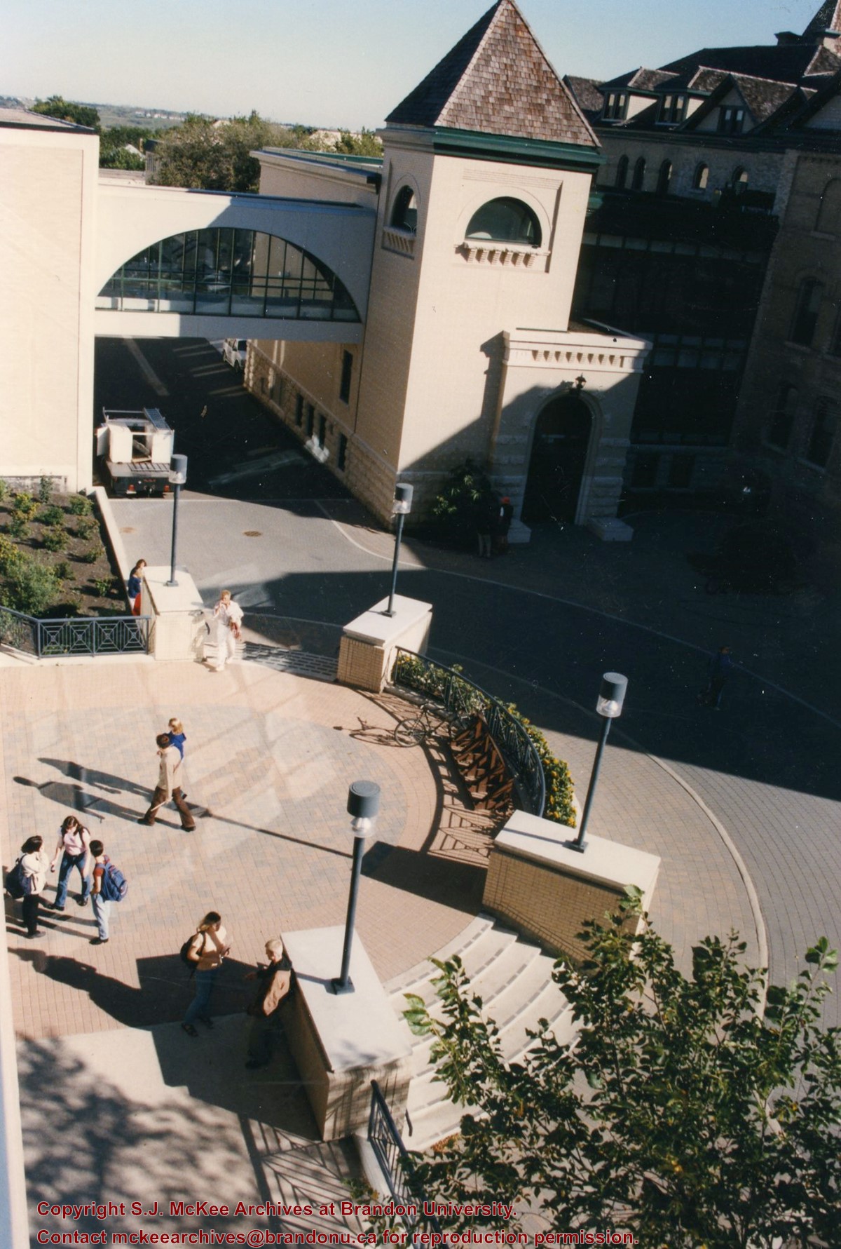
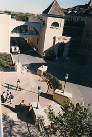
View is northeast from the roof of the George T. Richardson Centre (John E. Robbins Library). Photograph shows the courtyard and the west side of the Brandon College building and Clark Hall, as well as the Clark Hall extension and part of the skywalk.
Images
Show Less

20 records – page 4 of 1.