Skip header and navigation

Revise Search

20 records – page 4 of 1.

Brandon University campus front lawn

http://archives.brandonu.ca/en/permalink/descriptions772
Part Of
Aerial views and campus photographs
Description Level
Item
GMD
graphic
Date Range
May 1978
Part Of
Aerial views and campus photographs
Description Level
Item
Series Number
2.1
Item Number
2.1.32
GMD
graphic
Date Range
May 1978
Physical Description
5" x 3.5" (colour)
Scope and Content
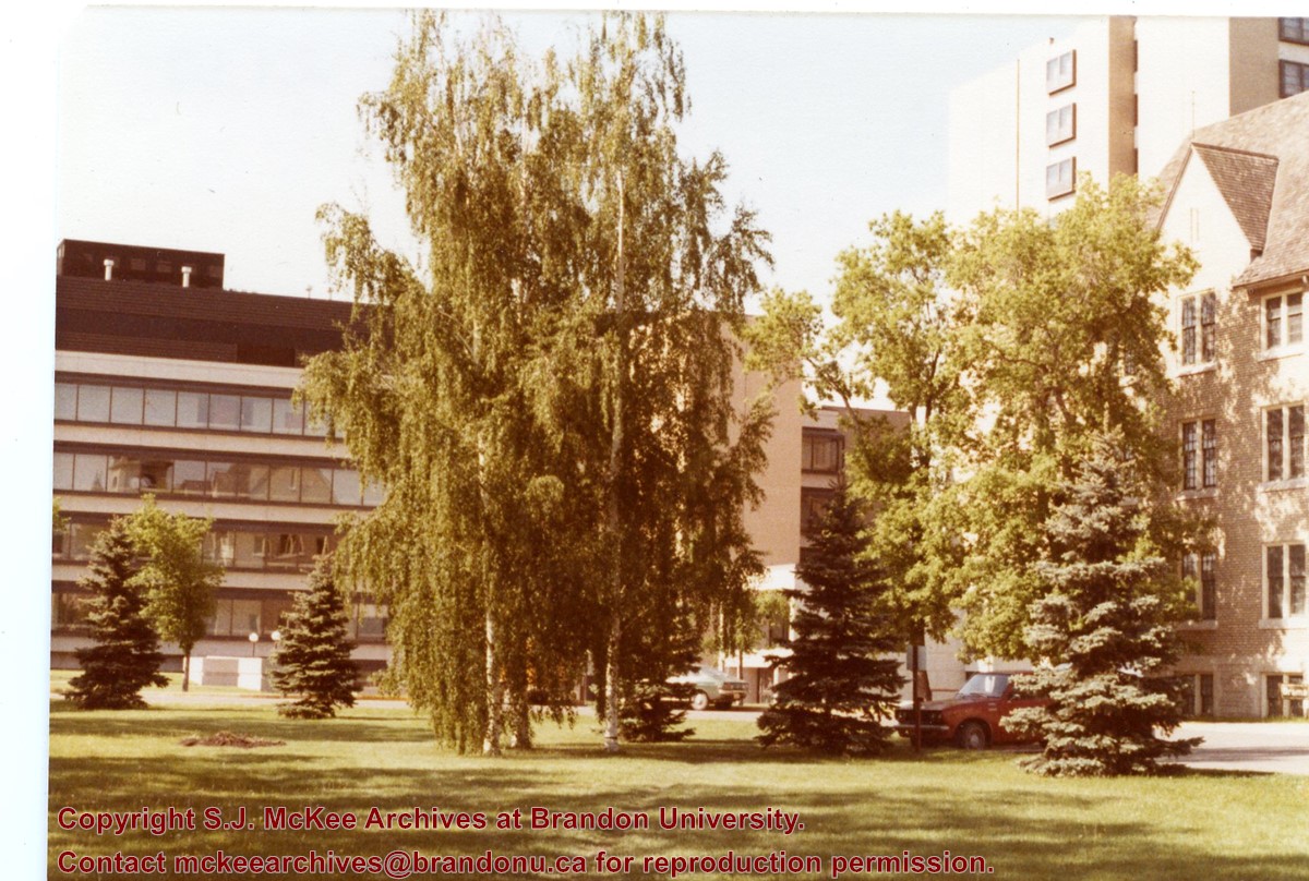
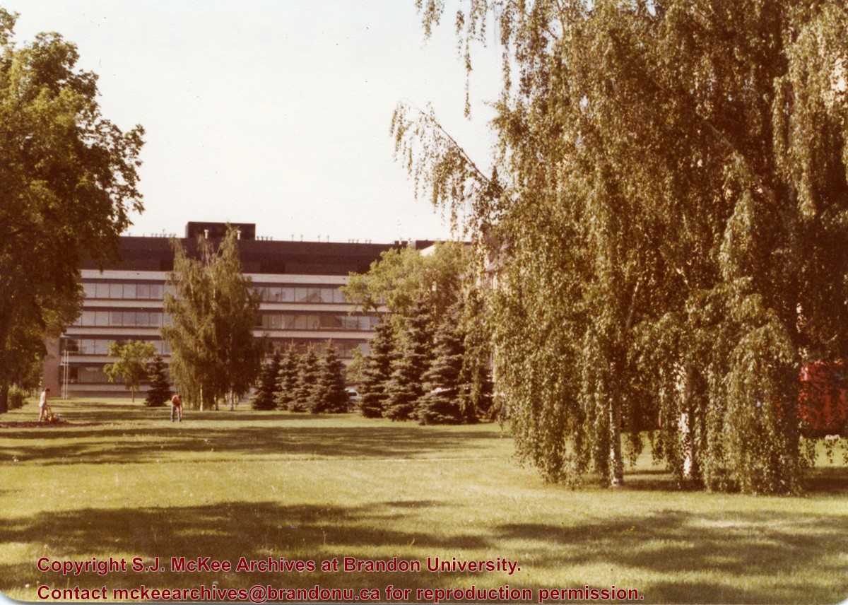
View is south southwest. Photograph shows the Brandon University campus front lawn in summer, with the John R. Brodie Science Centre, McMaster Hall, and the Citizens' Science Building in the background.
Images
Show Less

Brandon University campus front lawn

http://archives.brandonu.ca/en/permalink/descriptions774
Part Of
Aerial views and campus photographs
Description Level
Item
GMD
graphic
Date Range
May 1978
Part Of
Aerial views and campus photographs
Description Level
Item
Series Number
2.1
Item Number
2.1.33
GMD
graphic
Date Range
May 1978
Physical Description
5" x 3.5" (colour)
Scope and Content
View is south. Photograph shows the Brandon University campus front lawn in summer. The John R. Brodie Science Centre is in the background.
Images
Show Less

Brandon University campus front lawn flower gardens

http://archives.brandonu.ca/en/permalink/descriptions784
Part Of
Aerial views and campus photographs
Description Level
Item
GMD
graphic
Date Range
May 1978
Part Of
Aerial views and campus photographs
Description Level
Item
Series Number
2.1
Item Number
2.1.34
GMD
graphic
Date Range
May 1978
Physical Description
5" x 3.5" (colour)
Scope and Content
Photograph shows the flower bed on the front lawn of the Brandon Unviersity campus.
Images
Show Less

Aerial view: Brandon College Building

http://archives.brandonu.ca/en/permalink/descriptions606
Part Of
Aerial views and campus photographs
Description Level
Item
GMD
graphic
Date Range
c. 1988
Part Of
Aerial views and campus photographs
Description Level
Item
Series Number
2.1
Item Number
2.1.13
GMD
graphic
Date Range
c. 1988
Physical Description
3.5" x 5" (colour)
Scope and Content
View is north northeast. Photograph shows the Brandon College Building in the foreground with the Education Building and North Hill in the background. Photo was taken from the roof of McMaster Hall.
Images
Show Less

Aerial view: Brandon College looking west

http://archives.brandonu.ca/en/permalink/descriptions595
Part Of
Aerial views and campus photographs
Description Level
Item
GMD
graphic
Date Range
c. spring 1963
Part Of
Aerial views and campus photographs
Description Level
Item
Series Number
2.1
Item Number
2.1.3
GMD
graphic
Date Range
c. spring 1963
Physical Description
10" x 8" (b/w)
Scope and Content
View is west to McDiarmid Drive from approximately 16th Street between Princess and Louise Avenues. Photograph shows: Brandon College, Fleming School, Coronation Park, and West End Community Centre.
Images
Show Less

Aerial view: Brandon College Steam Plant

http://archives.brandonu.ca/en/permalink/descriptions596
Part Of
Aerial views and campus photographs
Description Level
Item
GMD
graphic
Date Range
c. spring 1963
Part Of
Aerial views and campus photographs
Description Level
Item
Series Number
2.1
Item Number
2.1.4
GMD
graphic
Date Range
c. spring 1963
Physical Description
10" x 8" (b/w)
Scope and Content
View is northwest from the corner of 18th Street and Louise Avenue. Photograph shows the Brandon College campus, the Steam Plant and Kinsmen Stadium. Flora Cowan Hall is under construction.
Images
Show Less

Aerial view: Brandon College and downtown east

http://archives.brandonu.ca/en/permalink/descriptions597
Part Of
Aerial views and campus photographs
Description Level
Item
GMD
graphic
Date Range
c. spring 1963
Part Of
Aerial views and campus photographs
Description Level
Item
Series Number
2.1
Item Number
2.1.5
GMD
graphic
Date Range
c. spring 1963
Physical Description
10" x 8" (b/w)
Scope and Content
View is east southeast from approximately 22nd Street between Princess and Louise Avenues. Photograph shows: Brandon College, Stanley Park, Park School, Prince Edward Hotel, First Baptist Church, First Presbyterian Church, Wheat City Arena, First Church United, St. Paul's, Central United Church.
Images
Show Less

Aerial view: Brandon College and downtown core

http://archives.brandonu.ca/en/permalink/descriptions598
Part Of
Aerial views and campus photographs
Description Level
Item
GMD
graphic
Date Range
c. spring 1963
Part Of
Aerial views and campus photographs
Description Level
Item
Series Number
2.1
Item Number
2.1.6
GMD
graphic
Date Range
c. spring 1963
Physical Description
10" x 8" (b/w)
Scope and Content
View is southeast from 21st Street and Princess Avenue. Photograph shows: Brandon College, Wheat City Arena, Armories, Reform (Knox) Church, Alexander School, Knox United Church, Kinsmen Playground, Kinsmen Stadium.
Images
Show Less

Aerial view: Brandon College looking northwest

http://archives.brandonu.ca/en/permalink/descriptions599
Part Of
Aerial views and campus photographs
Description Level
Item
GMD
graphic
Date Range
late 1960s
Part Of
Aerial views and campus photographs
Description Level
Item
Series Number
2.1
Item Number
2.1.7
GMD
graphic
Date Range
late 1960s
Physical Description
5" x 4" (b/w)
Scope and Content
Brandon College. Looking north west over the valley after 1963 Music Building opening, but before trees were moved to the quadrangle.
Images
Show Less

Aerial view: Brandon College tree planting

http://archives.brandonu.ca/en/permalink/descriptions604
Part Of
Aerial views and campus photographs
Description Level
Item
GMD
graphic
Date Range
c. 1964
Part Of
Aerial views and campus photographs
Description Level
Item
Series Number
2.1
Item Number
2.1.11
GMD
graphic
Date Range
c. 1964
Physical Description
5" x 4" (b/w)
Scope and Content
View is east northeast from approximately 22nd Street between Lorne and Louise Avenues. Photograph shows: Brandon College (before planting of trees in quadrangle and before the Education Building), McKenzie Seeds, Prince Edward Hotel, Central United (St. Paul's) Church, St. Augustine's Church.
Images
Show Less

Aerial view: Brandon College looking east

http://archives.brandonu.ca/en/permalink/descriptions617
Part Of
Aerial views and campus photographs
Description Level
Item
GMD
graphic
Date Range
c. 1963
Part Of
Aerial views and campus photographs
Description Level
Item
Series Number
2.1
Item Number
2.1.25
GMD
graphic
Date Range
c. 1963
Physical Description
5" x 4" (b/w)
Scope and Content
View is east from approximatley 22nd Street between Lorne and Louise Avenues. Photograph shows: Darrach Hall, Flora Cowan Hall and the Citizens' Science Building, as well as a number of homes in the area.
Images
Show Less

Aerial view: Brandon College and Original Music Building

http://archives.brandonu.ca/en/permalink/descriptions603
Part Of
Aerial views and campus photographs
Description Level
Item
GMD
graphic
Date Range
c. 1965
Part Of
Aerial views and campus photographs
Description Level
Item
Series Number
2.1
Item Number
2.1.10
GMD
graphic
Date Range
c. 1965
Physical Description
5" x 4" (b/w)
Scope and Content
View is west southwest from 17th Street and Princess Avenue. Photograph shows: Clark Hall, A.E. McKenzie Building and original Music Building.
Images
Show Less

Brandon College campus

http://archives.brandonu.ca/en/permalink/descriptions727
Part Of
Aerial views and campus photographs
Description Level
Item
GMD
graphic
Date Range
c. 1961
Part Of
Aerial views and campus photographs
Description Level
Item
Series Number
2.1
Item Number
2.1.145
GMD
graphic
Date Range
c. 1961
Physical Description
3.5" x 5" (colour)
Material Details
Kodak paper
Scope and Content
Photograph is looking northwest probably from the northwest corner of 18th Street and Louise Avenue. The photographer was laying down when s/he took the shot. Photograph shows the field to the south of the Citizens' Science Building, as well as the Citizens' Science Building, part of the Brandon College Building and Clark Hall, and two H-Huts. The photo was taken in summer as the field is full of dandelions.
Images
Show Less

Brandon College campus

http://archives.brandonu.ca/en/permalink/descriptions819
Part Of
Aerial views and campus photographs
Description Level
Item
GMD
graphic
Date Range
c. 1960s
Part Of
Aerial views and campus photographs
Description Level
Item
Series Number
2.1
Item Number
2.1.51
GMD
graphic
Date Range
c. 1960s
Physical Description
10" x 8" (b/w)
Scope and Content
View is southwest. Photograph shows Clark Hall, the Brandon College Building, the Citizens' Science Building and the driveway running in front of the buildings. Portions of the front lawn and the Kinsmen Staduim are also visible.
Images
Show Less

Brandon College campus

http://archives.brandonu.ca/en/permalink/descriptions916
Part Of
Aerial views and campus photographs
Description Level
Item
GMD
graphic
Date Range
c. 1966
Part Of
Aerial views and campus photographs
Creator
Miles Photos
Description Level
Item
Series Number
2.1
Item Number
2.1.53
GMD
graphic
Date Range
c. 1966
Physical Description
10" x 8" (b/w)
Scope and Content
View is northwest from the front lawn. Photograph shows the Citizens' Science Building, an H-Hut, the Brandon College Building, Clark Hall and the original Music Building.
Images
Show Less

Brandon College campus

http://archives.brandonu.ca/en/permalink/descriptions11640
Part Of
CKX fonds
Description Level
Item
GMD
graphic
Date Range
c. 1960
Accession Number
11-2010
Part Of
CKX fonds
Creator
CKX
Description Level
Item
Item Number
11-2010.B129k
Accession Number
11-2010
GMD
graphic
Date Range
c. 1960
Physical Description
5" x 4" (b/w)
Material Details
Negative
Custodial History
See fonds level of the CKX records for custodial history.
Scope and Content
Image is looking southwest across Brandon College campus. Visible are Clark Hall, the Brandon College Building, the Citizens' Science Building and the A.E. McKenzie Building.
Name Access
CKX Television
Brandon College
Subject Access
public buildings
colleges
Storage Location
CKX fonds - 2010 accessions
Images
Show Less

Brandon College campus

http://archives.brandonu.ca/en/permalink/descriptions11645
Part Of
CKX fonds
Description Level
Item
GMD
graphic
Date Range
c. 1955
Accession Number
11-2010
Part Of
CKX fonds
Creator
CKX
Description Level
Item
Item Number
11-2010.B129l
Accession Number
11-2010
GMD
graphic
Date Range
c. 1955
Physical Description
5" x 4" (b/w)
Material Details
Negative
Custodial History
See fonds level of the CKX records for custodial history.
Scope and Content
Image is looking northwest across Brandon College campus. Visible are the H-Huts and the Citizen's Science Building. Behind the Citizen's Science Building are the Brandon College Building and Clark Hall.
Name Access
CKX Television
Brandon College
Subject Access
public buildings
colleges
Storage Location
CKX fonds - 2010 accessions
Images
Show Less

Brandon College campus

http://archives.brandonu.ca/en/permalink/descriptions11648
Part Of
CKX fonds
Description Level
Item
GMD
graphic
Date Range
c. 1955
Accession Number
11-2010
Part Of
CKX fonds
Creator
CKX
Description Level
Item
Item Number
11-2010.B129m
Accession Number
11-2010
GMD
graphic
Date Range
c. 1955
Physical Description
5" x 4" (b/w)
Material Details
Negative
Custodial History
See fonds level of the CKX records for custodial history.
Scope and Content
Image is looking south southwest across Brandon College campus. Visible are Clark Hall, the Brandon College Building and the Citizens' Science Building.
Name Access
CKX Television
Brandon College
Subject Access
public buildings
colleges
Storage Location
CKX fonds - 2010 accessions
Images
Show Less

Brandon College campus

http://archives.brandonu.ca/en/permalink/descriptions11657
Part Of
CKX fonds
Description Level
Item
GMD
graphic
Date Range
c. 1960
Accession Number
11-2010
Part Of
CKX fonds
Creator
CKX
Description Level
Item
Item Number
11-2010.B129t
Accession Number
11-2010
GMD
graphic
Date Range
c. 1960
Physical Description
5" x 4" (b/w)
Material Details
Negative
Custodial History
See fonds level of the CKX records for custodial history.
Scope and Content
Image is looking southwest across Brandon College campus. Visible are the Dining Room and parts of the A.E. McKenzie Building and Darrach Hall.
Name Access
CKX Television
Brandon College
Subject Access
public buildings
colleges
Storage Location
CKX fonds - 2010 accessions
Images
Show Less

Brandon College campus

http://archives.brandonu.ca/en/permalink/descriptions11658
Part Of
CKX fonds
Description Level
Item
GMD
graphic
Date Range
c. 1960
Accession Number
11-2010
Part Of
CKX fonds
Creator
CKX
Description Level
Item
Item Number
11-2010.B129u
Accession Number
11-2010
GMD
graphic
Date Range
c. 1960
Physical Description
5" x 4" (b/w)
Material Details
Negative
Custodial History
See fonds level of the CKX records for custodial history.
Scope and Content
Image is looking northwest across Brandon College campus. Visible is part of an H-Hut, the J.R.C. Evans Lecture Theatre and the A.E. McKenzie Building.
Name Access
CKX Television
Brandon College
Subject Access
public buildings
colleges
Storage Location
CKX fonds - 2010 accessions
Images
Show Less

20 records – page 4 of 1.