View is southeast from approximatley 23rd Street and Rosser Avenue. Photograph shows the Brandon University campus, Kinsmen Stadium, Earl Oxford school, the Fair Grounds (including the Grandstand and Racetrack) and a number of residential blocks, particularly in the southeast part of the city.
View is west from 17th Street between Louise and Princess Avenues. Photograph shows the Brandon University Campus, Fleming School and Coronation Park, as well as a number of residential blocks.
View is south southeast from approsimatley Rosser Avenue and 21st Street. Photograph shows the Brandon University campus, Kinsmen Stadium, Earl Oxford School, the Fair Grounds (including the Grand Stand and Race Track), and a number of residential blocks.
View is south southwest from approximatley the southwest corner of 18th Street and Princess Avenue. Photograph shows the University campus, Kinsmen Stadium, Earl Oxford School and residential blocks.
View is west from 17th Street between Louise and Princess Avenues to approximalety 25th Street. Photograph shows the University campus, Fleming School, Coronation Park and residential blocks.
View is southeast from north of the corner of Princess Avenue and 22nd Street to approximatley Brandon Avenue. Photograph shows the University campus, Kinsmen Stadium, Earl Oxford School, and residential blocks. Brandon Collegiate Institute (BCI) is visible in the upper left corner.
View is west southwest from approximatley the northside of Princess Avenue just east of 18th Street. Photograph shows the University campus, part of Kinsmen Stadium and residential blocks.
View is northwest from approximatley the southeast corner of 18th Street and Louise Avenue. Photograph shows the University campus and residential blocks.
View is southwest from approximatley the corner of 17th Street and Princess Avenue to McDiarmid Drive. Photograph shows the Brandon University campus, Kinsmen Stadium, Fleming School, Coronation Park and residential blocks.
View is west northwest from aproximatley 15th Street and Louise Avenue to 34th Street. Photograph shows the Brandon University campus, part of Kinsmen Stadium, Fleming School, Coronoation Park, Valleyview Centennial School, Sacred Heart School ?, and residential blocks.
View is west northwest from aproximatley 16th Street and Louise Avenue to west of 34th Street. Photograph shows the Brandon University campus, part of Kinsmen Stadium, Coronoation Park, Valleyview Centennial School, part of the Assiniboine River and residential blocks.
View is southwest from approximatley 16th Street between Lorne Avenue and Princess Avenue. The view extends to approximately 26th Street. Photograph shows the Brandon University campus, Kinsmen Stadium, Fleming School, Coronation Park and residential blocks.
View is southwest from approximatley 16th Street and Princess Avenue to McDiarmid Drive. Photograph shows the Brandon University campus, Kinsmen Stadium, Fleming School, Coronation Park, J.R. Ried School and residential blocks.
Postcard is of buildings at Brandon University, including Clark Hall and the Original Building prior to the renovations, McMasater Hall, and the Q.E.II School of Music building.
Notes
Writing on the front of the postcard reads: Brandon University. Back of the postcard reads: (Top Left) Brandon University original building (Administration Center.), Bottom Left) Queen Elizabeth II Music Building, (Right) McMaster Hall Residence; Photo by Sandy Black; Printed in Brandon, Manitoba, Canada, by Leech Printing Ltd.
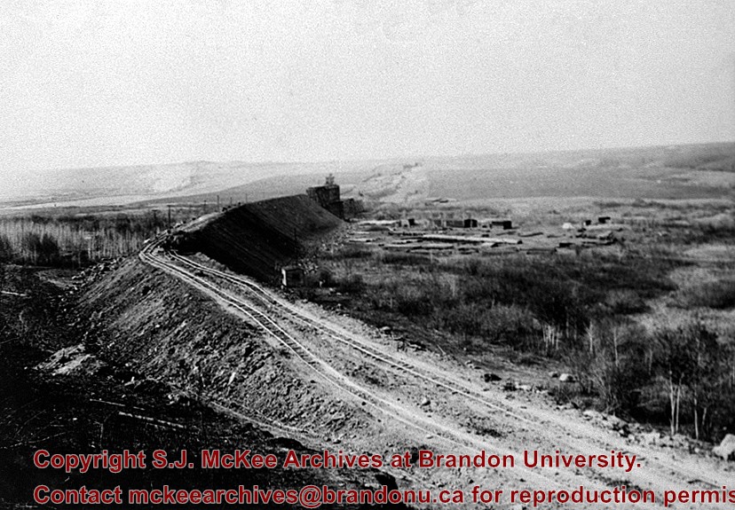
According to Stuckey and Bain (1996), “The Brandon, Saskatchewan & Hudson’s Bay Railway was built and operated as a totally owned subsidiary of the Great Northern Railway. Construction commenced in late 1905 and by the end of 1905, less than a mile of track had been laid north of the boundary at St. John. In 1906, the remaining 68.6 miles to Brandon were laid and service commenced that year. During the Depression of the 1930s, traffic declined significantly and the entire branch was abandoned in 1936. Over much of the branch’s length, the ties and rails were laid on the prairie without ballast and today little remains of the line apart from traces where there were cuts and bridges.” (p. 18)
Stuckey, L. A., & Bain, D. M. (1996). The Great Northern and Northern Pacific railways in Canada. Calgary, Alberta: British Railway Modellers of North America.
Custodial History
For custodial history see the collection level description of the Lawrence Stuckey collection.
Scope and Content
View of the Great Northern (BS&HB) Railway building a grade [to their bridge] at Bunclody, Manitoba.
Notes
[This railway bridge crossed the Souris River. P.E.]
From the collection of Gilford Copeland of Bunclody, Manitoba
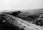
According to Stuckey and Bain (1996), “The Brandon, Saskatchewan & Hudson’s Bay Railway was built and operated as a totally owned subsidiary of the Great Northern Railway. Construction commenced in late 1905 and by the end of 1905, less than a mile of track had been laid north of the boundary at St. John. In 1906, the remaining 68.6 miles to Brandon were laid and service commenced that year. During the Depression of the 1930s, traffic declined significantly and the entire branch was abandoned in 1936. Over much of the branch’s length, the ties and rails were laid on the prairie without ballast and today little remains of the line apart from traces where there were cuts and bridges.” (p. 18)
Stuckey, L. A., & Bain, D. M. (1996). The Great Northern and Northern Pacific railways in Canada. Calgary, Alberta: British Railway Modellers of North America.
Custodial History
For custodial history see the collection level description of the Lawrence Stuckey collection.
Scope and Content
View of the Great Northern (BS&HB) Railway building a grade [to their bridge] at Bunclody, Manitoba.
Notes
Grading station site
From the collection of Gilford Copeland of Bunclody, Manitoba
View is north northwest from the John R. Brodie Science Center (?). Photograph shows: Citizens' Science Building, Brandon College Building and Clark Hall, the Education Building and the driveway running in front of the buildings.
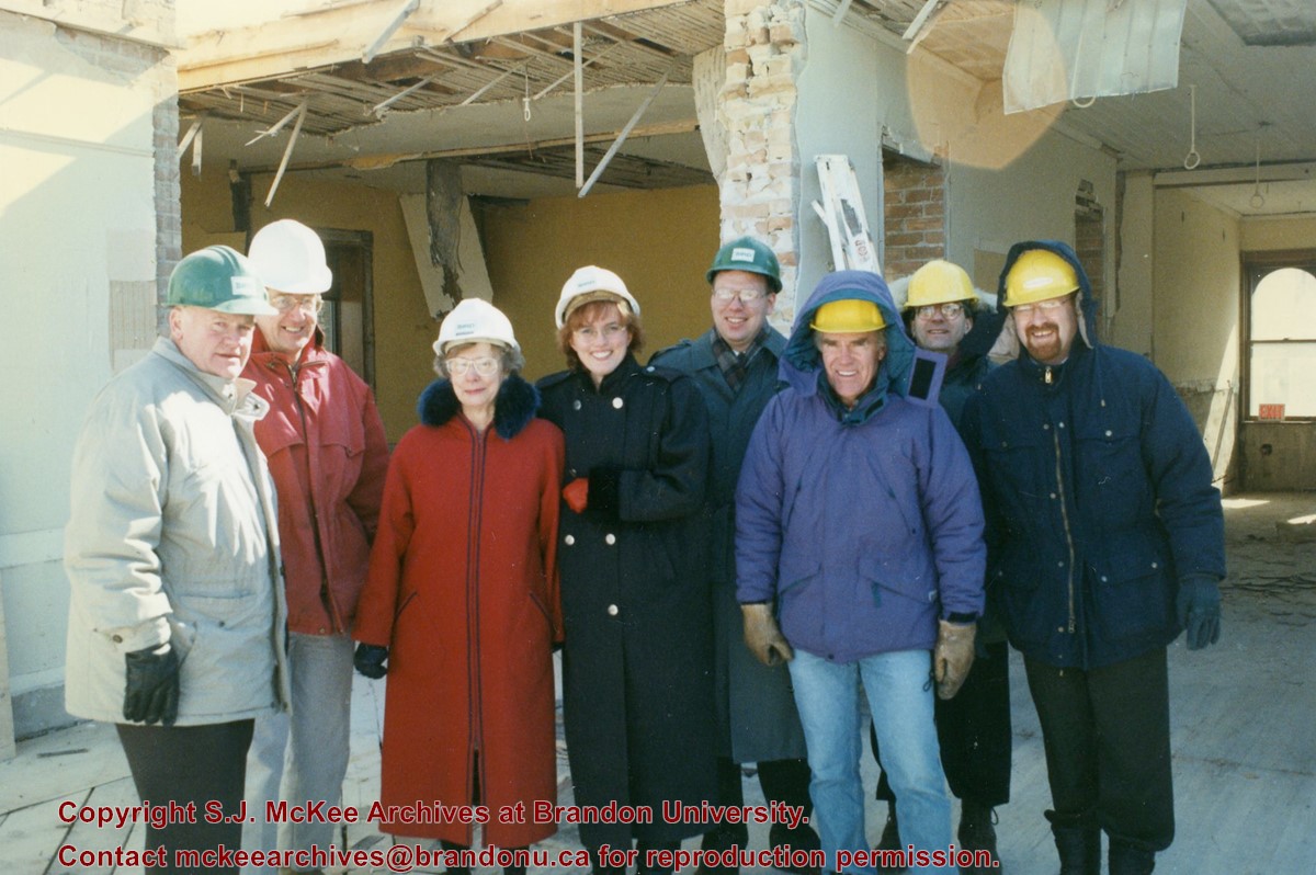
Photograph shows members of the Brandon University Foundation during a tour of the construction site. Members include: Scott Stewart, Doug Adams, Sheri Decter-Hirst.


+Railway+Bridge+at+Bunclody+-+Grade)
+Railway+Bridge+at+Bunclody+-+Grading+Station)