Skip header and navigation

Revise Search

20 records – page 2 of 1.

CPR station looking west from overhead bridge

http://archives.brandonu.ca/en/permalink/descriptions8778
Part Of
RG 11 Lawrence Stuckey fonds
Description Level
Item
GMD
graphic
Date Range
1908
Accession Number
1-2002
Part Of
RG 11 Lawrence Stuckey fonds
Creator
Frank Gowen
Description Level
Item
Series Number
3.9
Item Number
1-2002.3.9.153
Accession Number
1-2002
GMD
graphic
Date Range
1908
Physical Description
7.5" x 4.5" (b/w)
History / Biographical
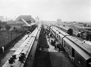
Stuckey's notes: Date determination: Engine 93, ex 375 received Series 2 numbering Sept. 1907 and repainting is still clean; some trees have leaves so could be Sept. 1907 but more likely about May 1908.
Scope and Content
Photograph is looking west along the CPR tracks. Trains at the station have both freight and passenger cars - freight and baggage is being loaded, while people are both arriving and departing.
Notes
Corresponds with negative 1-2002.3.9.P8.
Repro Restriction
The McKee Archives is the copyright holder for the Stuckey materials.
Location Original
1-2002.3.1P8
Storage Location
RG 5 photograph storage drawer
Images
Show Less

CPR yards, looking west from coal dock

http://archives.brandonu.ca/en/permalink/descriptions8785
Part Of
RG 11 Lawrence Stuckey fonds
Description Level
Item
GMD
graphic
Date Range
September 1938
Accession Number
1-2002
Part Of
RG 11 Lawrence Stuckey fonds
Creator
Photographer: George H. Harris
Description Level
Item
Series Number
3.9
Item Number
1-2002.3.9.160
Accession Number
1-2002
GMD
graphic
Date Range
September 1938
Physical Description
9.5" x 6.5" (b/w)
History / Biographical
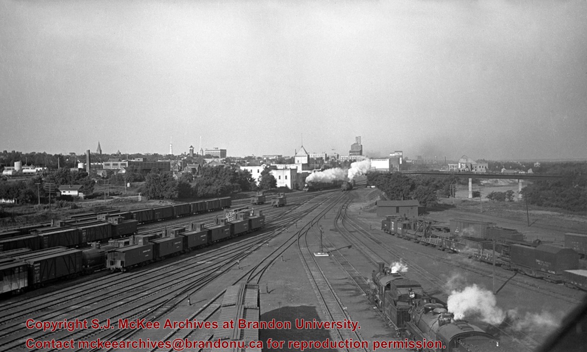
Stuckey's notes: No. 54 Moose Jaw - Winnipeg Local is leaving (just E. of 1st St. Bridge). Original negative. Collection of George H. Harris, Winnipeg, Man
Scope and Content
Photograph is looking west southwest along the CPR tracks.
Notes
Corresponds with negative 1-2002.3.9.P16.
Repro Restriction
The McKee Archives is the copyright holder for the Stuckey materials.
Location Original
1-2002.3.1P16
Storage Location
RG 5 photograph storage drawer
Images
Show Less

Tenth Street looking towards CPR Station, Brandon, Man.

http://archives.brandonu.ca/en/permalink/descriptions13780
Part Of
Fred McGuinness collection
Description Level
Item
GMD
graphic
Date Range
[1917-1919]
Accession Number
20-2009
Part Of
Fred McGuinness collection
Description Level
Item
Series Number
McG 9
Item Number
20-2009.91
Accession Number
20-2009
GMD
graphic
Date Range
[1917-1919]
Physical Description
5.5" x 3.5" (colour)
Material Details
postcard
History / Biographical
According to Russ Gourluck (Silver Screens on the Prairie, Winnipeg: Great Plains Publications, 2012, 26), the Orpheum Theatre was in operation from 1917 to 1920 when it then became the Willis Theatre.
Scope and Content
Postcard shows the 100 block of 10th Street facing north. The CPR train station can be seen at the end of 10th Street. The sign for the Rex Cafe is visible on the west side of 10th Street. On the east side of 10th Street, billboards for Campbell & Campbell furniture are visible as well as signs for Pianos and the Orpheum Theatre. Motorists and cyclists share the road. Street car tracks run the length of 10th Street.
Notes
Postcard was manufactured by T.B. [Tichnor Brothers, Inc., 1908-1987] Cambridge, Massachusetts.
Name Access
10th Street
CPR Station
Orpheum Theatre
Rex Cafe
Campbell & Campbell
Brandon Municipal Railway
Subject Access
street scenes
building exteriors
store exteriors
automobiles
Transportation
street cars
bicycles
Storage Location
RG 5 photograph storage drawer 2 (hanging photos)
Images
Show Less

Donald Street looking south from Portage Avenue, Winnipeg

http://archives.brandonu.ca/en/permalink/descriptions14055
Part Of
Fred McGuinness collection
Description Level
Item
GMD
graphic
Date Range
1927
Accession Number
1-2015
Part Of
Fred McGuinness collection
Creator
Printer: Valentine
Description Level
Item
Series Number
McG 9
Item Number
1-2015.125
Accession Number
1-2015
GMD
graphic
Date Range
1927
Physical Description
3.5" x 5.5" (colour)
Material Details
postcard
Scope and Content
Postcard shows a street scene of Donald Street looking south from the Portage Avenue Intersection.
Notes
Writing on the back of the postcard reads: Aug 9, Dear ruth, Aunt Eva, Aunt Annie and Fred were over to the bowlnig greens tonight. Every one fine. Doddy. Postcard is addressed to Ruth McGuinness, 337-17th St., Brandon, Man. Postmarked: Winnipeg 12 PM Aug 10 1927 Man.
Name Access
Winnipeg
Subject Access
street scenes
street cars
streetcars
Transportation
Storage Location
RG 5 photograph storage drawer 2 (hanging photos)
Arrangement
McG 1.1 file 17
Images
Show Less

Granaries, northwest of Douglas

http://archives.brandonu.ca/en/permalink/descriptions10914
Part Of
RG 11 Lawrence Stuckey fonds
Description Level
Item
GMD
graphic
Date Range
July 24, 1977
Accession Number
1-2002
Part Of
RG 11 Lawrence Stuckey fonds
Creator
L.A. Stuckey
Description Level
Item
Series Number
3.3
Item Number
1-2002.3.3.BNE[322]
Accession Number
1-2002
GMD
graphic
Date Range
July 24, 1977
Physical Description
2.25" x 2.25" (b/w)
Material Details
Negative
Custodial History
For custodial history see the collection level description of the Lawrence Stuckey collection.
Scope and Content
Image of granaries, northwest of Douglas.
Notes
[Brandon NE includes communities north of Trans-Canada #1 highway and east of PTH #10.]
Name Access
Douglas, Manitoba
Subject Access
granaries
Repro Restriction
The McKee Archives is the copyright holder of the Stuckey materials.
Storage Location
Lawrence Stuckey collection
Images
Show Less

Lorne Avenue, looking west from St. Augustine's Church postcard

http://archives.brandonu.ca/en/permalink/descriptions13937
Part Of
Fred McGuinness collection
Description Level
Item
GMD
graphic
Date Range
1952
Accession Number
1-2015
Part Of
Fred McGuinness collection
Creator
Photograph by: J.V.
Description Level
Item
Series Number
McG 9
Item Number
1-2015.9
Accession Number
1-2015
GMD
graphic
Date Range
1952
Physical Description
5.5" x 3.5" (colour)
Material Details
postcard
Scope and Content
Photograph shows a western view of the residential area along Lorne Avenue from St. Augustine's Roman Catholic Church. Roof-tops of Central School, First Baptist, Brandon College, Manitoba Power Plant, and Old City Hall are visible.
Notes
Writing on the front of the postcard reads: Lorne Avenue, looking West from St. Augustine's R.C. Church, Brandon, Man. Writing on the back of the postcard reads: The Valentine & Sons Publishing Ltd., Montreal and London, Printed in Great Britain. A cancelled George VI purple Canada 3 cent stamp has been postmarked: Brandon SP 11 52.
Name Access
Lorne Avenue
Subject Access
residential streets
residences
churches
Storage Location
RG 5 photograph storage drawer 2 (hanging photos)
Arrangement
McG BR#9 - "Ashgrove Farms CBC"
Images
Show Less

Brandon streets - Rosser Avenue looking east from the 1100 block

http://archives.brandonu.ca/en/permalink/descriptions11554
Part Of
CKX fonds
Description Level
Item
GMD
graphic
Date Range
after 1954
Accession Number
11-2010
Part Of
CKX fonds
Creator
CKX
Description Level
Item
Item Number
11-2010.B103c
Accession Number
11-2010
GMD
graphic
Date Range
after 1954
Physical Description
5" x 4" (b/w)
Material Details
Negative
Custodial History
See fonds level of the CKX records for custodial history.
Scope and Content
Image of Rosser Avenue looking east from the 1100 block.
Name Access
CKX
Brandon, Manitoba
Subject Access
steetscapes
Storage Location
CKX fonds - 2010 accessions
Images
Show Less

Brandon streets - 9th Street looking north from Princess Avenue

http://archives.brandonu.ca/en/permalink/descriptions11555
Part Of
CKX fonds
Description Level
Item
GMD
graphic
Date Range
after 1954
Accession Number
11-2010
Part Of
CKX fonds
Creator
CKX
Description Level
Item
Item Number
11-2010.B103d
Accession Number
11-2010
GMD
graphic
Date Range
after 1954
Physical Description
5" x 4" (b/w)
Material Details
Negative
Custodial History
See fonds level of the CKX records for custodial history.
Scope and Content
Image of 9th Street looking north from Princess Avenue.
Name Access
CKX
Brandon, Manitoba
Subject Access
steetscapes
Storage Location
CKX fonds - 2010 accessions
Images
Show Less

Brandon streets - Princess Avenue looking east from 10th Street

http://archives.brandonu.ca/en/permalink/descriptions11556
Part Of
CKX fonds
Description Level
Item
GMD
graphic
Date Range
after 1954
Accession Number
11-2010
Part Of
CKX fonds
Creator
CKX
Description Level
Item
Item Number
11-2010.B103e
Accession Number
11-2010
GMD
graphic
Date Range
after 1954
Physical Description
5" x 4" (b/w)
Material Details
Negative
Custodial History
See fonds level of the CKX records for custodial history.
Scope and Content
Image of Princess Avenue looking east from 10th Street.
Name Access
CKX
Brandon, Manitoba
Subject Access
steetscapes
Storage Location
CKX fonds - 2010 accessions
Images
Show Less

Brandon streets - 10th Street looking north from Princess Avenue

http://archives.brandonu.ca/en/permalink/descriptions11558
Part Of
CKX fonds
Description Level
Item
GMD
graphic
Date Range
after 1954
Accession Number
11-2010
Part Of
CKX fonds
Creator
CKX
Description Level
Item
Item Number
11-2010.B103g
Accession Number
11-2010
GMD
graphic
Date Range
after 1954
Physical Description
5" x 4" (b/w)
Material Details
Negative
Custodial History
See fonds level of the CKX records for custodial history.
Scope and Content
Image of 10th Street looking north from Princess Avenue.
Name Access
CKX
Brandon, Manitoba
Subject Access
steetscapes
Storage Location
CKX fonds - 2010 accessions
Images
Show Less

Brandon streets - 10th Street looking northeast from Princess Avenue

http://archives.brandonu.ca/en/permalink/descriptions11559
Part Of
CKX fonds
Description Level
Item
GMD
graphic
Date Range
after 1954
Accession Number
11-2010
Part Of
CKX fonds
Creator
CKX
Description Level
Item
Item Number
11-2010.B103h
Accession Number
11-2010
GMD
graphic
Date Range
after 1954
Physical Description
5" x 4" (b/w)
Material Details
Negative
Custodial History
See fonds level of the CKX records for custodial history.
Scope and Content
Image of 10th Street looking northeast from Princess Avenue.
Name Access
CKX
Brandon, Manitoba
Subject Access
steetscapes
Storage Location
CKX fonds - 2010 accessions
Images
Show Less

Brandon streets - 10th Street looking south from Rosser Avenue

http://archives.brandonu.ca/en/permalink/descriptions11560
Part Of
CKX fonds
Description Level
Item
GMD
graphic
Date Range
after 1954
Accession Number
11-2010
Part Of
CKX fonds
Creator
CKX
Description Level
Item
Item Number
11-2010.B103i
Accession Number
11-2010
GMD
graphic
Date Range
after 1954
Physical Description
5" x 4" (b/w)
Material Details
Negative
Custodial History
See fonds level of the CKX records for custodial history.
Scope and Content
Image of 10th Street looking south from Rosser Avenue.
Name Access
CKX
Brandon, Manitoba
Subject Access
steetscapes
Storage Location
CKX fonds - 2010 accessions
Images
Show Less

Farm granaries, northwest of Douglas

http://archives.brandonu.ca/en/permalink/descriptions10816
Part Of
RG 11 Lawrence Stuckey fonds
Description Level
Item
GMD
graphic
Date Range
November 24,1976
Accession Number
1-2002
Part Of
RG 11 Lawrence Stuckey fonds
Creator
L.A. Stuckey
Description Level
Item
Series Number
3.3
Item Number
1-2002.3.3.BNE[293]
Accession Number
1-2002
GMD
graphic
Date Range
November 24,1976
Physical Description
2.25" x 2.25" (b/w)
Material Details
Negative
Custodial History
For custodial history see the collection level description of the Lawrence Stuckey collection.
Scope and Content
Image of farm granaries, northwest of Douglas.
Notes
[Brandon NE includes communities north of Trans-Canada #1 highway and east of PTH #10.]
Name Access
Douglas, Manitoba
Subject Access
granaries
Repro Restriction
The McKee Archives is the copyright holder of the Stuckey materials.
Storage Location
Lawrence Stuckey collection
Images
Show Less

Logs Destined for Hanbury Manufacturing Co. - looking north from 3rd Street

http://archives.brandonu.ca/en/permalink/descriptions9664
Part Of
RG 11 Lawrence Stuckey fonds
Description Level
Item
GMD
graphic
Date Range
[ca. 1910]
Accession Number
1-2002
Part Of
RG 11 Lawrence Stuckey fonds
Description Level
Item
Series Number
3.1
Item Number
1-2002.3.1H9
Accession Number
1-2002
GMD
graphic
Date Range
[ca. 1910]
Physical Description
3 1/2" x 5"
Material Details
Negative
History / Biographical
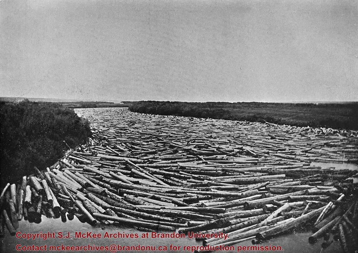
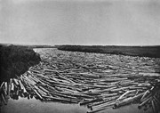
Probably the peak of the sawmilling industry in Brandon was "The Big Drive" in 1910, when 125 drivers brought 5 million board feet of timber down the Assiniboine to Hanbury's Mill.
Most of these logs were cut in the Riding Mountains in winter and floated down the Little Saskatchewan and Birdtail Rivers to the Assiniboine.
Custodial History
For custodial history see the collection level description of the Lawrence Stuckey collection.
Scope and Content
Logs, destined for Hanbury Manufacturing Co., in the Assiniboine River
Notes
Looking north from 3rd Street.
[This negative was produced using a previously published image (P.E.).]
Also see file H9a
Name Access
Hanbury Manufacturing Co.
Subject Access
manufactured products
mills
saw mills
forest products
logs
lumber
Brandon Industries
Repro Restriction
The McKee Archives is the copyright holder for the Stuckey materials.
Storage Location
Lawrence Stuckey collection
Images
Show Less

British American dealers - aerial view looking north at intersection of Highways 1 and 10

http://archives.brandonu.ca/en/permalink/descriptions11240
Part Of
CKX fonds
Description Level
Item
GMD
graphic
Date Range
after 1954
Accession Number
11-2010
Part Of
CKX fonds
Creator
CKX
Description Level
Item
Item Number
11-2010.B3u
Accession Number
11-2010
GMD
graphic
Date Range
after 1954
Physical Description
5" x 4" (b/w)
Material Details
Negative
Custodial History
See fonds level of the CKX records for custodial history.
Scope and Content
Image consists of an aerial view looking north at the intersection of Highways 1 and 10 and shows the British American dealer located at the intersection.
Name Access
CKX
British American Dealers
Brandon, Manitoba
Subject Access
aerial photographs
Storage Location
CKX fonds - 2010 accessions
Images
Show Less

Ruins of abandoned stone house, northwest of Justice, Manitoba

http://archives.brandonu.ca/en/permalink/descriptions10896
Part Of
RG 11 Lawrence Stuckey fonds
Description Level
Item
GMD
graphic
Date Range
December 19, 1978
Accession Number
1-2002
Part Of
RG 11 Lawrence Stuckey fonds
Creator
L.A. Stuckey
Description Level
Item
Series Number
3.3
Item Number
1-2002.3.3.BNE[318a]
Accession Number
1-2002
GMD
graphic
Date Range
December 19, 1978
Physical Description
2.25" x 2.25" (b/w)
Material Details
Negative
Custodial History
For custodial history see the collection level description of the Lawrence Stuckey collection.
Scope and Content
Image of ruins of abandoned stone house, northwest of Justice, Manitoba.
Notes
[Brandon NE includes communities north of Trans-Canada #1 highway and east of PTH #10.]
Name Access
Justice, Manitoba
Subject Access
houses
Repro Restriction
The McKee Archives is the copyright holder of the Stuckey materials.
Storage Location
Lawrence Stuckey collection
Arrangement
[Mr. Stuckey put three negatives in same envelope. We have separated them and numbered them (318a) to (318c)].
Images
Show Less

Ruins of abandoned stone house, northwest of Justice, Manitoba

http://archives.brandonu.ca/en/permalink/descriptions10898
Part Of
RG 11 Lawrence Stuckey fonds
Description Level
Item
GMD
graphic
Date Range
December 19, 1978
Accession Number
1-2002
Part Of
RG 11 Lawrence Stuckey fonds
Creator
L.A. Stuckey
Description Level
Item
Series Number
3.3
Item Number
1-2002.3.3.BNE[318b]
Accession Number
1-2002
GMD
graphic
Date Range
December 19, 1978
Physical Description
2.25" x 2.25" (b/w)
Material Details
Negative
Custodial History
For custodial history see the collection level description of the Lawrence Stuckey collection.
Scope and Content
Image of ruins of abandoned stone house, northwest of Justice, Manitoba.
Notes
[Brandon NE includes communities north of Trans-Canada #1 highway and east of PTH #10.]
Name Access
Justice, Manitoba
Subject Access
houses
Repro Restriction
The McKee Archives is the copyright holder of the Stuckey materials.
Storage Location
Lawrence Stuckey collection
Arrangement
[Mr. Stuckey put three negatives in same envelope. We have separated them and numbered them (318a) to (318c)].
Images
Show Less

Ruins of abandoned stone house, northwest of Justice, Manitoba

http://archives.brandonu.ca/en/permalink/descriptions10899
Part Of
RG 11 Lawrence Stuckey fonds
Description Level
Item
GMD
graphic
Date Range
December 19, 1978
Accession Number
1-2002
Part Of
RG 11 Lawrence Stuckey fonds
Creator
L.A. Stuckey
Description Level
Item
Series Number
3.3
Item Number
1-2002.3.3.BNE[318c]
Accession Number
1-2002
GMD
graphic
Date Range
December 19, 1978
Physical Description
2.25" x 2.25" (b/w)
Material Details
Negative
Custodial History
For custodial history see the collection level description of the Lawrence Stuckey collection.
Scope and Content
Image of ruins of abandoned stone house, northwest of Justice, Manitoba.
Notes
[Brandon NE includes communities north of Trans-Canada #1 highway and east of PTH #10.]
Name Access
Justice, Manitoba
Subject Access
houses
Repro Restriction
The McKee Archives is the copyright holder of the Stuckey materials.
Storage Location
Lawrence Stuckey collection
Arrangement
[Mr. Stuckey put three negatives in same envelope. We have separated them and numbered them (318a) to (318c)].
Images
Show Less

British American dealers - aerial view looking southeast from intersection of Highways 1 and 10

http://archives.brandonu.ca/en/permalink/descriptions11242
Part Of
CKX fonds
Description Level
Item
GMD
graphic
Date Range
after 1954
Accession Number
11-2010
Part Of
CKX fonds
Creator
CKX
Description Level
Item
Item Number
11-2010.B3v
Accession Number
11-2010
GMD
graphic
Date Range
after 1954
Physical Description
5" x 4" (b/w)
Material Details
Negative
Custodial History
See fonds level of the CKX records for custodial history.
Scope and Content
Image consists of an aerial view looking southeast at the intersection of Highways 1 and 10 and shows the British American dealer located at the intersection.
Name Access
CKX
British American Dealers
Brandon, Manitoba
Subject Access
aerial photographs
Storage Location
CKX fonds - 2010 accessions
Images
Show Less

British American dealers - aerial view looking northeast from intersection of Highways 1 and 10

http://archives.brandonu.ca/en/permalink/descriptions11243
Part Of
CKX fonds
Description Level
Item
GMD
graphic
Date Range
after 1954
Accession Number
11-2010
Part Of
CKX fonds
Creator
CKX
Description Level
Item
Item Number
11-2010.B3w
Accession Number
11-2010
GMD
graphic
Date Range
after 1954
Physical Description
5" x 4" (b/w)
Material Details
Negative
Custodial History
See fonds level of the CKX records for custodial history.
Scope and Content
Image consists of an aerial view looking northeast at the intersection of Highways 1 and 10 and shows the British American dealer located at the intersection.
Name Access
CKX
British American Dealers
Brandon, Manitoba
Subject Access
aerial photographs
Storage Location
CKX fonds - 2010 accessions
Images
Show Less

20 records – page 2 of 1.