Skip header and navigation

Revise Search

20 records – page 8 of 1.

100-block 10th Street, facing southwest (2)

http://archives.brandonu.ca/en/permalink/descriptions8407
Part Of
Joseph H. Hughes collection
Description Level
Item
GMD
graphic
Date Range
c. 1950
Accession Number
3-1997
Part Of
Joseph H. Hughes collection
Description Level
Item
Series Number
3-1997.1
Item Number
3-1997.1.29
Accession Number
3-1997
GMD
graphic
Date Range
c. 1950
Physical Description
8 " x 10" (b/w)
Physical Condition
good
Scope and Content
Photograph shows the west side of 10th Street between Rosser and Princess Avenues. Visible businesses include: Recreation Bowling & Billiards, Bottomley's, Barry Neill Men's Wear, Simpsons-Sears, Allied Hardware Stores, Box Brothers Hardware, Doig's. Painted on the north face of the Strathcona Block are two advertisements, one for Sutherland and Robertson [Grocery] and the other for Boyd Electric Co. Ltd.
Name Access
10th Street
Recreation Bowling and Billiards
Bottomley's
Barry Neill Men's Wear
Simpsons-Sears Ltd.
Sutherland and Robertson
Boyd Electric Co. Ltd.
Strathcona Block
Box Brothers Hardware
Doig's
Allied Hardware
Alexandra Block
Subject Access
downtowns
street scenes
Brandon business buildings & facilities after 1940
building exteriors
Storage Location
RG 5 photograph storage drawer
Images
Show Less

Brandon Sun Building

http://archives.brandonu.ca/en/permalink/descriptions9551
Part Of
RG 11 Lawrence Stuckey fonds
Description Level
Item
GMD
graphic
Date Range
April 13, 1975
Accession Number
1-2002
Part Of
RG 11 Lawrence Stuckey fonds
Creator
L.A. Stuckey
Description Level
Item
Series Number
3.1
Item Number
1-2002.3.1EA15
Accession Number
1-2002
GMD
graphic
Date Range
April 13, 1975
Physical Description
2 1/2" x 2 1/2"
Material Details
Negative
History / Biographical
Built by the John Deere farm implement company (late 1940's?).
Custodial History
For custodial history see the collection level description of the Lawrence Stuckey collection.
Scope and Content
Brandon Sun Building
Name Access
Brandon Sun
Subject Access
businesses
newspaper buildings
Brandon business buildings & facilities after 1940
Repro Restriction
The McKee Archives is the copyright holder for the Stuckey materials.
Location Copy
1-2002.3.9.38
Storage Location
Lawrence Stuckey collection
Images
Show Less

Brandon Fire Station No.2

http://archives.brandonu.ca/en/permalink/descriptions13996
Part Of
Fred McGuinness collection
Description Level
Item
GMD
graphic
Date Range
[1913-1919]
Accession Number
1-2015
Part Of
Fred McGuinness collection
Creator
Photographer: Martel's Limited Brandon
Description Level
Item
Series Number
McG 9
Item Number
1-2015.66
Accession Number
1-2015
GMD
graphic
Date Range
[1913-1919]
Physical Description
7" x 4.75" (b/w)
Material Details
on matting
Custodial History
Photograph was given to Fred McGuinness by Linda Bilkoski (nee Lepard) of Lac du Bonnet, MB.
Notes
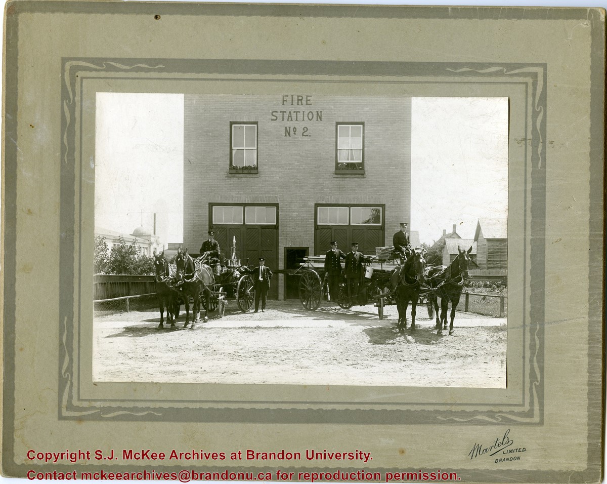
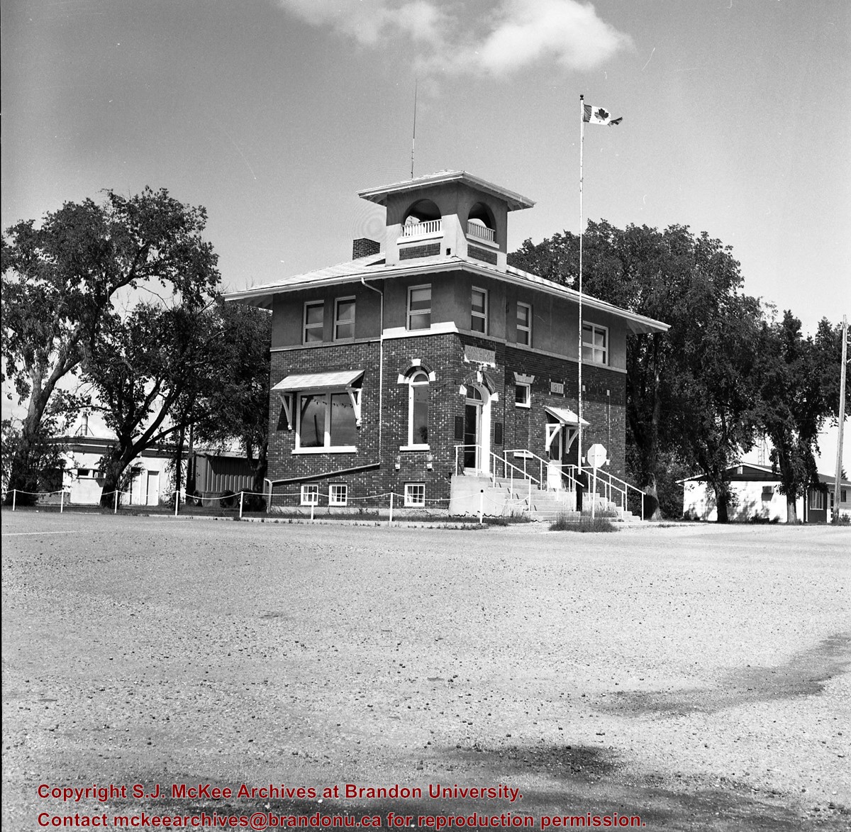
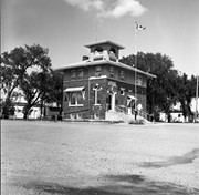
Photograph shows two horse-drawn fire wagons in front of the Brandon Fire Station No. 2. One wagon has a hose, the other wagon has an extension ladder. Fireman Ed Harden is on the reins of the ladder truck (right). Writing on the back of photograph reads: Contributed by Mrs. Ed Harden. 6th Street North, 11th & McTavish Ave, Fire Hall - now School Bd office. This picture is the same as the negative in the Lawrence Stuckey collection. Stuckey obtained a copy of the photo from George Lepard, father of Linda Bilkoski (nee Lepard).
Name Access
Brandon Fire Department
Fire Station No. 2
Brandon Fire Department Personnel
Brandon fire halls
Ed Harden
Brandon Fire Department Ladder Wagon
Subject Access
Brandon business buildings & facilities before 1940
Brandon Fire Department Stations & Equipment
fire halls
fire engines
building exteriors
firefighters
Storage Location
RG 5 photograph storage drawer 2 (hanging photos)
Related Material
Lawrence Stuckey collection 1-2002.3.1F6
Arrangement
McG 4.1 File 27
Images
Show Less

Municipal Building, Reston, Manitoba

http://archives.brandonu.ca/en/permalink/descriptions10338
Part Of
RG 11 Lawrence Stuckey fonds
Description Level
Item
GMD
graphic
Date Range
July 1, 1986
Accession Number
1-2002
Part Of
RG 11 Lawrence Stuckey fonds
Creator
L.A. Stuckey
Description Level
Item
Series Number
3.3
Item Number
1-2002.3.3.CPR[73]
Accession Number
1-2002
GMD
graphic
Date Range
July 1, 1986
Physical Description
2.5" x 2.7" (b/w)
Material Details
Negative
History / Biographical
Mr. Stuckey's notes: Built 1917.
Custodial History
For custodial history see the collection level description of the Lawrence Stuckey collection.
Scope and Content
Image of the Municipal Building in Reston, Manitoba. Image was taken along the CPR lines south of the mainline.
Name Access
Reston
Reston Municipal building
Subject Access
public buildings
Repro Restriction
The McKee Archives is the copyright holder of the Stuckey materials.
Storage Location
Lawrence Stuckey collection
Images
Show Less

A.E. McKenzie Building construction

http://archives.brandonu.ca/en/permalink/descriptions627
Part Of
Brandon University Photograph collection
Description Level
Item
GMD
graphic
Date Range
[1959-1960]
Part Of
Brandon University Photograph collection
Description Level
Item
Series Number
2.4
Item Number
BUPC 2.4.6
GMD
graphic
Date Range
[1959-1960]
Physical Description
5" x 7" (b/w)
Scope and Content
Photograph is looking northeast (?) and shows the construction of the A.E. McKenzie Building (Library and Arts Building) during the winter.
Subject Access
campus buildings
Images
Show Less

Aerial view: Brandon University campus

http://archives.brandonu.ca/en/permalink/descriptions8046
Part Of
Aerial views and campus photographs
Description Level
Item
GMD
graphic
Date Range
late 1970s
Part Of
Aerial views and campus photographs
Description Level
Item
Series Number
2.1
Item Number
2.1.115
GMD
graphic
Date Range
late 1970s
Physical Description
5" x 3.5" (colour)
Scope and Content
View is southwest from approximately Princess Avenue and 17th Street. Photograph shows the Brandon University campus in fall, as well as the southwest portion of the city.
Images
Show Less

Aerial view: Brandon University campus

http://archives.brandonu.ca/en/permalink/descriptions8047
Part Of
Aerial views and campus photographs
Description Level
Item
GMD
graphic
Date Range
1967-1969
Part Of
Aerial views and campus photographs
Description Level
Item
Series Number
2.1
Item Number
2.1.116
GMD
graphic
Date Range
1967-1969
Physical Description
5" x 4" (colour)
Scope and Content
View is south southwest from approximatley the east corner of 18th Street and Princess Avenue. Photograph shows the Brandon University campus, Kinsmen Stadium, Earl Oxford school and a number of residential blocks, particularly southwest of 18th Street.
Images
Show Less

Aerial view: Brandon University campus

http://archives.brandonu.ca/en/permalink/descriptions8048
Part Of
Aerial views and campus photographs
Description Level
Item
GMD
graphic
Date Range
1967-1969
Part Of
Aerial views and campus photographs
Description Level
Item
Series Number
2.1
Item Number
2.1.117
GMD
graphic
Date Range
1967-1969
Physical Description
5" x 4" (colour)
Scope and Content
View is southeast from approximatley 23rd Street and Rosser Avenue. Photograph shows the Brandon University campus, Kinsmen Stadium, Earl Oxford school, the Fair Grounds (including the Grandstand and Racetrack) and a number of residential blocks, particularly in the southeast part of the city.
Images
Show Less

Aerial view: Brandon University campus

http://archives.brandonu.ca/en/permalink/descriptions8049
Part Of
Aerial views and campus photographs
Description Level
Item
GMD
graphic
Date Range
1967-1969
Part Of
Aerial views and campus photographs
Description Level
Item
Series Number
2.1
Item Number
2.1.118
GMD
graphic
Date Range
1967-1969
Physical Description
5" x 3.5" (colour)
Scope and Content
View is west from 17th Street between Louise and Princess Avenues. Photograph shows the Brandon University Campus, Fleming School and Coronation Park, as well as a number of residential blocks.
Images
Show Less

Aerial view: Brandon University campus

http://archives.brandonu.ca/en/permalink/descriptions8050
Part Of
Aerial views and campus photographs
Description Level
Item
GMD
graphic
Date Range
c. 2000
Part Of
Aerial views and campus photographs
Creator
Photographer: Sandy Black
Description Level
Item
Series Number
2.1
Item Number
2.1.119
GMD
graphic
Date Range
c. 2000
Physical Description
8" x 5" (colour)
Scope and Content
View is southwest from the 200 block of 17th Street. Photograph shows the Brandon University campus, Kinsmen Stadium, Fleming School and a number of residential blocks.
Show Less

Aerial view: Brandon University campus

http://archives.brandonu.ca/en/permalink/descriptions8051
Part Of
Aerial views and campus photographs
Description Level
Item
GMD
graphic
Date Range
c. 1978
Part Of
Aerial views and campus photographs
Description Level
Item
Series Number
2.1
Item Number
2.1.120
GMD
graphic
Date Range
c. 1978
Physical Description
7" x 5" (colour)
Scope and Content
View is south southeast from approsimatley Rosser Avenue and 21st Street. Photograph shows the Brandon University campus, Kinsmen Stadium, Earl Oxford School, the Fair Grounds (including the Grand Stand and Race Track), and a number of residential blocks.
Images
Show Less

Aerial view: Brandon College campus

http://archives.brandonu.ca/en/permalink/descriptions8052
Part Of
Aerial views and campus photographs
Description Level
Item
GMD
graphic
Date Range
c. 1963
Part Of
Aerial views and campus photographs
Description Level
Item
Series Number
2.1
Item Number
2.1.121
GMD
graphic
Date Range
c. 1963
Physical Description
10" x 8" (b/w)
Scope and Content
View is southwest from the northeast corner of the Brandon College campus. Flora Cowan Hall is under construction.
Images
Show Less

Aerial view: Brandon University campus

http://archives.brandonu.ca/en/permalink/descriptions8053
Part Of
Aerial views and campus photographs
Description Level
Item
GMD
graphic
Date Range
c. 1967
Part Of
Aerial views and campus photographs
Description Level
Item
Series Number
2.1
Item Number
2.1.122
GMD
graphic
Date Range
c. 1967
Physical Description
10" x 8" (colour)
Scope and Content
View is south southwest from approximatley the southwest corner of 18th Street and Princess Avenue. Photograph shows the University campus, Kinsmen Stadium, Earl Oxford School and residential blocks.
Images
Show Less

Aerial view: Brandon University campus

http://archives.brandonu.ca/en/permalink/descriptions8054
Part Of
Aerial views and campus photographs
Description Level
Item
GMD
graphic
Date Range
c. 1967
Part Of
Aerial views and campus photographs
Description Level
Item
Series Number
2.1
Item Number
2.1.123
GMD
graphic
Date Range
c. 1967
Physical Description
10" x 8" (colour)
Scope and Content
View is west from 17th Street between Louise and Princess Avenues to approximalety 25th Street. Photograph shows the University campus, Fleming School, Coronation Park and residential blocks.
Images
Show Less

Aerial view: Brandon College campus

http://archives.brandonu.ca/en/permalink/descriptions8055
Part Of
Aerial views and campus photographs
Description Level
Item
GMD
graphic
Date Range
c. 1963
Part Of
Aerial views and campus photographs
Description Level
Item
Series Number
2.1
Item Number
2.1.124
GMD
graphic
Date Range
c. 1963
Physical Description
8" x 10" (b/w)
Physical Condition
A problem during development has obscured a portion of Kinsmen Stadium and the southeast corner of the campus.
Scope and Content
View is north from Victoria Avenue between 18th and 20th Streets to the railway tracks. Photograph shows Kinsmen Stadium, the College campus and a number of residential blocks.
Images
Show Less

Aerial view: Brandon College campus

http://archives.brandonu.ca/en/permalink/descriptions8056
Part Of
Aerial views and campus photographs
Description Level
Item
GMD
graphic
Date Range
c. 1963
Part Of
Aerial views and campus photographs
Description Level
Item
Series Number
2.1
Item Number
2.1.125
GMD
graphic
Date Range
c. 1963
Physical Description
10" x 8" (b/w)
Scope and Content
View is northeast from approximately the southwest corner of Victoria Avenue and 22nd Street to the Assiniboine River near 1st Street. Photograph shows the College campus, Kinsmen Stadium, residential blocks, downtown and the railway tracks.
Images
Show Less

Aerial view: Brandon University campus

http://archives.brandonu.ca/en/permalink/descriptions8057
Part Of
Aerial views and campus photographs
Description Level
Item
GMD
graphic
Date Range
c. 1967
Part Of
Aerial views and campus photographs
Description Level
Item
Series Number
2.1
Item Number
2.1.126
GMD
graphic
Date Range
c. 1967
Physical Description
10" x 8" (colour)
Scope and Content
View is southeast from north of the corner of Princess Avenue and 22nd Street to approximatley Brandon Avenue. Photograph shows the University campus, Kinsmen Stadium, Earl Oxford School, and residential blocks. Brandon Collegiate Institute (BCI) is visible in the upper left corner.
Images
Show Less

Aerial view: Brandon University campus

http://archives.brandonu.ca/en/permalink/descriptions8058
Part Of
Aerial views and campus photographs
Description Level
Item
GMD
graphic
Date Range
c. 1967
Part Of
Aerial views and campus photographs
Description Level
Item
Series Number
2.1
Item Number
2.1.127
GMD
graphic
Date Range
c. 1967
Physical Description
10" x 8" (b/w)
Scope and Content
View is west southwest from approximatley the northside of Princess Avenue just east of 18th Street. Photograph shows the University campus, part of Kinsmen Stadium and residential blocks.
Images
Show Less

Aerial view: Brandon University campus

http://archives.brandonu.ca/en/permalink/descriptions8059
Part Of
Aerial views and campus photographs
Description Level
Item
GMD
graphic
Date Range
c. 1967
Part Of
Aerial views and campus photographs
Description Level
Item
Series Number
2.1
Item Number
2.1.128
GMD
graphic
Date Range
c. 1967
Physical Description
10" x 8" (b/w)
Scope and Content
View is northwest from approximatley the southeast corner of 18th Street and Louise Avenue. Photograph shows the University campus and residential blocks.
Images
Show Less

Aerial view: Brandon University campus

http://archives.brandonu.ca/en/permalink/descriptions8060
Part Of
Aerial views and campus photographs
Description Level
Item
GMD
graphic
Date Range
c. 1978
Part Of
Aerial views and campus photographs
Description Level
Item
Series Number
2.1
Item Number
2.1.129
GMD
graphic
Date Range
c. 1978
Physical Description
10" x 8" (b/w)
Scope and Content
View is southwest from approximatley the corner of 17th Street and Princess Avenue to McDiarmid Drive. Photograph shows the Brandon University campus, Kinsmen Stadium, Fleming School, Coronation Park and residential blocks.
Images
Show Less

20 records – page 8 of 1.