Skip header and navigation

Revise Search

20 records – page 3 of 1.

Brandon College campus

http://archives.brandonu.ca/en/permalink/descriptions819
Part Of
Aerial views and campus photographs
Description Level
Item
GMD
graphic
Date Range
c. 1960s
Part Of
Aerial views and campus photographs
Description Level
Item
Series Number
2.1
Item Number
2.1.51
GMD
graphic
Date Range
c. 1960s
Physical Description
10" x 8" (b/w)
Scope and Content
View is southwest. Photograph shows Clark Hall, the Brandon College Building, the Citizens' Science Building and the driveway running in front of the buildings. Portions of the front lawn and the Kinsmen Staduim are also visible.
Images
Show Less

Brandon University campus

http://archives.brandonu.ca/en/permalink/descriptions836
Part Of
Aerial views and campus photographs
Description Level
Item
GMD
graphic
Date Range
1977
Part Of
Aerial views and campus photographs
Description Level
Item
Series Number
2.1
Item Number
2.1.52
GMD
graphic
Date Range
1977
Physical Description
10" x 8" (b/w)
Scope and Content
View is northeast fron the west side of the Dining Hall. Photograph shows portions of the J.R.C. Evans Lecture Theatre and the A.E. McKenzie Building, as well as an H-Hut, Clark Hall, the Brandon College Building and the quadrangle.
Images
Show Less

Brandon University driveway

http://archives.brandonu.ca/en/permalink/descriptions841
Part Of
Aerial views and campus photographs
Description Level
Item
GMD
graphic
Date Range
c. 1980s
Part Of
Aerial views and campus photographs
Description Level
Item
Series Number
2.1
Item Number
2.1.35
GMD
graphic
Date Range
c. 1980s
Physical Description
3.5" x 5" (b/w)
Scope and Content
View is north from approximately the Citizens' Science Building. Photograph shows the driveway running in front of the Brandon College Building and Clark Hall, a number of cars and students along the driveway and the Education Building in the background.
Images
Show Less

Brandon University campus

http://archives.brandonu.ca/en/permalink/descriptions850
Part Of
Aerial views and campus photographs
Description Level
Item
GMD
graphic
Date Range
May 1978
Part Of
Aerial views and campus photographs
Description Level
Item
Series Number
2.1
Item Number
2.1.36
GMD
graphic
Date Range
May 1978
Physical Description
5" x 3.5" (colour)
Scope and Content
View is northwest from the front lawn. Clark Hall and the Education Building are visible between the trees.
Images
Show Less

Brandon University campus

http://archives.brandonu.ca/en/permalink/descriptions866
Part Of
Aerial views and campus photographs
Description Level
Item
GMD
graphic
Date Range
October 1981
Part Of
Aerial views and campus photographs
Description Level
Item
Series Number
2.1
Item Number
2.1.37
GMD
graphic
Date Range
October 1981
Physical Description
3.5" x 5" (colour)
Scope and Content
View is south from the lawn in front of the Education Building and shows a student exiting the building. The driveway and John R. Brodie Science Centre are visible in the background.
Images
Show Less

Brandon College campus

http://archives.brandonu.ca/en/permalink/descriptions916
Part Of
Aerial views and campus photographs
Description Level
Item
GMD
graphic
Date Range
c. 1966
Part Of
Aerial views and campus photographs
Creator
Miles Photos
Description Level
Item
Series Number
2.1
Item Number
2.1.53
GMD
graphic
Date Range
c. 1966
Physical Description
10" x 8" (b/w)
Scope and Content
View is northwest from the front lawn. Photograph shows the Citizens' Science Building, an H-Hut, the Brandon College Building, Clark Hall and the original Music Building.
Images
Show Less

Brandon University campus

http://archives.brandonu.ca/en/permalink/descriptions917
Part Of
Aerial views and campus photographs
Description Level
Item
GMD
graphic
Date Range
c. 1967
Part Of
Aerial views and campus photographs
Description Level
Item
Series Number
2.1
Item Number
2.1.54
GMD
graphic
Date Range
c. 1967
Physical Description
10" x 8" (b/w)
Physical Condition
Photograph has a couple of cracks, due to bending.
Scope and Content
View is northwest from the front lawn. Photograph shows the Brandon College Building, Clark Hall, the parking lot in front of those two buildings and the Education building.
Images
Show Less

Brandon College campus

http://archives.brandonu.ca/en/permalink/descriptions956
Part Of
Aerial views and campus photographs
Description Level
Item
GMD
graphic
Date Range
c. 1950s
Part Of
Aerial views and campus photographs
Description Level
Item
Series Number
2.1
Item Number
2.1.44
GMD
graphic
Date Range
c. 1950s
Physical Description
7" x 5" (b/w)
Scope and Content
View is south southwest from approximatley the location of the current Health Studies Complex. Photograph shows the large field to the north of Clark Hall, Clark Hall, the Brandon College Building, the Citizens' Science Building and an H-Hut behind Clark Hall.
Show Less

Brandon Insane Asylum

http://archives.brandonu.ca/en/permalink/descriptions6431
Part Of
Alf Fowler collection
Description Level
Item
GMD
graphic
Date Range
ca. 1911
Accession Number
6-1999
Part Of
Alf Fowler collection
Creator
Davidson & Gowen
Description Level
Item
Item Number
6-1999.6
Accession Number
6-1999
GMD
graphic
Date Range
ca. 1911
Physical Description
9.5" x 7" (b/w)
Physical Condition
A piece of the photograph is missing on the left side. A small portion of one of the buildings is missing as a result.
History / Biographical
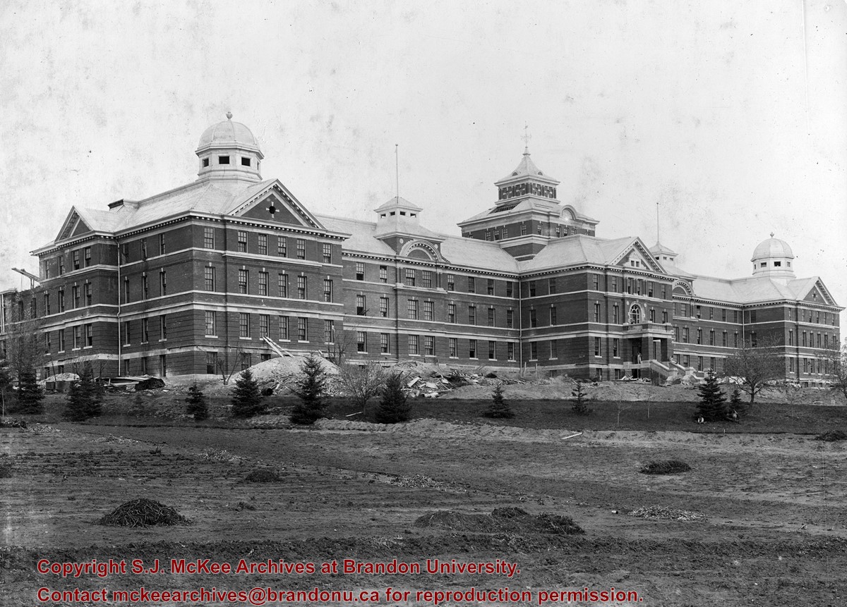
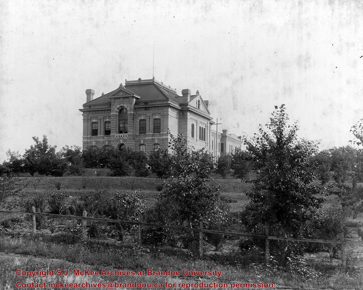
The Brandon Insane Asylum was located on the north bank of the Assiniboine River, two miles north of Brandon. It had a southern aspect.
Custodial History
See fonds level description of the Alf Fowler collection for custodial history.
Scope and Content
Photo was taken looking northeast and shows the front and west side of the Brandon Insane Asylum. Construction materials are visible at the base of the building.
Notes
A 5" x 7" (b/w) reproduction of the photograph is located with the original.
Storage Range
RG 5 Western Manitoba Manuscript collection - photograph storage drawer
Images
Show Less

Brandon General Hospital

http://archives.brandonu.ca/en/permalink/descriptions6432
Part Of
Alf Fowler collection
Description Level
Item
GMD
graphic
Date Range
ca. 1911
Accession Number
6-1999
Part Of
Alf Fowler collection
Creator
Davidson & Gowen
Description Level
Item
Item Number
6-1999.7
Accession Number
6-1999
GMD
graphic
Date Range
ca. 1911
Physical Description
9.25" x 7" (b/w)
History / Biographical
The Brandon General Hospital was located on McTavish Avenue between Russell and Frederick Streets.
Custodial History
See fonds level description of the Alf Fowler collection for custodial history.
Scope and Content
Photo shows the original Brandon General Hospital.
Storage Range
RG 5 Western Manitoba Manuscript collection - photograph storage drawer
Images
Show Less

Brandon court house

http://archives.brandonu.ca/en/permalink/descriptions6433
Part Of
Alf Fowler collection
Description Level
Item
Accession Number
6-1999
Part Of
Alf Fowler collection
Description Level
Item
Item Number
6-1999.8
Accession Number
6-1999
Physical Description
9.25" x 7.25" (b/w)
Storage Range
RG 5 Western Manitoba Manuscript collection - photograph storage drawer
Images
Show Less

The Brandon Brewing Co.

http://archives.brandonu.ca/en/permalink/descriptions6451
Part Of
Alf Fowler collection
Description Level
Item
Accession Number
6-1999
Part Of
Alf Fowler collection
Description Level
Item
Item Number
6-1999.26
Accession Number
6-1999
Physical Description
9" x 7" (b/w)
Storage Range
RG 5 Western Manitoba Manuscript collection - photograph storage drawer
Images
Show Less

Brandon Produce Company

http://archives.brandonu.ca/en/permalink/descriptions6458
Part Of
Alf Fowler collection
Description Level
Item
GMD
graphic
Date Range
ca. 1911
Accession Number
6-1999
Part Of
Alf Fowler collection
Creator
Davidson & Gowen
Description Level
Item
Item Number
6-1999.33
Accession Number
6-1999
GMD
graphic
Date Range
ca. 1911
Physical Description
7.25" x 9" (b/w)
History / Biographical
The Brandon Produce Company was located at 1018 Pacific Avenue.
Custodial History
See fonds level description of the Alf Fowler collection for custodial history.
Scope and Content
Photo shows the premises of the Brandon Produce Company.
Storage Range
RG 5 Western Manitoba Manuscript collection - photograph storage drawer
Images
Show Less

Brandon Cold Storage

http://archives.brandonu.ca/en/permalink/descriptions6462
Part Of
Alf Fowler collection
Description Level
Item
Accession Number
6-1999
Part Of
Alf Fowler collection
Description Level
Item
Item Number
6-1999.37
Accession Number
6-1999
Physical Description
9.25" x 7.25" (b/w)
Storage Range
RG 5 Western Manitoba Manuscript collection - photograph storage drawer
Images
Show Less

Brandon Pump Works

http://archives.brandonu.ca/en/permalink/descriptions6469
Part Of
Alf Fowler collection
Description Level
Item
Accession Number
6-1999
Part Of
Alf Fowler collection
Description Level
Item
Item Number
6-1999.44
Accession Number
6-1999
Physical Description
9.25" x 7" (b/w)
Storage Range
RG 5 Western Manitoba Manuscript collection - photograph storage drawer
Images
Show Less

Brandon Sandstone Brick Co.

http://archives.brandonu.ca/en/permalink/descriptions6455
Part Of
Alf Fowler collection
Description Level
Item
GMD
graphic
Date Range
ca. 1911
Accession Number
6-1999
Part Of
Alf Fowler collection
Creator
Davidson & Gowen
Description Level
Item
Item Number
6-1999.30
Accession Number
6-1999
GMD
graphic
Date Range
ca. 1911
Physical Description
9.5" x 7" (b/w)
History / Biographical
The Brandon Sandstone Brick Co. Ltd. was located on Princess Avenue between 29th and 30th Streets.
Custodial History
See fonds level description of the Alf Fowler collection for custodial history.
Scope and Content
Photo shows the premises of the Brandon Sandstone Brick Co.
Storage Range
RG 5 Western Manitoba Manuscript collection - photograph storage drawer
Images
Show Less

Aerial view: Brandon University campus

http://archives.brandonu.ca/en/permalink/descriptions8046
Part Of
Aerial views and campus photographs
Description Level
Item
GMD
graphic
Date Range
late 1970s
Part Of
Aerial views and campus photographs
Description Level
Item
Series Number
2.1
Item Number
2.1.115
GMD
graphic
Date Range
late 1970s
Physical Description
5" x 3.5" (colour)
Scope and Content
View is southwest from approximately Princess Avenue and 17th Street. Photograph shows the Brandon University campus in fall, as well as the southwest portion of the city.
Images
Show Less

Aerial view: Brandon University campus

http://archives.brandonu.ca/en/permalink/descriptions8047
Part Of
Aerial views and campus photographs
Description Level
Item
GMD
graphic
Date Range
1967-1969
Part Of
Aerial views and campus photographs
Description Level
Item
Series Number
2.1
Item Number
2.1.116
GMD
graphic
Date Range
1967-1969
Physical Description
5" x 4" (colour)
Scope and Content
View is south southwest from approximatley the east corner of 18th Street and Princess Avenue. Photograph shows the Brandon University campus, Kinsmen Stadium, Earl Oxford school and a number of residential blocks, particularly southwest of 18th Street.
Images
Show Less

Aerial view: Brandon University campus

http://archives.brandonu.ca/en/permalink/descriptions8048
Part Of
Aerial views and campus photographs
Description Level
Item
GMD
graphic
Date Range
1967-1969
Part Of
Aerial views and campus photographs
Description Level
Item
Series Number
2.1
Item Number
2.1.117
GMD
graphic
Date Range
1967-1969
Physical Description
5" x 4" (colour)
Scope and Content
View is southeast from approximatley 23rd Street and Rosser Avenue. Photograph shows the Brandon University campus, Kinsmen Stadium, Earl Oxford school, the Fair Grounds (including the Grandstand and Racetrack) and a number of residential blocks, particularly in the southeast part of the city.
Images
Show Less

Aerial view: Brandon University campus

http://archives.brandonu.ca/en/permalink/descriptions8049
Part Of
Aerial views and campus photographs
Description Level
Item
GMD
graphic
Date Range
1967-1969
Part Of
Aerial views and campus photographs
Description Level
Item
Series Number
2.1
Item Number
2.1.118
GMD
graphic
Date Range
1967-1969
Physical Description
5" x 3.5" (colour)
Scope and Content
View is west from 17th Street between Louise and Princess Avenues. Photograph shows the Brandon University Campus, Fleming School and Coronation Park, as well as a number of residential blocks.
Images
Show Less

20 records – page 3 of 1.